Holy Well (lost): OS Grid Reference – SW 6602 2053
Archaeology & History
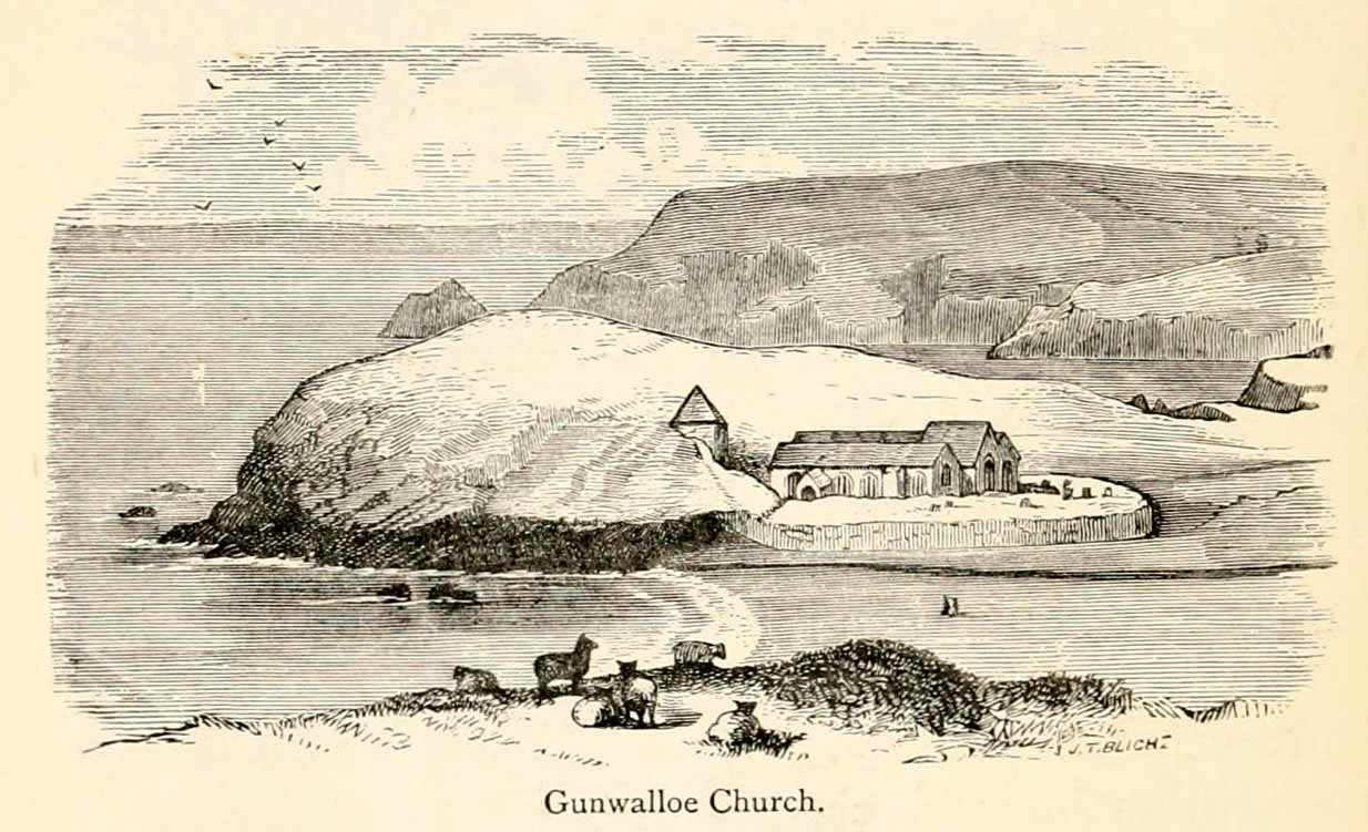
The old church at this headland just above the sea was, said Padel (1988), dedicated to Saint Gunwalloe or Winwalloe in 1332 and is thought to have been the character (a hermit by all accounts) who deemed this well to be ‘holy’. In Alfred Cummings (1875) history of Gunwalloe parish, he devotes a short but singular chapter to this holy well which, according to most accounts, has fallen back to Earth. It was found, said Cummings, “close to the church porch, only a few feet over the precipitous rock…and (was) doubtless the resort in former days of many a lad and maiden.”
Yet even in his day, he lamented its loss, telling that.
“The spring that once bubbled up in its rocky basin is no longer there; sand and stones fill up the well at each high tide, and though occasionally cleaned out for the satisfaction of the wayfarer’s curiosity is yet only an imperfect semblance of its former self.”
Yet remnants of practices and traditions of the well were thankfully remembered:
Gunwalloe church in 1885
“That Gunwalloe was considered by the country folk a well of some importance there can be little doubt, for one day in the year, which was called Gunwalloe Day, was set apart for cleaning out this holy well — it was quite at a different time of year to this parish feast — and now only remembered by two old men out of the whole population of the place.
“They fix the time in their memories as the period of tilling barley, for they recollect that on this Gunwalloe Day it was the custom for the men to mend all the cliff roads (doubtless these were useful in days of smuggling when a successful run was a desirable thing), and so strictly was it kept that, if any were found labouring in the fields, a party would go and take them by force, and press them into the service of the holiday makers, who, having mended the roads and cleared the holy well at Gunwalloe, wound up the day with merriment and revelry.”
Such practices are long since gone of course and, so most modern accounts would tell us, the holy well with it. But when J. Meyrick (1982) came looking for the site on the summer solstice of 1980, he seemed a little more fortunate than his predecessors. Located just a few yards from the detached church tower, he spoke with a
“Mrs Wilson, a churchwarden (who) told me that in heavy rain the tower continues to be flooded so the spring is still somewhere about, and curiously enough by the stile to the beach is a small granite trough with rainwater put there by someone no doubt in lieu of the Well and who is to say that the water is not holy! The stream across the dune still meanders a few feet beneath the tower and into this the water from the well would have run, but there seems now no sign of an originating spring in the rocks around.”
Folklore
The church itself possesses a folktale found up and down the land. “It is said,” wrote Blight (1885),
“that the builders intended to erect the church on higher ground, nearer the centre of the parish, at Hingey; but as fast as materials were brought to the place they were, by some mysterious agency, removed during the night to the present site. And here the church was built, it being found useless to contend with a supernatural power.”
The supernatural agencies that are nearly always responsible for such actions tend to be the devil, fairies or other types of little-people.
References:
Blight, J.T., Churches of West Cornwall, Parker: London 1885.
Holy Well (destroyed): OS Grid Reference – TQ 332 911
Also Known as:
My Lady’s Hole
Archaeology & History
Long since gone after drainage operations on Tottenham Cemetery made the waters dry-up, this was one of several holy wells in the Tottenham area. Its history has been described in various old tomes, but the most definitive is found in William Robinson’s (1840) classic on the parish of Tottenham, when the well was still visible. He told us:
“There is a spring which issues from the side of a small hillock on the south side of the Moselle, nearly opposite the Vicarage, leading thence to the Church, called Bishop’s Well. This spring was formerly considered famous for many strange and wonderful cures performed on the diseased by the use of this water. It has been for some years neglected, but of late the owner of the field in which this well is, had it cleansed, and planted some trees round it, and put up posts and rails to prevent the cattle treading down the sides of it. It is said that the water of this well never freezes. In former times this well was in great repute from the purity of its water. The ladies in the vicinity of it were accustomed to send their servants in the morning and evening for water for their tea, from which circumstance it was for many years known by the name of “My Lady’s Hole.” The water of this well is not only esteemed for its medicinal qualities, but particularly for curing disorders of the eye.
“There were formerly many other springs about the village, especially one which issued out of the hill on which the Church stands; and another in Spottons Wood otherwise Spottons Grove, on the north side of Lordship Lane, which in the fifteenth century was of considerable notoriety; but none of which have in former times been so much frequented and held in such repute as Bishop’s Well.”
(Please note: the grid-reference for this site is an approximation)
References:
Foord, Alfred Stanley, Springs, Streams and Spas of London: History and Association, T. Fisher Unwin: London 1910.
Hope, Robert Charles, Legendary Lore of the Holy Wells of England, Elliott Stock: London 1893.
This was an impressive site by the sound of things. Sadly destroyed, its exact whereabouts isn’t clear but should—if the description of the site is anything to go by—be on one of the highest points of land around Langside Farm. In Irving & Murray’s description (1864), they tell the cairn to have been one amidst a cluster of tombs that could once be seen “a mile to the south of his residence”, but this seems to be contested by the definitive pen of the Lesmahagow historian, John Greenshields. (1864) He told us:
“The late Lord Corehouse had an excavation scientifically made of a karn or cairn on his farm at Longside. It is to be regretted that information cannot now be obtained of so accurate a nature as the subject merits; but there were stones so arranged in the centre as to have been evidently intended for sepulchral purposes. Two rude urns of baked clay, one very large, the other smaller, were found inside a stone coffin. The small urn contained bones partially calcined and broken or pounded, some of them perfectly fresh. It has been erroneously stated in Swan’s “Views of the Clyde,” that there were eighteen small urns around the large chest, in the form of a circle, which gave rise to the idea that the remains of the chief had been surrounded by those of his family or warriors. One of the urns has been lost sight of: the smaller one, about 6 inches in diameter at the top, and 4 in height, is now in the possession of Miss Edmondstoun Cranstoun, as well as a still smaller funerary urn, recently restored by kiln-burning it with some fresh clay.”
Royal Commission on the Ancient and Historical Monuments of Scotland, Lanarkshire: An Inventory of the Prehistoric and Roman Monuments, HMSO: Edinburgh 1978.
Swan, Joseph, Views on the Clyde – Historical and Descriptive, Joseph Swan: Glasgow 1830.
When the local historian John Greenshields (1864) wrote his definitive history of Lesmahagow parish, the book was just going to press when the remains of an ancient tomb was unearthed. We are fortunate that he held publication of the book before adding the brief information about the findings. He told us:
“When these pages were passing through the press, a stone cist was discovered on the farm of Eastwood, by the hollow sound emitted when the ploughshare struck its lid. It was of the usual dimensions (about three feet by two), and contained fragments of bones, and a cinerary urn. There were no indications that a cairn had ever been heaped on its top, but the stones may have long since been removed, as the field was in a high state of cultivation. The bones were much decayed, and the urn was shivered to fragments by the finder, in his anxiety to discover hidden treasures of gold or silver.”
No further information is known to exist about this site. In all probability the cist was Bronze Age in nature, possibly earlier. We surmise this from the rapid rate of decay of artefacts upon it being unearthed.
References:
Greenshields, John B., Annals of the parish of Lesmahagow, Caledonian: Edinburgh 1864.
Royal Commission on the Ancient and Historical Monuments of Scotland, Lanarkshire: An Inventory of the Prehistoric and Roman Monuments, HMSO: Edinburgh 1978.
High up in the landscape on the northwestern edges of Bradford, where we now find the Chellow Heights reservoirs, ancient man saw fit to place the remains of their dead. It’s in a damn good location too, typical of burial sites. The views to the immediate north are directly at Rombalds Moor where, as we all know, Bronze Age and other prehistoric remains are found in huge numbers.
It was during the construction of the Chellow Heights reservoirs when the site was uncovered. Twas here, in June 1921, where segments of three urns and,
“an incomplete incense cup, 2 inches high and 3 inches diameter at its base, were found together with partly burnt bones”,
of what were thought to be a young female adult. There are few other details. The fact that there was no mention of any covering mound, nor mass or stones, strongly implies that neither a tumulus or cairn covered these urns—and neither place-name evidences nor early maps indicate anything to suggest such a monument—so it would be fair to surmise they had been deposited in a stone cist.
References:
Barnes, Bernard, Man and the Changing Landscape, Merseyside County Council 1982.
Longworth, Ian, Collared Urns of the Bronze Age in Great Britain and Ireland, Cambridge University Press 1984.
Rowe, J.H., “An Ancient Burial at Chellow, near Heaton,” in Heaton Review, volume 2, 1928.
Cist (destroyed): OS Grid Reference – SE 1196 3824
Archaeology & History
The remains of a prehistoric tomb existed near the foot-bridge on the south-side of the canal at Dowley Gap, but was destroyed during the building of the sewage works there in 1951. It was reported by a Mr Duncanson to Bradford’s Cartwright Hall archaeology group, who told how they accidentally uncovered it during construction work. He told that the
“stone cist (was) about 3½ feet long and 1½ feet deep and was found on rising ground at the western end of the works where the storm water tanks are now situated.”
We obviously don’t know the age of the cist, but such grave monuments are most commonly Bronze Age. The existence of the Crosley Wood Iron Age enclosure 4-500 yards NNW and the prehistoric circle 800 yards east are the nearest other known early period monuments.
References:
Jackson, Sidney, “Stone Cist at Bingley,” in Cartwright Hall Archaeology Group Bulletin, 3:6, 1958.
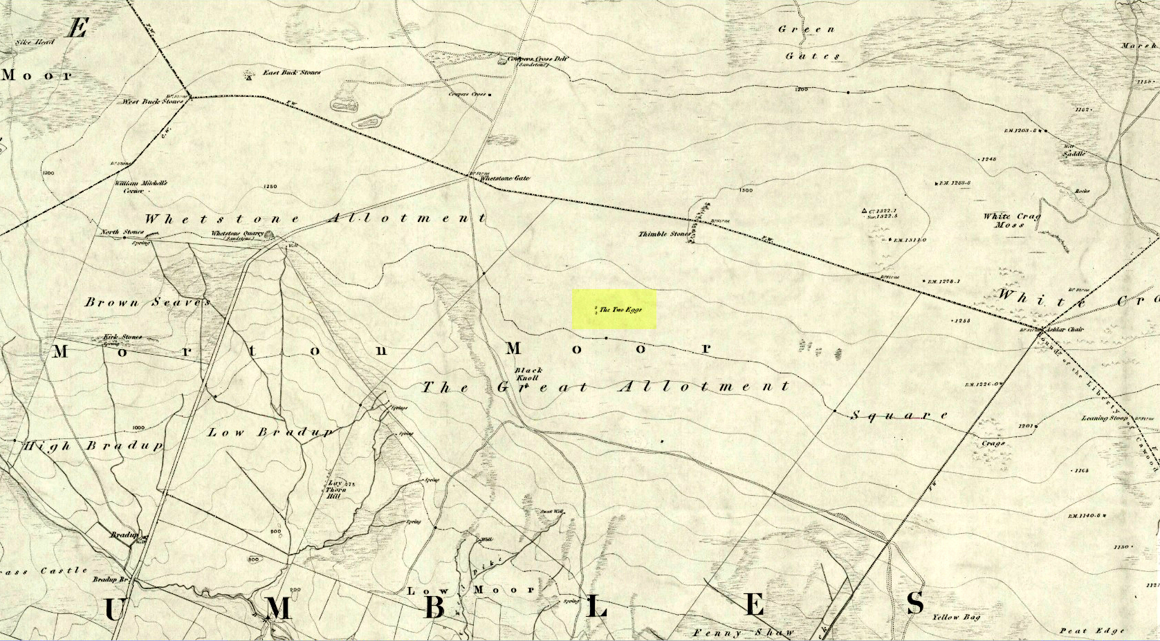
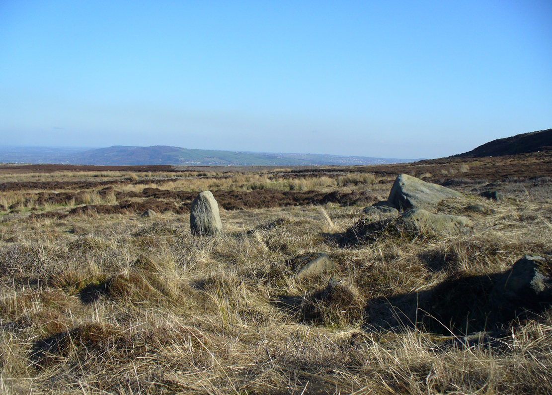
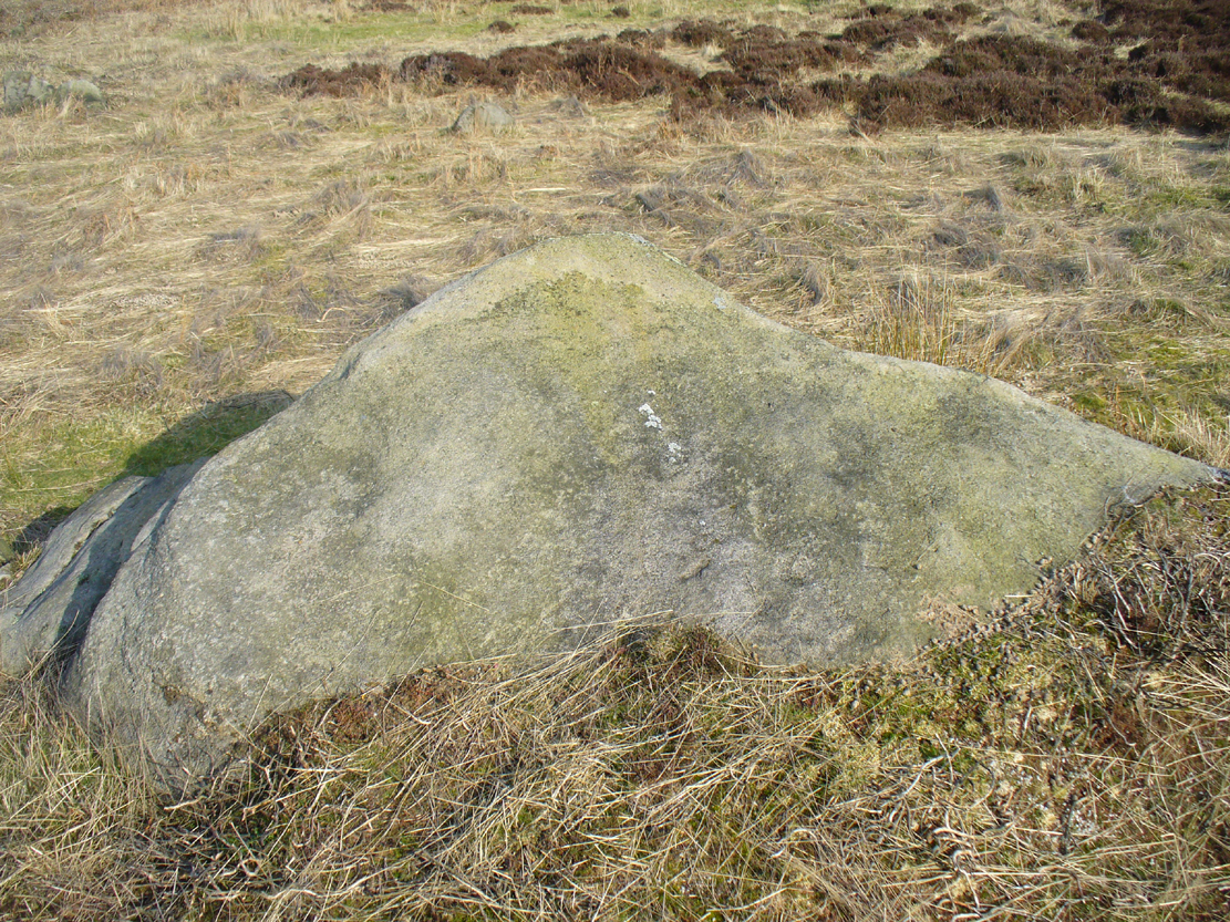
By whichever route you wanna take, get y’self to the prominent cup-and-ring marked rocks known as the Thimble Stones near the very top of these moors. From here, walk roughly 400 yards southwest onto the bare open moors (there are no footpaths here) and you’ll see these two isolated prominent boulders living quietly on their own. You can’t really miss ’em! You’re there.
Archaeology & History
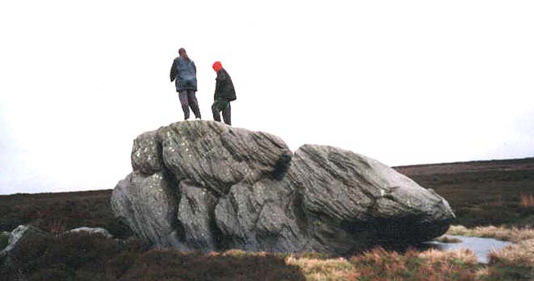
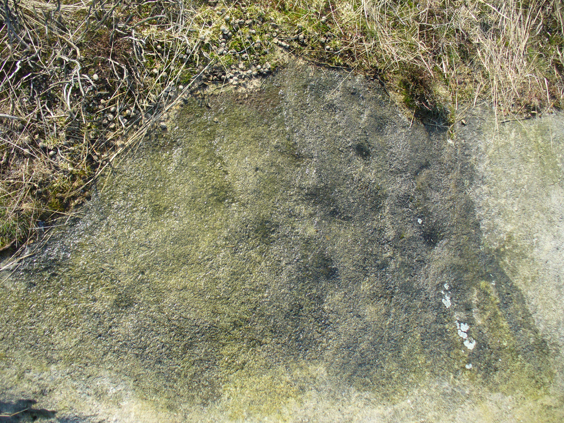
Of the two giant boulders here, both are included in the petroglyph surveys of Hedges (1986) and Boughey & Vickerman’s (2003) as possessing “all natural” cup-marks on their top and vertical surfaces. Those on top of the rocks certainly seem to be Nature’s handiwork, whilst many of the seeming ‘cups’ on the vertical face of one (not the one pictured here) are due to gunshots. I’m not quite sure when they were done, but they certainly didn’t exist during the many visits I made here in the in the 1970s and ’80s.
They stones included in most of the standard antiquarian surveys of the 19th century, with the earliest being Forrest & Grainge (1869) who described them as,
“two detached masses of rock, standing alone upon the moor. The first is 14ft in length by 8ft in height, tapering to the ground; a set of cups and channels occupy the highest point. The other, distant 13 yards, is of an irregular square form, 45 yards in circumference and 7ft high. This stone appears to be tilted on its edge, presenting its cleavage upwards, and has hollows containing water, but is so much wasted above that if it has ever borne the cups and channels, they are now obliterated.”
On top of an Egg, c.1986
Collyer & Turner (1885) described “a number of cups” on the edge of the northern rock; and Romilly Allen (1896) likewise. Even that historical literary giant, Harry Speight (1900), added his own tuppence here, telling folks how both Eggs “are channelled and bear cups.”
It’s very possible that these isolated stones did have some sort of significance to our prehistoric ancestors. There are innumerable examples worldwide of rocks like this possessing ritual and mythic lore—and many in the British Isles too. And the cupmarks on the stones may have been enhanced by those same prehistoric ancestors. But we’ll never know for sure…
Folklore
The creation myth behind the Two Eggs is one echoed in traditions across the world. Folklore tells that the Eggs were said to have been laid here by a great dragon who lived within a hill some distance to the south. All other aspects of the tale have sadly long since been forgotten…
References:
Allen, J. Romilly, “Cup and Ring Sculptures on Ilkley Moor,” in The Reliquary, volume 2, 1896.
Bennett, Paul, The Old Stones of Elmet, Capall Bann: Milverton 2001.
Boughey, Keith & Vickerman, E.A., Prehistoric Rock Art of the West Riding, WYAS: Wakefield 2003.
Collyer, Robert & Turner, J.H., Ilkley: Ancient and Modern, William Walker: Otley 1885.
Forrest, Charles & Grainge, William, A Ramble on Rombald’s Moor, Northern Antiquarian: Bradford 2012 (1st published 1867-69).
Hedges, John (ed.), The Carved Rocks on Rombalds Moor, WYMCC: Wakefield 1986.
Speight, Harry, Upper Wharfedale, Elliott Stock: London 1900.
Follow the directions to reach the impressive Woofa Bank prehistoric enclosure. You need to find the walling that constitutes the enclosure itself and walk along to its eastern side where you’ll reach an ‘opening’, as if it may once have been an entrance at that side of the enclosure. A reasonably large sloping rock is on one side of this ‘entrance’. You can’t really miss it!
Archaeology & History
Unlike many of the other petroglyphs found within the Woofa Bank enclosure, the design on this one is faint — very faint indeed (much like the recently uncovered triple-ring petroglyph by the Thimble Stones). Comprising simply of a small cluster of cup-marks, you’ll struggle to see this one — unlike its compatriot on the western wall of the enclosure.
Looking down on the rockSome very faint cupmarks
It consists of a single cup-mark on the northern edge of the stone, whilst on the sloping southern part of the rock are a number of very faint cups, eroded by them there millenia of Nature’s wind and weathering. One or two of the cups are just visible in good lighting, but what are almost certainly a few more can be seen when the rock is wet and in low daylight hours. It’s a design that’s probably only of interest to the hardcore petroglyph fanatics, but without doubt this is yet another carving within this obviously important prehistoric enclosure.
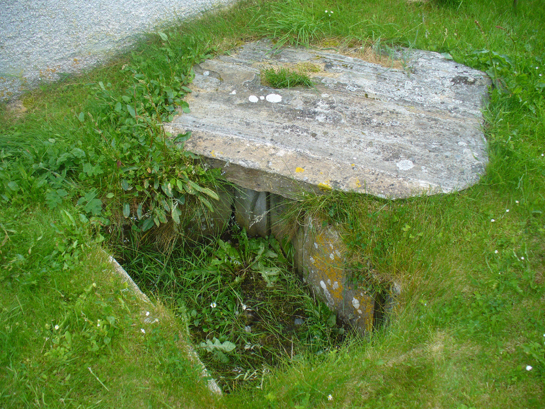
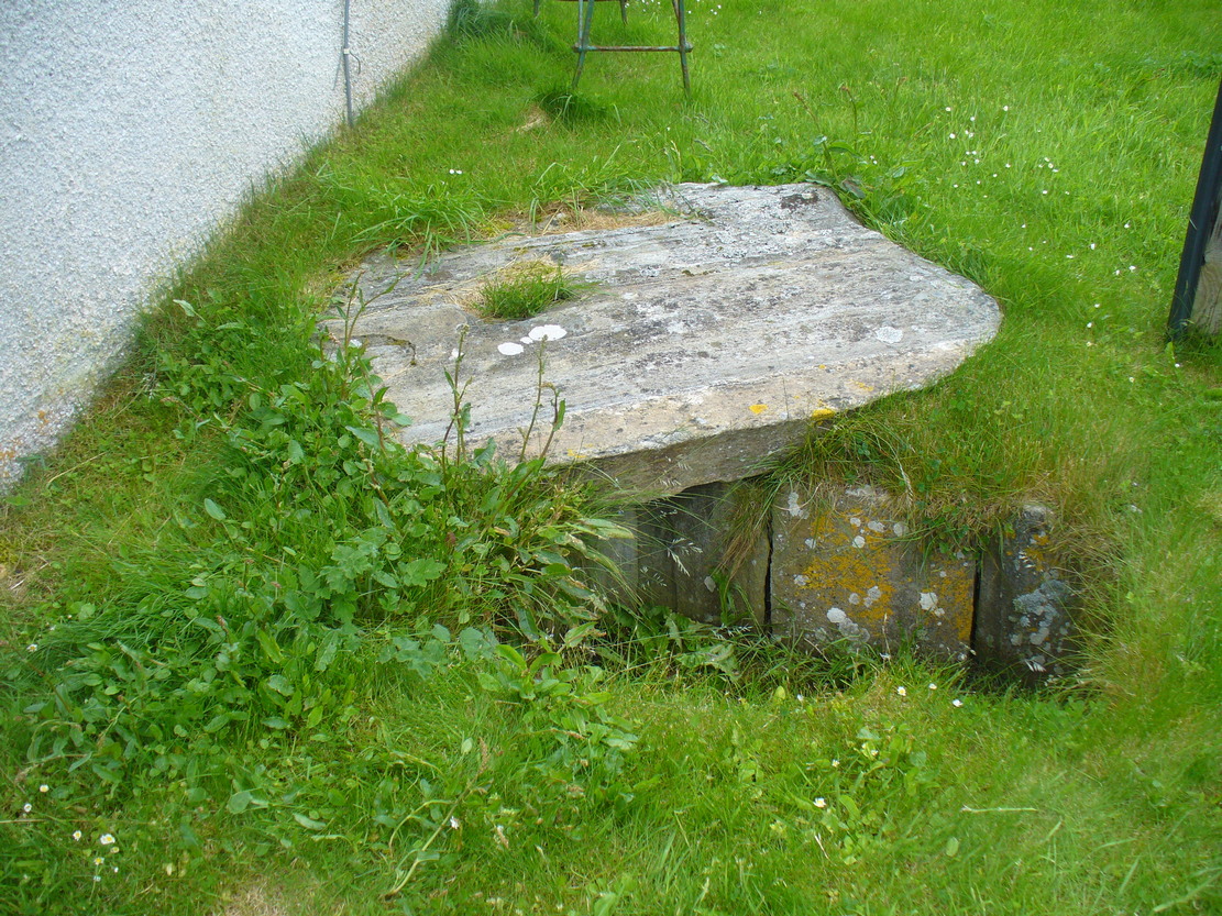
Dead easy. From the top of the hill at Bettyhill, take the road east out of the village along the A836 Thurso road. At the bottom of the hill, on your left, you’ll see the white building of Farr church Museum. Walk to it and instead of going in the door, walk past it and round the back, or north-side of the church where, up against the wall, you’ll see this small stone-lined hole in the ground. Y’ can’t really miss it.
Archaeology & History
Originally located 7½ miles (12.1km) to the south at Chealamy (NC 7240 5017), in the prehistoric paradise of Strathnaver, it was uncovered following road-building operations in 1981 and, to save it from complete destruction, was moved to its present position on the north-side of Farr church museum. It was fortunate in being saved, as it was covered by a large boulder which the road operators tried to smash with a large jack-hammer; but in breaking it up, they noticed a hole beneath it. Thankfully, old Eliot Rudie of Bettyhill—a well respected amateur historian and archaeologist in the area—was driving past just as it had been uncovered by the workmen. He recognised it as being a probable cist and so further operations were stopped until it was investigated more thoroughly.
The relocated cist
The cist—measuring some 4 feet long by 3 feet wide and about 1½ feet deep—contained the burial of what was thought to be a man in his mid- to late-twenties. The remains were obviously in very decayed state and it was thought by archaeologist Robert Gourlay (1996), that the body itself had been “deposited in the grave (when it was) in an advanced state of decomposition.” Also in the cist they found a well-preserved decorated beaker, within which Gourlay thought “probably contained some kind of semi-alcoholic gruel for the journey of the departed to the after-life.”
References:
Gourlay, Robert, Sutherland – An Archaeological Guide, Birlinn: Edinburgh 1996.
Gourlay, Robert B., “A Short Cist Beaker Inhumation from Chealamy, Strathnaver, Sutherland”, in Proceedings Society Antiquaries Scotland, volume 114, 1984.
Gourlay, Robert & Rudie, Eliot, “Chealamy, Strathnaver (Farr) Beaker Cist”, in Discovery Excavation Scotland, 1981.
Acknowledgments: To that inspiring creature Aisha Domleo, for her bounce, spirit and madness to get me up here; and for little Lara too, for meandering to the church museum where this cist can be seen; and to Eliot Rudie, who pointed it out to us.
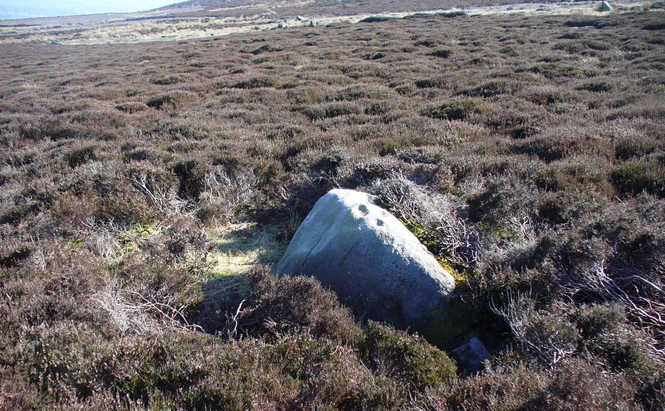
The easiest way to find this is to take the same directions to reach the Woofa Bank settlement. Get your compass out and make sure that you’re at the northern edge of the settlement walling. From here, walk about 60 yards northwest and keep your eyes peeled for a rock about 2 feet high, curved and elongated with its top surface above the heather. You’ll find it.
Archaeology & History
The name I’ve given to this stone is a conjectural one based entirely on comparative petroglyph designs elsewhere in the world. Or to put it more simply: elsewhere in the world we find examples of prehistoric rock art showing animal tracks and rituals relating to hunting animals, and in the design of this petroglyph on Ilkley Moor I wondered if we might be looking at something similar. Internationally respected anthropologists, archaeologists, geologists and rock art specialists such as Lawrence Loendorf (2008), Polly Schaafsma (1980), Dennis Slifer (1998) and many others show examples of animal tracks in the US and Mexico (examples exist throughout the world), and it’s not unlikely that some of the petroglyphs in the UK represent such things. But, like I say, this particular carving may have nowt to do with such a thing and the idea is entirely conjectural on my part and is probably way off the mark.
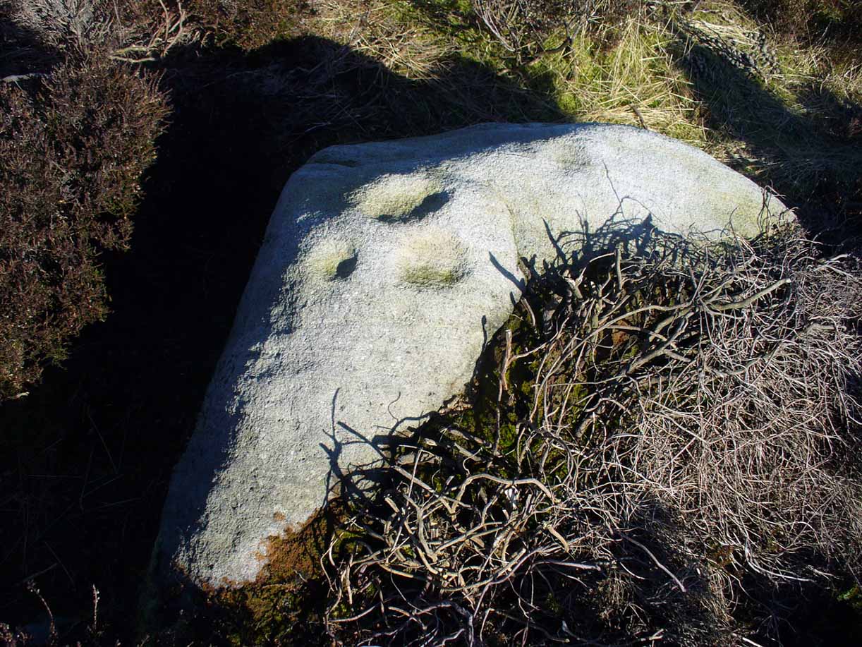
Deer-print motif & cup
Located less than 60 yards (54m) northwest of the impressive Woof Bank enclosure, it’s possible that the first literary note of this was by Stuart Feather (1968) when he made note of five cup-and-ring marked rocks (which) have been revealed by erosion in 1968,” telling us that some of the motifs on the rocks included cups with and without rings, channels and eye-shaped marks (occuli)— the latter of which may relate to this stone.
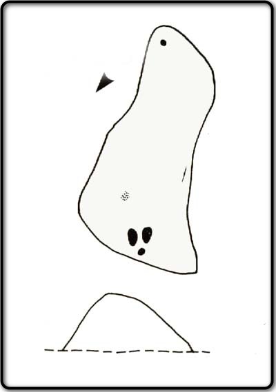
A more definite description of the stone was made in John Hedges (1986) survey where he described it in that usual simplistic form, telling us: “Long rock, its surface on two levels, sloping N to S in heather. Two large oval cups and one cup at N end. One clear cup at S end.”
Hedges’ 1986 sketch
It is these two elongated cups that have the distinct appearance of deer tracks. (another animal with a similar footprint is the goat) The cup-mark in front of them and the one at the back of the rock may be something relative to the animal. But more important than this is to recognise that, in lots of cultures, animal tracks are represented in some petroglyphs. That’s more important to think about when you look at British rock art, than the improbability of this design being such a thing…
References:
Boughey, Keith & Vickerman, E.A., Prehistoric Rock Art of the West Riding, WYAS: Wakefield 2003.
Feather, Stuart, “West Yorkshire Archaeological Register – Ilkley (WR) Green Crag Slack,” in Yorkshire Archaeology Journal, volume 42, 1968.
Hedges, John, The Carved Rocks on Rombalds Moor, WYMCC: Wakefield 1986.
Loendorf, Lawrence L., Thunder and Herds – Rock Art of the High Plains, Left Coast: Walnut Creek 2008.
Schaafsma, Polly, Indian Rock Art of the Southwest, University of New Mexico Press 1980.
Slifer, Dennis, Signs of Life – Rock Art of the Upper Rio Grande, Ancient City: New Mexico 1998.