Go thru Killin and, just past the Bridge of Lochay hotel, take the tiny road on your left. Go down here for 3 miles till you pass the gorgeous Stag Cottage (with its superb cup-and-rings in the field across the road) for another 300 yards, past Duncroisk Farmhouse set back on your right, then over the small river bridge. Just over the bridge there’s a gate on your left. Go thru this and up the track until you get to another large gate. Go thru this, then walk immediately left where you’ll notice a large-ish boulder sat on the nearby slope ahead of you in a part of some very old walling. That’s your target!
Archaeology & History
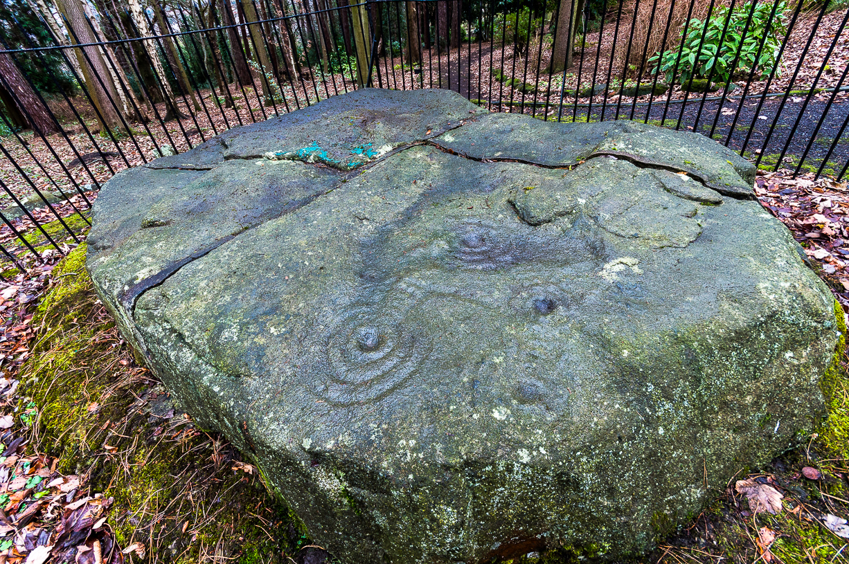
The title of this carving is slightly misleading, as the stone concerned is about 50 yards west of the fast-running burn. But it’s pretty easy to locate. When we visited the stone recently, as the photos show, the rock was all-but covered in a beautiful patchwork of lichen and moss, inhibiting the visibility of a quite impressive carving. But we have to let this be.
The carving’s on the big rock by tree, in the wallingLine of walling clearly evident
The carved rock plays an important part in a line of ancient prehistoric walling, which looks Iron Age in nature, but without an excavation we’ll not know for certain. The walling is quite extensive and is an integral part of the extended derelict village of Tirai, with its standing stones and other monuments. This begs the questions: was the carving executed before or after the walling was created? Was the stone carved in traditional neolithic/Bronze Age periods and later accommodated into the walling?
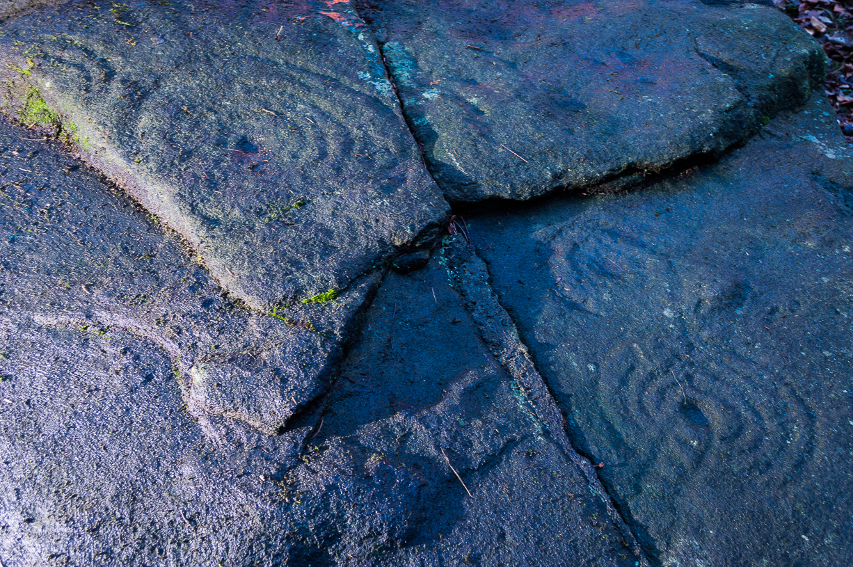
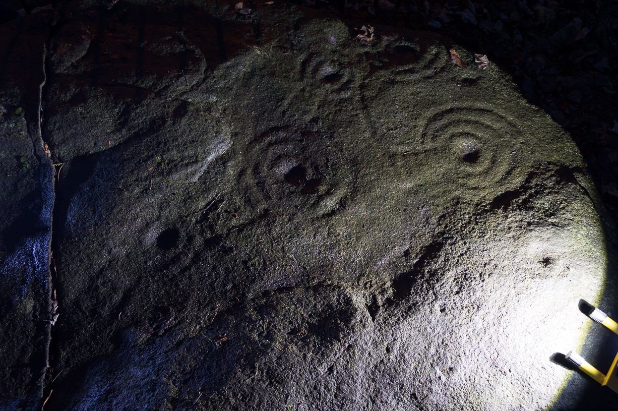
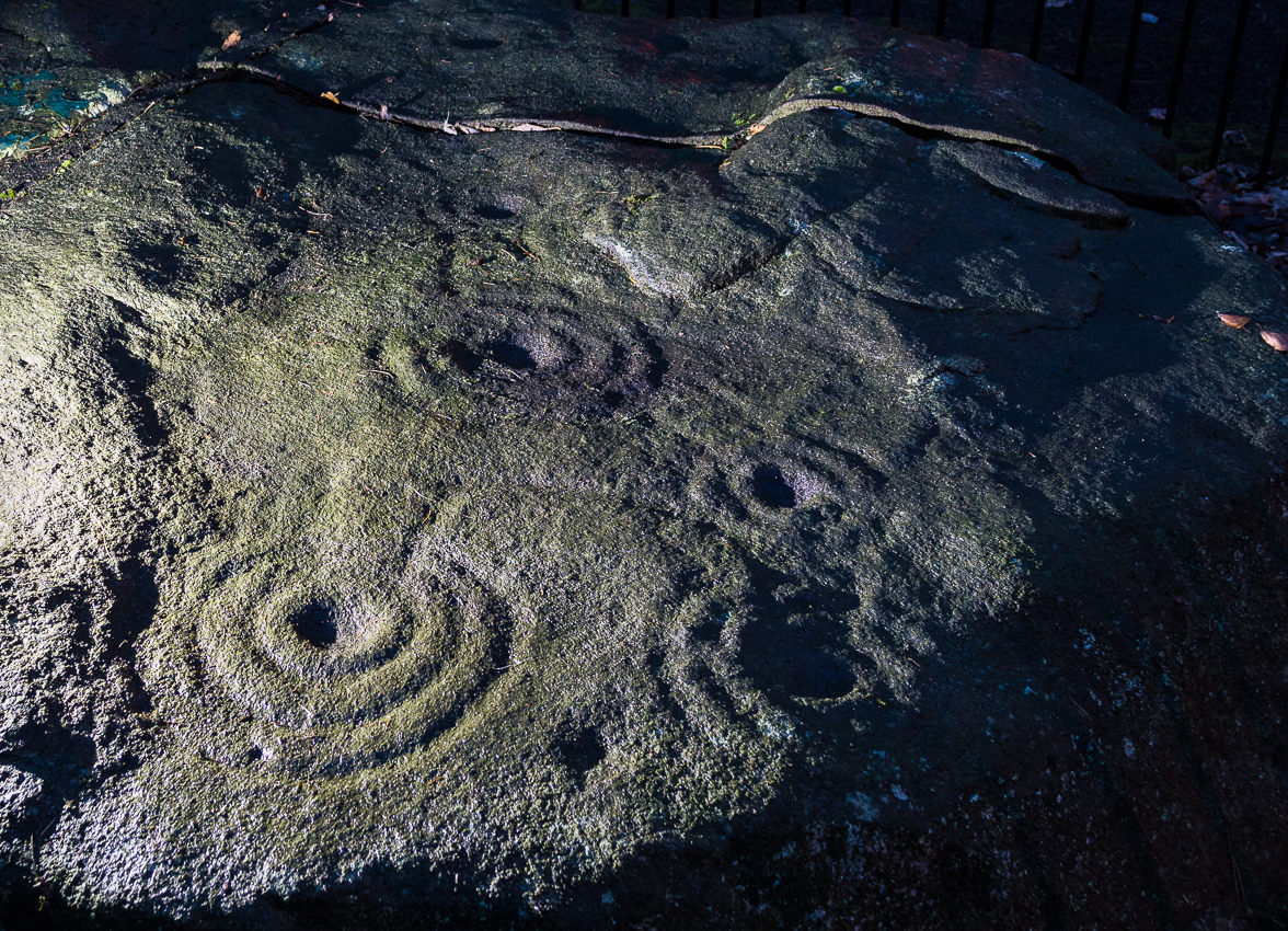
Even in the grey overcast light of a winter’s day when we first visited here, many cups were clearly visible on the rock’s surface, but they were difficult to contextualize in terms of artificial and natural aspects of the stone. Later visits here at the end of Spring enabled a much better assessment — though capturing the surrounding “rings” proved difficult. The carving is shown highlighted on Ron Morris’ (1981) map of the cluster of Duncroisk carvings, and described as a:
“domed schist boulder, 2½m by 2m, 1¼m high (8ft x 6ft x 4ft). On its top, mostly where sloping…are: 2, and possibly 3, cups-and-one-ring, much weathered and only visible when wet in very low sun, probably un-gapped, and at least 32 cups. Diameters up to 17cm (6½in) and depths up to 1cm.”
But this is only half the story. Despite what Mr Morris and the more recent Canmore records tell us about this carving, there are in fact at least 52 cups on the surface of the rock, at least two of which have definite ring-like forms around them. The largest of the cups has linear features around a large section of it, but to ascribe these elements as ‘rings’ is also stretching it a bit — as one of the photos here clearly shows. The ‘ring’ consists more of two separate straight lines with curvaceous ends: more like a right-angled carving with a swerve than any traditional ring. It’s a quite unique feature by the look of things.
Faint cup-and-ring and cups…and…Cups & right-angled lines
The majority of the carved cups and lines occur on the eastern side of the boulder, with only a few singular cups almost fading their way onto its western sloping sides. And of primary visual interest are the swirl of cups that surround two small cups at the ESE corner of the rock. These give the impression of running into another swirl of cups that hedge their ways around the edges of the largest cup-and-right-angled-lines, until bending back up and along the southern-side of the stone. This possibly deliberate sequence of cups then continues in roughly the same form back upwards to near the top-middle of the rock and onto a complete cup-and-ring. Just above the top of this runs a short pecked line just detached from the cup-and-ring, but of obvious mythic relevance in the story which this carving once told.
RWB Morris’ sketch of the design
It’s an absolutely fascinating carving which gives the distinct impression of narrating a myth of journeying, by either a person, tribes or ancestral beings. Of course we’ll probably never know for sure what story it once told; but its tale may have been known by the people of the once proud village of Tirai which was only destroyed a couple of centuries ago, along whose fallen walls this great stone still rests within…
And finally, for those students exploring the potential relationship that cup-and-rings may have with water: please note that in wet conditions, a spring of water emerges right underneath the very base of this large rock.
…to be continued…
References:
Morris, Ronald W.B., The Prehistoric Rock Art of Southern Scotland, BAR 86: Oxford 1981.
Royal Commission on the Ancient & Historical Monuments of Scotland, Archaeological Sites and Monuments of Stirling District, Central Region, Society of Antiquaries of Scotland 1979.
Two real ways to get here. Either (i) follow the directions to get to the Stag Cottage carvings of Duncroisk 1, then walk down to the fence by the riverside and walk along to the left for a coupla hundred yards till you reach a second metal fence-post sticking out of a rock on the other side of the deer-fencing; or (ii) from the roadside burn a coupla hundred yards along the road before you reach Stag Cottage, follow it down to the riverside, then head along the footpath behind the fencing, parallel with the river’s edge. It aint far. Within 100 yards you’ll reach the stone with the metal pole sticking out of it and the carvings are on this!
Archaeology & History
Confusingly redesignated as Duncroisk 5 carving by the usually efficient Canmore people, we’re sticking with this stone’s original name given by Ronald Morris (1981) in his British Archaeological Report of this and nearby carvings — and a quite fascinating carving this is as well!
C.G. Cash’s drawingDuncroisk 3 stone
As with many cup-and-rings, erosion and lighting has a powerful effect on seeing the design correctly. On my visit here in recent months there were quite distinct additional elements in the carving which haven’t been noted by previous archaeologists. But in saying that, there were also some elements that were reported by the earliest antiquarians that proved difficult to see in the grey light of day when I was here. The earliest report of the carving by C.G. Cash (1912) told there to be five rings, whereas today only 3 or 4 are visible (though this will probably change when viewed in other lighting conditions).
When Mr Cash told of this stone in his essay on the antiquities of Killin it sounded as if it was lucky to have survived, as it had previously been dug out and left by the roadside, before then being reused by a local to fix a fence-post in! Mr Cash told us that the local,
“had used it as the foundation stone of the stretching post at the south end of the easternmost fence on the farm, and there I found it, near the brink of the river, buried in sand and turf. I cleared it and then in pouring rain crouched over it to make a hasty sketch. It bears eighteen cups, of which five are surrounded by rings. The largest cups are 2½ inches and the rings 6 inches in diameter.”
Ron Morris’ images
When I visited the place the weather was much the same as Mr Cash described: lovely teeming rain, typical of the mountains, with the surrounding trees breathing moisture onto the slopes as ever.
Years later when Ronald Morris (1981) came here he saw “4 cups-and-one-ring…probably complete rings, up to 12cm (5 in) in diameters and 10 cups up to 2cm deep.”
If you stand and face the stone, the cup-marking on its lower right side (see Morris’ old photo, above) has a pecked line running from it further to the right and down to the edge of the rock. You can clearly make it out on the top photo. This carved line also seemed to touch another carved line which can be seen running along the outer edge of the stone — although the poor light didn’t allow me to view this with absolute confidence. I’ll have another look at it again when I’m up in the area in May and hopefully confirm or deny it with greater confidence (and if anyone else gets here in the meantime, have a look and see what y’ think).
Follow the directions to reach the Herder’s Cross, not far away. Standing on the Herder’s Cross stone, look across the fields to the north (away from the farmhouse on the hill below) and you’ll see a nice-looking stream a coupla hundred yards ahead of you. Crossing this stream you see the large boulder, which you can see clearly if you’re stood on the Herder’s Cross. That’s where you’re heading!
Archaeology & History
A curious entry inasmuch as I’ve found no other references to the place. It’s an obvious cross-base, albeit very worn, cut onto the top of this large boulder, as you can see in the photo. What may be a singular cup-marking (if you’re a New-ager, or work for English Heritage that is!) is on the western side of the rock — but without additional markings on the rock, this has gotta be questionable.
Dodgy cup-marking on top!Shallow cross-base
The cut ‘square’ measures eight-inches both sides, but it seems that the cutting on the north-eastern sides of the base was never finished. The depth of the cross-base is also very shallow, only an inch deep. There seems to be a distinct possibility that this particular stone was initially chosen as a wayside cross marker, then for some reason perhaps moved to the position of the Herder’s Cross in the fields 420 yards (383m) to the south of here.
Clifford Byrne (1974) suggested that the pathway hereby was an ancient routeway that led towards the Emmot Holy Well, three-quarters of a half-mile down the hillside from here. Any further info or thoughts on this side would be most welcome.
References:
Byrne, Clifford, A Survey of the Wayside Crosses in North East Lancashire, unpublished manuscript, 1974.
From Silsden, take the moorland road up to Brunthwaite (ask a local if you’re in doubt). As you get near the top of the moorland road, take the right turn (east) on the track past the Doubler Stones, until you reach the last cottage before the woodland called Black Pots. Go onto the moorland behind the cottage, walking north, crossing the stream and you’ll see a large boulder stuck on its own close by. That’s it!
Archaeology & History
Stuart Feather’s 1964 image
On another wander on these moors t’other day, we ventured to the Doubler Stones and whilst there I had a vague recollection of another decent-looking carving west of them, just above the hidden house at Black Pots, when I was a teenager. When I got home I rummaged through some of my old notebooks and found the drawing I made of it all those years ago. Tis a decent carving consisting of 3 distinct cups encircled, though not completely, in an elongated arc. A cup-and-ring is just above this, and Boughey & Vickerman (2003) highlight another couple of cups which I didn’t manage to see when I was there as a kid. Nor for that matter did Stuart Feather, who was the first person to write about it in the Cartwright Hall Archaeology Group Bulletin in 1964. Itis a good carving in a good spot, with excellent views to the south and west.
References:
Boughey, Keith & Vickerman, E.A., Prehistoric Rock Art of the West Riding, WYAS: Leeds 2003.
Feather, Stuart, “Mid-Wharfedale Cup-and-Ring Markings: no.24 – Black Pots, Silsden, near Keighley,” in Cartwright Hall Archaeology Group Bulletin, 9:7, 1964.
Hedges, John, The Carved Rocks on Rombald’s Moor, WYMCC: Wakefield 1986.
Come out of Ilkley/bus train station and turn right for less than 50 yards, turning left up towards White Wells. Go up here for less than 100 yards, taking your first right and walk up Queens Road until you reach the St. Margaret’s church on the left-hand side. On the other side of the road, aswell as a bench to sit on, a small enclosed bit with spiky railings all round houses our Panorama Stones.
Archaeology & History
J.R. Allen’s 1879 drawing
There were originally ten or eleven carvings that made up what have been called the Panorama Stones and the position they are presently housed in this awful fenced section wasn’t their original home. They used to live a half-mile further up from here, on the moorland edge, just in the woodland at the back of the small Intake Reservoir in the appropriately named Panorama Woods. But in 1890, one Dr. Little — medical officer at Ben Rhydding Hydro — bought the stones for £10 from the owner of the land at Panorama Rocks, as the area in which the stones lived was due to be vandalized and destroyed. Thankfully the said Dr Little was thoughtful and as a result of his payment he had some of the stones saved and moved into the position where they live today. However, as a result of the stones being transported closer to Ilkley, the largest of the carvings was damaged and broken in two pieces on its journey, but the good doctor and his mates restored the rock as best they could before sitting it down in the caged position where it remains to this day.
Thankfully there remain a couple of carved rocks in situ in the trees near where these companions originally came from — though they’re completely overgrown. We uncovered these carvings (one of which was quite ornate) when we were children, but this is now overgrown again and hidden from the eyes of the casual forager. The original position of these carvings was obviously an important feature to our ancestors, but such aspects are of little relevance to industrialists and those lacking sacred notions of the Earth. The same geological ridge on which the Panorama Stones were originally found, stretching west along the moor edge from here, possesses a number of other fascinating carvings, not least of which is our Swastika Stone.
J.T. Dale’s 1880-ish drawingT.Pawson’s late-1870s photo, showing faint ladder marks
It seems they were all first recorded by one J. Thornton Dale, who did some fine illustrations of each stone, which were then collected and organized by a certain Dr. Call of Ilkley in 1880 as a ‘Collection of fourteen drawings of cup-marked rocks.’ These were on file at Ilkley Library (or at least used to be!) and as they’ve not been published previously, I think they need to be retrieved from their dusty shelves and stuck on TNA where they certainly belong! As we can see in Dale’s illustration — etched shortly after the stone was first discovered — much of the detail of the multiple-rings and some of the curious ladder-like motifs were noted (though not all).
Around the same time in 1879, the renowned archaeologist J. Romilly Allen did an early article on the carved stones of Ilkley Moor, selecting the Panorama Stones as one site in his essay. He was very fortunate in getting an early look at the carvings here and gave the following lucid account:
“The Panorama Rock lies one mile south-west of Ilkley, and from a height of 800ft above the sea commands a magnificent view over Wharfedale and the surrounding country. About 100 yards to the west of this spot appears to be a kind of rough inclosure, formed of low walls of loose stones, and within it are three of the finest sculptured stones near Ilkley. They lie almost in a straight line east and west, the first stone being 5ft from the second, and the second 100ft from the third. The turf was stripped from the first a few years ago, and its having been covered up so long probably accounts for the sculpture being in such good preservation. It measures 10ft by 7ft, and is im- bedded so deeply in the ground that its upper horizontal surface scarcely rises above the level of the surrounding heath. The sculpture consists of twenty-five cups, eighteen of which are surrounded with concentric rings, varying from one to five in number. The most remarkable feature in the design is the very curious ladder-shaped arrangement of grooves by which the rings are intersected and joined together. I do not think that this peculiar type of carving occurs anywhere else besides near Ilkley. The second stone is of irregular shape, measuring 15ft by 12ft, and supporting a smaller stone of triangular shape 6ft long by 4ft broad. Both upper and under stone are covered with cups and rings, but the sculptures have suffered much from exposure. The superimposed block has eleven cups, two of which are surrounded by single rings. The under stone has forty-two cups, nine of which have rings. Amongst these are two unusually fine examples, one has an oval cup 5in by 4in, surrounded by two rings, the diameter of the outer ring being 1ft 3in. Another has a circular cup 3in diameter and five concentric rings, the outer ring being 1ft 5in across. The third and most westerly stone of the group measures 10ft by 9ft, and lies almost horizontally, having its face slightly inclined. On it are carved twenty-seven cups, fourteen of which have concentric rings round them. Some of the cups have connecting grooves and three have the ladder-shaped pattern before referred to. Several stones near have cup marks without rings.”
Heywood’s artistic effort!E.T. Cowling’s drawing
When Harry Speight (1900) visited these stones a few years later he echoed much that Romilly Allen had said previously, also commenting on how on certain parts of the carving, “the rings enclosing each cup are connected with ladder-like markings.” (my italics, PB) These “ladders” were even mentioned in a speculative but inaccurate essay by Nathan Heywood (1888) in a paper for the Lancashire and Cheshire Antiquarian Society. Equally important was a description of the site when members of the Yorkshire Archaeological Society visited the Panorama Stones in 1884, and Rev. A.C. Downer (1884) described this “most important group” of stones, saying that
“Near the Panorama Rock are three large masses of ironstone close together, and averaging ten to twelve feet across each way, the horizontal surface of which are covered with cups and rings, and two of these stones have also a peculiar arrangement of grooves somewhat resembling a ladder in form.”
Modern Folklore
Despite this and other descriptions, in recent times local archaeologist and rock art student Gavin Edwards has propounded the somewhat spurious notion that the ladders and perhaps other parts of the Panorama Stone carvings have a recent Victorian origin, executed by a local man by the name of Mr Ambrose Collins. Edwards took this silly idea to the Press, thinking he’d found something original, following a recovery of some notes from the Ilkley Gazette newspaper (earlier archaeologists had already explored this, which he should have been aware of), in which was stated that the said Mr Collins told other people in the Ilkley area that he was carving some of the old stones on the moors nearby. Now we know that Collins did this (we have at least 3 examples of his ‘rock art’ in our files), but he wasn’t allowed to touch the Panorama Stones!
Panorama Stone 229 (by James Elkington)Close-up of multiple rings (by James Elkington)
However, despite Gavin Edwards’ theory, it is clear that Ambrose Collins was not responsible for any additional features on the Panorama Stones: an opinion shared by other archaeologists and rock art specialists. Edwards’ theory can be clearly shown as incorrect from a variety of sources (more than the examples I give here).
In no particular order…there was an early photo of the main stone (above), taken sometime in the late-1870s by Thomas Pawson of Bradford which shows, quite clearly, some of the faded “ladder” motifs on the rock in question while the stone was still in situ. There is also an additional and important factor that Edwards has seemingly ignored, i.e., that neither J.Romilly Allen, Harry Speight, members of the Yorkshire Archaeological Society, nor any of their contemporaries made any comments regarding additional new motif elements carved onto these rocks when they visited the carvings at the period Edwards is suggesting Collins did his additions — which such acclaimed historians would certainly have mentioned. Mr Edwards theory, as we can see, was a little lacking in research. Considering only these small pieces of evidence, the pseudoscientific nonsense of the Victorian carving theory can safely be assigned to the dustbin!
Close-up of faint ladders (by James Elkington)Close-up under lighting (by James Elkington)
If however, we do use Mr Edwards’ reasoning: take a look at the modern “accurate” drawing of this carving in Boughey & Vickerman’s (2003) book—which actually, somehow, misses elements of the carving that are clearly shown in Mr Pawson’s 1890’s photo and are still visible to this day! What are we to make of that? Have these modern folk been at it with the sand paper!? We can only conclude that these simple errors show a lack of research. The most worrying element here is that a local archaeologist can make such simplistic errors in his analysis of prehistoric and Victorian carvings without checking over publicly accessible data. Even more disconcerting was the fact that he was running Ilkley’s local prehistoric rock art group!
However, we cannot dismiss out of hand the words of the said Ambrose Collins in his proclamation of carving stones on the moors, as there is clear evidence that he did a replica of the Swastika Stone on rocks near the original site of the Panorama Stones. The carving he did is very clearly much more recent. We have also found one carving with Collins’ initials — ‘A.C.’ — carved on it and the date ‘1876’ by its side.
And although we can safely dismiss the Edward’s Theory about the Panorama Stones “ladders”, we may need to reconsider a number of other carvings on Rombald’s Moor as potentially Victorian in nature using the rationale Edwards proclaimed. For example — and using the disproved Edwards Theory — when we look at Romilly Allen’s drawing of the famous Badger Stone (from the same essay in which his image of the Panorama Stone is here taken), much of the carving as it appears today was not accounted for in the drawing. We can also look selectively at many other cup-and-rings on these moors and find discrepancies in form, such as with the Lattice Stone on Middleton Moor, north of Ilkley, or the eroded variations on the Lunar Stone. We have to take into consideration that some may have been added to; but more importantly, we must also be extremely cautious in the movement between our idea and the authenticity of such an idea. It is a quantum leap unworthy of serious consideration without proof. (though the example of the Lattice Stone has a markedly different style and form to the vast majority of others on the moors north and south of here. Summat’s “not quite right” with that one and the comical Mr Collins might have had his joking hands on that one perhaps…)
One very obvious reason that a number of the cup-and-ring carvings were not drawn correctly by historians and archaeologists alike, would be the weather! Archaeologists are renowned for heading for cover when the heavens open, quickly finishing their jottings and running for cover — and this would obviously have been the case with some of the drawings, both early and modern. Bad eyesight and poor lighting conditions is also another reason some of the carvings have been drawn incorrectly, as a number of modern archaeology texts — including a number in Boughey & Vickerman’s (2003) book — illustrate to all competent students.
There is still a lot more to say about this fascinating group of carvings, which I’ll add occasionally as time goes by. And if anyone has any good clear photos of the stones showing the intricate carved designs that we can add to this profile, please send ’em in (all due credit and acknowledgements will be given).
References:
Allen, J. Romilly, “The Prehistoric Rock Sculptures of Ilkley,” in Journal of British Archaeological Association, volume 35, 1879.
Bennett, Paul, The Panorama Stones, Ilkley, TNA: Yorkshire 2012.
Boughey, Keith & Vickerman, E.A., Prehistoric Rock Art of the West Riding, WYAS: Leeds 2003.
Cowling, Eric T., Rombald’s Way, William Walker: Otley 1946.
Downer, A.C., “Yorkshire Archaeological and Topographical Association,” in Leeds Mercury, August 28, 1884.
Hadingham, Evan, Ancient Carvings in Britain, Souvenir Press: London 1974.
Hedges, John, The Carved Rocks on Rombald’s Moor, WYMCC: Wakefield 1986.
Heywood, Nathan, “The Cup and Ring Stones of the Panorama Rocks”, in Trans. Lancs & Cheshire Anti. Soc.: Manchester 1889.
Hotham, John Paul, Halos and Horizons, Hotham Publishing: Leeds 2021.
Speight, Harry, Upper Wharfedale, Elliott Stock: London 1900.
Acknowledgements: Huge thanks to the staff at Ilkley Library for their help in unearthing the old drawings and additional references enabling this site profile.
To be found a couple of hundred yards west of Askwith Moor Road, head towards the bottom of the row of grouse-butts, following the fence that runs into the moorland across from the dusty car-park.
Archaeology & History
Single cup-marked stone
This single cup-marked stone — list as carved stone no.529 in Boughey & Vickerman’s (2003) survey — was reported when some English Heritage doods came here and found this small upright stone (probably part of a larger prehistoric monument, e.g., walling or cairn) and gave the cup-marking their “all clear” stamp and thought it authentic. But if memory serves me right (which it doesn’t always do these days!), I’m pretty sure Graeme Chappell came across this possible carving in the early 1990s during one of our many forays over these moors. It’s a cute little thing — though only for the purists amongst you perhaps — but, of course, needs to be seen in the context of its proximity to the many other prehistoric monuments across this moorland plain.
References:
Boughey, Keith & Vickerman, E.A., Prehistoric Rock Art of the West Riding, WYAS: Wakefield 2003.
Many churches strive to find evidence in the greater antiquity of their foundations than the industrial age; and even those whose origins are medieval hope to find much older roots. Such is the case with this Norman church of St. Peter, where just such an antiquity was found in the middle of the 19th century, embedded in the old walling where it had been encased many centuries before. Thought to have been carved around the 8th century, the design on the stone typifies much ‘Celtic’ art, as it tends to be called, such as are found all over northern England. As we can see here, the main feature is a series of curved and interlocking lines covering most of the rock face (sadly, no swastika occurs on this stone, but it’s common on many others of this period). The old vicar of the church — Harold Rogers — takes up the story:
“About the year 1841, when part of the chancel work was taken down, some fragments of curiously ornamented sandstone were discovered embedded in the masonry. They were carefully removed, put together, and placed in the churchyard where, protected from injury by a glass case, they may now be seen. The carved ornamentation on this ancient relic was probably executed about the 8th century, and it is conjectured that the stone formed part of a cross placed there by some early Saxon converts…to commemorate the spot where the gospel was first preached in this locality.”
A brass inscription attached to the encased carved stone informs the visitor the same information. The proximity of this early carved stone to the River Bollin and, very probably, an ancient ford crossing, implies the waters here were held as sacred in ancient days and hence the supplanting of the ornate carved cross at this position in the landscape.
References:
Rogers, Harold W., Prestbury and its Ancient Church, Arthur Clownes: Macclesfield n.d. (c.1960)
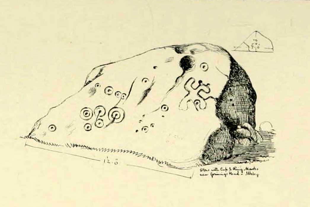
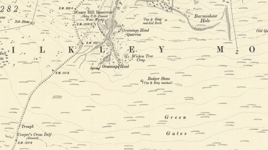
Although there are several routes to this site, for those who are not used to walking or find maps difficult to read [get a life!], it is best approached from the Ilkley side of the moor. Follow the old track that cuts the moor in half past the remains of Graining Head quarry where the moor begins to level out. Once here cut straight east until you find the footpath which, after a while, you will see leads to a wooden seat right in the middle of nowhere. Here is our Badger Stone.
Archaeology & History
An eroded but quite excellent cup-and-ring stone — one of the very best on Ilkley Moor — comprising nearly a hundred cups, ten rings, what seems to be a half-swastika design, plus a variety of other odd motifs. It’s one of the best carvings on the entire moor and has been written about by many folk over the years. First described in an early essay on cup-and-ring stones by J. Romilly Allen (1879) — who must have visited it in poor light, as some elements of the carving weren’t noticed — he described it as a “sculptured stone near Grainings Head”, saying:
“This stone…is a block of gritstone 12ft long by 7ft 6in broad, by 4ft high. The largest face slopes at an angle of about 40° to the horizon, and on it are carved nearly fifty cups, sixteen of which are surrounded with single concentric rings. At the west end of the stone are a group, three cups with double rings and radial grooves. At the other end, near the top, is a curious pattern formed of double grooves, and somewhat resembling the “swastika” emblem… At the highest part of the stone is a rock basin 8in deep and 9in wide. On the vertical end of the stone are five cut cups, three of which have single rings. This is one of the few instances of cup and ring marks occurring on a vertical face of rock.”
Badger Stone on 1910 map
The title “badger” dates back to at least medieval times when, as the Yorkshire historian Arthur Raistrick (1962) explained, the word represented “a corn dealer, corn miller or miller’s man.” It is likely that this traditional title goes much further back, probably into prehistory, as grain was one of the earliest forms of trade. Very close to this sacred old stone are place-names verifying this, like Grainings Head and Green Gates. A little higher upon the moor is the twelfth century Cowper’s Cross (which used to have cup-markings etched upon it) where, tradition tells, a market was held that replaced an older one close by.
The Badger Stone carvingClose-up of cup-and-rings
Our Badger Stone rests beside the prehistoric track which Eric Cowling termed “Rombald’s Way” (after the legendary giant, Rombald, who lived with his old wife upon these hills): an important prehistoric route running across the mid-Pennines. This ancient route runs east-west, traditionally the time of year when agricultural needs are greatest at the equinoxes. This may have been the time when any ancient grain traders met here. (In modern times a number of archaeologists have emphasized such routes as “trade routes”: a notion that derives from the modern religion of Free Market Economics in tandem with the rise of Industrialism and social Darwinism, much more than the actuality of them as simple pathways or means of accessible movement).
There are accounts from other places in Yorkshire about these badger men. We find a number of other “badger” stones, gates, ways, stoops and crosses on our Yorkshire hills. One of them in North Yorkshire, wrote Raistrick (1962), “is an ancient trade way.” In Richmond, North Yorkshire, around the time of the autumn equinox, Badger men from across the Dales followed the old routes over the hills into town, held annual festivities and sold their grain. (see Smith 1989; Speight 1897) It is perhaps possible that our old Badger Stone would have been a site where some form of indigenous British Demeter was revered.
Sketch of Badger Stone carving
Some elements of the Badger Stone carving have what could be deemed as primitive human images (anthropomorphic) mainly on the northwestern side of the rock, emerging from the Earth Herself. And certainly amidst the same portion we have a very distinct ‘solar’ symbol, very much like the ones found at Newgrange and, for that matter, many other parts of the world.
Some New Age folk have given the fertility element to the Badger Stone a deeper status, using imagination as an aid to decode these old carvings. When feminist New-Age writer Monica Sjoo visited Badger Stone she described it as “erotic”, with the carvings giving her a distinct impression of “vulvas” and she also thought orgies of sorts had been enacted here. (Billingsley & Sjoo, 1993) The vulva imagery is a well-known idea to explain cup-and-rings and in some cases this will be valid; but when I passed an illustration of this rock-art to a number of people (all women), there was not a vulva to be mentioned — merely the OM symbol, sperm entering the egg, a snail, a bicycle, a willy, a paw-print, eyes, a face, a tadpole, cartoon breasts, the rear end of a dog, grapes, letters, numbers, ears and a snake! Awesome stuff! Take a look at the design yourself and see what you can see in it. Answers on a postcard please! (The dilemma of making specific interpretations of these carvings is that we tend to approach them with dominant ego perspectives, many of them reflecting little more than our own beliefs or search for identity, imposing unresolved journeys and conflicts on that which we encounter, as with the above case.)
As with prehistoric rock-art in general, they are a number of things: functional, ritual, history, spirit; different at each and every site. As if to exemplify this at Badger Stone, note how the detailed carvings have been executed mainly on the southern face of the stone. The northern face has little if anything to show on it. It would suggest therefore, that this stone had some mythic relationship with events during daylight hours. But we have to be careful here…
At sunrise on a good morning, we note how the eastern edges of this stone show up very clearly indeed. If Nature’s conditions are damp and wet (as they tend to be each morning on the hills), the visible outline of these cup-and-rings show up very clearly indeed. Oddly, as the sun then passes through the daytime sky each and every day on its cyclical movement, the petroglyphic content becomes a little less visible unless the stone is wet. Indeed at sun-high (midday period) the carving doesn’t show up as well as it did in the morning light. And we find the same characteristic as the sun goes to set in the west: where that part of the carved stone shows up very clearly again — much clearer than during full daytime hours. If rain has fallen, the glyphs stand out very clearly indeed.
As all cultures imbued the natural world with animistic, living qualities, it seems probable that these periods of the day (sunrise and sunset) were significant at this particular carving. It may be, very simply, that the Badger Stone “came to life” with the sunrise and its mythic nature was alive during this period; whereas with many other carvings (both on these moors and elsewhere in Britain) their strong mythic associations related to the northern Land of the Dead. But then, I could be talking bullshit!
The Badger Stone is also a strong contender for it being a painted stone. Many petroglyphs like this in other cultures were ceremonially coloured-in using lichens and other plants dyes at certain times of the day or year, relating specifically to important mythic relationships between the people and the spirit of the rock at such places. This probably occurred here.
References:
Allen, J. Romilly, “The Prehistoric Rock Sculptures of Ilkley,” in Journal of the British Archaeological Association, volume 35, 1879.
Bennett, Paul, The Old Stones of Elmet, Capall Bann: Milverton 2001.
Billingsley, John & Sjoo, Monica, “Monica Sjoo in West Yorkshire,” in Northern Earth Mysteries, no.53, 1993.
Boughey, Keith & Vickerman, E.A., Prehistoric Rock Art of the West Riding, WYAS: Leeds 2003.
Hedges, John, The Carved Rocks on Rombald’s Moor, WYMCC: Wakefield 1986.
Cowling, Eric T., Rombald’s Way, William Walker: Otley 1946.
Raistrick, Arthur, Green Tracks on the Pennines, Dalesman: Clapham 1962.
Smith, Julia, Fairs, Feasts and Frolics: Customs and Traditions in Yorkshire, Smith Settle: Otley 1989.
Speight, Harry, Romantic Richmondshire, Elliot Stock: London 1897.
Walk about a mile along West Lane from Askwith village, towards Ilkley, until you reach a notable rounded bend in the road where, in the field immediately above you (behind the thorns) on your left, is a small scatter of large rocks at the edge of the field. One of these is what you’re after! (although this stone is just a couple of yards from the roadside, you can’t just pull up here and have a look — unless you’re an idiot! — without causing one hellova bad accident. So don’t do it!)
Archaeology & History
Carving no.509, Askwith
First described in Boughey & Vickerman’s (2003) survey, this is a curious “design” — if indeed that’s the right word! On the upper surface we can see, very clearly, one large cup and two deep curved lines set away from the cup-marking. One of these lines appears to curve along and down the edge of the rock and, on the shaded side below (somewhat overgrown with nettles when we were looking at it), what may be another large cup-mark and a continuation of the same “carved” line, roughly as drawn in the 2003 survey. It looks pretty good (if you’re a sad rock-art freak like me), but there could be another reason for the markings…
A mile upstream on the eastern edges of the wooded Scales Gill valley (known in previous centuries as both St. Helen’s Ghyll and the Fairy Dell), recent forestry and industrial work has scarred a number of rocks with engraved lines upon more faded cups or gunshot marks. When we wandered up here a few days ago and found a couple of these recently scarred stones, I remarked on how, in years to come, unless we made note of these very modern curves and grooves on the rocks, that future archaeologists will be cataloguing them as cup-and-ring stones. Several hours later on the way back home from our moorland wanderings, we ventured upon this, stone no.509.
I mention this for good reason: as a century back, only 100 yards away, are the remains of what was an old quarry that used industrial machinery similar to the ones that have made the recent curved markings on the stones a mile up the valley. And as we can see quite clearly with this stone and its companions, they’ve been moved and dumped into their present position at the field-side. We should keep this ingredient in mind when looking at this stone, just in case the archaeologists who’ve logged this as prehistoric have got their dates out by a few thousand years. With any luck however, I’ve got it all wrong…
References:
Boughey, Keith & Vickerman, E.A., Prehistoric Rock Art of the West Riding, WYAS 2003.
From East Morton village, take the moorland road, east, and up the steep hill. Where the road levels out there’s a right turn, plus (more importantly!) a trackway on your left which leads onto the moor. Go up this track for a few hundred yards until you’re on the moor proper (by this I mean the track’s levelled out and you’re looking 360° all round you with all the moor in front of you). Just before the track starts a slight downhill slope, go into the heather on your right, for about 80 yards. You’re damn close!
Archaeology & History
I first came here many years back in my mid- to late-teens with an old school-friend Jon Tilleard, wandering about adventurously, occasionally stopping here and there when I found some stupid cup-mark or other seemingly innocuous scratch on the rocks, gerrin’ all excited and jumping about like a tit! But when we visited the place again a few days back my response was somewhat different. I was worse! But for good reason…
Primary features of CR-107Close-up of main features
The potential variations visible in this carving are peculiar, to say the least. Ones first impression shows a carving similar in many ways to that shown in Hedges (1986) fine survey; but upon closer inspection a number of initial visual responses begin to look murky. A seeming cup-with-double-ring aint what it seems! To me at least (sad fella that I am!), it’s far more intriguing and far less certain, with a number of oddities still left.
The central feature of the carving is the lovely near-cup-and-double-ring! As we can see in the photo here, there are some insecurities in the top-right of the outer ring. To the upper right of this is another cup-with-partial-ring that was not included in the Hedges (1986) survey, nor Boughey & Vickerman’s (2003) updated work. There are some obvious pecked carved lines — whose specific definition yet remains unclear — in and around this area of the petroglyph; but in the “official” illustration these elements or ingredients were somehow missed.
Eclipse Stone, looking west
When we visited the stone the other day, the naturally eroded lines on the rock seemed pretty obvious; but the more we looked, the less secure we were about some of them. Thankfully the light kept changing about, allowing us to get different perspectives — and with the low sunlight of evening casting itself across the rock, some additional features seemed obvious. In particular, what seemed like two natural “scratches” on the stone turned out to have been pecked and carved and the straight lines ran into the double cup-and-ring on the left-side. One of these — the lower and shorter of the two — seems to run into the central cup, but this aint certain. The longer top line has an even more circuitous venture: entering the outer ring, it passes onto the top-inner ring and then bends along its edge, before exiting again on the right-hand side, through the outer ring and heading out towards the large natural eroded cutting a few feet away (see my crappy drawing to get an idea). Other faint aspects on this stone may have the hand of man behind them…
My shit sketch!Hedges 1986 sketch
There are certainly a few other cups on the stone: one with a near semi-circle on its lower and right-hand side. The long nature-worn cut, right-of-middle, may have had the hand of man cutting into the cup at the bottom; and another couple of “is it? — isn’t it?” enhanced natural cups seem possible on the left side of the rock. There is also what looks like a distinct single cup-marking on the west-facing vertical face of the stone (you walk towards it from the track). It looks pretty decent, but I’ll let them there “professionals” assess the validity or otherwise of that one! But the other unmistakable and very curious ingredient is the deep, worn arc beneath the primary double-ring feature. This is, as the photo shows, separated by a long natural crack running halfway down and along the stone, above which possibly the double-ring feature touches. This large ‘arc’ feature gives the distinct impression of being a big smile! However…
Turn the image of the central feature upside down and you get a very different effect indeed. A rainbow above the surface of the Earth, with (perhaps) a pool in which the sun has reflected? Or an underworld venture? Looking at it from a few angles gives the impression of a comet moving across the sky, aswell as an eclipse with the diamond-ring effect. But as with cup-and-ring in general, there are plenty of other potentials! Which also begs the question: was it to be looked from the top or bottom (or left or right for that matter)?
I could waffle about this particular carving for much longer, showing that it had quite an effect on me. Check it out and sit with it for a while… It’s superb!
References:
Boughey, Keith & Vickerman, E.A., Prehistoric Rock Art of the West Riding, WYAS 2003.
Hedges, John (ed.), The Carved Rocks on Rombalds Moor, WYMCC: Wakefield 1986.


")
")
")

")
")