West Agra Plantation 2b, Colsterdale, North Yorkshire

Cup-Marked Stone:  OS Grid Reference – SE 14126 81669

Also Known as:

  1. WAP 2b (Brown & Brown)

Getting Here

West Agra Carving 2b

From Masham, take the Fearby Road to the village, keep going on the same road through Healey village and less than a mile on where the road forks, bear to the right past and go along the gorgeous little-known vale of Colsterdale.  It’s bloody beautiful!  Less than 2 miles on, walk up the notable track veering to your right that goes diagonally uphill and past the bottom of West Agra farm along the wallside till you get to the gate.  Thru the gate, follow the wall immediately uphill to the right for a coupla hundred yards until you reach a gate into the field on your right.  The cluster of large boulders in front of you is where you need to be!

Archaeology & History

Cluster of cups on WAP-2b (image by ‘QDanT’)

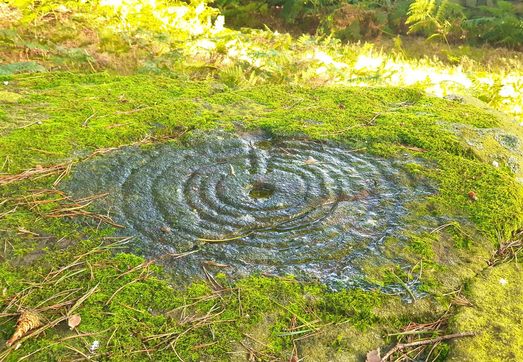
This carving is to be found on the largest of the boulders in this cluster.  It’s a large scattered cluster of cup-markings and natural bowls all over the rolling surface of the rock.  It was first described in the Browns’ (2008) survey, although as they have given this and one of the adjacent stones incorrect grid-references, it made it troublesome to initially work out which carving was which!  But the photos here certainly lets you know which one I’m describing!  In the event that I’ve got the wrong title for this one, someone lemme know and I’ll remedy the situation!

Brown (2008) describes this design as being “cups some linked by grooves, a rectangular feature and eroded cups and depressions.”  We couldn’t work out any further elements on the stone, but the cloudy conditions when we were here prohibited a decent view of the surface.

References:

  1. Brown, Paul & Barbara, Prehistoric Rock Art in the Northern Dales, Tempus: Stroud 2008.

Links:

  1. Agra Wood Rock Art – more notes & images

© Paul Bennett, The Northern Antiquarian


West Agra Carving, Colsterdale, North Yorkshire

Cup-Marked Stone:  OS Grid Reference – SE 14069 81627

Getting Here

Cup-marked stone near West Agra

From Masham, take the Fearby Road to the village, keep going on the same road through Healey village and less than a mile on where the road forks, bear to the right past and go along the gorgeous little-known vale of Colsterdale.  It’s bloody beautiful!  Less than 2 miles on, walk up the notable track veering to your right that goes diagonally uphill and past the bottom of West Agra farm along the wallside till you get to the gate.  Thru the gate, follow the wall immediately uphill to the right and, about 100 yards up, watch out for the large flat stone by the side of the footpath.  You can’t really miss it.

Archaeology & History

Initially we thought that this carving was one described in Paul Brown’s work as ‘West Agra Plantation no.1’, but this is clearly a different carved stone.  It is found close to WAP-1 (as he called it), but a few yard further up alongside the footpath by the walling.  With two large bowls on the top of the stone and another at the edge, two average-sized cup-markings are several inches away to the bottom-right of the largest bowl.  What seems to be a carved line runs from one of the cups.  We need to visit this stone again and look at it when there’s better lighting conditions so we can get a more accurate assessment of its nature.

References:

  1. Brown, Paul & Barbara, Prehistoric Rock Art in the Northern Dales, Tempus: Stroud 2008.

Links:

  1. Agra Wood Rock Art – more notes & images

© Paul Bennett, The Northern Antiquarian


Maen Achwyfan, Whitford, Flintshire

Cross: OS Grid Refence – SJ 129 788

Also Known as:

  1. The Stone of Lamentation
  2. St Cwyfan’s Stone

Getting Here

Maen Achwyfan Cross (after J.O. Westwood)

Go north on the A5026 from the town of Holywell for about 3 miles; at the hamlet of Lloc take the turning first right towards Trelogan village for another mile – the ancient cross stands in the corner of a field at the junction of 3 roads at the turning from Whitford to Trelogan, halfway between Whitford and Sarn. The cross can also be reached via Pantasaph from the A55.

History

The cross probably dates from 1000 AD and is said to be the tallest wheel-headed cross in Wales, standing at 11 feet 3′ in height. The metal fence surrounding the cross spoils the monument quite a bit, but it is there for security reasons.  It is richly decorated on all sides and on the cross-head. Much of the decoration is Celtic in origin, but there are also Viking influences here, probably Northumbrian. On the south face there is a human figure standing on a serpent that has associations with the Norse god Odin; also a three-legged horse that may also be connected to Odin. The north-west face has Celtic pattern-work in the form of the letter “X” and below that another figure (naked) holding a spear. The north-east face is rather eroded, but there is some Celtic-style decoration. There is more knotwork and chainwork elsewhere on the cross with other animal figures.  The wheel-head has a distinctive central boss and a four star-shaped cross radiating from the boss.

Folklore and Legend

The cross is also called ‘The Stone of Lamentation’ because penances were carried out at the cross in the Middle Ages. This act would have concluded with weeping and the ‘act of contrition’ by pilgrims visiting the site whilst making their way between St Winifred’s Well and St David’s.  Legend says that St Cwyfan, a local 7th century Celtic saint preached on this site and set-up the cross – hence the name, Maen Achwyfan.  One local legend tells us that Queen Boudica fought her last battle against the Romans close by in the fields called ‘Cydio ar Leni’ or ‘The fields of the seizing legions’.  During the Middle Ages the monks of Basingwerk Abbey preached at the cross and also set up a chapel for pilgrims just to the south at Whitford.

References:

  1. Allen, J. Romilly, “Celtic Crosses of Wales”, in Archaeologia Cambrensis, 1899.
  2. Owen, Rev. Elias, Old Stone Crosses of the Vale of Clwyd and Neighbouring Parishes, Bernard Quaritch: London & Oswestry 1886.
  3. Sharkey, John, Celtic High Crosses of Wales, Carreg Gwalch: Llanrwst 1998.
  4. Westwood, J.O., Lapidarium Walliæ – The Early Incised and Sculptured Stones of Wales, Oxford University Press 1879.

Copyright © Ray Spencer 2011


West Agra Plantation (8), Colsterdale, North Yorkshire

Cup-and-Ring Stone:  OS Grid Reference – SE 14250 81756

Also Known as:

  1. WAP 8 (Brown & Brown)

Getting Here

The ‘West Agra 8’ Stone (after ‘QDanT’)

From Masham, head westwards along the country lanes to Fearby village (passing the old cross on the green), through old Healey village (where once stood four stone circles, seemingly destroyed) and onwards to Gollinglith.  From here, keep going up the winding steep lane until you’re at the top where, on the right-hand side of the road, a footpath takes you diagonally northwest over the uphill fields.  When you hit the walling which leads to the woods, follow it up and, once at the corner of the trees, follow the track back eastwards along the wall edge, keeping your eyes peeled when you pass the second line of walling that runs down the slope.  You’re damn close!

Archaeology & History

One of a cluster of fascinating carvings in this remote region of the upland Dales, this is perhaps the most impressive multiple-ringed carving of the group, known collectively as the West Agra Plantation group.  The carving was rediscovered sometime in 2002 by Emily McIntosh and was described by Brown & Brown (2008) thus:

“This boulder measures 5.5 x 3.1 x 1.28m and has a multiringed motif 50cm in diameter linked by a number of grooves and isolated cups.”

Teddy with his rings! (after ‘QDanT’)
Primary cup-and-multiple-rings (after ‘QDanT’)

But this barely does the stone justice.  The main focus is on the cup with six surrounding rings, intersected by an intrusive double-line from outside the series of rings then running into the central ring itself — though not touching the focal cup at the very centre.  This double line points to the southeast and is somewhat akin to a sliver of light running to or from old solar designs.  It is a little bit like some aspects of the carved stones found on Ilkley’s Panorama Stones (though Ilkley’s carvings are much fainter).  At the end of the intrusive double-line is a small cluster of cup-marks.  There’s also another curious singular carved line running outwards from the third ring, running out of the concentric rings then heading off further down the stone.  More cups and lines scatter other parts of the stone and there may be another faint line running from near the central cup all the way out of the rings close to the main ‘ray’ of lines.

Photo by Geoff Watson

A large standing stone can be seen if you walk a few hundred yards east along the side of the wall.  It’s quite impressive.

Apparently the woodland in which this carving (and its associates) can be found is supposedly ‘private’ and one is supposed to contact some group calling itself Swinton Estates to set foot in the woods.  Not the sort of practice we usually put up with in Yorkshire.  If anyone has their contact details, please add them below in the event that anyone has need to ask ’em about going for a walk here.

References:

  1. Brown, Paul & Barbara, Prehistoric Rock Art in the Northern Dales, Tempus: Stroud 2008.

Links:

  1. Agra Wood Rock Art – more notes & images

AcknowledgementsFor use of their photos, many thanks to Geoff Watson; and QDanT and his Teddy!

© Paul Bennett, The Northern Antiquarian


Solar Stone, Askwith Moor, North Yorkshire

Cup-and-Ring Stone:  OS Grid Reference – SE 17738 51003

Also Known as:

  1. Carving no.567 (Boughey & Vickerman)
  2. TV Stone

Getting Here

Stone at cairn edge

From the scruffy Askwith Moor lay-by car-park, along Askwith Moor road, follow the fence north up along the roadside until you reach the gate on your right.  Go thru this and head due west into the moor, towards the small cluster of other carved stones (carvings 581, 582, etc), particularly the Small Rings Stone (carving 579).  Around here, you’ll notice a cluster of about 10 mounds in the heather, which seem to be prehistoric cairns, and this particular stone rest against the northwestern side of one of them, about 30 yards west of carving 579.  If you’re patient, you’ll find it! (if you fancy a look at all these on the moor, gimme a shout & I’ll take you straight to ’em – but you need to make a booking!)

Archaeology & History

This carving takes a bitta finding amidst the mass of deep heather and open moorland and is probably only gonna be of interest to real cup-and-ring fanatics.  But it’s the setting which makes it more intriguing — for me anyhow!

Trying to highlight the internal CnR
Solar Stone carving

Like other carvings on this moorland, we find it in direct association with a prehistoric tomb (though it aint been excavated), resting up against the edge of one.  However, it seems to have been moved from its original position and may, perhaps, have actually faced the other way at some time in the past.  We might never know.  However, some student in the recent past saw fit to name this small carving the ‘TV Stone’, thanks to the slightly cronky outline of an old television screen, with its small half-cup-and-ring near the bottom corner of the rock.  You can see where they were coming from!

Boughey & Vickerman (2003) made only a brief note of the stone, seeing only the cup-and-half-ring here; but there seems to be a faint cup-marking near the middle of their TV screen, along with faded evidence of an incomplete ring around it.  You can just about make it out in the poor photos we took of it. (sadly, we were without water when we visited it, which would have highlighted the additional cup-and-slight ring more clearly)

Close-up of cup-and-half-ring

We gave this stone the title ‘Solar Stone’* as it seems more appropriate and would certainly have more mythic relevance to the people who carved this.  The curious natural ring, or TV outline, running round most of the stone (with the faded cup-and-part-ring near its centre) may have been attached with more animistic attributes than us moderns tend to give things — children notwithstanding!  Circular forms in Nature have universal tendencies in more traditional cultures with such heavenly bodies as sun or moon, which might have been relevant here with the stones association with a tomb.

…Again, we might never know…

References:

  1. Boughey, Keith & Vickerman, E.A., Prehistoric Rock Art of the West Riding, WYAS: Wakefield 2003.

* though did debate in somewhat primitive northern lingo: “Ugh – errr…solar? lunar? Ey? — Solar? Lunar?” uttering the same queried mantra numerous times between ourselves till we got tired and stuck with ‘solar’, as seems common these days (though I preferred ‘lunar’, it’s gotta be told!).

© Paul Bennett, The Northern Antiquarian


Monzie Carving, Crieff, Perthshire

Cup-and-Ring Stone:  OS Grid Reference – NN 88161 24176

Getting Here

Andy Finlayson’s original piece

From Gilmerton village, take the A822 Dunkeld road north.  Go for about 200 yards and take the little road to Monzie; watching carefully another 200 yards on for the dirt-track on the left taking you across the fields.  Go along the track, watching out for the small stones in the field on your right less than 200 yards along.  You can’t really miss ’em!  This small ring of stones is the Monzie Cairn Circle.  The carving is just in front of it!

Archaeology & History

Although we know this brilliant carved stone has some relationship with the Monzie cairn circle only five yards away (it was linked via a man-made stone causeway, running between the circle and the carving), the stone itself is very much deserving of its own entry here — and at the same time I can give Andrew Finlayson’s (2010) excellent book a decent plug aswell! (the superb drawings of the stone, top & bottom, are from Andy’s work)

Allen’s 1882 drawing
Carving & proximity of circle

First mentioned (I think) in Simpson’s (1867) early survey, the carving was described soon after by J. Romilly Allen (1882), who gave us an early drawing of the stone.  Thought by some to have originally stood upright, the carving was described by Aubrey Burl (2000) as being, “decorated with forty-six cupmarks, cup-and-rings, nine double, one triple, there are grooves and a pair of joined cups.”  It’s certainly an impressive carving!

Although the carving has been posited by some archaeologists as an outlier to the Monzie circle, it’s probable that the circle emerged from the carving — a concept that some may find difficult to understand.  I’m not aware of any modern excavations here (the last, I think, was in 1938), but my guess would be that the stone causeway laid between the cup-and-ring stone and the circle ran towards the circle from the carving, and not the other way round.  The carving is probably older than the stone ring — though of course, without excavation, my idea could be utter bullshit! (there are also some cup-marked stones in the circle aswell – though none as impressive as this)

The carving in shadow (© Andrew Finlayson)

One of my truly favourite megalith fanatics (despite some of his alignments being out), Alexander Thom, came here and thought this old carving “coincided with a rough stellar alignment from the centre-point of the cairn” (Hadingham 1974); though his notes in Megalithic Rings (1980) tell that,

“from the cupmarked stone beside the circle, the midsummer sun sets above an outlier some 800ft distant.”

The “outlier” that Thom mentions is known as the Witches’ Stone of Monzie, which Simpson (1867) appears to have mistakenly thought was the name of this very carving.

References:

  1. Allen, J. Romilly, “Notes on some Undescribed Stones with Cup Markings in Scotland,” in Proceedings of the Society of Antiquaries Scotland, volume 16, 1882.
  2. Burl, Aubrey, The Stone Circles of Britain, Ireland and Brittany, Yale University Press 2000.
  3. Finlayson, Andrew, The Stones of Strathearn, One Tree Island: Comrie 2010.
  4. Hadingham, Evan, Ancient Carvings in Britain, Garnstone: London 1974.
  5. Simpson, James, Archaic Sculpturings of Cups, Circles, etc., Upon Stones and Rocks in Scotland, England and other Countries, Edmonston & Douglas: Edinburgh 1867.
  6. Thom, Alexander, “Megalithic Astronomy: Indications in Standing Stones,” in Vistas in Astronomy, volume 7, 1966.
  7. Thom, A., Thom, A.S. & Burl, H.A.W., Megalithic Rings, BAR: Oxford 1980.

© Paul Bennett, The Northern Antiquarian


Foldys Cross, Towneley, Burnley, Lancashire

Cross:  OS Grid Reference – SD 8523 3066

Also Known as:

  1. Foldy’s Cross

Getting Here

To get to Towneley Park head to the south side of the town close to a junction of two roads heading towards Todmorden and Bacup, from here the park and hall are signposted. The old cross stands 300 metres south-west of Townley Hall in the centre of some pathways leading in the direction of Todmorden road (the A671).

Archaeology & History

Foldys Cross, Burnley (Taylor, 1906)

Foldy’s Cross is a tall slender monument on a carved circular pedestal which sits upon a set of seven square-shaped steps. It dates from 1520 when it stood at the south side of St Peter’s parish church, Burnley. It was set up to commemorate a chaplain of St Peter’s church by the name of John Foldy or Foldys, and was then the town’s market cross or St Peter’s churchyard cross. In 1780 it was badly damaged by a Puritan mob, but the Towneley family rescued it and had it brought to their estate where it was repaired in a haphazard way and placed at the north-eastern side of the hall on the Avenue. In 1911 Burnley Borough Council had the cross completely restored for its Jubilee Year celebrations with various sandstone pieces added to replace sections of the cross including the plinth and set of seven steps – which are thought to be an exact copy of the original ones. The cross was then placed in its current position 300 metres to the south-east of Towneley Hall at an intersection of footpaths leading towards Todmorden road.

The original design of Foldy’s Cross was of the Gothic style which can be seen in the cross-head. It is made of sandstone and has an octagonal shaft with a moulded plinth with sunken panels. These panels contain lettering in the Gothic script. The cross-head is very nice with its decorated four arms, one of which is sunk into the shaft to support the head itself; this appears to be the original moulded head or cap with nicely carved emblems and fleurons on the collar – all typically Gothic in style. In the middle of the cross-head is a rather crude crucifix scene and on the other side the letters “IHS”. On the plinth the inscription reads in Latin:

‘Orate pro anima Johannes Foldys, capellani qui istam crucem fieri fecit Anno Domini MCCCCCXX’

— which when translated reads as, “Pray for the soul of John Foldys, chaplain who caused this cross to be made in the year of Our Lord 1520”.

The cross is now grade II listed and the English Heritage Building identity number is 467232.

References:

  1. Peace, Richard, The Curiosities of England – Lancashire Curiosities, The Dovecot Press Ltd 1997.
  2. Taylor, Henry, The Ancient Crosses and Holy Wells of Lancashire, Sherratt & Hughes: Manchester 1906.

© Ray Spencer, 2011


St. Peter’s Cross, Stoke-on-Trent, Staffordshire

Cross:  OS Grid Reference – SJ 8792 4521

Getting Here

Drawing of carved cross shaft (© Ray Spencer)

From the centre of Stoke head west onto Glebe Street and just a couple of hundred yards or so south of the town hall is the minster church of St Peter Ad Vincula (St. Peter in Chains). Go into the large graveyard and there the ancient Saxon cross-shaft stands behind some modern iron railings. There are many other things of interest to see in the churchyard, including some old arches and monuments / gravestones in memory of some famous potters that made Stoke famous during the industrial revolution.

Archaeology & History

The Mercian cross-shaft stands 4 feet high on a 19th century square, socketed lump of stone. It is said to date from about AD 1000 when it was in use as a preaching cross, but could in fact be from earlier than that according to some local historians – perhaps it was originally a Christianized stone. The first Saxon settlement at Stoke (Stoiche) was said to date from c 800 AD. The cylindrical shaped shaft was discovered in 1876 by a gravedigger who spotted it being used as a door lintel inside the old church which was being demolished to make way for a newer church building. During its recovery the shaft broke in two so it was placed in storage, but in 1935 it was formally identified by Mr Charles Lynam who had it restored and re-erected in the churchyard.

Sadly the shaft is quite badly eroded with the carvings on one side being difficult to make out, but the front face has interlacing and scroll-work; there is some key-patterning on the sides and reverse side along with a series or section of small holes – these perhaps done in more recent times. The break across the middle of the shaft can still be seen today, but that does not detract from its great antiquity, the ancient monument being carefully restored. On the base there is an inscription that reads:

‘This fragment of a pre-Norman cross identified by Chas Lynam F.S.A. was re-erected near to its original position in the 25th year of the reign of H.M. King George V by P.W.L.Adams F.S.A.’

The cross-shaft is a Grade II listed monument.

References:

  1. Pickford, Doug., Staffordshire – Its Magic & Mystery, Sigma Press Wilmslow, Cheshire 1994.

© Ray Spencer, 2011


Grimeford Cross, Adlington, Lancashire

Cross:  OS Grid Reference – SD 6200 1284

Also Known as:

  1. Headless Cross

Archaeology & History

Within the Harris Museum, Preston can be found the Upper section of a pre-Conquest stone ‘cross’. Though much damaged on three of its sides the main face displays the upper section of a horned-helmeted figure holding a sword before it. The spreading horns suggest an important figure from the Viking period in Lancashire (c.900). This large and important piece of sculpture was found during the construction of Rivington reservoir on the River Yarrow near the village of Grimeford, Anderton in the 19th century.

Also found at that time during the reservoir construction was the lower section of a ‘cross’ shaft. This shaft is decorated on all four sides with carvings which include: the figure of a man from the waist down; a trellis filled with geometrical ornamentation of horizontal and vertical straight lines repeated to form a band known as a fret; a modified version of T-fret; and a combination of vine scroll and frets. The top of the shaft serves as the base for what is possibly a post medieval sundial base which has been adapted for use as a direction stone with directions to “Preston, Wiggan, Boulton, and Blagburn” (spelled as on the stone) being carved on the sides.  I would suggest that the two fragments are parts of the same monolith and may even depict the Viking Gunnolf (the latter being my own fancy).  This headless ‘cross’ is sited at the junction on the old road near the Millstone pub in Anderton and Grimeford Lane on the way to Rivington (SD 618 130). The stone is known as the ‘Grimeford Headless Cross’ or more locally as the ‘Headless Boggart’.

Folklore

Legend has it that there used to be a chapel near the junction and a tunnel running to a nearby farm on a hill. In the 16th century shortly before troops came to destroy the chapel, a priest hid in the tunnel and became trapped underground. His body was never found. Many people are said to have seen a ghost at the Headless Cross.

Addenda

To complement John’s entry, here are Mr Taylor’s notes written more than a hundred years ago in his Ancient Crosses and Holy Wells (1906), where he told:

“The HEADLESS CROSS — These words appear on the ordnance maps at a hilly spot in the extreme south-eastern corner of the hundred, five hundred feet above sea level, and distant one mile from the village of Adlington and about the same distance north from Blackrod.  Both villages have histories going back into the far past… A ‘Windy Harbour’, near the cross, sufficiently indicates the breezy nature of the situation.  The well and the ancient stocks are shown in close proximity to the cross.  The remains of the stocks are still in existence.

“Respecting the Headless Cross and others in this locality, Mr J.W. Crompton of Rivington Hall, writes (February, 1899):

“‘In reply to your note, I never heard of any cross, ancient or modern, in Rivington proper.  There was a tenement known as Butter Cross. Possibly some ancient cross may have existed there, but I know of no record to it.  There used to be a Headless Cross in Anderton, but old Mr Ridgeway, of Ridgemont, removed it many years ago, when he had sporting rights rented in that township, and I believe and old road surveyor broke up a cross in Anglezark to repair his roads early in this century: his name was Gerrard.  Crosses seem to have been specially erected to warn people of dangerous moors they were about to cross, and as a call to prayer in this part of the country, they were frequent.’

“…The subjoined deed is printed in the Chartulary of Cockersand Abbey, circa 1184-1190:

‘Grant in frankalmoign from Ranulf Gogard and his heirs to God [and the canons of Cockersand] for the health of the souls of his mother and his wife Edith, of all the land from Fulford to the path which crosses Rascahay Brook, between Heath Charnock and Adlington, as it was marked out by the crosses and marks of the said canons; with comon right of Charnock, in wood and plain, feeding grounds and mast in all other liberties.'”

References:

  1. Taylor, Henry, The Ancient Crosses and Holy Wells of Lancashire, Sherratt & Hughes: Manchester 1906.

© John Dixon, 2010


Dean Church, Dean, Cumbria

Cup-and-Ring Stone:  OS Grid Reference – NY 0708 2536

Getting Here

Photo & drawing of Dean’s cup-and-ring (after Beckensall 1992)

St Oswald’s church stands at the western edge of the village of Dean beside the road to Branthwaite. The village is located some 5 miles due south-west of Cockermouth and about 6 miles to the south-east of Workington.

Archaeology & History

In the nave of St Oswald’s church there is now housed a small sandstone boulder that has a well-defined central cup-mark around which are two large concentric rings, a third ring being left open – perhaps indicating a portal (gateway), and three other well defined cup-marks at the side of that, one of which has become almost adjoined to the other through erosion.

The boulder was ploughed up in a field at nearby Park Hill to the south-west of the village in 1918. It was then placed in the churchyard but, in recent times it was brought into the church for safety reasons.

References:

  1. Beckensall, Stan, Cumbrian Prehistoric Rock Art, Abbey Press: Hexham 1992.
  2. Beckensall, Stan, British Prehistoric Rock Art,Tempus: Stroud 1999.
  3. Beckensall, Stan, Prehistoric Rock Art in Cumbria, Tempus: Stroud 2002.

© Ray Spencer, 2011