Cup-and-Ring Stone (lost): OS Grid Reference – NX 709 489
Archaeology & History
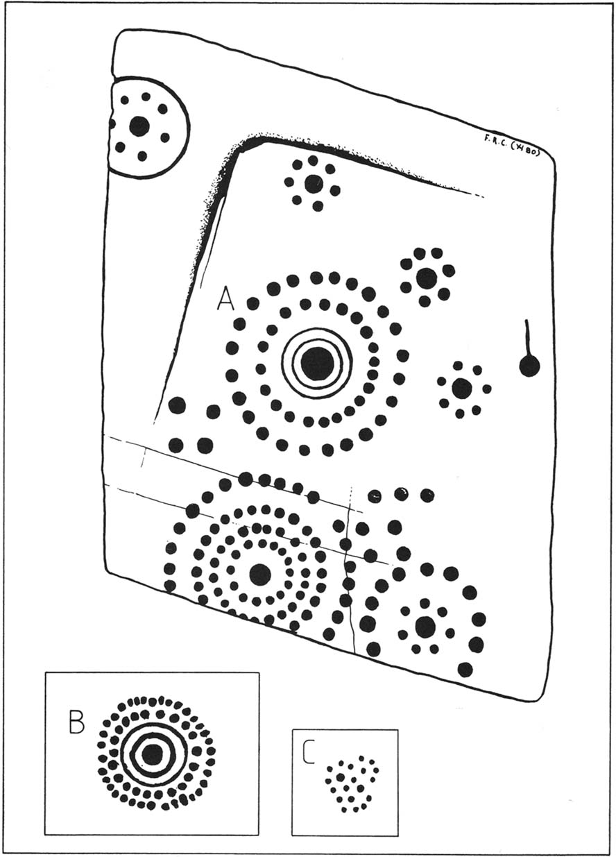
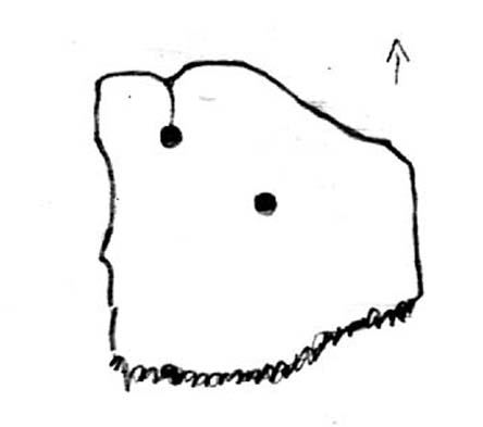
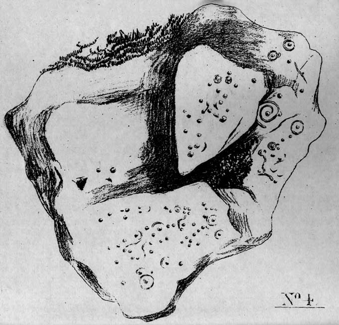
One of the lost High Banks carvings
This impressive carving was found somewhere in the vicinity of the well-known High Banks (01) cup-and-ring menagerie, with its clustered mass of cups and multiple rings. And the carving we see here possesses something of a similarity with its complex neighbour—but it remains lost.
The drawing was done by our old Scottish megalithomaniac Fred Coles, who discovered the carving when he visited the area around the beginning of the 20th century. It remained unpublished until fellow rock art student Maarten van Hoek (1990) explored the region and found it hiding away in the archives at the Stewartry Museum, Kirkcudbright. The multiple rings of cups surrounding central cups and cup-and-rings are very rare things indeed and this carving is utterly unique in the British Isles.
In Coles’ drawing, as well as the large carving, we have two other elements below, boxed. These are taken from a notebook found in the same Stewartry Museum and thought to have been done by a Mr G. Hamilton around 1866. In the lower-box, the double-ringed cup with its surround of two more rings of cup-marks was suggested at first by van Hoek (1990) to possibly be the same carving as that found by Coles. But he questioned this, sensibly, as the carved design ‘B’,
“comprises 35 cups (its diameter stated to be 21 inches / 51cm), whereas Coles’ diagram of ‘A’ shows only 24 outer cups. The unknown artist moreover says that, ‘The above (B) is one of a splendid group on Banks Farm.’ So this rosette (B) might be a completely different specimen altogether.”
I have to agree with him. In the second smaller box, ‘C’, the drawing of the cluster of cup-marks is taken from the same 19th century notebook in which the author said there was a cluster of
“70 to 100 small cups without any apparent system, except being in a group of 7 with cup in the centre—also 3 or 4 circles.”
No other details were given. Petroglyph explorers in the area should keep their senses peeled when meandering about here, for this and other missing carvings (High Banks 3).
References:
Morris, Ronald W.B., The Prehistoric Rock Art of Galloway and the Isle of Man, Blandford: Poole 1979.
van Hoek, M.A.M., “The Rosette in British and Irish Rock Art,” in Glasgow Archaeological Journal, volume 16, 1990.
Along the A836 road between Durness and Tongue, take the minor road north to Melness. Keeping to the right all the way along, drive almost to the very end, shortly before which is a double right-hand bend uphill. Park here and walk back along the road, north, past the cottage of Dun Bhuidhe for about 100 yards until you see the large sloping rock face with the telegraph post sticking out of it. That’s the place!
Archaeology & History
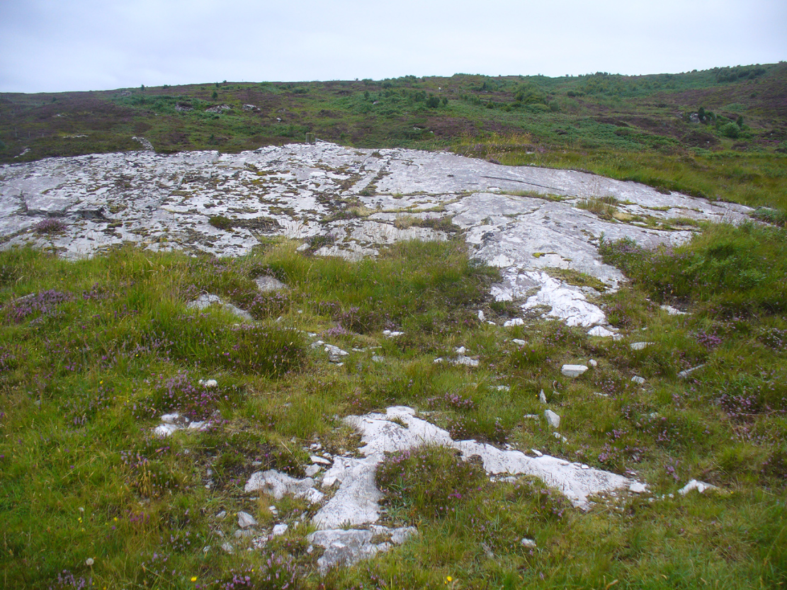
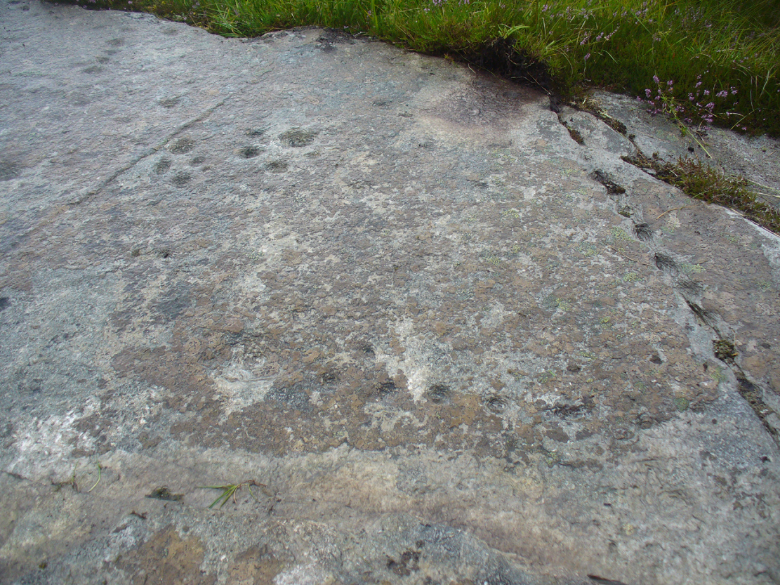
Not previously recorded, this cup-and-ring stone is right by the roadside up the far, lonely but beautiful glen west of Melness, which runs to a dead-end and into the heart of the silent moors high up in Sutherland’s remote landscape — and it’s a damn good one! It’s also the most northern example known of a Neolithic or Bronze Age petroglyph on the British mainland. The carving has been etched onto a large easterly sloping rock, fractured into several sections, with the decayed broch of Dun Bhuidhe rising to its immediate southwest. The setting alone is outstanding!
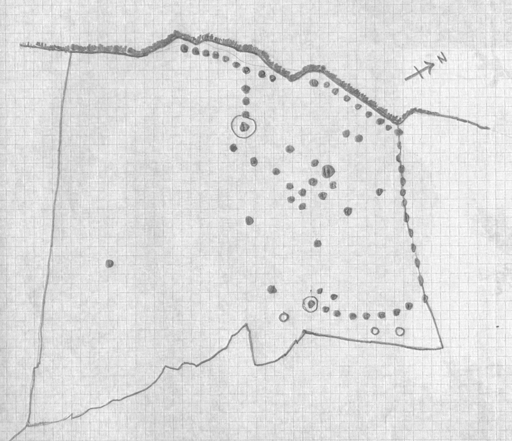
Sketch of the carving3 cups on the lower-east side
It was rediscovered on 25 August, 2015, after Prof Hornby and I had analysed the chambered tomb south of Dalvaid about half-a-mile away. In walking back to explore the aforementioned broch, I cut across the bottom of a nearby rock and found three distinct cup-markings etched near the bottom of its sloping face. Calling out to Prof Hornby, he retreated in his direction to the broch and came back to look at the top of this very large rock surface.
“There are some more cups on this section of the stone!” he called – and began to count them. “At least ten in this little section,” he said. There were indeed!
Carving, looking west
Carving, looking south
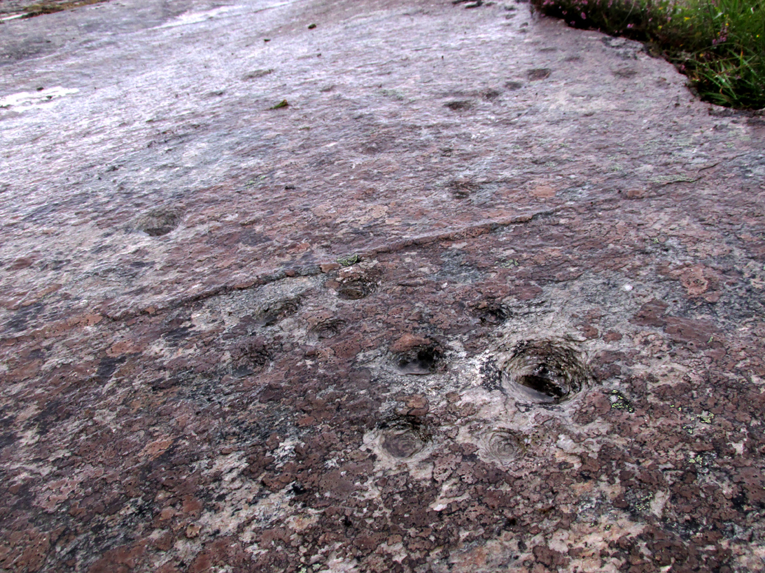
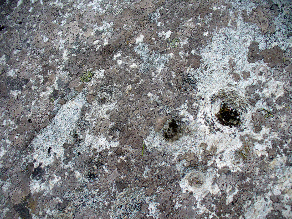
By the time we’d finished counting, drawing and assessing the design etched onto the rock surface, amongst at least two cup-and-ring elements we found at least 67 cup-markings, mainly carved onto the northwest portion of the stone. The first three that I’d seen were on the much lower eastern part and were etched in deliberate isolation from the primary design. However, of these three isolated cups, it looks as if one of them may have a spiral element curving out of it. This needs assessing in much better lighting conditions, because when we found it the skies were very grey and overcast, making an accurate survey very difficult (cup-marks on rocks can be hard to see unless daylight conditions are just right) – and, after a short while, the legendary Scottish midges appeared and began to feast on us, which stopped us in our work. The little buggers!
On a subsequent visit here with Sarah MacLean of Borgie in the summer of 2018, she found several more cup-marks beneath the lower arc shown in the above drawing (which I need to update, obviously).
Central features of the carving
Scatter of central cups
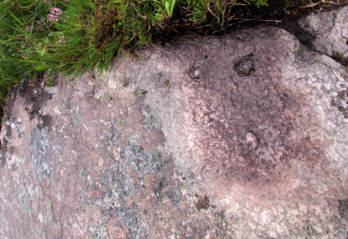
The most notable feature to this carving is the arrangement of the great majority of the cup markings. They were quite deliberately carved along the very top of the stone, close to its edge, in two contiguous lines of nine with a small gap separating them. At the northwestern end of this, a very notable feature occurs: a natural crack in the rock runs down the stone and, almost all the way down, we find a line of cups have been pecked onto the stone along the natural crack, with some of them near the top that are unfinished. These cup-marks are more elongated in form than the usual circular status; but this is due to them being etched into the cleft itself. From top to bottom there are 13 such cups. At the bottom of this line, another linear stretch of cups change direction and move back onto the main rock surface, just above another large long natural crack cutting across the rock. This gentle arc of cups (with two other possible cups beneath these) ends at a cup-and-ring, above which are two extra cups next to each other. Above these are a number of other cups of roughly similar size and depth, with a notably large one that gives the impression that the smaller cups around its edges are satellites to its larger parent body.
Line of cups on western edge
Row of cups etched into natural crack
Without any doubt there are other faint features that have been carved onto the stone, but due to the poor visibility factor at the time of its discovery we could not see anything other than the elements highlighted in the rough sketch. In looking through the many photos we took of this carving, there seem to be other faint lines, rings and cups within the overall design, but until we revisit the site (or someone else does!) such further features cannot be added to the drawing.
As the images of this petroglyph clearly shows, the primary feature defining it is the extensive line of continuous cup-markings running along the edges and enclosing a smaller number of internal cups. It’s an unusual element. Sequential line features such as these, defined by cups, are not common. My impression of this feature is that it was a pictorial representation of the horizons, inside which is played the story of….. something… But horizons they seem. Of course, this is a simplistic interpretation and is open to criticisms of any form. I care not! Much more importantly as far as I’m concerned is the fact that we’ve uncovered yet another unrecorded carving – and according to the official records, no such carvings exist here; but where one such carving exists, others are close by!
Watch this space…..
Acknowledgements: Considerable thanks must be given to Prof Paul Hornby, for use of his photos and without whose help this carving might never have been located. Cheers dood!
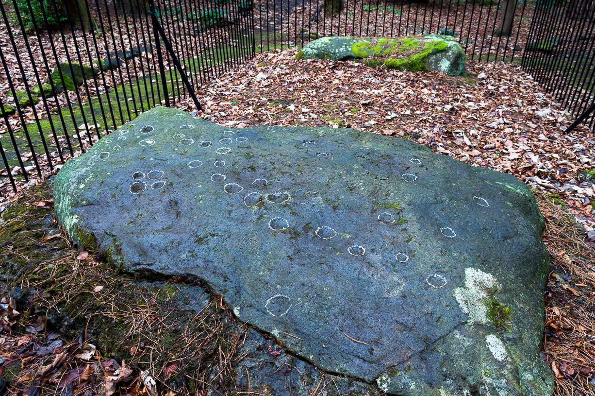
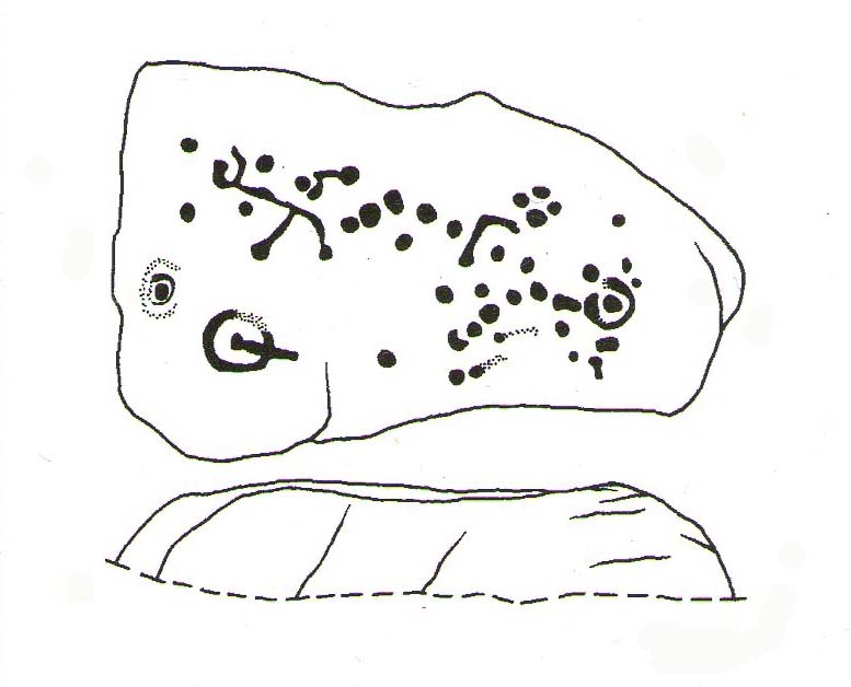
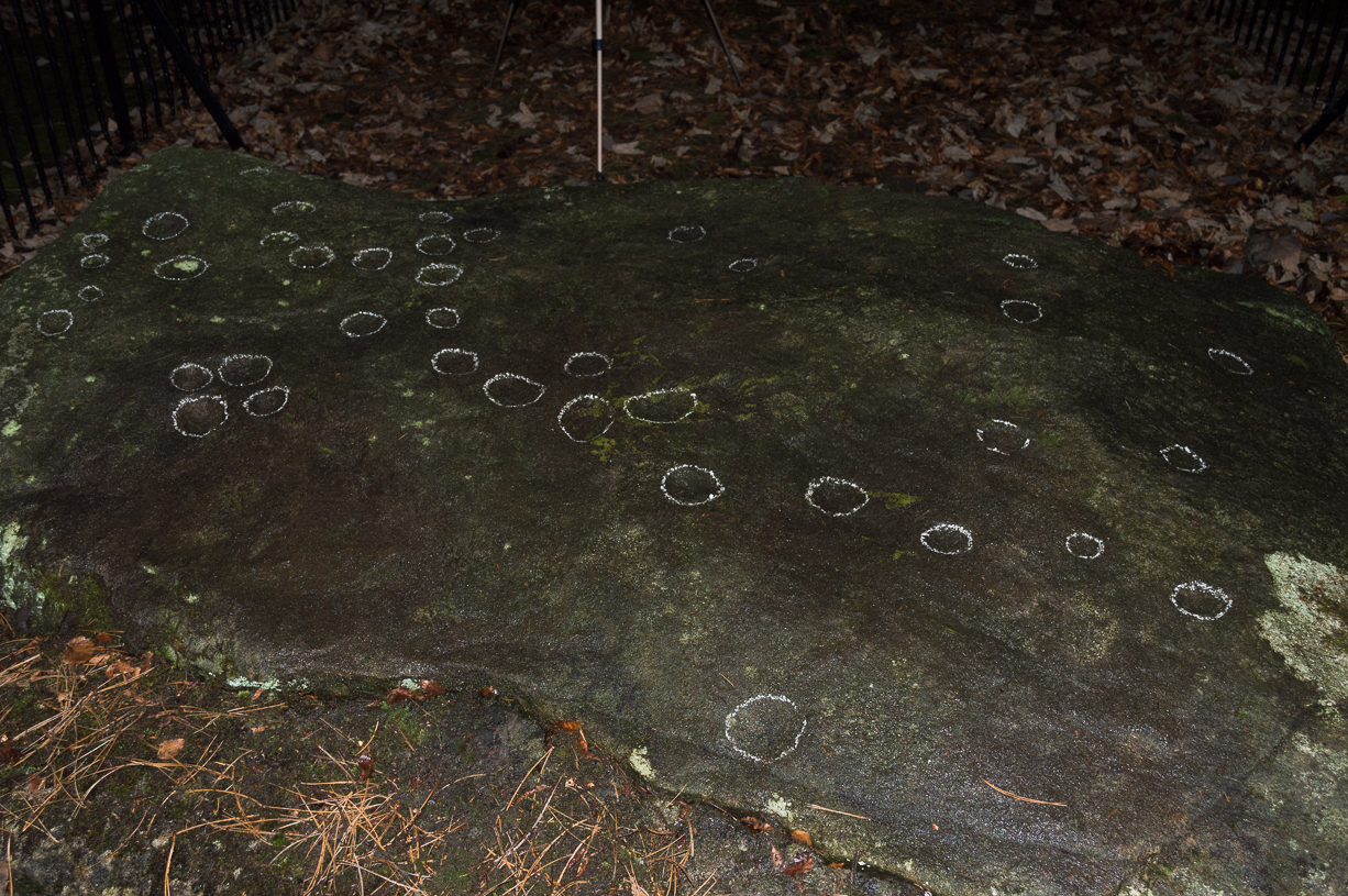
A recent visit to try find this intricate carving—the only one of its kind in Clackmannanshire—proved unsuccessful, and so I add it here in the hope that someone might know where it is and bring it back to light. It looked like quite an impressive petroglyph. If the stone isn’t hiding in undergrowth at the edge of someone’s garden, it may well have been destroyed—which would be appalling. As a unique design, this important carving should have been preserved. Even when the Victorian explorers found it, the covering stone circle had been greatly damaged and many stones in the ring had been removed. This carved stone remained intact however. When Mr R. Robertson (1895) and his friend visited the site, it was covered in sand and dirt and had fallen to the side of an internal cist:
“On clearing this away a remarkable feature was brought to light. The block was found to be elaborately ornamented on its sides and upper surface, with rings, spirals and lines. The labour of cutting these in the hard granite with primitive tools of the period must have been very great. Several successful photos of the stone and its carvings were taken by Provost Westwood, Dollar…. This stone has now been removed to the vicinity of Tillicoultry for safety.”
In the same article, George Black told slightly more of the design:
“The covering stone of the cist…bears on the face a series of concentric circles, and spirals springing from one of the groups of circles, Four grooves also unite the same set of circles with the left-hand edge of the stone. On the edge shown in the photograph there is another group, consisting of two concentric circles. The unevenness of the surface of the stone appears to have been of no moment to the sculptor of the circles, as the incisions follow the surface into its sinuosities and depressions.”
Not long after Robertson & Black’s visit, the great megalithomaniac Fred Coles (1899) came here—and he found that the “spirals” that Mr Black described were nothing of the sort.
“The huge irregularly-shaped diorite boulder which covered the cist has several cup-and-ring marks on one face and one side…. These marks are now, so I was informed when inspecting them, very much less distinct than they were when the photograph was taken (above) in 1894. It would be difficult now to describe the incised markings with accuracy; it is difficult even to see them when wet. But…I must take exception to the term ‘spirals’ as applied to any of these ‘rings.’ There are three groups of rings so placed as to make the outermost ring in each group touch that of the others (not an uncommon form), but there is no one true volute.
“…What is more noteworthy is the group of four long parallel, nearly perpendicular grooves issuing (probably) from the outermost ring of the group of five rings, and ending at the edge of the boulder.”
Alison Young’s 1937 sketch
Cole also noted that the carvings were to be found on the upper surface of the stone. It would seem very probable that the excessive erosion which Cole described was due to the fact that the stone was, many centuries earlier, exposed to the elements within the stone circle and not buried as it later came to be. It makes sense.
The excessive erosion was spoken of by the Royal Commission (1933) lads, aswell as the last person to describe the site, Ronald W.B. Morris (1981), who said that during his visits here between 1966-75,
“the author has only found traces of possible cups visible on the rough surface, which has flaked badly.”
Morris (1981) said that the stone measured “1½m by 1¾m by ½m (5½ft x 4½ft x 2ft)”—and was last known to be some 10 yards NW of the Tillicoultry House cottage, but we could locate no trace of the stone or its carving. If anyone is aware of the whereabouts or fate of this important neolithic carving, please let us know.
Morris, Ronald W.B., “The Cup-and-Ring and Similar Early Sculptures of Scotland; Part 2 – The Rest of Scotland except Kintyre,” in Transactions of the Ancient Monuments Society, volume 16, 1969.
Morris, Ronald W.B., The Prehistoric Rock Art of Southern Scotland, BAR: Oxford 1981.
We have no precise location for this carving, nor several of its petroglyphic relatives who lived within this arena for countless centuries until (you guessed it!) the advance of the Industrialists brought their profane ways to the region, with the usual disregard for local people and their unwritten traditions. Which is a great pity, for there were obviously some old stories and important archaeology hereby. Aubrey Burl (1988) for one, thought this cup-and-ring carving may have played its part in being one of the stones in a larger “four-poster” stone circle, although local history accounts tell that it was part of an impressive prehistoric tomb.
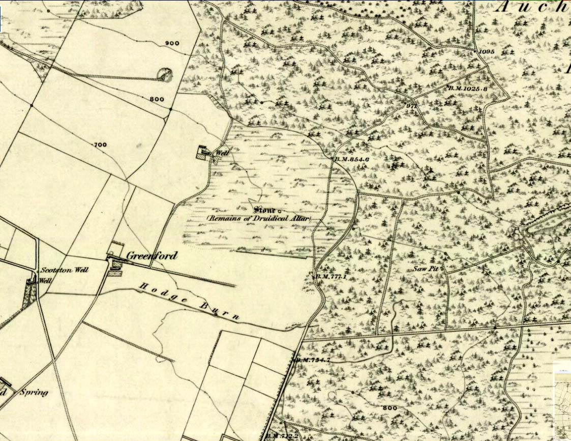
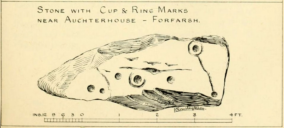
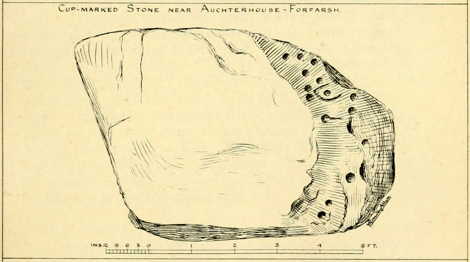
One of the Witches Stones
The Witches’ Stone we see illustrated here was one of at least two carvings in a cluster of stones. The great J. Romilly Allen (1881) wrote about the it, although it seems he never visited the site himself. Instead, his description came from that of a colleague, a Mr W. McNicoll, who told him that at the position marked on the early OS-map as a single “Stone” that was “Remains of a Druidical Altar” there were in fact
“two in number: one, an upright pointed stone, 5ft by 2ft by 3ft 6in high; ans the other lying 3ft 6in to the southwest, 7ft 6in by 5ft by 2ft 6in thick. The latter has fifteen cups, varying from 2 to 3in in diameter; one with a single ring carved on the sloping face at the south end of the stone. It lies horizontally and has two hollows, worn at the ends where the cups are, by the toes of persons climbing onto the top. The ground under this stone has been partly removed and it appears to rest on two others; but the whole appears to be natural and not a cromlech or rocking stone.”
Folklore
One of the Witches Stones
Reference was made to this “Witches Stone” in the 1860 Object Name Book of the region, where it was said to have been part of a larger group, “considered to have been used by the Druids as a place of worship.” This catch-all phrase of druidic relevance should be translated as “local traditional importance” where animistic rites of some sort would have occurred. Certainly we find the usual reverence or fear in the local tale told by Mr Hutcheson (1905) which he thankfully recorded following his visit to the site:
“Here…occupying a small knoll known locally as Greenfield Knowe, towards the western end of the plateau…two upright standing stones of boulder character formed a conspicuous feature. They were, if tradition be accepted, the survivors of a larger group. The same tradition records that the farmer of Greenfield Farm, requiring stones for the erection of dykes, removed some of the standing stones from Greenfield Knowe. He, however, speedily found unexpected difficulty in carrying out his intentions. The dykers whom he had employed absolutely refused to use the stones, alleging they would thereby bring misfortune upon themselves and families, , and threatened, rather than risk such calamities, to throw up the job.
“While in this quandry the farmer, it is said, had a vision: a ghostly figure appeared to him, and in a hollow voice warned him against interference with he stones on Greenfield Knowe, and concluded by the adjuration, “Gang ower the howe t’ anither knowe.” Needless to say, the farmer lost no time in obeying his ghostly visitor. Next morning he carted back the stones he had removed and sought material for his dykes elsewhere.”
This is probably the same tale, slightly reformed, which the local historian W.M. Inglis (1888) described, when he told that,
“About the beginning of the present century, when a worthy old parishioner was having some repairs carried out upon his house, he removed a few of the large stones with the intention of having them built into the walls. Throughout the night, however, an eerie feeling came over him, his conscience was on fire, he could get no rest. Accordingly he got out of bed, yoked his horse into the cart, and like a sensible man replaced yjr sacred stones where he found them, went home, and thereafter slept the sleep of the righteous.”
From Ilkley train station, head up Cow Pasture Road and get to the Cow & Calf Hotel (if needs be, ask a local). From its car-park, cross the road and go along the straight-ish footpath onto the moor. Less than 200 yards on, you’ll hit a main track (and a faint cup-marked stone). OK – walk down this track (left) for 30-40 yards, then walk left again into the heather for about 10 yards. You’re looking for a small rounded stone and you’re damn close!
Archaeology & History
…and from another angle
Just over 40 yards east of the very basic Brown Law cup-marked stone, we find this slightly more exotic petroglyph, keeping low in the undergrowth. Difficult to see unless the daylight is just right, preferably as the sun is rising or setting (as with many neolithic carvings), on this small slightly rounded stone we see a central cup-mark surrounded by a double-ring (unfinished, perhaps on its northern edge)—although an outer cup seems to touch the edge of this second ring. As the faint images here show, there are other cups and shallow lines also etched onto the stone, but these are gradually fading as the years go by. It was originally found close to a small cairn that has seemingly been destroyed in recent years.
The carving can be troublesome to find when the heather and bracken gets growing, so it’s best explored in the Winter and early Spring—unless of course you want me to show you it, along with the hundreds of others on these moors! If so, gimme a shout. 😉
References:
Boughey, Keith & Vickerman, E.A., Prehistoric Rock Art of the West Riding, WYAS: Wakefield 2003.
Cowling, E.T., Rombald’s Way: A Prehistory of Mid-Wharfedale, William Walker: Otley 1946.
Hedges, John (ed.), The Carved Rocks on Rombalds Moor, WYMCC: Wakefield 1986.
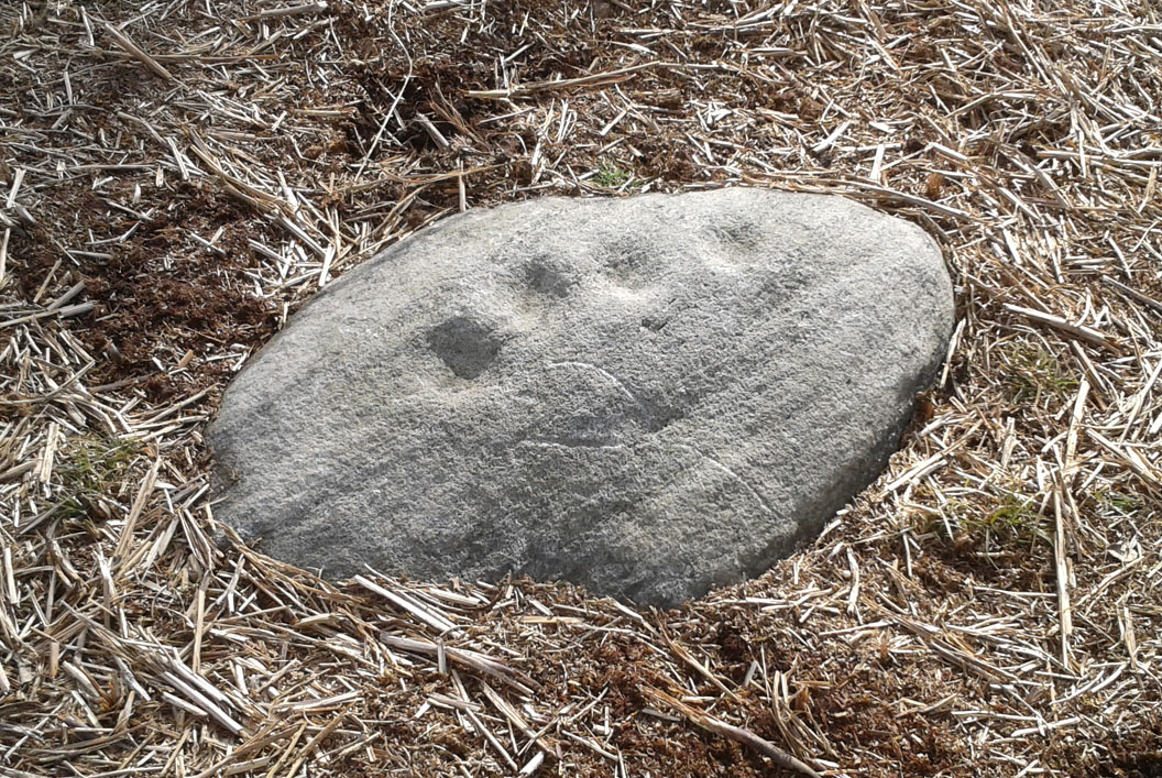
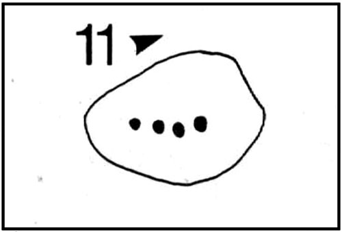
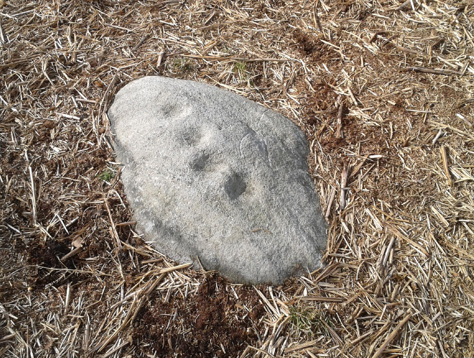
A carving that I first visited when I was a child – but one which, curiously, caught my attention. The small arc of four cup-marks that you can see on the stone was an integral feature of other carvings in this particular region—though not all, of course. It seemed to me at the time that it had symbolic significance, as the arc occurred in a number of other Baildon petroglyphs. Astronomy was my fetish at that time and so I saw the arc as solar or stellar movements across the sky, represented by the cup-markings. It was one of many fascinating Rorschach’s that I encountered, just as rock art students across the world do when looking at these ancient carvings. However, the simple symbolism of this and similar nearby carvings has stuck and plays under my skin somewhat: one of those curious non-egoic tickles, constantly nudging away, as if there’s something in it, but being looked at from the wrong angle…
John Hedges 1986 sketch
Looking down at the cups
Anyway… All we have here is a primary design of four cup-marks reaching across a small earthfast stone. Other simple carvings are found close by and there are the remains of several prehistoric cairns circles within a few hundred yards. Beneath the deep bracken-mass, it is highly probable that other ancient remains remain hidden.
The carving was first recognised in one of Sidney Jackson’s (1958) archaeology bimbles in the 1950s with his bunch of northern antiquarians from Cartwright Hall, Bradford. It later found its way into the survey of John Hedges (1986) where he described it, simply:
“Small, lozenge-shaped, smooth grit rock, sloping NW-SE into grass and bracken, four symmetrical cups in slight curve.”
References:
Baildon, W. Paley, Baildon and the Baildons – parts 1-15, Adelphi: London 1913-1926.
Bennett, Paul, Of Cups and Rings and Things, unpublished: Shipley 1981.
Bennett, Paul, Megalithic Ramblings between Ilkley and Baildon, unpublished: Shipley 1982.
Boughey, Keith & Vickerman, E.A., Prehistoric Rock Art of the West Riding, WYAS: Leeds 2003.
Cowling, Eric T., Rombald’s Way, William Walker: Otley 1946.
Hedges, John, The Carved Rocks on Rombald’s Moor, WYMCC: Wakefield 1986.
Jackson, Sidney, “Cup-Marked Boulders, Baildon Moor,” in Cartwright Hall Archaeology Group Bulletin, 3:2, 1958.
Take the same directions as if you’re going to visit the Naked Jogger Carving (stone 612), not far from the well-known Tree of Life Stone. From the Naked Jogger carving, walk up the small outcrop of rocks that bends above you. Barely 100 yards up when you reach the top, you’ll notice a single large sloping stone barely 50 yards ahead of you in the same field. That’s the spot!
Archaeology & History
This is a little-known beauty of a carving just off the edge of the quiet moors that are littered with prehistoric remains. It was only rediscovered a few years ago — by myself if you believe the writings of rock art student Keith Boughey (2010) in his essay on the validity of so-called “amateurs”who research and discover petroglyphs (Boughey’s essay is scattered with mistakes). But I’d never even visited this carving until two years ago! The stone was in fact found during a field-walk by early members of the Northern Earth Mysteries group in August 1989 (Wilson 1990) and subsequently described and illustrated for the first time by Phil Reeder (1990).
Close-up of main cluster
As can be seen in the photos accompanying this site profile, the rock on which the carving has been done has, at some point in the past, been cut into and its edges have been hacked away and destroyed, literally cutting into the overall design. We have no idea what the original size of the stone was, obviously, but this petroglyph was once larger than the design that we see at present. Such is the price of ‘progress’, as some folk call it.
Anyway – a few months after the carving was rediscovered, Phil Reeder (1990) wrote:
“After a visit to the Tree of Life stone…a cursory inspection by the NEM Group was made on nearby rock outcrops, part of which showed evidence of recent exposure due to soil erosion.
“One stone in particular stood out as five shallow cups and associated rings could be discerned. When cleaned, it became apparent that further carvings extended beneath a thin eroding soil layer. When this layer was cleared, a complex set of carvings were revealed.
“Only preliminary work at the site has been carried out to date, but it appears that the carvings comprise of at least 28 cups, 13 of which have associated rings; several of the cups are linked by gutters forming an intricate design, one gutter part enclosing 11 cups. The carvings on the lower edge of the stone have weathered badly and are difficult to interpret.”
Reeder’s so-called “amateur” description is a good one. Certainly more accurate than the subsequent one by Boughey (“I’m a professional”) & Vickerman (2003):
“Large rock of coarse grit whose surface slopes with the hill. About forty cups, some large, many with single rings, and many curving grooves, the whole forming a remarkable, complex design.”
Phil Reeder’s 1990 drawing
Boughey & Vickerman’s sketch
We can see in the respective drawings by both Reeder (left) and Boughey & Vickerman (right) that some elements which should have been included in the ‘official’ drawing were missed, yet had been accurately included in the earlier ‘preliminary’ drawing, as Mr Reeder put it. I hope that readers will forgive me pointing out these seemingly minor elements; but I do it to illustrate the ineffectiveness of more recent rock art students who are gaining the title of ‘experts’ in this field. It’s important to recognise that, in this field of study, “experts” are few and far between indeed… I’ve certainly yet to meet any!
Northern end of carving
Southern side of carving
The carving is mentioned briefly in Beckensall’s (1999) introductory study, with little comment. But of note here is not only the curious linear feature running between two cup-and-rings, but the position of the stone in the landscape. For if you sit either upon or next to this carving, you are looking east straight across the gorgeous Fewston valley directly at the prominent wooded hill of Sword Point. As it slopes down into the present-day greenery of fields and scattered woods, the Wharfe Valley spreads out to the distant east and, as the sun rises and scatters its rays onto the wet morning stone here, the design on the rock awakens with much greater visual lucidity than that which our daytime eyes bestow to us. In all likelihood, sunrise was an important element in whatever mythic function underscored this curious carving, with its human-like figure rising on its southern side, emerging from the edge of the rock, personifying perhaps the rising solar disc and the living landscape as the daylight breath awoke Earth’s creatures; or maybe it signifies a symbolic group of people gathered together watching the sunrise…
Of course, I’m dreaming… (how very amateur of me! 🙂 )
References:
Barnett, T. & Sharpe, K. (eds.), Carving a Future for British Rock Art, Oxbow: Oxford 2010.
Beckensall, Stan, British Prehistoric Rock Art, Tempus: Stroud 1999.
Boughey, Keith, “The Role of the Amateur in the Study of UK Prehistoric Cup-and-Ring Art,” in Barnett & Sharpe, Oxford 2010.
Boughey, Keith & Vickerman, E.A., Prehistoric Rock Art of the West Riding, WYAS: Leeds 2003.
Chappell, Graeme, “North Yorkshire Rock Art – New Discoveries,” in Northern Earth, no.62, 1995.
Michell, John, The Earth Spirit, Thames & Hudson: London 1975.
Reeder, Phil, “Snowden Carr Rock Carvings,” in Northern Earth Mysteries, no.40, 1990.
Along the B6265 Pateley Bridge-Grassington road, roughly halfway between Stump Cross Caverns and the turn to Skyeholme and Applecross (New Lane) is a dirt-track on your right-hand side called Black Hill Road. Walk down here for a few hundred yards till y’ reach the gate on the right. A track goes downhill to the psilocybin-rich pastures of Nussey Green. Several hundred yards down, to the right-hand side of the track, we find this and its several companions. Look around!
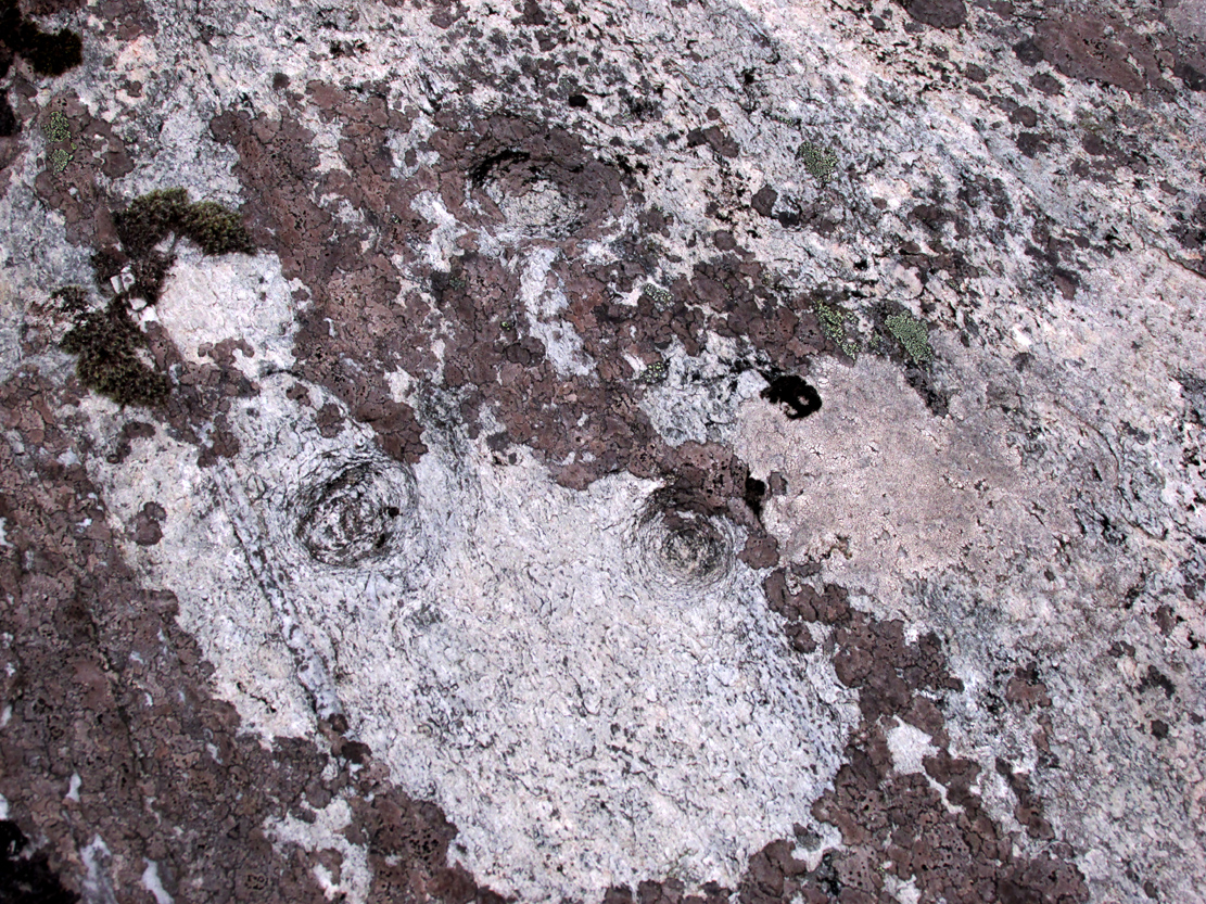
Archaeology & History
Sketch showing cups
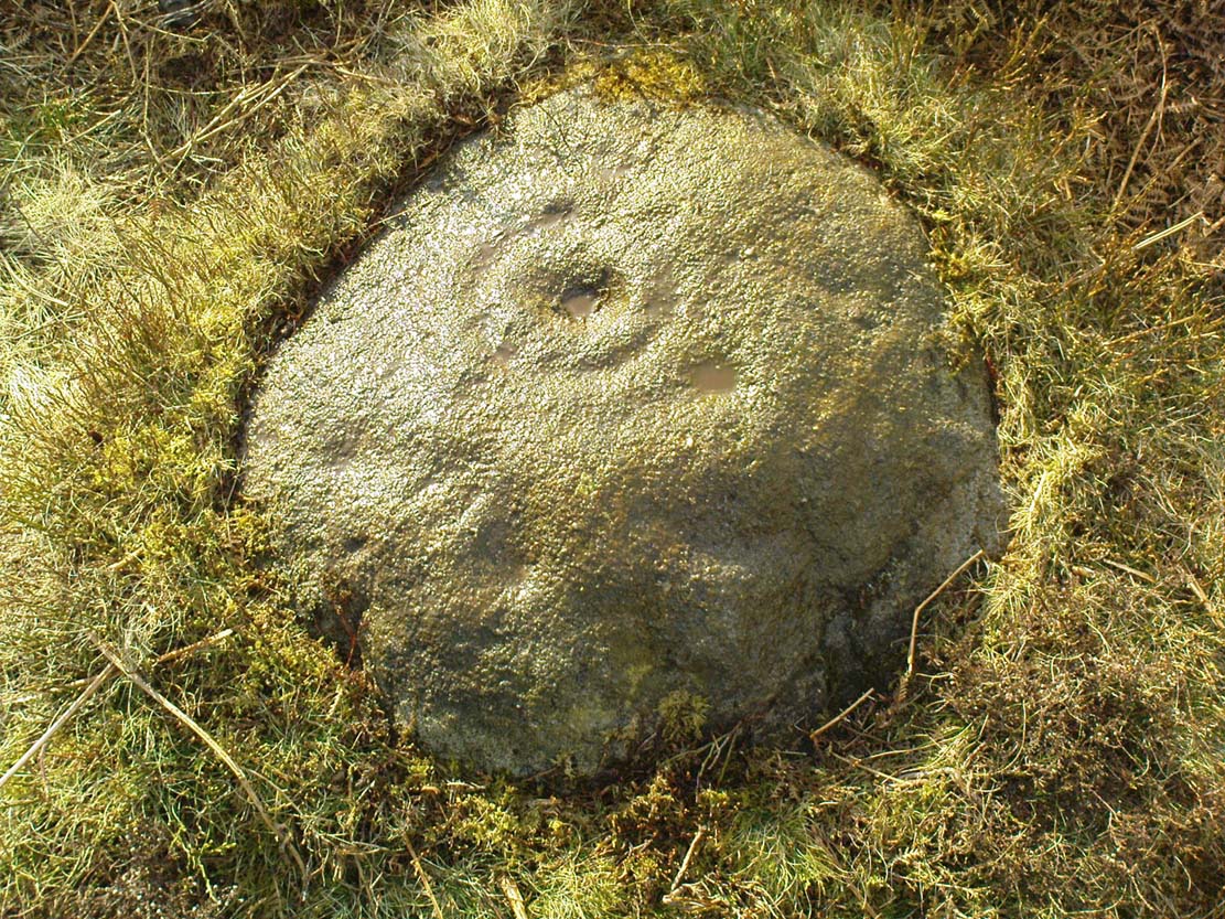
Just a few yards away from the Skyrehome Carving-404, this very basic petroglyph was rediscovered by Stuart Feather (1969) during one his many forays in this area. Although the stone has what initially seems to be a number cup-marks on it, it seems only two of them are man-made. The rock art students Boughey & Vickerman (2003) think there may be up to four of them.
References:
Boughey, Keith & Vickerman, E.A., Prehistoric Rock Art of the West Riding, WYAS 2003.
Feather, Stuart, “Appletreewick, W.R.: Black Hill,” in Yorkshire Archaeological Journal, volume 42, part 167, 1969.
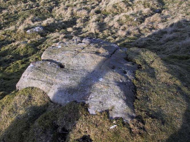
Going down (south) off the B6265 Black Hill Road towards Skyreholme, turn right and go all round the hill ahead of you, but instead of looking to the right (where other carvings, described elsewhere, are found), turn left where the collapsed entrance to a mine-shaft is visible about 50 yards up the hill on the left. Walk up here, keeping to the right side of the collapsed mine, till you reach this rock.
Archaeology & History
Only for the purist petroglyph fanatics amongst you, the rock art students Boughey & Vickerman (2003) allege there to be four cup-markings here—and debatable ones at that—but we could really only make out the topmost cup, shown in the picture and an elongated one (which they think may have been two cups merged into one). A faint “X” is also carved on the stone, possibly from the mining days.
References:
Boughey, Keith & Vickerman, E.A., Prehistoric Rock Art of the West Riding, WYAS: Wakefield 2003.
Panorama Stone 228, with cups highlighted (after James Elkington)
Come out of Ilkley/bus train station and turn right for less than 50 yards, turning left up towards White Wells. Go up here for less than 100 yards, taking your first right and walk 300 yards up Queens Road until you reach the St. Margaret’s church on the left-hand side. On the other side of the road, as well as a bench to sit on, surrounded by trees is a small enclosed bit with spiky railings with Panorama Stones 227, 228 and 229 all therein: the one in the centre being the one we’re dealing with here.
Archaeology & History
Originally located ¾-miles (1.2km) WSW of its present position in Panorama Woods (at roughly SE 10272 46995), along with its petroglyphic compatriots in this cage, the carving was moved here in 1890 when a Dr. Little—medical officer at Ben Rhydding Hydro—bought the stones for £10 from the owner of the land at Panorama Rocks, as the area in which the stones lived was due to be vandalized and destroyed. Thankfully the said Dr Little was thoughtful and as a result of his payment he had some of the stones saved and moved into their present position. However, this carving is but a fragment of its former self.
John Hedges 1986 sketchClose-up of cups (James Elkington)
It was originally to be seen within a large prehistoric enclosure—which was completely destroyed when rich houses were built hereby, without any evaluation of the site ever being made. But particularly impressive is the fact that this now enclosed sedated stone carving was originally the large rocky base for a small rocking stone, which also had cup-markings on it and a faint cup-and-ring. This is very unusual indeed – and perhaps unique in Britain? Thankfully, several Victorian antiquarians visited and made notes and a sketch of the site before it was uprooted and a large section of it destroyed. In J. Romilly Allen’s article (1879) he told that, just a couple of yards from the more famous and ornate Panorama Stone (229), a
“second stone is of irregular shape, measuring 15ft by 12ft, and supporting a smaller stone of triangular shape 6ft long by 4ft broad. Both upper and under stone are covered with cups and rings, but the sculptures have suffered much from exposure. The superimposed rock has eleven cups, two of which are surrounded by rings. The under stone has 42 cups, nine of which have rings. Amongst these are two unusually fine examples, one has an oval cup 5in by 4in, surrounded by two rings, the diameter of the outer ring being 1ft 3in. Another has a circular cup 3in diameter, and five concentric rings, the outer ring being 1ft 5in across.”
J.T Dales 1878 sketch, with CR227 on top of itOriginal location of stone
In a sketch of the site by J. Thornton Dale done about the same time as Allen’s visit, and reproduced here (apologies for the poor quality), the “five concentric rings” that Mr Allen mentioned are not shown, but clearly a spiral design had been seen by Mr Dale’s eyes. Fascinating…. The large mass of carvings immediately left of the spiral is in fact the smaller upper stone known by modern archaeologists as carving 227.
Today, all we can see of this petroglyph are two cup-and-rings, and one faint double-cup-and-ring; several incomplete rings or arcs, and at least another 30 single cup-marks, some of which have short limes running to or from them. The rest of original stone base with its other multiple rings or spiral design were obviously destroyed.
As with many of the Ilkley carvings, Boughey & Vickerman’s (2003) description barely does the stone justice. They described it simply:
“Large rock, now set in concrete base, the surface rapidly deteriorating. Over forty cups, three with single rings, one showing traces of a second, grooves.”
The mightily impressive Panorama 229 carving sits next to this one and is truly worth checking out!
References:
Allen, J. Romilly, “The Prehistoric Rock Sculptures of Ilkley,” in Journal of British Archaeological Association, volume 35, 1879.
Bennett, Paul, The Panorama Stones, Ilkley, TNA: Yorkshire 2012.
Bennett, Paul, Aboriginal Rock Carvings of Ilkley and District, forthcoming.
Boughey, Keith & Vickerman, E.A., Prehistoric Rock Art of the West Riding, WYAS: Leeds 2003.
Cowling, Eric T., Rombald’s Way, William Walker: Otley 1946.
Downer, A.C., “Yorkshire Archaeological and Topographical Association,” in Leeds Mercury, August 28, 1884.
Hadingham, Evan, Ancient Carvings in Britain, Souvenir Press: London 1974.
Hedges, John, The Carved Rocks on Rombald’s Moor, WYMCC: Wakefield 1986.
Heywood, Nathan, “The Cup and Ring Stones of the Panorama Rocks”, in Transactions Lancashire & Cheshire Antiquarian Society, Manchester 1889.
Speight, Harry, Upper Wharfedale, Elliott Stock: London 1900.
Acknowledgements: With huge thanks to both Dr Stefan Maeder for help in cleaning up the stones; and to James Elkington for taking the photos and allowing ’em for use them in this site profile.