Lilla Cross is situated on Fylingdales Moor, north Yorkshire, between Pickering and Whitby at the junction of two major moorland footpaths. It is located close to the Fylingdales Ballistic Missile Early Warning Station – which resemble giant golf balls on the horizon.
Archaeology & History
Woodwark’s 1930s photo of Lilla Cross
The ancient cross is 10 foot high and free-standing but it sits upon what is probably a ruined Bronze-Age bowl barrow called Lilla Howe; the recumbent stones that lie around the base of the cross may form part of that. It is a sturdy, stocky cross that has some letters carved onto it, one in particular being a large letter “C” possibly meaning Christos (Christ) and with that a small thin cross; there are a few other faint letters but these are difficult to decipher now. A plaque on a nearby stone gives information about the cross. I think Lilla Cross was used as a sort of Medieval milestone or way-marker – hence the lettering on the cross.
In 1952 the cross was moved to Sil Howe near Goathland but 10 years later in 1962 it was returned to its original site on top of Lilla Howe. In the 1920s excavations on the barrow revealed some artefacts of jewellery, but no remains of Edwin’s trusty chief minister were found; the jewellery was, in fact, said to date from the mid 9th century. Lilla Cross has been referred to by historians as the oldest christian cross on the north York Moors.
Folklore
Lilla Cross on 1854 Map
According to the legend, in AD 625 or 626 King Edwin of Northumbria was travelling with his entourage across the moors, but an assassin had been dispatched by the king of the west Saxons to kill Edwin. The assassin lunged forward with his poison tipped sword, but Lilla his chief minister at the king’s court, leapt in between his sovereign and the swordsman. Poor Lilla took the full thrust of the sword and died on the spot thus saving the king from being murdered. King Edwin, who was greatly impressed by this selfless act of devotion, ordered that Lilla being a newly converted christian be buried here in a christian way though he asked that a number of articles be placed with the body including gold and silver. The king then had a cross erected in memory at the spot where Lilla died. But it seems likely that the cross dates from the 10th century, though there may have been an earlier Saxon cross here. References:
Ogilvie, Elizabeth & Sleightholme, Audrey, An Illustrated Guide to the Crosses on the North Yorkshire Moors, Village Green Press: Thorganby 1994.
White, Stanhope, Standing Stones and Earthworks on the North Yorkshire Moors, Fretwell & Cox: Keighley 1987.
Woodwark, T.H., The Crosses on the North York Moors, Whitby Literary & Philosophical Society 1934.
Standing Stone (destroyed): OS Grid Reference – TA 040 587
Archaeology & History
Information on this stone is sparse and the grid-reference cited is a close approximation of its precise location. And were it not for the records of Victorian folklorists, its existence may have been completely lost. The first reference I’ve found of it is in Nicholson’s East Yorkshire (1890) survey, but I am hoping that someone, somewhere, made archaeological notes of the site (am I hoping for too much here…?) The stone appears to have stood upon, or was very close to, the local boundary line between Nafferton and Driffield—which means there could be a record of it in any perambulation accounts of the region.
Folklore
John Nicholson (1890) told us the following intriguing bitta folklore about this stone, saying:
“About half way down the hill forming the eastern slope of Nafferton Slack, by the roadside, to prevent waggons leaving the roadway, stood a large stone, which was believed to have wonderful powers. At night, at certain seasons, it glowed like fire, sometimes it seemed but the portal of a well-lighted hall; and one old stone-breaker declared he had heard wonderful music issuing therefrom, the like of which he had never heard before; while on one occasion he had seen troops of gaily-dressed elfins repairing thither, some on foot and some on carriages, and they all went into this mysterious hall. The old man is dead, the stone is gone, and the fairies have departed.”
Some twenty years later, Mrs Gutch repeated the story, but added no further details. One wonders whether the information about a fairy hall implied the former existence of a mound or tumulus next to the old stone (a few hundred yards south, just off the same boundary line, we find the remains of the curiously named tumulus of Cheesecake Hill). Any further info would be most welcome…
References:
Gutch, Mrs E., Examples of Printed Folk-lore Concerning the East Riding of Yorkshire, David Nutt: London 1912.
Nicholson, Folk-lore of East Yorkshire, Simpkin Marshall: London 1890.
Get up to the Aiggin Stone and turn your back to Robin Hood’s Bed and Blackstone Edge, facing (roughly) north. There’s a small path just to the left of the Aiggin Stone, running northwest (don’t take the more pronounced footpath on its right, or you’ll get a bit lost). Walk down this path for about 60-70 yards and you can’t miss it!
Archaeology & History
Initially I thought this was the stone described in James Maxim’s (1965) exploratory study of the ancient route of the Long Causeway, not far from the Aiggin Stone, running up between Littleborough and Sowerby Bridge, across the Yorkshire border — but I quickly realised my error! Maxim’s upright was one of the boundary markers and is a good 100 yards away from this little fella, seemingly divorced from history. But he’s a curiosity that could do with an explanation…
Standing Stone; and Robin Hood’s Bed on horizon
The stone is less than a metre tall but appears to have had been a little taller in earlier days, having the top of it knocked off — either accidentally or otherwise (someone suggested that the small stone on the ground by its side was once the top of the stone). It stands just a yard to the side of an old causeway running from the disused quarries a few hundred yards away, up to the Aiggin Stone. It may have been an old wayside marker stone. It’s certainly old and nobody seems to have said owt about it, so I thought that I’d highlight it here. Any further info on the little fella’s history would be most welcome!
In the heathlands above here we found remains of old walling in the edge of the ancient peat, some of it cutting through into view and some of it still beneath the surface. There wasn’t much of it (though we weren’t here for long), but it looked familiar and old… How old is hard to say at the moment. Who built them? How much more can be found nearby? Were they part of the quarrying operations, or destroyed by them? Anyone know owt more?
References:
Maxim, James L., A Lancashire Lion, J.L. Maxim Trustees: Leeds 1965.
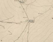
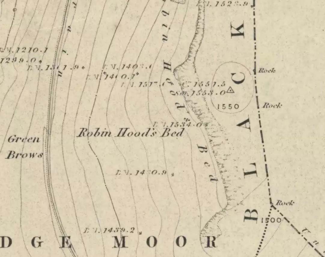
Follow the same directions to get to the Aiggin Stone. Once here, go over the stile by the fence opposite towards the great geological ridge less than half-a-mile south. Head for the triangulation pillar right on the top of the ridge, and there, about 20 yards past it, higher-up than the triangulation pillar at the very top of Blackstone Edge, is Robin Hood’s legendary stone bed!
Archaeology & History
Robin Hoods Bed, looking north
There’s very little of archaeological interest known up here, save a mass of flints and scrapers that have been found scattering the moorland heights hereby, from the mesolithic period onwards. But we have a relative lack of neolithic to Iron Age remains — officially anyhow! A possible standing stone can be found a few hundred yards south, but there’s little else.
The rock that’s given its name to Robin Hood’s Bed overlooks the very edge of the ridge, detached from the main section, with a large and very curious nature-worn ‘bed’ on its very crown, more than 4 feet wide and about 7 feet long, into which one comfortably lays. It was named in the boundary records of the township of Rishworth in 1836, where it describes other historical stones, saying:
“thence under Robin Hood’s Bed to a stone marked ‘W.S.G.S. 1742, 1770, 1792, and the following figures and letters, ‘1826 I.L.S.'”
Folklore
This enormous millstone grit boulder, sitting 1550 feet upon the high moors is, according to legend, a place where our famous legendary outlaw once slept. Whilst sleeping here, some of his followers were said to have kept guard and looked over him.
Robin Hood’s Bed, from below
A rather odd piece of folklore recited by Jessica Lofthouse (1976) is that “no winds ever blow” at Robin Hood’s Bed, who then went on to tell of the time she visited the place. Walking along the rocky ridge where the stone bed is found, the winds were such that “we had almost been blown over the edge,” until just a few hundred yards further when they eventually reached the fabled site, Nature granted them a sudden calmness unknown to all the high moorlands around, affirming the curious folklore.
The ceremonial stone ‘bed’
Robin Hood’s Bed itself was undeniably an important ceremonial site for both rites of passage and ritual magick to our indigenous ancestors. The place screams of it! It also seems very likely that the hero figure of Robin Hood replaced an earlier mythological character, akin to the fabled female creation deity, the cailleach, found commonly in more northern and Irish climes, whose echoes can still be found around our Pennine hills. For we find that Robin Hood was said to have taken a large boulder from here and with a mighty heave threw it six miles across the landscape due west into the setting sun, where it eventually landed at Monstone Edge, near Rochdale! Local people were so astounded at this feat that the stone was given the name of Robin Hood’s Quoit.
7ft tall natural standing stone
The old place-name authority Eilert Ekwall (1922) related the folklore that the giant ridge of Blackstone Edge “is said to refer to a boundary stone between Yorkshire and Lancashire.” Which may be the curious upright standing stone, more than 7 feet tall, less than 50 yards NNE which gives a very distinct impression of having been deliberately stood upright, amidst this mass of loose geological droppings! It would be helpful if there was a geologist in the house who could tell us decisively one way or the other…
Another etymological possibility that has been posited relates to the word ‘bed’ at this site. Ordinarily it would be sensible to attach the word to the great stone ‘bed’ atop of the poised boulder. But with the attached legends symptomatic of prehistoric monuments, it would not be improper to highlight that the old Welsh word ‘bedd‘ (a place-name element that is not uncommon in Lancashire) means, “a grave or tomb”. And this site would be ideal for such an old prehistoric cairn…
References:
Bennett, Paul, The Old Stones of Elmet, Capall Bann: Milverton 2001.
Ekwall, E., The Place-Names of Lancashire, Manchester University Press 1922.
Lofthouse, Jessica, North Country Folklore, Hale: London 1976.
Smith, A.H., The Place-Names of the West Riding of Yorkshire – volume 3, Cambridge University Press 1961.
From Littleborough, take the Ripponden and Halifax A58 road up-uphill till you get to the White House pub near the very top. From here, cross the road and walk along the track below the disused quarry for a coupla hundred yards till you meet with the straight uphill track. Go up here and, near the very top, you’ll see the upright stone right beside the footpath on your left.
Archaeology & History
Aiggin Stone and cairn
This ancient boundary stone has long been an etymological oddity. It aint a prehistoric stone by any means (soz…), though its nature has never truly been decided for sure. Some have posited it as Roman in origin, others that it’s merely a waymarker (in case y’ get lost in the fog up here), others that it’s a milestone, and the more common notion is that it’s a boundary marker of the counties of Yorkshire and Lancashire (it’s position in the landscape presently sits it in Lancashire). As far as I’m concerned, the stone’s late-medieval in nature…
Standing by the old Roman road a short distance from the very top of these high Pennine hills on the Yorkshire-Lancashire border, a faint old Latin cross, plus the letters “I.T.” are etched onto its sides. In the 1930s the stone was found laid in the moorland heather, but was thankfully resurrected in 1933. Since then however, it’s been knocked over a couple more times, but presently stands proudly upright — until the day comes when some other halfwits decide to knock it down again! In its earlier days, James Maxim (1965) described the stone thus:
“It is an irregular block of gritstone 7 feet long, tapering from 2 feet 6 inches to 2 feet wide and it is about 10 inches thick. On one bedding face and a few inches from the top is an incised cross with the ends of the arms slightly expanded. This is 1 foot 4 inches long and 10 inches wide, the horizontal bar crossing the vertical at about 5 inches from its upper end.”
Looking northeast
First highlighted on an engineer’s map from 1800, Herbert Collins (1950) assumes Aiggin to be “a corruption of Agger”, being a Latin word meaning, “a pile, heap, mound, dike, mole, pier – in Roman antiquity, an earthwork or other artificial mound or rampart.” Due to the monolith’s proximity to the supposed Roman road there is great likelihood in it being as such, plus “agger” can also mean a Roman road or military way. Collins cites other possibilities: aggerere, “to bear to a place, to heap up,” or “that which is gathered to form an elevation above a surface” – which is certainly applicable here! James Maxim (1965) thought,
“The name ‘Aiggin’ suggests a pronunciation resembling either ‘edge’ or ‘hedge’ and thus it might mean ‘Edge Stone’. Alternatively it could be derived from the French ‘aguille’, meaning a needle or sharp-pointing rock.”
The view from here is truly excellent — though if you walk to the rocky crags of Blackstone Edge a half-mile to the south (y’ can’t miss ’em from here) and sit by Robin Hood’s Bed, it gets even better! A smaller, possible standing stone can be seen just 200 yards northwest of our Aiggin Stone; with the top of the stone seemingly knocked off in bygone years. Not far from here are the remains of some old hut circles, emerging from beneath the old landscape.
References:
Collins, Herbert C., The Roof of Lancashire, J.M. Dent: London 1950.
Maxim, James L., A Lancashire Lion, J.L. Maxim Trustees: Leeds 1965.
From the village of Midgley, high above the A646 Halifax-to-Todmorden road, travel west along the moorland road until you reach the sharp-ish bend in the road, with steep wooded waterfall to your left and the track up to the disused quarry of Foster Clough. Go up the Foster Clough track for 100 yards and, when you reach the gate in front of you, go over it but follow the line of the straight walling uphill by the stream-side (instead of following the path up the quarries) all the way to the top. Here you’ll see the boundary stone of Churn Milk Joan.
Archaeology & History
The present large standing stone you see before you isn’t prehistoric. However, the small broken piece on the ground by its side may have been its prehistoric predecessor; and there is certainly something of an archaic nature here — albeit a contentious one — as we find old cup-markings cut into its eastern face.
Two ‘cup-marks’ on eastern face
The upright is roughly squared and faces the cardinal points. It was described in Mr Heginbottom’s (1977) unpublished survey on Calderdale rock art, where he described there being a few cup-markings inscribed on its east- and south-facing edges, some of which may be prehistoric — though they would obviously have had to have been carved upon the upright stone when it still lay earth-fast. However, we must posit the the notion (unless some of you have better ideas) that the tradition of etching cup-marks onto rocks was still occurring in this part of Yorkshire until the late Middle Ages, as this stone was, as we know from boundary records, only placed upright to mark the meeting of the three boundaries of Wadsworth, Hebden Royd and Sowerby.
Churn Milk Joan’s other name, Saville’s Low, originates from the great Saville family who owned great tracts of land across the region in the fourteenth century, possibly when the Churn Milk Joan we see today was created. The word “lowe” may derive from the old word meaning, “moot or gathering place,” which this great stone probably served as due to its siting at the junction of the three townships.*
Folklore
In modern times the stone has become a focus for a number of local pagans and New Agers who visit and ‘use’ the site in their respective ways at certain times of the day, albeit estranged (ego-bound) from the original mythic nature of the site.
The name of the stone comes from an old legend about a milk-maid named Joan who, whilst carrying milk across the moors between Luddenden and Pecket Well, got caught in a blizzard and froze to death. When her body was found many days later, the stone we see here today was erected to commemorate the spot where she died. Although such a scenario is quite likely on these hills, as Andy Roberts (1992) said,
“Considering the sheer amount of sites with similar legends this explanation is unlikely to be true and we should looker deeper for the meaning behind Churn Milk Joan, to be found in its positioning in the landscape and ourindividual feelings about it.” [see profiles for the Two Lads and the Lad o’ Crow Hill sites)
The monolith’s other title, Churnmilk Peg, is the name given to an old hag who is said to be the guardian of nut thickets. How this female sprite came to find her abode upon these high hills is somewhat of an enigma, but it was first stated as such in an article by Andy Roberts (1989) in “Northern Earth Mysteries” magazine. E.M. Wright (1913) noted this supernatural creature in her work on folk dialect, describing it as a West Yorkshire elemental who, along with another one known as Melsh Dick:
“are wood-demons supposed to protect soft, unripe nuts from being gathered by naughty children, the former being wont to beguile her leisure by smoking a pipe.”
Another legend of the stone tells how it is said to spin round three times on New Year’s Eve when it hears the sound of the midnight bells at St. Michael’s church (St. Michael was a dragon-slayer) at Mytholmroyd in the valley below. Another piece of folklore tells that coins used to be left in a small hollow at the very top of the stone which, according to Haslem (1981), was “a gift to the spirit world, to bring luck” – a common folk motif. It may equally originate from the custom of it as a plague stone. This tradition of leaving coins atop of the stone is still perpetuated by some local folk.
Mr Haslem also made some interesting remarks about the nature of Churn Milk Joan standing as a boundary stone, representing something which stands not just as a physical boundary, but as a boundary point between this and the Other- or spirit world. In folklore, streams and rivers commonly carry this theme. But here on Midgley Moor, as a standing stone at the junction of three boundaries, we may be looking at the place as an omphalos: a centre point from which the manifold worlds unfold. (see Almscliffe Crags, the Ashlar Chair and the Hitching Stone)
The other motif here, of milk and snow [both white], have been speculated to represent power of the sun at midwinter, and geomantically we find the position of the stone in the landscape exemplifying this: it stands midway in the moorland scenery facing south, the direction of solar power, yet is bounded as an equinox marker from east and west. The winter tales it has nestled around it are merely complementary occult augurs of its more wholesome elements at this point in the hills.
There is however, another much more potent element that has not been conveyed about the site and its folklore—and one which has more authenticity and primary animistic quality. Regardless of ‘Joan’ or ‘Peg’ being the elemental preserved in the landscape title, the ‘churning’ in its name and the ‘spinning’ of the stone in myth at the end of one year and the start of the next at New Year, are folk memories of traditional creation myths that speak of the cyclical seasons endlessly perpetuated year after year after year, in what Mircea Eliade (1954) called the ‘myth of the eternal return.’ As season follows season in the folk myths of our ancestors, everything related to the natural world: a world inhabited (as it still is) by feelings and intuitions learned from an endless daily encounter, outdoors, with the streams, hills, gales, snow and fires. Their entire cosmology, as with aboriginal people the world over, saw the cycles of the year as integral parts of their daily lives. Here, at Churn Milk Joan with its central landscape position along an ancient boundary, the churning and turning of the year was commemorated and mythologized year after year after year; with maybe even the Milky Way being part of the ‘milk’ in its title, from which, in the shamanistic worlds that were integral to earlier society, the gods themselves emerged and came down to Earth.
References:
Bennett, Paul, The Old Stones of Elmet, Capall Bann: Milverton 2001.
Eliade, Mircea, The Myth of the Eternal Return, Bollingen 1954.
Haslem, Michael, “Churn Milk Joan: A Boundary Stone on Midgley Moor,” in Wood and Water, 1:8, 1980.
Heginbottom, J.A., “The Prehistoric Rock Art of Upper Calderdale and the Surrounding Area,” Yorkshire Archaeology Society 1977.
Ogden, J.H., “A Moorland Township: Wadsworth in Ancient Times,” Proceedings of the Halifax Antiquarian Society, 1904.
Robert, Andy, “Our Last Meeting,” in NEM 37, 1989.
Robert, Andy, Ghosts and Legends of Yorkshire, Jarrold: Sheffield 1992.
Wright, Elizabeth Mary, Rustic Speech and Folk-Lore, Oxford University Press 1913.
* The great stone at the cente of the Great Skirtful of Stones, Burley Moor, which previously stood at the centre of the Grubstones Circle, was just such a moot stone. Upon it is carved the words “This is Rumble’s Lawe”.
Go west along the A44 from Salford village ’til just before the crossroad with the A436. 100 yards before here there’s a small left turn, downhill, past Hollis Hill Farm and Park Farm. Before reaching Cornwell at the bottom, walk into the fields to your left and find the township boundary (on 1:25,000 OS maps), which is marked with old hedges. It’s in here!
Archaeology & History
Walk along the line of old hedges, checking either side if it’s overgrown, until you find this well-worn three-foot tall standing stone (exact coordinate SP 2770 2785) standing in the hedgerow. It’s a cute little thing which may have marked the old boundary line, but it has a distinctly prehistoric feel and look to it, in a region where many old prehistoric remains still linger…
References:
Bennett, Paul & Wilson, Tom, The Old Stones of Rollright and District, Cockley: London 1999.
Along the A61 Harrogate-to-Harewood road, just below the roundabout where the A658 links up, is a small country road that turns towards the lovely village of Kirkby Overblow. If you’re in a car, park up wherever you can hereabouts (being careful of the locals!). Cross over onto the western-side of the A61 and walk along the small tree-lined field-edge until you find a spot to get over, where this stone stands.
Archaeology & History
It’s hard to suss out how many monoliths first stood here, but when William Grainge (1871) and Harry Speight (1903) described them, it was believed they had been uprooted in the 17th or 18th century. Although one of them has gone, thankfully the scarred remnant of one is still here.
Site number 168 in Old Stones of Elmet, one of the two standing stones that were described in parish boundary records of 1577 as “two stones standing in Walton Head Layne” can be found northeast of the village, along the ancient church way between Rigton and Kirkby. However, it is not as it once was! The boundary perambulation was redefined in 1767, when it was thought that a new monolith had been erected to replace the site of the old ones; but it turns out that some masons simply smoothed off the old stone and carved ‘K.F. 1767’ onto one of the original two. If you look at the base of the stone (which is more than 4 feet tall, leaning slightly to one side), it’s obvious that it’s been in the ground for one helluva long time. Much much longer than any old 1767 – or 1577 for that matter! What we appear to have here is simply a worked remnant of a true prehistoric standing stone.
References:
Grainge, William, The History and Topography of Harrogate and the Forest of Knaresborough, John Russell Smith: London 1871.
Speight, Harry, Kirkby Overblow and District, Elliott Stock: London 1903.
Whether coming from Hebden Bridge or Oxenhope: at the very top of the long uphill road, at the very top where a small radio station sits by the roadside (the views from here are effing superb!) – stop! On the opposite side of the road from the radio station, get over the fence (I think there’s a gate nearby) and walk roughly westwards down the gently inclining grassland slope. Keep westward-ish for about 200 yards (if that) and you’re damn close!
Archaeology & History
Rediscovered in January 2002, this is a very curious stone, over a metre in height, isolated on the southern edge of Roms Hill, close to the folklore-sounding Halfpenny Hole Clough, near the very top of the hill between Hebden Bridge and Oxenhope. The base of the stone is almost wedged into a space between two rocks and its positioning here seems quite deliberate. It stands upon a small geological ridge in the ground that stretches for some distance, east and west, either side of here.
Roms Hill Stone in good fog!
Despite this, it seems unlikely to have an authentic prehistoric pedigree, but as there’s little else been said of the stone (apart from Dave Shepherd’s (2003) article on local megalithic remains, many of which are highly dubious as archaeological remains), it deserves a mention here. It’s not recorded in any of the old boundary records — unlike the upright boundary stone that can be found a few hundred yards northwest of here on the same moorland plain.
The land here has an etymological relationship with the Roms Law (or Grubstones) Circle on Rombald’s Moor, but as yet we can ascertain little more about this site. Well worth a visit — if only for the superb views it affords!
References:
Shepherd, David, “Prehistoric Activity in the Central Pennines,” in Transactions of the Halifax Antiquarian Society, volume 11 New Series, 2003.
In September, 1928, the old ley-hunter Alfred Watkins was out on one of his many rambles when he “saw a tall stone almost buried in the bank at this crossroads,” appropriately known as Picts Cross, about a mile south of Sellack — so he called it the ‘Picts Cross Stone.’ He also said, “It was Pricker’s and Prick’s Cross in 18th century maps, and Pig’s Cross in the 1832 Ord. Map. Now ‘pig’ is the present Welsh word for “a peak, a point, a pike.””
And a lovely pointy old stone it looks in his old photo! The monolith is in the hedgerow along the old boundary line.
References:
Watkins, Alfred, The Old Standing Crosses of Herefordshire, Simpkin Marshall: London 1930.