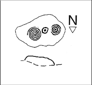
The Bastard, Campbeltown, Argyll

Hillfort / Dun:  OS Grid Reference – NR 7612 1220

Also Known as:

  1. Canmore ID 38722
  2. Dun Bastard

Getting Here

The Bastard on 1869 map

Pretty easy.  From Campbeltown, follow the coastal round south for about 8 miles, past the TV masts on the skyline and the hamlet of Feochaig, where you’ll see the large rounded hill on your left near the coast: that’s The Bastard!  Go onto the hill’s eastern sides and drop down the steep slope towards the large bend in the burn where its remains are on a ridge close to the cliffs overlooking the sea.  The ruins are pretty faint but if you scout around, you’ll find it.

Archaeology & History

I couldn’t believe it when I found this one – so had to get the notes to the site and add what I could find!  When the fellas from the Scottish Royal Commission checked the place in 1960, they described,

“On a narrow shelf halfway down the east flank of the hill named The Bastard there are the remains of a dun…  Oval in plan, the dun measures about 15m by 12m internally and is entered from the east, where a stretch of the outer face is visible. Here the wall is 4m thick on either side of a straight passageway, 0.9m wide, which exhibits no trace of door-checks.”
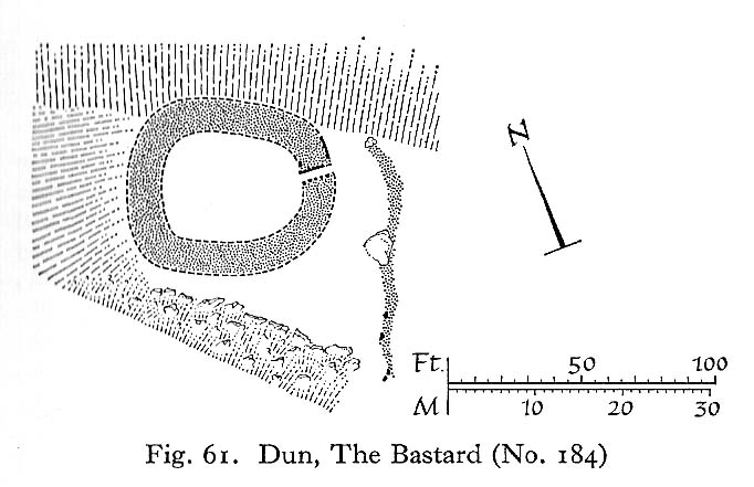
The Bastard (RCAHMS 1971)

There are other remains a few yards to the southeast of the main structure which are thought to be “remains of an outer wall…about 1.2m in thickness, which has been drawn across the shelf to provide additional protection for the entrance”, more probably from the weather conditions than invasive incoming humans.

To the immediate north we have a mythic-sounding Giant’s Seat (just above the natural arch) and west is the abode of the fairy folk – but I aint checked out the tales behind them yet.

References:

  1. Royal Commission Ancient & Historic Monuments, Scotland, Argyll – Volume 1: Kintyre, HMSO 1971.

© Paul Bennett, The Northern Antiquarian


Leathad Carnaich, Dalhalvaig, Caithness

Cairn:  OS Grid Reference – NC 89044 55882

Archaeology & History

An unexcavated ring cairn in a very good state of preservation can be seen in the field immediately west of the River Halladale.  Measuring more than 14 yards across east-west and 15 yards north-south, the site stands in association with several other unexcavated cairns.

Folklore

Although some of the cairns here have been found with prehistoric burials in them, tradition tells that the cairns here were the result of “a great battle between the native Pictish inhabitants and the invading Norsemen.” So wrote George Sutherland, many moons ago. He continued:

“The Norsemen were defeated in that battle, and Halladha, their leader, was slain. It is from him that the river and the dale take their name. The battle was fought on a hillside, on the east side of the river and that hillside is covered with cairns which are supposed to mark the graves of those slain in this battle, but the body of Halladha, the norse leader, was interred on the west side of the river, and his sword was laid in the grave beside his body. Near the circular trench where he is said to have been buried there are several heaps of stones which are supposed to mark the graves of other Norsemen of note who fell in the battle.”

References:

  1. Sutherland, G., Folklore Gleanings and Character Sketches from the Far North, John o’ Groats Journal: Wick 1937.

© Paul Bennett, The Northern Antiquarian

Middleton Moor Carving (006), North Yorkshire

Cup-Marked Stone:  OS Grid Reference – SE 12292 52144

Getting Here

Middleton Moor CR-006

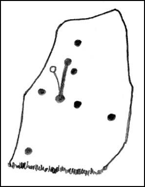
Another off-the-beaten track site!  Follow the directions to reach the Middleton Moor 001 carving, then walk due east for about 500 yards until you reach the distinct footpath that’s the Roman Road.  Once here, zigzag along its edge on the western side, up and down hereabouts.  Keep looking around till you see the stone shown in Richard’s photo here!

Archaeology & History

First found in April 2005, this medium-sized flattish stone is just 10 yards west of the prehistoric trackway which cuts across the moors  — later used as a Roman road — on Middle Gill Bents.  A somewhat simplistic design, it was found by Richard Stroud when we were exploring some of the many other carvings up here, and looking for previously unrecorded ones hiding in the heather.  Carved onto this stone are eight, perhaps nine cup-markings, with grooved lines connecting at least two of them.  That’s it!

© Paul Bennett, The Northern Antiquarian

Serpent Mound, Scallasaig, Glen More, Inverness-shire

Cairn:  OS Grid Reference – NG 848 202

Folklore

I’m presuming that this burial site is the right one, described in the fine Mr MacGregor’s Peat Fire Flame (1937) as being “by the roadside up near Scallasaig.”  There certainly doesn’t appear to be another alternative site close by (though if I’ve got it wrong, someone please lemme know!).  This place was, said MacGregor, a site “where the people in olden times used to worship the serpent.”

MacGregor spoke with a local man about the myths here and asked how long it had been associated with serpents.

“Och, about two thousand years,” said Mr John MacRae. “The mound was in the shape of a serpent, and when the chief of the people would die, he would be buried in the head of the serpent..”

He continued, saying, “One from London, that was going about searching things like that, opened the mound, and they found in the mound a big stone coffin with a big stone slab on the top. And there the bowl was found with the ashes of the chief of the people at that time. The bowl was taken to the Manse. That’s about fifty years ago. It was there for a few months; and they took it to Edinburgh, to some museum or something. They were saying that there was a funny noise in the Manse when the bowl was lying there. If there was any treasure in the bowl, or in the grave along with the bowl, it was taken out before. You see, had he any treasure – the chief like – guns and money and the like – I’m sure they wouldn’t be putting much money in the grave. It would be going into the grave with the dead man, so, when he would rise in the next world, he would be ready to start at the same game as he was carrying on here on Earth.”

This sounds a little like the folk-memory of an idea of a heathen afterlife – and of course it’d make sense finding such lore here at a tomb.

I’ve come across references to several other serpent mounds scattering the western side of Scotland, but their exact locations have proven hard to pin down. It makes y’ wonder how many more there once were before the christian paradigm became entangled in the myths of the country people.

References:

  1. MacGregor, Alisdair Alpin, The Peat-Fire Flame: Folk-Tales and Traditions of the Highlands and Islands, Ettrick Press: Edinburgh 1937.

© Paul Bennett, The Northern Antiquarian


Middleton Moor Carving (441), North Yorkshire

Cup-and-Ring Stone:  OS Grid Reference – SE 10887 51381


Getting Here

From the back of Moor End Farm on the south-side of Langbar village, follow the Long Ridge footpath up onto the moor. Walk along the path until its starts dipping down again, onto the moor proper and where another footpath crosses and goes down into the small valley of the Dryas Dike stream, follow it – though only for about 75 yards, heading diagonally into the heather slowly towards the stream.  You’re getting close!

Archaeology & History

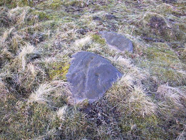
Crude drawing of CR441

Yet another small carving found amidst a decent cluster of cup-and-rings and other archaeological remains near the top of Dryas Dike, this stone was first described in the Boughey & Vickerman (2003) survey.  It’s located about 10 yards below Middleton Moor CR-440, above the stream of Dryas Dike.  It’s a simple design, comprising of a central groove with a cup at either end and several other cups either side of this central line.  (cheers to Richard Stroud for use of his photo).

References:

  1. Boughey, Keith & Vickerman, E.A., Prehistoric Rock Art of the West Riding, WYAS 2003.

© Paul Bennett, The Northern Antiquarian

Lee Hall Well, Bellingham, Northumberland

Healing Well:  OS Grid Reference – NY 861 797

Archaeology & History

Very little is known about this forgotten heathen water source.  It was described in some notes attached on a piece of paper accompanying John Warburton’s description of Lee Hall and its surroundings.  The notes were first printed in an early edition of Archaeologia Aeliana and subsquently included in Binnall & Dodds’ (1942) fine survey on the holy wells of the region.  It’s exact whereabouts appears to be lost, but it may be either the small pool across from the present Hall, or a small spring found in the edge of the small copse of trees just east of Lee Hall Farm.  Does anyone know?

Folklore

Written verbatim in that dyslexic olde english beloved of antiquarians like misself, the only piece of folklore said of this spring of water told:

“At the Lee hall an exclent spring, the vertue is such that if the lady of the Hall dip aney children that have the rickets or any other groone destemper, it is either a speedy cure of death.  The maner and form is as followeth: The days of dipping are on Whitsunday Even, on Midsumer Even, on Saint Peeter’s Even.  They must bee dipt in the well before the sun rise and in the River Tine after the sun bee sett: then the shift taken from the child and thrown into the river and if it swim…child liveth, but if it sink dyeth.”

The latter sentence echoing the crazy folklore of the christians to identify witches in bygone days!

References:

  1. Binnall, P.B.G. & Dodds, M. Hope, ‘Holy Wells in Northumberland and Durham,’ in Proceedings of the Society of Antiquaries of Newcastle-upon-Tyne (4th Series), 10:1, July 1942.

© Paul Bennett, The Northern Antiquarian

Crowbar Stone, Weetwood Moor, Wooler, Northumbria

Cup-and-Ring Stone:  OS Grid Reference – NU 021 278

Also known as:

  1. North Plantation 3
  2. Fowberry Moor Stone 3

Archaeology & History

Davison’s sketch

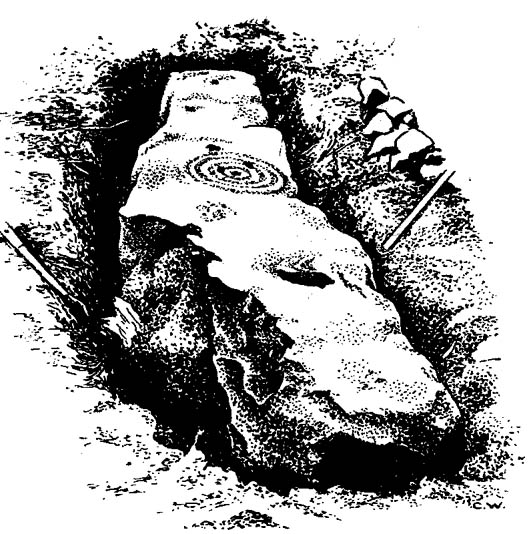
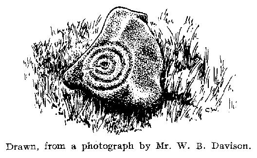
This is an excellent-looking carving which, it would seem, remains buried in the Earth nice n’ sleepy!  Located “in the inner rampart on the south side of an unrecorded camp in North Plantation, Fowberry Moor, Chatton,” the carving was unexpectedly found during some basic excavation work on the camp itself.  Described and illustrated by W.B. Davison (1934), this was one of two cup-and-ring stones hereby.  He reckoned it wasn’t in its original position and seems – from the illustration here – to have been etched onto a fallen monolith.  Davison’s detailed description told:

“The…stone was completely excavated and was found to be built into the inner rampart across its track.  This stone measures 7’6″ north to south, is 1’2″ wide at its north end, 1’11” at its widest part, and 1’3″ at its foot.  The average depth is 2’6″.  The base is rough-surfaced and is prow-shaped at the northern end.

“Incised markings occur on the top only, and are as follows, reading from north to south.  1 cup surrounded by a ring and a half-ring lying east to west by south.  1 small cup.  1 cup.  1 cup surrounded by four rings, the largest of which has a diameter of 13½”.  On the top of the outer ring occurs an abutting semicircle enclosing a cup.  On the accompanying (image) will be observed what appears to be another cup on the innermost ring.  1 cup.  1 cup surrounded by a ring and a half-ring lying north to south by west.  This marking rests on a two-inch deep slot possibly made for quarrying purposes.  No other markings occur between this slot and the foot of the stone.  Tool marks are very distinct on some of the above markings.”

Rock art researchers Jan Brouwer (2007) and Stan Beckensall have searched unsuccessfully for the stone in recent years.

References:

  1. Beckensall, Stan, Northumberland’s Prehistoric Rock Carvings, Pendulum: Rothbury 1983.
  2. Beckensall, Stan, Prehistoric Rock Art in Northumberland, Tempus: Stroud 2001.
  3. Brouwer, Jan, ‘In Search of the Crowbar Stone,’ BRAC 2007.
  4. Davison, W.B., ‘Cup-and-Ring Marked Rocks at Fowberry Park,’ in Proceedings of the Society of Antiquaries of Newcastle-upon-Tyne (4th Series), 4:7, October 1934.

© Paul Bennett, The Northern Antiquarian

Fowberry Moor Farm, Wooler, Northumberland

Cup-and-Ring Stone:  OS Grid Reference – NU 029 261

Also known as:

  1. Deershed Plantation Stone

Archaeology & History

This is a small but impressive stone, presently housed in the Musuem of Antiquities in Newcastle.  It was first mentioned by Mr H.L. Honeyman (1934) as being donated to Newcastle’s Society of Antiquaries by a Mr J.M. Strother of Fowberry Moor Farm in 1934.  He described the carving as,

“a sculptured ring-marked stone, 1ft 2in by 1ft 2in, bearing a cup with three rings and duct. Found in Island Plantation (camp), Fowberry Moor, Chatton, 22.7.34, by Mr Wake.”

Stan Beckensall (1983:127) described it in passing his early work on Northumberland rock art, then again in his updated edition.

References:

  1. Beckensall, Stan, Northumberland’s Prehistoric Rock Carvings, Pendulum: Rothbury 1983.
  2. Beckensall, Stan, Prehistoric Rock Art in Northumberland, Tempus: Stroud 2001.
  3. Honeyman, Herbert L., ‘The Society’s Meetings: July,’ in Proceedings of the Society of Antiquaries of Newcastle-upon-Tyne (4th Series), 4:7, October 1934.

© Paul Bennett, The Northern Antiquarian

Spring Stone Carving, Middleton Moor, North Yorkshire

Cup-Marked Stone:  OS Grid Reference – SE 11611 51610

Also Known as:

  1. Middleton Moor carving 483 (Boughey & Vickerman)

Getting Here

From Ilkley go up to Middleton and from there go up Harding Lane and, where the road bends left a track goes straight north onto the moors. Go up this until you’re onto the moor proper. Keep going until you’re following the line of walling, where a small stream is trickling right by your right-hand side. Follow this to its source a coupla hundred yards up. Stop!

Archaeology & History

Middleton Moor CR483: single cup-and-line

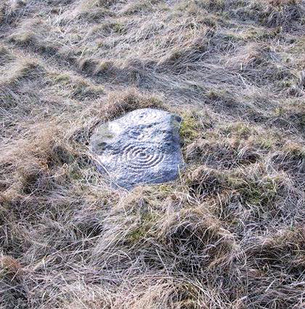
First mentioned by Stuart Feather in 1965, this simple cup-marking has a long line squirming away to the edge of the rock on which it’s carved.  The cup-marking is some 3 inches across and about ½-inch deep, with the long line about 24 inches long.  There’s really nowt much to look at here unless you’re a real cup-and-ring freak — though note that the carving occurs on a broken piece of stone just where a spring of water emerges from the ground.  Some archaeo’s have a notion that sometimes our cup-and-ring stones have some sorta relationship with water — though they’re not into sticking their necks out and saying anymore than that!  And of course, some carvings obviously relate to water. This one here is a strong contender, with the long wiggly line perhaps representative of the stream running from its source, which itself is the cup-mark.

However, we might just aswell surmise that the carving here was executed by some bored teenager, just testing out his first antler pick, or flintstone, telling his mates, “I woz ‘ere!”

References:

  1. Boughey, Keith & Vickerman, E.A., Prehistoric Rock Art of the West Riding, WYAS 2003.
  2. ather, Stuart, ‘Cup and Ring Boulders,’ in the Cartwright Hall Archaeology group Bulletin, 10:7, July 1965.

© Paul Bennett, The Northern Antiquarian

Middleton Moor Carving (482), North Yorkshire

Cup-and-Ring Stone:  OS Grid Reference – SE 11600 51455

Also Known as:

  1. Owl Carving

Getting Here

Multiple-ringed carving (© Richard Stroud)

Best approached from the south, up Hardings Lane, then where its bends and the track of Parks Lane goes onto the moor, follow it.  Onto the moor, keep on the track as it follows the walling until you reach the gate on your right.  From here you’re close: head into the grasses and heather (left) not far off the western edge of the footpath at the eastern end of Dryas Dike.  Look around!

Archaeology & History

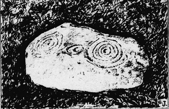
This lovely looking carving “quite near to the footpath and enclosed fields above March Ghyll reservoir,” was first described by Stuart Feather. (1965)  It can be found on a small flat stone and is easily obscured if the grasses are long – but it’s worth searching for.  It’s an archetypal cup-and-ring stone, consisting of a cup-and-five rings, a cup-and-ring, and a cup-and-three rings — though they are rather faint and can be missed in bad light.  As with other carvings, it’s best to splash water over it (as me & Richard did in the photo above) so you can see it a bit clearer.  Feather (1965) told us:

“The symbols are very fine, consisting of three cup-and-rings.  One of them, a quadruple, concentrically-circled cup with part of a fifth, unfinished ring.  The cup is very shallow, 1 inch across, and the circles…½ inch wide and shallow, with an overall diameter of 8 inch for the four circles; 9 inch with the other unfinished section.  The single cup-and-ring has a cup ¾-inch in diameter, ½-inch deep and a 4-inch diameter ring somewhat broader than the other rings on the rock and abutting on the north side against a slightly raised part of the rock surface.”

Sidney Jackson’s drawing
Boughey & Vickerman’s drawing

The triple-ringed cup is of similar dimensions to the larger example, with the cup being 1½ inch across and deep, with the circles being 7 to 7½-inch across.

About a half-mile northeast of here is the old Langbar Stone where I got the distinct impression that the same person was responsible for both of these carvings.  God knows why!

References:

  1. Boughey, Keith & Vickerman, E.A., Prehistoric Rock Art of the West Riding, WYAS 2003.
  2. Feather, Stuart, ‘Mid-Wharfedale Cup-and-Ring Markings: No.32-3, Middleton Moor,’ in the Cartwright Hall Archaeology group Bulletin, February 1965.

© Paul Bennett, The Northern Antiquarian