Along the main street running through Alva, towards Tillicoultry, watch out for the roman catholic church on your left, then shortly past it the house of St. Serfs. Just next to this is the small road called Lovers Loan. Walk up here and just before the graveyard, walk right, into the overgrown boggy marshlands. The first presence of the holy waters here are about 12-15 yards into the grasses, where you’ll walk right into it!
Archaeology & History
A sacred well that was named after the little known character of St. Serf, who was said to have been the hermit and tutor of the more renowned St. Mungo.
Highlighted on the 1866 Ordnance Survey map of the area as St. Servanus’ Well, 100 yards southeast of the church, it was included in MacKinlay’s (1893) fine survey, though without comment. However it was said by Mr & Mrs Morris (1982) to be “near the south entrance of the churchyard.” The boggy remains of the spring can indeed be found at the southern edge of the graveyard, up Lovers Loan, just below the edges of a large mound. In Mrs Drummond’s (1936) survey of Alva, she too told that the “Well of St Servanus”,
“contained healing waters and was still to be seen in St. Serf’s Glebe in 1845, nbut it is now just a marsh on the west wisde of the lower cemetrary gate.”
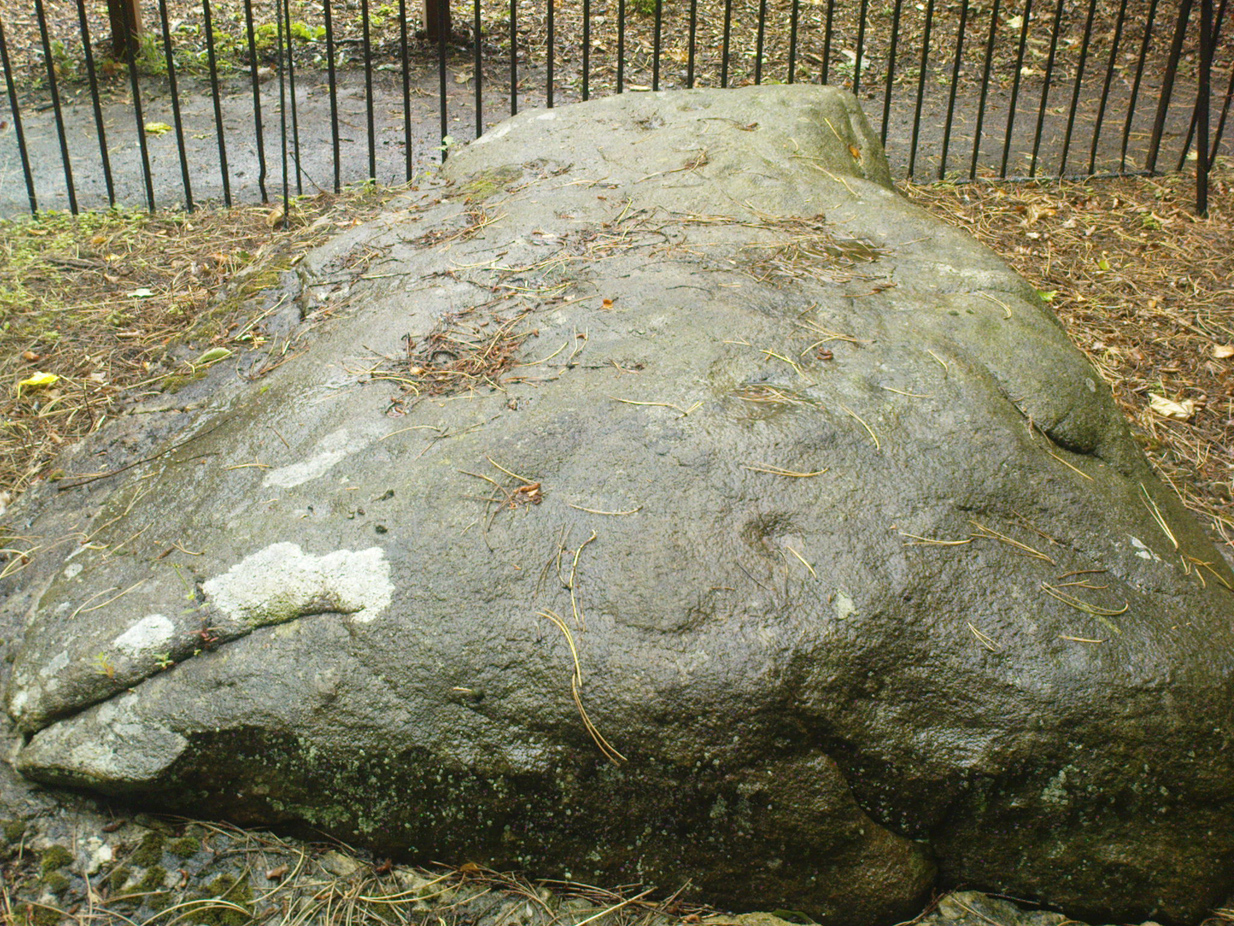
The original waters have in fact been completely capped and the well is now covered by a modern concrete block, standing right next to the resurrected remains of one of Alva’s remaining standing stones.
References:
Drummond, Mrs A., The History of Alva and District from the Early Christian Period to 1900, in Transactions Stirling Natural History & Antiquarian Society, volume 58, 1936 (reprinted by Clackmannan District Libraries 1981).
MacKinlay, James M., Folklore of Scottish Lochs and Springs, William Hodge: Glasgow 1893.
From the main road running through the town, head west towards Alva, and where the golf course begins, take the footpath uphill at its edge which heads towards the giant quarry. Where the dirt-track begins, keep walking along the edge of golf course, noting that where the open field starts, a gate on your right. Go through this, and walk up the side of the fence for some 30 yards, then go through the large gate. 10 yards in front of you, note the small stream crossing the track, and a scatter of overgrown rocks just on the other side of the wire fence. You’re here!
Archaeology & History
Thought by Angus Watson (1995) to have been possibly dedicated to ‘Our Lady’: in this context it’s difficult to know whether the dedication was to the christian Virgin, or to the heathen ‘Lady Alva’, whose web of snow and other natural garments clothe the mountains and glens of the Ochils hereby.
The first account of the place seems to be in William Gibson’s Reminiscences (1883) where he told that,
“In the year 1839, a Mr John Henderson built the only woollen mill…the water for the steam engine of which was got from the Ladies Well”,
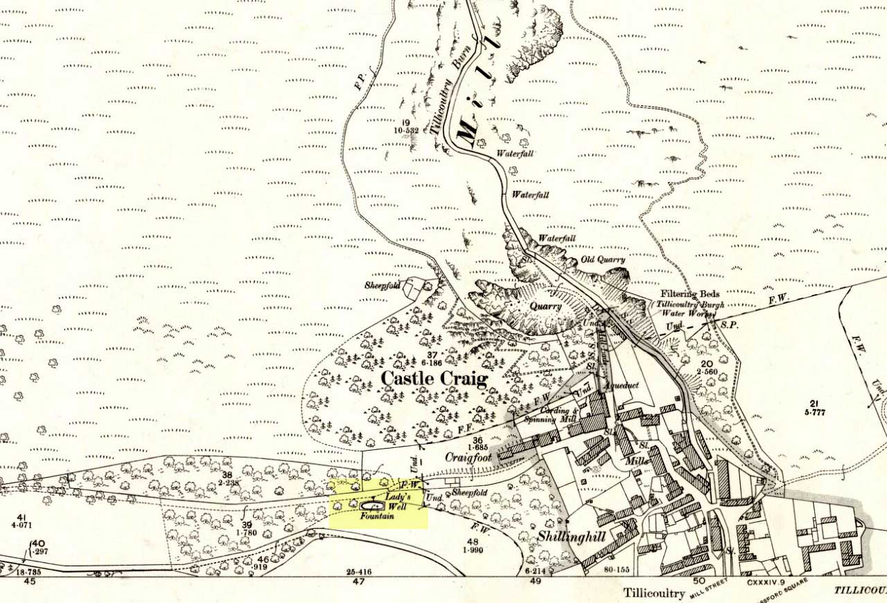
Ladys Well on 1899 map
which was barely 100 yards to the west. It was later highlighted on the OS-map in 1899 with an associated ‘fountain’, right by the track-side. A water-pumping station shown at the same time on another map was, of course, the one that was built to supply the mill with water.
The present water source is slightly higher in the field than when it was shown on the early OS-maps, and it does still flow continuously—although the source is much neglected and could do with being recovered: as the photo here shows, an ugly pipe appears to be taking much of the healing waters which are now mainly feeding a large pond in the garden just below.
References:
Gibson, William, Reminiscences of Dollar and Tillicoultry, Andrew Elliot: Edinburgh 1883.
Take the A820 road from Dunblane to Doune. About a mile west of the motorway, keep your eyes peeled for where the small road on your right is signposted to Argaty and Kilbryde. Stop here and walk up the footpath on the left-hand side of the road. A couple of hundred yards up, take the right turn on the track and where the small copse of trees is, go through the gateway, keeping yourself to the left edge of the trees running parallel to the field. About 100 yards or so up, you can’t miss him!
Archaeology & History
Quite a huge fella this one! Standing more than 6 feet high, the monolith is nearly as broad, giving an impression of great size to the old stone. The stone’s nature and date is troublesome: although ostensibly labelled as Bronze Age, alongside the walling which runs down from here we see a great number of other large stones, some of which give the distinct impression of being length of Iron Age walling — but without excavation, its nature remains a puzzle. The monolith stands close to being on top of a rise in the land, which geomancers understand as being important sites of spirit, or places where the dead were rested — but we have no record of any tombs here, so are left with the options of walling or a spirit site.
…and from another angle
On its east-face, the stone has a number of what appear to be curious large cup-markings, but they appear to be little more than the effect of weathering and erosion. There’s also a solid piece of long metal sticking out of the same side, which was obviously done by someone in recent centuries — so maybe a local farmer and his mates stood this one up? Or they were planning on using it as a gatepost…
The site is well worth looking at, best in the winter months when access is easier. It has the feel of other sites close by, hidden from the record books, though probably long gone.
References:
Royal Commission on the Ancient & Historical Monuments Scotland, Stirling – 2 volumes, HMSO: Edinburgh 1963.
Royal Commission on the Ancient & Historical Monuments of Scotland, Archaeological Sites and Monuments of Stirling District, Central Region, Society of Antiquaries of Scotland 1979.
One helluva climb to reach this little fella. I simply started at Dalgirdy cottage, some 5 miles along Glen Lochay, on the right-hand side of the road. Then, walk right up the burnside, all the way up until it begins to level out and the old shielings appear. When you’ve got to where they just about finish, about 50-70 yards on the east side of the burn, you’ll see the small stone standing upright, all alone. You can’t really miss it!
Archaeology & History
Allt Ghaordaidh, looking south-ish!
No previous written records exist that describe this small standing stone, whose nature and age may be akin to that at nearby Tirai, found amidst the derelict village a couple of miles east, lower down the slopes — i.e., it may have simply been part of some of the ancient village remains and shielings found close by, either side of the rushing burn. But whether it’s only medieval or much more ancient than that, its position in the landscape alone (much like Tirai’s uprights), deserves to be known about.
There are considerable amounts of ancient remains scattering the mountains slopes all round here: some have been catalogued, but a lot of it has not. This little standing stone is at last alive again! (take good food and kit when visiting here)
From Thackley corner, take the Esholt road down Ainsbury Avenue. Walk past the Thackley football ground and another 50 yards on, to your left, there’s a field. Cross this and go through the gate into the trees. Another field is across the footpath, but turn right and walk on the muddy path, keeping parallel with the other field, until the walling bends round to the left. About 15 yards round where the wall bends left, watch out for the silver birch tree and the small cup-marked rock at its base, right up against the wall.
Archaeology & History
This is an archetypal single cup-marked stone known as a ‘portable’ — though in its original state, when the rock was obviously larger than it is today, I doubt anyone could have carried it further than a couple of yards! The stone has been split from a larger rock, and we’re unsure the size of its original form—but presume it to have been perhaps double its present size.
The broken rock stands (now) upright against the wall and nice birch tree (Betula pendula), but wasn’t like that when we first found it, and the cup was barely visible as it faced down into the Earth. As the images show, we have just a single cup-mark on its outer face. It looks typical of those carvings found in the larger Bronze Age cairns scattering the moors to the north, but we have no evidence nor folklore indicating the existence of such a monument hereby. The extensive amount of overgrown multiperiod walling all over this woodland may have used up such a cairn, but we will probably never find out, as the woods have been overused by industrialists, who are now, slowly, turning the woods here into a park.
From Thackley corner, take the Esholt road down Ainsbury Avenue. After a couple of hundred yards, note the metal gateways into the woods. Go through here, following the main path, until you reach another split in the paths where one of those awful touristy signs tells you where you are. Walk past this (not left or right) into the opening of large oaks and other trees on a flat plain. A path swings round the right side of this, and less than 100 yards along, watch out for some rocks on your right, heading towards the wall and small field. You’re damn close!
Archaeology & History
Close-up of cup-markings
This is one amongst a cluster of at least five cup-marked stones very close to each other in the woods here — and probably the best of the bunch. Also found in conjunction with what seems to be an Iron Age walled enclosure 20 yards away, there are at least eight cup-marks on top of this rock, They occur in two groups: one, on a sloping section of the boulder where three fading cups can be seen; and the other is on the topmost section of the stone, where five larger cups distinctly stand out, and occur in conjunction with what seems to be a long carved line running close to the edge of the rock before it drops sharply to the ground.
This and its associated carvings are found in close proximity to some sort of walled enclosure. It’s difficult ascertaining the age and nature of the enclosure walling, as masses of it are found throughout this section of woodland and it appears to be multiperiod in age and nature: from Iron Age to Victorian by the look of things. Neither this cup-marked stone, nor any of its close associates (the closest of which is the Buck Woods 3 carving, less than 10 yards away), were recorded in the Boughey & Vickerman survey of rock art in West Yorkshire.
Although cited in all modern archaeology texts as a series of four henge monuments, a recent article by J. Lewis & D. Mullin (2011) inform us that these “are not henges but belong to a tradition of enclosure that predates them and had a different function.” We’ll have to wait and see what they mean by that! In the meantime, we’ll have a quick scurry through the historical accounts of these four impressive ‘henges’ as Burl, Piggott and the others call ’em.
Surrounded at all angles by numerous barrows and tumuli, these four great henge monuments were shown on the 1887 Ordnance Survey map as a row of ‘Supposed Ring Forts’, when such ideas were in vogue, running in a line roughly SSW-NNE; the third one up having a couple of ponds within it. A brief early account of them was given by Harry Scarth (1859)—who was describing the series of nine round barrows a few hundred yards to the south—who told them to be “circular banks” each 500 feet across. The first more detailed account was in A.H. Allcroft’s (1908) classic text, where he wrote the following:
“…Close to the Castle of Comfort Inn, where the high road to Bristol crosses the line of the old Roman road running north-westward towards Charterhouse, there lies immediately west of the high road a series of four circles…all of one size, all of one plan, and all as mathematically exact as circles could well be when executed in such a soil and on such a scale. Although they have suffered greatly from the mining operations which have scarred all the Mendips, as well as from the plough — one of the four is almost obliterated — they are still quite easy to make out. The diameter of each is some 550 feet within the area, which is surrounded by a broad low vallum, and that again by a correspondingly broad and shallow ditch. The height of the vallum above the ditch, where best observable, is some 5 feet. There are no determinable entrances. The most southerly of the group is about 250 feet away from the second ; the second about 200 feet away from the third; and a line joining the centres of the first and third passes through the centre of the second also, and points 17° east of north. The fourth circle lies 1,200 feet away from the third, not in a right line with the others, but slightly to the west. Between the third and fourth circles passes the Roman road. Within the third circle is an old pond of some size.
“With every appearance of being all of one date, and that a venerable one, these circles lack every characteristic of military works. Their peculiar disposition, their painstaking regularity, and their identity of size, all suggest that they must, if really old, be of ritual, and perhaps of astronomical character”
Old drawing of the central hengesHenge 1, recently damaged (courtesy Pete Glastonbury)
Allcroft’s ideas of ritual and astronomy were pretty good for the period, as we take it for granted these days that such events occurred at henges — so the existence of four such sites right next to each other, would have made this one helluva place in neolithic and Bronze Age periods. A few years after Allcroft, the henges were described in Mr Burrow’s (1924) excellent illustrated survey, from which the drawing of the two central henges is taken (the two ‘R’s in the background highlight the line of the Roman road which runs past them). Burrow’s didn’t add much more of any note, simply telling:
“…in the fields north and south, are placed earth-work rings, each about 180 yards in diameter, on a line placed slightly north by east. The most northerly of these rings is almost obliterated, but the three on the west of the road from Chew Stoke to Oakhill are quite clearly defined, as my drawing (above) will show. I have been able to include two of these remarkable rings in my picture, the edge of the bank (which was, when I saw it, fringed with yellow gorse), being about 6 feet above the level of the ditch outside. It is generally supposed that these ringed earthworks were connected with some prehistoric ritual, and Hadrian Allcroft thinks were used for primitive astronomical observations or the construction of a primitive calendar.”
Tratman’s plan of Priddy HengesAnother view of Henge 1 (courtesy Pete Glastonbury)
Many years later when archaeologist K.S. Painter (1964) came to describe these henges, he listed them as “stone circles” (what the hell was he on!?), but this error may derive from the finding of several stones that once existed inside the southernmost Henge 1. These were uncovered following excavation work done here by E.K. Tratman (1967) and his colleagues, who explored and numbered the four henges—running from south to north—as follows:
“Circle 1: This is tolerably complete. A portion of the southwest quadrant has been destroyed by mining and there are three modern gaps in the ring. Mining has involved the ditch on the west and south, and to a small extent on the east. There is an irregular extensive hollow west of the centre and this too is a product of mining and contains a number of large stones so derived. The circle is not quite a true one, being flattened slightly on the west. The circle has a diameter from bank top to bank top of 520ft. The single original entrance is NNE of the centre. Stones 1 and 3-7 were removed by the farmer before excavation, but subsequent ploughing immediately after removal did not reveal any change in soil texture or colour. Stone 8 was placed in its present position quite recently. It is not known where it came from. Other stones have recently been placed on top of the bank east of the entrance by the farmer (1964-5). Stone 2 is in a relatively ancient position.
Circle 2: This is a true circle and its diameter and position of its entrance are similar to Circle 1. It has been considerably disturbed by mining. A group of stones (10-14) and stone 9 represent modern collections from the field. None of them is in its original position. There are two modern gaps in the ring.
Circle 3: This is distinctly flattened on the east and west. The N-S diameter is 520ft and the E-W 490ft from bank top to bank top. The northeast quadrant reported by Allcroft as being levelled is still traceable. The circle has been greatly disturbed by mining… The entrance is SSW of the centre, the opposite pole to circle 1 & 2, and has probably been widened, perhaps by miners. The marsh may be an original feature or the product of mining. The two ponds are certainly modern, and so is a small mound, which is probably spoil from the major pond.
Circle 4: This is incomplete. It has a diameter of 560ft, which is considerably larger than any of the others. The OS map shows only the eastern semi-circle remaining. However, the bank and in part the ditch can be traced…If the visible and proved end of the ditch on the SSW was intended to be at the edge of the causeway, then the entrance would have been in the same position as that of Circle 3.”
Very recently, a local land-owner quite deliberately bulldozed a large portion of the southern henge in this complex, destroying much of it. This act of criminal vandalism will hopefully not go unpunished and is, at the present time, going through the courts.
…to be continued…
References:
Allcroft, A. Hadrian, Earthwork of England, MacMillan: London 1908.
Burrow, Edward J., Ancient Earthworks and Camps of Somerset, E.J. Burrow: Cheltenham 1924.
Lewis, J. & Mullin, D., “New Excavations at Priddy Circle 1, Mendip Hills, Somerset,” in Proceedings of the University of Bristol Speleological Society, volume 25, 2011.
Painter, K.S., The Severn Basin, Cory, Adams & Mackay: London 1964.
Scarth, Harry M., “Some Account of the Investigation of Barrows on the Line of the Roman Road Between Old Sarum and the Port at the Mouth of the River Axe,” in The Archaeological Journal, volume 16, 1859.
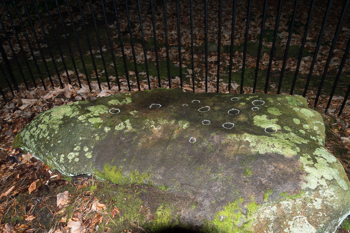
Come out of Ilkley/bus train station and turn right for less than 50 yards, heading left up towards White Wells. Go up here for less than 100 yards, taking your first right and walk 300 yards up Queens Road until you reach the St. Margaret’s church on the left-hand side. On the other side of the road, surrounded by trees is a small enclosed bit with spiky railings with Panorama Stones 227, 228 and 229 all therein: the least-decorated one on the left being the one we’re dealing with here.
Archaeology & History
This is another of the caged Panorama Stones, found within the awful spiked fencing across from St. Margaret’s Church, just out of Ilkley centre. Originally located ¾-miles (1.2km) WSW of its present position in Panorama Woods (at SE 10272 46995), along with its petroglyphic compatriots in this cage, the carving was moved here in 1890 when a Dr. Little—medical officer at Ben Rhydding Hydro—bought the stones for £10 from the owner of the land at Panorama Rocks, as the area in which the stones lived was due to be vandalized and destroyed. Thankfully the said Dr Little was thoughtful and as a result of his payment he had some of the stones saved and moved into their present position.
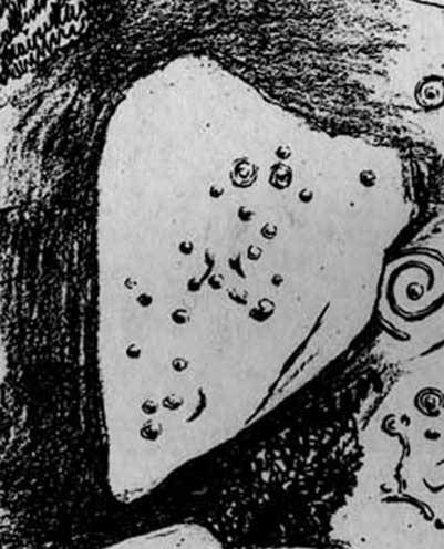
Original location of stonesJ.T Dale’s 1879 sketch
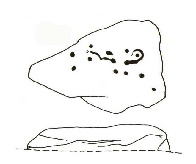
It was first described by the northern antiquarian and petroglyph pioneer, J. Romilly Allen (1879) , who saw it in the now-destroyed “rough inclosure”, as he called it, along with the other stones now in the same Ilkley ‘cage’. Its present position does it no justice whatsoever in terms of its original position. It was ostensibly a rocking stone: this seemingly trivial-looking boulder was sat on top of the much-cropped Panorama Stone 228 (a yard east of the three in this outdoor cage). Allen (1879) was fortunate enough to have seen the stone before it was uprooted, telling us how this topmost stone, “has eleven cups, wo of which are surrounded by single rings.” The modern archaeologist John Hedges (1986) told it to be in a “bad state,” with “very worn carvings, fourteen cups, one with partial ring and groove.” Its situation deteriorated further, as stated by rock art students Boughey & Vickerman (2003), who noted,
“medium-sized, roughly triangular rock, its surface recorded as in a bad state in 1986 and now (2002) even worse. Fourteen cups, one with partial ring, one groove.”
And its condition isn’t helped by its inaccessibility, when groups like the ‘Friends of Ilkley Moor’ or the local archaeologist should be at least annually cleaning this and the adjacent carvings. If they’re incapable, there are sincere people in antiquarian, history and pagan groups who would probably help out…
John Hedges 1986 sketchFaint cupmarks visible
In truth, this carving cannot be seen in isolation, nor merely reduced to a numeric catalogue in some rock art corpus. We must contextualize its relationship with the once much-larger multiple cup-and-ring stone on which it sat and then see it as it was in the landscape. Originally of course the rocking stone was Nature’s very own creation. As humans began migrating over and eventually occupying this once-wooded arena, the rocking stone became intimately related with animistic magickal rites and, over time, petroglyphs began to be etched upon the stone. Most probably the flat underlying rock surface was carved upon first, and a symbiotic relationship was forged between Earth’s surface and the small rocking stone, both of which were used in oracular and other rites. Over centuries, as the cups and rings on the earthfast stone grew, the mythic status of this small rocking stone allowed for the encroachment of carvings, and eventually cup-marks began to be etched upon it too. Later still, as the neolithic period moved into the Bronze Age, the people began to build a low-walled stone enclosure around this and the nearby multiple-ringed carving – similar to the multi-period enclosure at Woofa Bank and other sites on these moors. It was all a very long and gradual process.
In truth, the mythic status of this once-impressive site would have been maintained—in one form or other—well into the medieval period. But that’s another matter altogether…
Bennett, Paul, The Panorama Stones, Ilkley, TNA: Yorkshire 2012.
Bennett, Paul, Aboriginal Rock Carvings of Ilkley and District, forthcoming.
Boughey, Keith & Vickerman, E.A., Prehistoric Rock Art of the West Riding, WYAS: Leeds 2003.
Cowling, Eric T., Rombald’s Way, William Walker: Otley 1946.
Downer, A.C., “Yorkshire Archaeological and Topographical Association,” in Leeds Mercury, August 28, 1884.
Eliade, Mircea, The Sacred and the Profane: The Nature of Religion, Harcourt, Brace & World: New York 1959.
Hadingham, Evan, Ancient Carvings in Britain, Souvenir Press: London 1974.
Hedges, John, The Carved Rocks on Rombald’s Moor, WYMCC: Wakefield 1986.
Heywood, Nathan, “The Cup and Ring Stones of the Panorama Rocks”, in Transactions Lancashire & Cheshire Antiquarian Society, Manchester 1889.
Speight, Harry, Upper Wharfedale, Elliott Stock: London 1900.
Acknowledgements: With huge thanks to both Dr Stefan Maeder for help in cleaning up the stones; and to James Elkington for allowing use of his photos in this site profile.
The holy well/spring can be reached by following the Worsthorne road south from Haggate to Cockden Bridge over the River Don, then following the footpath due east beside the river for about a quarter of a mile. At the Ormroyd footbridge where the River Don becomes Thursden brook head in a north-easterly direction up the hillside. The well, or what’s left of it, can be found beside a trackway.
Archaeology & History
Around twenty-five years ago Calf Hey Well was described as being a square-shaped structure made of five stone slabs, one of which makes the roof. The water, which most probably had some form of mineral content, bubbles up into the large square basin which is a little lower than ground level. Today, the well is still there but I don’t know in what condition it is.
Folklore
According to Clifford Byrne in his book The Holy Wells and Mineral Springs of N.E.Lancashire,
“Calf Hey Well is a strong spring which rises out of the hillside, but in medieval times it was believed that the waters here had special qualities. Some people thought it was a holy well and reputedly many people visited Calf Hey on holy days when jugs of water were sold. A few accounts state that stalls were set up on a flat piece of land to the west of the well, Here vendors not only sold water but other things (food, religious objects and trinkets) and a market atmosphere must have pervaded the site”.
In 1819 the local water company took over the well and began to use its supply of water for the ever growing population of Burnley a few miles west of here. After this the fairie people were never seen again at the well – they were probably feeling very indignant at what had transpired.
Folklore has played its part here too. Fairies are said to have inhabited the well in days gone by – indeed they were often seen dancing around the well in the moonlight. These fairies or “little people” were not just creatures of the night which our ancestors delighted in when they could catch a rare glimpse of them. In fact these little people were quite normally formed although small in stature. Though not human they had the capacity to intervene in our human affairs – usually but not always for the good of it. They were known to steal little children and babies, supplanting them with their own offspring. So the parents of newly born babies had to be very vigilant and get their babies baptised as quickly as possible.
There are a few lesser-known wells in the same area as Calf Hey. These include The Jam Well at Worsthorne, Sweet Well at Holden Clough and Robin Hood’s Well at Black Clough, Thursden.
References:
Byrne, Clifford, The Holy Wells and Mineral Springs of Northeast Lancashire, MS copy in Nelson Public Library (Reference).
Frost, Roger., A Lancashire Township – The History of Briercliffe-with-Extwistle, Rieve Edge Press: Briercliffe 1982.
From Ilkley centre, take the road up to Cow & Calf, going past the hotel and along Hangingstone Road for a half-mile until you meet some walling on the right of the road. Stop and walk up the small beck, veering to the left as you approach the brow of the hill. Keep walking up the beck onto the moor where you’ll eventually reach its source, as shown in the photo here!
Archaeology & History
This once fast-flowing spring of fresh sparkling water has seen better days. The site has two openings in the Earth about 10 yards east and west of each other, both discernible by the notable difference in vegetation on the moors here, where richer hues of green created by the waters cut a small channel down the moorland slopes through the usual hues of heather.
The waters taste fine when they’re in flow, but much of the land here has fallen into shallow marsh and with the inevitable falling of the water table thanks to the stupid arrogant Industrialists, very little of the goodness is available. But it wasn’t always like this. Certainly when our prehistoric ancestors carved the rock art close by the source of the waters, then later constructed the large ritual enclosure immediately west of the springs, the waters would have been very important—and in much greater profusion—for simple nourishment and for rituals enacted at the site.

002")


")
")

")
")

")