Take the road from Ilkley town centre up towards the White Wells and keep following it along until it curves up and onto the moor itself and becomes a rocky dirt-track. Go up here, past the old quarries (left) until you hit the footpath which runs east (left) onto the flat level of the moorland. Follow this footpath along for literally half-a-mile, where a footpath runs up onto the tops of the moorland. Go up here for 100 yards and you’ll see a small standing stone by the right-hand side of the footpath; on the left, into the moorland about 20 yards away, this carving is to be found!
Archaeology & History
This is an excellent, archetypal cup-and-ring stone carving and is in a very good state of preservation. Found just a few yards away from the aptly-named Pitchfork Stone, the carving here on a large single stone mainly comprises of a double cup-and-ring. A couple of other possible outlying cup-marks can be seen: one just below the double-ring, and the other towards the top-end of the rock. It was first reported by Stuart Feather in the Bradford Archaeology Group’s journal in 1961, then listed in the surveys of Hedges (1986) and his followers.
Carving 257, looking NE
When Michala Potts, Dave Hazell and I we visited this carving the other day, some halfwit had been up here in the not-too-distant past and, as with some of the carvings on the moors north of Ilkley, had daubed some paint or oily resin onto the carvings themselves to specifically highlight aspects of the carved rock (not one part of the uncarved stone had anything on it). We aint quite sure exactly what the substance is that’s been daubed onto the carvings (it aint ordinary paint), but seems like an oil or industrial substance. And, whoever’s done this, obviously seems to have some knowledge of the rock art they’re painting over: they certainly have good grid-references and enjoy walking the hills. This aint just some idiot/s into vandalizing the carvings for the sake of it, nor the whim of some airy-fairy New-Ager. Whoever’s done this (and it’s been done on other cup-and-rings around this locale) have deliberately set out to locate and paint over specific carvings — a number of them off-path — with the intention it would seem to highlight them for photographic enhancement. So — whichever retard has done this, might I suggest that you keep your industrial waste where it belongs: in your own house you fucking moron! If anyone knows who is doing this to the carvings round here, please email me (anonymously if necessary) with all relevant info. Any such communications regarding this matter will be kept strictly confidential.
References:
Boughey, Keith & Vickerman, E.A., Prehistoric Rock Art of the West Riding, WYAS: Leeds 2003.
Hedges, John, The Carved Rocks on Rombald’s Moor, WYMCC: Wakefield 1986.
Walk up from Ilkley to the White Wells and keep following the footpath upwards, up the steps and onto the moor itself. Once you’ve got to the top of the steps above the rocky valley, look straight up the slope in front of you and walk directly up the hill. As you near the top, there’s a large cairn sat on the brow of the hill (known as the Coronation Cairn). This ‘ere carving is just a few yards below it.
Archaeology & History
Very little has been written of this albeit innocuous carving — if indeed it is a carving! Found on the large (though overgrown) flat stone just a few yards below the Victorian cairn, all that we appear to have here is a large cup-marking with a small arc pecked around its southern side and a distinct straight line running outwards from the cup (though the line doesn’t actually touch the cup-mark and does give the distinct impression of being pretty recent). A sort of “cup-and-half-ring” with extended line is perhaps the best description!
Close-up of cup & linesCarved Stone 270
It was first reported by some English Heritage archaeologist — which, as is generally acknowledged, isn’t necessarily a good pointer for authenticity when it comes to identifying prehistoric rock art.* But it’s certainly got a bit more about it than some “carvings” they’ve reported in the past! Boughey & Vickerman (2003) made the following notes of this stone:
“”Low, flat gritstone rock quarried away on E side, fairly smooth but uneven. One large cup and deep groove slightly curving round edge of cup.”
Which is about right. I don’t really think too many of you will be into this unless you’re a real rock-art fanatic!
References:
Boughey, Keith & Vickerman, E.A., Prehistoric Rock Art of the West Riding, WYAS: Leeds 2003.
Hedges, John, The Carved Rocks on Rombald’s Moor, WYMCC: Wakefield 1986.
* A number of cup-marked stones identified by English Heritage archaeologists have transpired to be nothing more than natural erosion.
From Skipton centre get to the Horse Close estate on the southern side of the town and look up to the fields on the sloping hill above it with the small woods above ’em. Head up towards the trees, but before you get there go into the fields on your right, and in one of them you’ll see what looks like a pile of rocks near the middle. Head for it!
Alternatively, follow the directions to reach the Horse Close Hill enclosure, then walk down into the field on its western edge. You can’t really miss it!
Archaeology & History
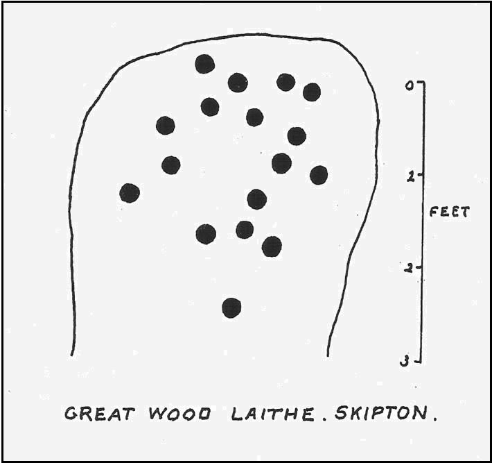
This carving first saw the light of pen-and-paper in the early 1960s, soon after the Yorkshire antiquarian Eric T. Cowling (he of Rombald’s Way fame) was led to the site by his wandering nose and the aid of local people. He sent a letter to the editor of the Bradford archaeology group at the time (a certain Mr Sidney Jackson), which told:
“South-west of the wood which gives its name to the Great Wood Laithe at the western end of Rombalds Moor and overlooking Skipton from the east, is a cup-marked boulder: NGR – SD 99625055. In the middle of the field alongside the wood is an outcrop of rock which has been almost levelled with the adjacent field surface by the dumping of boulders from the surrounding ploughlands.
“The top of the outcrop rises to a dome-shaped projection which bears simple cup-markings. These average two in diameter and total 17 in number. The whole surface of the stone is weathered, and suitable light may reveal more details.”
And, faded though it is, in better lighting conditions it seems there may be more than twenty cup-marks on the rock. Certainly this is what the surveys of Hedges (1986) and Boughey & Vickerman (2003) concluded. There are other carvings close by and, on the hillside immediately above you, the denuded remains of a very impressive prehistoric settlement site known as Horse Close Hill. Well worth having a look at!
References:
Boughey, Keith & Vickerman, E.A., Prehistoric Rock Art of the West Riding, WYAS: Leeds 2003.
Cowling, E.T., “Cup-and Ring Boulders,” in Cartwright Hall Archaeology Group Bulletin, 9:5, May 1964.
Hedges, John (ed.), The Carved Rocks on Rombald’s Moor, WYMCC: Wakefield 1986.
Pretty simple. Get to the chapel in front of Marlborough College, and look at the stepped hill in the grounds thereof (with a big hole cut into the top where a water tower once stood). That’s it! Please be aware that this monument is on college ground, so it might be worthwhile telephoning them if you wanna wander upon the hill.
Archaeology & History
Merlin’s Mount (from Colt-Hoare’s Ancient Wiltshire)
This curious rounded, pyramidal hill is thought by some to have given the town of Marlborough its very name. Described in Domesday as ‘Merleberge’, which is reckoned to derive from “the hill or barrow of Maerla”: Maerla in this case being a lost olde English name, said in local folklore and tradition to have been our old heathen magickian, Merlin, of Arthurian fame and legend. Long ago his bones were laid to rest here and this great ‘tomb’ built over him. We might never know…
The exact nature and date of this mound has yet to be satisfactorily explained. Commonly ascribed as Norman in origin (based mainly on the notion that it wasn’t mentioned before Domesday and there being motte and bailey ruins here), the finding of Roman remains near its base then led some to think they had built the hill; but when “antler picks used by its prehistoric builders were unearthed in the late nineteenth century and again in 1912 when a trench was cut for the flue of a new engine-house chimney” (Burl 2002), the dates for its origin went a lot further back!
One of the earlier commentators on this archaeological curiosity was Sir Richard Colt-Hoare (1812) in the days when much more of this and other sites were visible in the landscape, saying:
“The Mount within the gardens of the Castle Inn is a remarkable earthwork: it is a huge pile of earth, and inferior in proportions only to Silbury Hill. Each is situated on the River Kennet; the one near its source, the other near its margin; and I have no doubt but that in ancient times each had some corresponding connection with each other.”
A sentiment echoed by our modern megalithic scholar, Aubrey Burl. (2002) But as Burl points out, the distance between Silbury and Merlin’s Mount would have been measured not in distance by those who constructed these giant mounds, but in time. And the focus of our ancestors here in relation to these two great artificial mounds, would not be esteemed as much by engineering or measurement — for both mounds are gigantic — but a wholly mythic one. Colt-Hoare continued:
“This mound has been so mutilated, as well as lowered in its height, that it is impossible to calculate an exact measurement of either its circumference or height; but as nearly as we could guess with our chains, we found the base to be about 1000 feet in circumference, and the diameter of the summit 100 feet.”
A piece of Merlin’s Mount!
When the reverend A.C. Smith (1885) described Merlin’s Mount — or ‘Marlborough Hill’ as he preferred it named — more than seventy years later as, “an artificial tumulus which deserves careful examination”, it seems little further investigation had been done. And despite Smith’s wish for such care and attention, even today no detailed archaeological investigation has been undertaken. Astonishing! This fascinating-looking pyramidal “barrow” was thought by several early writers to have been constructed along similar architectural designs as that of Silbury Hill. In Massingham’s (1926) fascinating Egyptian-origin hypothesis, he tells us the following:
“Merlin’s Mount encompasses only an acre-and-a-half of ground in comparison with Silbury’s five-and-a-half, and reaches a trifle more than half its height (60 feet). In every other respect the twain are alike. Both were raised at the foot of a gentle slope, both were made of chalk resting on a thin layer of clay, both were trenched around the bases, and in both were buried the antlered picks of the builders. Both were built near the banks of the (River) Kennet within five miles of one and other.”
It certainly is impressive! When Michala Potts and I came here last year in the fine company of Pete Glastonbury and others, we were somewhat in awe of the fact that so little has been said of this site in modern archaeological terms. Indeed, the fact that the jury is still out as to the age of its construction we found quite surprising at the time. Though another quick reading of Mr Burl’s Avebury work, combining the Roman finds and the antler picks here, makes him think that “a prehistoric origin for the mound likely.”
The name of Marlborough itself has been given a number of interpretations, most notably the attempt to derive it from the great shaman-poet Merlin. But on a down-to-earth peasant level we find, in John Aubrey’s Monumenta Britannica there’s a note in the margin concerning the ‘marl’ element in the place-name that was told to him by a local man called Edward Leigh, which said,
“Marga, marle, we use instead of dung to manure our ground. It (Marlborough) lieth near a chalky hill, which our ancestors knew. They borrowed this name ‘chaulk’ of the Latin, calx, named marle.”
More recently Margaret Gelling (1984) thought that the name of this hill or mound “is variously interpreted as a plant-name or a personal name.” Which for some brings us back to Merlin! We might never know…
References:
Best, J., “The Marlborough Mound,” in A. Whittle’s Sacred Mound, Holy Rings (Oxford 1997).
Burl, Aubrey, Prehistoric Avebury, Yale University Press 2002.
Field, David, Brown, Graham & Crockett, Andrew, “The Marlborough Mound Revisited,” in Wiltshire Archaeologial & Natural History Magazine, 94, 2001.
Gelling, Margaret, Place-Names in the Landscape, Phoenix: London 1984.
Hoare, Richard Colt, The Ancient History of South Wiltshireand the Ancient History of North Wiltshire, London 1812.
Massingham, H.J., Downland Man, Jonathon Cape: London 1926.
Smith, A.C., Guide to the British and Roman Antiquities of the North Wiltshire Downs, WANHS 1885.
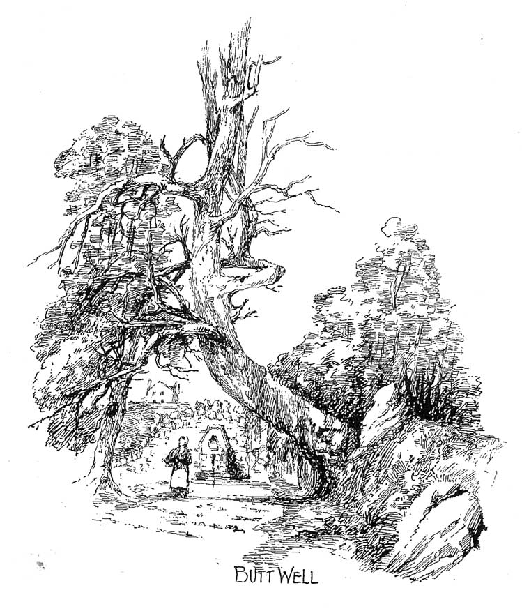
Said by John Allan (1907) to be “at the base of the Brandy Hill, about 210 yards west from the parish church,” to get to it from the town centre Stirling Arcade, go across and along the Corn Exchange Road and as it goes down the slope, take the path that leads into the trees on your right-hand side. Follow this path along to the bottom of the woods. Once on the level at the bottom, walk on the path in the direction of Stirling Castle and eventually you’ll reach the fancy walling with the dried-up well right in front of you!
Archaeology & History
This much-neglected site got its name from there being a number of archery shooting targets, or butts, which used to be erected in the fields immediately below this once popular drinking spot. Although the Stirling historian J.S. Fleming (1898) could find no definitive records of the place as a holy or healing well, he told how,
“The copious spring arising in the centre of the rock on which Stirling Town and Castle are built, must have been extensively used during the Royal occupation of the Castle for watering the horses engaged in hunting in the Park…and it must also have been the source from whence the canal or ornamental waters and fountains in the ancient pleasure-grounds of the King’s Knot were supplied, the fall being amply sufficient for the rise to a considerable height of the latter… The Well had at one time a railing surroundings its then open trough, the marks of the lead used in grouting the rails remaining visible until the last alteration.”
The waters emerging in the field belowThe Butt Well
Early accounts of the Butt Well are few and far between. Ronald James (1899) found it to have been known in earlier centuries as the Spout Well in 1582, but additional descriptions of the place are scant. The well is not included in the surveys of either MacKinlay (1893) nor the Morris’ (1981), though John Allan (1907) thinks that this site was a “congenial retreat” where “the bard of the chief” would gain insight. The remains of walling behind the old well he thought may have been the ancient remains of an old hermitage of sorts, but there’s little evidence to prove this. Today, although dried-up, the site appears much it as did when Fleming described it:
“The Well has had the old wall — formed of granite boulders — rebuilt and cemented, and a rustic ornamental freestone front put on where the spout is inserted, but its stone seat for invalids and other surroundings remains as they were forty years ago. The Well formed the termination of the early morning walk of the town’s folk for a draught of its cold water, and was at a late period used by the wives and washerwomen of Stirling for washing their clothes, which were then bleached on the green sward lying below the Well, the tenant of the park making a charge according to the extent of the washing.”
If you go behind the walling here you’ll notice a small flow of water which emerges into the field below. The waters from here, although only a trickle, are still cold, fine and refreshing.
References:
Allan, John, The Days of the Monasteries and Latter Days of Stirling, Stirling 1907.
Fleming, J.S., Old Nooks of Stirling, Delineated and Described, Munro & Jamieson: Stirling 1898.
Ronald, James, Landmarks of Old Stirling, Eneas MacKay: Stirling 1899.
Follow the same directions as to reach the cup-marked Sheriffmuir Carving, which is just a coupla hundred yards away to the southwest. On a clear day you can see this standing stone from the pub by the roadside, a few hundred yards away!
This is alleged to be just one standing stone in a straight line of five once-upright monoliths. Starting at the southwestern end of this row we have the 7ft-long cup-marked Sheriffmuir Carved stone — which certainly looks as if it stood upright in the not-too-distant past — and as we move up the line we pass another that’s been split in half. Another earthfast-looking rock is the next contender, before we reach our famous Wallace Stone, standing upright and proud on this moorland ridge. It’s about 6ft tall and 3ft across at its widest and certainly acts as a marker for the line of stones that allegedly stood upright here. And if we walk just a bit further up we have another big stone laid on the ground which is alleged to be a part of the same alignment.
If it is an authentic megalithic row, it’s not included in either the Thoms’ (1990) two-volume work on the subject, nor Aubrey Burl’s (1996) compendium a few years later. And though the alignment looks good, I’ve found ones just like this in the Pennines where we have just one upright left and then a line of other seemingly prostrate stones running dead straight either side of the singular upright (and have kept mi gob shut about ’em for sensible reasons), so I’m not too sure what to think.
But, alignment aside, the Wallace Stone itself is a damn good standing stone and well worth checking out. It’s highly probable that other prehistoric remains still lurk, undiscovered, amidst these heaths…like the lost stone circle to be found nearby…
Folklore
A slight variation on a theme about this spot: in both accounts the stone was named after the legendary Scottish independence fighter, Sir William Wallace. The folklore tells that he and his fighting clans gathered here in 1297 preceeding the Battle of Stirling Bridge; whilst the variation tells that the stone here was actually erected around that time to commemorate the event. This tale was first narrated by a local story-teller called Blind Harry and was found by local historian A.F. Hutchinson (1893) to be a case of mistaken identity!
References:
Burl, Aubrey, From Carnac to Callanish: The Prehistoric Stone Rows and Avenues of Britain, Ireland and Brittany, Yale University Press 1993.
Heggie, Douglas C., Megalithic science: ancient mathematics and astronomy in north-west Europe, Thames & Hudson: London 1981.
Hutchinson, A.F., “The Standing Stones and other Rude Monuments of Stirling District,” in Transactions of the Stirling Natural History and Antiquarian Society, 1893.
Royal Commission on the Ancient & Historical Monuments of Scotland, Archaeological Sites and Monuments of Stirling District, Central Region, Society of Antiquaries of Scotland 1979.
Thom, A., Thom, A.S. & Burl, Aubrey, Stone Rows and Standing Stones – 2 volumes, B.A.R.: Oxford 1990.
Cairnfield (destroyed): OS Grid Reference – TQ 702 590
Archaeology & History
Ground-plan
In recent years it seems that very little has been written about this seemingly lost site, long since destroyed by the self-righteous advance of the Industrialists. It seems to have been an important place, as there were many cremated remains here in more than a dozen individual burial urns, some with flints deposited in them. The site was first described in a meeting of members of the Society of Antiquaries in 1898 by a Mr Frederick James. He talked about the site and some brief digging work around the area, thus:
“The site of the urnfield is on land belonging to Mr William Wigan, of Clare House, East Malling, and it was owing to his kind permission and active cooperation that I was enabled to visit the spot, which is on a small plateau above the River Medway, 350 yards to the southwest of New Hythe church, and between the river and the road leading from Rochester to Town Malling…
“The immediate neighbourhood…has been from time to time highly productive of archaeological remains dating from the Palaeolithic times and extended down to the Roman occupation… (But at) the Larkfield urnfield, the first indication that was afforded of the uses to which the area had been put in Romano-British times was the accidental discovery, whilst planting fruit trees, of some fragments of pottery (including portion of a Samian patera) found at the point marked A on the plan. A flat tile was found covering the fragments.”
Much more was found hereby, with the majority of the finds being “a group of urns containing cremated interments found in the urn-pits.” Although James (1898) described them as dating from the Romano-British period, from his description and illustrations it would seem that the remains here were probably of an earlier date, perhaps Iron- or even Bronze Age. But we may never know for sure.
Reference:
James, Frederick, “Discovery of a Romano-British Urnfield at Larkfield, near Maidstone,” in Proceedings of the Society of Antiquaries, 17:1, 1898.
Follow the directions to find the Tree of Life Stone, then follow the main footpath uphill from it. Once on the level, look out for a couple of large rocks abaat 100 yards to your left. Check ’em out, cos it’s on one of ’em!
Archaeology & History
This is another decent carving living on these prolific moors. Found near the end of a lengthy line of prehistoric walling that runs east-west over this part of the moor, the general Rorsharch-response to this carving is of some sorta skull or screaming face. My impression of it the other day was, “it looks like a pig!”
Although mentioned by numerous writers, the first description of it was in Eric Cowling’s (1937) essay on the cup-and-ring stones north of Otley, saying:
“On an isolated table stone, situated at the upper end of the shallow valley which drains Snowden Carr, the writer found a marking having a strangely skull-like appearance, but which is really a group of three large cups which are linked by inter-turning curved grooves.”
Close-up of main designThe Death’s Head Rock
He then strives to make links between this carving and the design on the Swastika Stone above Ilkley — which in some way is a little similar, i.e., as a three-armed triskele swastika; but the notion is perhaps as accurate as saying it represents a cloud, or a tree, or bird-flight, or any number of other natural phenomena. Beckensall’s (1999) brief note of the stone — despite getting his grid-ref off by a few hundred yards — described it as “four cups linked and enclosed by grooves, unconvincingly suggesting a skull to some people.” With Boughey & Vickerman (2003) saying:
“Fairly large, upstanding rock with surface sloping down to N. Figure of four cups linked by and enclosed by grooves: entire pattern resembles a skull, hence the name ‘Death’s Head Rock.'”
References:
Beckensall, Stan, British Prehistoric Rock Art, Tempus: Stroud 1999.
Boughey, Keith & Vickerman, E.A., Prehistoric Rock Art of the West Riding, WYAS 2003.
Cowling, Eric T., “Cup and Ring Markings to the North of Otley,” in Yorkshire Archaeological Journal, part 131, 33:3, 1937.
Cowling, Eric T., Rombald’s Way: A Prehistory of Mid-Wharfedale, William Walker: Otley 1946.
Get to the Fence Stone carving and walk up to the top of the hill about 50-60 yards away. Once on the long flat rock, walk less than 20 yards WNW until you see the stone in the picture.
Archaeology & History
So named due to it being shaped like a little singular step on a stone, this cup-marked carving was first found in the middle of May, 2010, around the same time Michala Potts located the Snowden Crags cairn circle.
Step Stone, Snowden CragsClose-up of the cups
First described and illustrated on the Avebury Forum on June 3, 2010, this cup-marked rock is found in association with a number of (as yet) unexcavated prehistoric remains, close to some Iron- or Bronze Age walling and a distinct hut circle, close to one of the D-shaped enclosures 20 yards away.* When I first found it there seemed to be just two simple cups on it, but upon viewing it several times over the last few weeks in differing lighting conditions, it seems there may be as many as 4 cups on the southwestern face of the rock. In one of the images here, you get the impression that there could actually be five cups — but I’m gonna play safe and just say there are three such cups here.
* At least 3 large, prehistoric, D-shaped enclosures have been isolated on these moorlands, with diameters ranging between 15 and 80 yards. None of these have yet to receive serious archaeological attention!
From the Askwith Moor Road car-parking spot, walk up the road (north) for 350 yards and go thru the gate on your left. Once thru it, keeping walking up and along the edge of the fence following the line of the road until the path goes downhill. Near where it levels out, walk into the moor proper for about 150 yards or so. You’re close!
Archaeology & History
Cup-and-slight-ring stone, Askwith Moor
First found by Messrs Dave Hazell and Paul Hornby on the afternoon of Thursday, June 3, 2010, amidst scouring operations on the moors hereby. This large stone has one conspicuous cup on its south-facing slope with faint remains of a half-ring on its eastern side. A distinct arc above the immediate top of the cup joins up with the pecked quarter-ring section and may have been added to by human hands aswell, certainly giving it a half-ring effect. There are a couple of decent natural cups along the top-edge of the stone aswell.
A brief discussion then began as to why someone would only carve half a ring, or less, surrounding the cup-marking. But the fella doing this could have easily been distracted by a boar, a wolf, or even worse – his northern wife!
A little further west, barely 100 away, rising up the edge of the slope, Geoff, Dave and Paul found several more examples of what seem to be distinct remains of prehistoric cairns on the edges of High Low Ridge. Like Dave and Paul’s Boomers Stone, they aren’t in any previously published archaeological surveys either.


")


")


