Healing Well (covered): OS Grid Reference – TQ 6000 3963
Archaeology & History
Shown on early OS maps as a chalybeate spring, the denuded remains of this site can still be seen in Dunorlan Park, between the tearoom and the lake, where the spring can be seen on the left beneath a large tree. It was first described in John Britton’s (1832) famous account of the area, who told us:
Site shown on 1872 map
“There is a spring, called Burnt House Spring, situated in a little dell, in a romantic spot to the right of the road leading from Tunbridge Wells to Pembury. It is a good chalybeate, and the iron is in a state of carbonate. This spring rises rapidly into a stone basin, placed in the centre of a circular excavation, about ten feet in diameter and six or eight feet deep, which is bricked round, and with the remains of stone steps leading down to the basin at the bottom. This spring, therefore, has clearly been, at some time, made use of as a medicinal water. It was accidentally discovered choked up with rubbish. The country about Tunbridge Wells abounds with springs of this character.”
The spring was cleaned up some time ago and its waters rise in a square stone-lined chamber—accessed by four stone steps—into a circular stone basin, before flowing down a short channel and into the drains. I’ve no idea whether or not the water is still drinkable.
References:
Britton, John, Descriptive Sketches of Tunbridge Wells and Calverley Estate, Longman: London 1832.
Settlement (destroyed): OS Grid Reference – TQ 932 733
Archaeology & History
An extensive site that was uncovered when a housing estate was being built on the south-side of Power Station Road at the end of the 20th century. During the Spring and Summer of 1998, the Canterbury Archaeological Trust began cutting trenches across the land and did some minor excavation work on the west side of the area, finding some traces of early human activity.
A second series of investigations was then undertaken by the Hertfordshire Archaeological Trust over the Autumn and Winter months of 1998-99, with the Kent Archaeological Rescue Unit then taking over for the rest of the year. Their team split the land into eight large sections and began a more detailed analysis and uncovered a huge number of finds. Amidst this, wrote Brian Philp (2002), there
“included an important collection of Bronze Age material, including large clay-weights, perforated baked-clay slabs and a good range of pottery types. Of special interest was the spinal bone of a large whale, perhaps washed up on the nearby shore.
“The picture now emerging is that of a substantial Bronze Age settlement site, spread across several acres and probably farming the adjacent land… It seems likely that three large ponds and…eight stone-lined pits were primarily for water-storage, both for watering cattle and for other agricultural or semi-industrial purposes… All this seemed to be happening about 900-400 BC on what still appears to be the largest Bronze Age settlement so far discovered on this important island.”
The archaeocentric place-name of Barrows Hill rises a mile to the southwest.
References:
Philp, Brian, Archaeology in the Front Line, KARU: Dover 2002.
To find the Pilgrim Spring, the probable site see below, take the road to Blue Bell Hill out of Aylesford and after passing a footpath sign and red house, you will soon come across a farm road. (not signposted with a white gate). Drive or walk up here and the spring heads will be obvious, one beside the drive, one below the derelict farm buildings and a large one above them further along the footpath. An alternative route is via the Coffin Stone off the Burham road past Kits Coty.
Archaeology & History
The location of the Haly Wellof Haley Garden, has caused a fair amount of confusion from Kent historians being some discussion has occurred regarding its exact location, although Hale Farm may have taken its name from it. Harris (1719) in his work on Kent Topography notes that a well, that had many virtues, in particular cleansing sin:
“Under Boreham (Burham, Burgham) formerly there was a fountain in this Parish (South Philipot) at a place called Haly or Holy Garden, which was accounted mighty sacred by common people, and had very uncommon virtues ascribed to it, and in the 17th year of King Richard II, The Friars Carmelites of Aylesford obtained a grant by letters Pateill to bring the water from to their monastery.”
Hunter (1811) refers to the friars building an aqueduct from the site. Finch (1925) believes that the well lay eleven hundred yards due west of the Kewland Wheel Well house. Although, he also states that other authorities believed that this wheel well itself was the site. This belief was discredited, however, when its well shaft was explored: no chambers or tunnels were found to lead off of from it. Sadly, there is no evidence of Great Kewland house, although some house debris down a nearby wooded quarry can be located, although being tightly fenced in, one is unable to find any remains of a well or local knowledge.
Folklore
The possible location for the spring is Pilgrim’s Spring, (TQ 731 614) in the old community of Tottington. Finch (1925) in his a Tramp in Kentish Pilgrim Land describes a pool surrounded by sarsens believed to be of ancient origin:
“Spread around this beautiful spring head in plenteous disorder is a large number of huge stones, some thrown into the bed of the stream, others supporting its margins. Some half buried and peep through the ground. With Cromlech and altar thrown down and heaped around the spring, it is left to our imagination to picture this site of ancient water worship in the dim and distant past. The stone circle appears to have completely encircled the principal spring; hence there are reasonable grounds for concluding that too was devoted to water worship.”
Of course, the description is perhaps tainted by the ‘Druid’ obsession of Victorian antiquarians, so perhaps the stones are natural, although close to recognised ancient monuments. This spring would appear to be a likely watering hole for those visiting the nearby lost shrine of St. Stephen and maybe Halygarden Springs as the stream does travel towards Aylesford. Finch (1925) notes that five springs fed the moat that surrounded the ancient manor, and were according to Dr. Thorpe (1788) quoted by Finch, of petrifying quality so that sticks become encrusted in it. Today one can still trace both the manor and moat despite its dereliction. The springs still exist too, but the number of sarsens associated with them appears to have been reduced, and one would suggest that a number have been dragged from their position and placed on the Coffin Stone.
Another possible site is a Roman or Ancient Draw Well, (TQ 741 809) According to Finch (1925), there is a legend connecting the well with another that of Kewland by a secret tunnel. Finch (1925) notes that there is:
“…an elm tree and some stones of various sizes, beneath which is a well only some two feet in diameter, but tested to be 113 feet deep. This doubtlessly was sunk for a water supply for the Roman occupants hereabouts.”
Finch (1925) expected that this well was a local myth but was fortunate to find a sixty year old man, who as a boy, used to drop flints down it. He notes that:
“The elm tree is bowed over with age and its sinuous roots have all but closed the entrance to the well, leaving but a tiny aperture through which one could see the rough coping stones. With a little dexterity, one could drop a stone, time its fall, and hear the thus as it fell upon the accumulated debris on the bottom no casual visitor could find the well, even though accurately marked upon a plan, without a guide.”
Certainly, it is unmarked on the present maps, and attempting to uncover its location I was hindered by considerable ivy cover and rubbish. I did locate a large amount of brick and stone debris at one site and possibly remains of a dead elm, but conclusively.
(taken from the forthcoming Holy Wells and Healing Springs of Kent)
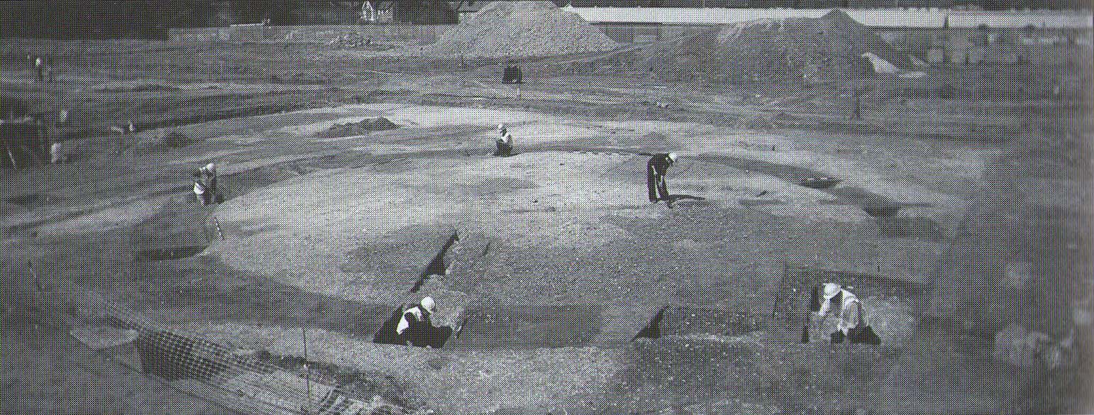
Tumulus (destroyed): OS Grid Reference – TR 389 661
Archaeology & History
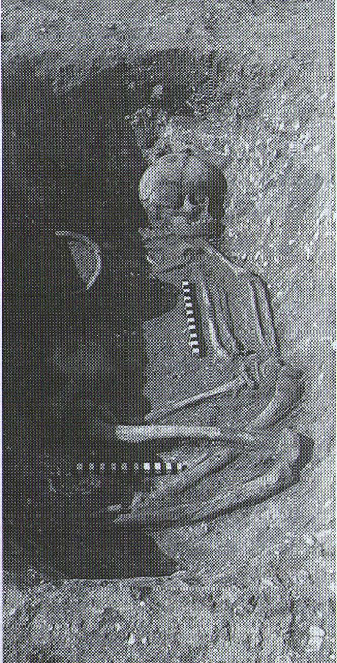
A little-known site which archaeologist Brian Philp (2002) called “a Bronze Age barrow”. When the old Greyhound Stadium at Ramsgate was being demolished for a new housing estate, planning conditions required an archaeological evaluation and so Philps and his team set out to explore the area in February 2000. They weren’t to be disappointed! Unearthing a ring ditch nearly 20 yards (18m) across, they found that it had been cut into the local chalk some three feet deep. Although there was no obvious entrance, the northeast section of the ancient monument,
“was found to be covered by a compact layer of flint metalling. This was a wide and well-made surface or platform, perhaps of Iron Age date, which clearly covered the silted ring-ditch, Nearby was a large male skeleton in a very shallow grave and with head missing due to later disturbances.”
The excavated ring ditch (after Philp 2002)
The crouched skeleton (after Philp 2002)
But the best was yet to come! In another section of the circular monument, cut into the chalk itself, they found a complete male skeleton laid in typical foetus position, on its left side, with a large beaker pot positioned in front of it. These beakers are pretty common and tend to be seen as once holding food enabling the dead to eat in their journey into the Land of the Dead. It makes sense. The entire monument has since been completely destroyed.
References:
Philp, Brian, Archaeology in the Front Line, KARU: Dover 2002.
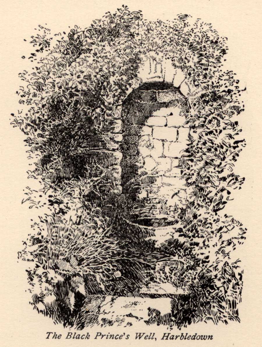
The Black Prince’s Well is found to the right of a path that curves around past the Leper Hospital / almshouses, and through the forecourt of a house.
Archaeology & History
Black Princes Well
Behind the old leper hospital, and to the west of the Church, is the Black Prince’s Well, a holy well of some renown and interest. For Canterbury pilgrims, the well was a significant watering hole before they made the last steps to that great Shrine of St. Thomas. According to Watt (1917) this was the seventh St. Thomas’s Watering at Harbledown. It still bears the alternative name of St. Thomas’s Well, a dedication unlike other sites would seem to be related to be a direct relationship, for it is recorded that he drunk from the well, accidentally leaving a shoe. Understandably, after the martyrdom, this became an important relic, and was held by the Hospital.
The spring emerges at the foot of the hill, enclosed in a six foot high semicircular domed well head made from rag stone. Most interesting a carved stone, in its central apse, depicts the Black Prince’s coat of arms, three feathers taken from the King of Bohemia at Crecy. This stone appears to havebeen possibly derived from another structure rather than being carved especially for the well head, as do the fluted stones shown in earlier photos (cf Goodsall (1968) in his Kentish Patchwork), which are now apparently missing. Either side of the well head are two courses of rag stone walling. The well is reached by a series of stone steps between two courses of stone walling. The water emerges, as a small trickle, through a five inch diameter red clay pipe, flowing to fill a circular basin.
Folklore
The well was noted as being able to cure leprous ailments, and presumably this is why the leper hospital was built in 1084 by Archbishop Lanfranc to exploit its properties. Among its many early pilgrims looking for a cure for this complaint was Edward the Black Prince, who patronised the well twice: the first on his last journey to Canterbury, when he was cured, and then finally, on his death bed in 1376. Unfortunately in this latter case the waters were obviously of no use, being unable to rid him of his syphilis, of which he died. The well subsequently named after the knight. For those unable to drink straight from the well, water was often administered to those living far from it. Evidence for this being the discovery of a leather pouch found near the well. Indeed, even the early part of this century the water was still used, especially by those from afar, for Snowdon Ward (1904) remarks that:
“the water is still in some repute for its curative powers. The sub-prior of the hospital told us that he still occasionally receives small remittances from various parts of the continent…”
Cartwright (1911) illustrates that its local reputation was still current before the Great War. He records that it was:
‘still believed by Country folks to be of great benefit to the eyes.’
Certainly the well is one of the most interesting and enchanting of Kent wells.
(taken from the forthcoming Holy Wells and Healing Springs of Kent)
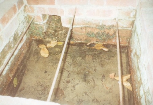
The well now lies on private land and feds a trout farm (Beckets Well Trout Farm at The Castle House, Sevenoaks Rd, Otford in Sevenoaks). To find Becket’s Well go along the A225 to the centre of Otford, park in the car park ( in front of the row of terraced shops ) near the Bishop’s Palace. Take a small private road to Castle farm, now as said, a trout farm. Inquire here, if you are able to visit the well, which lies within a complex of fish pools to the east of the farm house.
Archaeology & History
The site has been well recorded in recent centuries, for example an account of 1876, describes the site as, “endorsed within a wall, forming a chamber 15 ft across and 10 ft deep.” Both the chamber’s appearance and shape suggests that is would be ideal for immersions, of which Harper and Kershaw (1923) notes that bath and steps are defied annually by the hop pickers. It is interesting to note that Thorne (1876), with no apparent reference, gives another connection with the saint, suggesting that, “to have used by the saint as a bath.” No subsequent or previous work draws notice to this, so it is likely to be antiquarian fancy. Another more plausible possibility is that it was used by the leper hospital found on this site around 1228. They would have clearly made use of the pure water for medicinal purposes and perhaps indeed used it as a bath.
Kirkham (1948) notes it was suffering from neglect being “now said to be choked up and half full of tins.” This decline would appear to have started a long time ago, as a folly tower, now demolished, was built on Otford Mount (a nearby earthwork), from the well’s stone work. Consequently, this degraded condition prompted excavation in the 1950s by the Otford and District Historical Society; of which the following details of their findings are briefly described.
The report noted that the well consisted of two chambers, with water emerging from two arched outlets into the first of these. This chamber is surrounded on three sides by walls, thirty-five feet by thirteen feet (east end), the walls are eight feet high, and at the same level of the ground. Six steps at the south-east end give access to the well chamber. The sluice wall is five feet high, eight feet wide, and is substantially buttressed on the western front. Water runs through this sluice wall, between steep banks westward, through a lower chamber, twenty-seven feet (north sides), and thirty-five feet (west side). The water then flowed through watercress and finally through an underground, probably Tudor conduit. This conduit then passes through the site of the Palace. This stream once fed a moat, but now discharges into the Bubblestone Brook, a Darenth tributary.
Local common thought was that the well is the remains of a Roman bath house, a belief echoed by its present owner; and a view endorsed by both Ward (1932) and Harper and Kershaw (1923), who note that it “is really a Roman Bath.” This view is further supported by the two surrounding Roman villas, and hence one aim of the excavation was to evaluate this long held claim. Yet, although they showed that the well had gone through considerable renovation and rebuilding over the centuries, no remains could be positively be dated to this period. This renovation, of course, resulted in a rarity of deposits, and hence with a lack of artefacts, the subsequent interpretation was thus difficult.
The excavation was further handicapped by the waterlogged conditions. Both may have influenced the results. Consequently, there are still doubts, and the concept of a Roman origin has not been satisfactorily disproved. The earliest written record is from Otford Ministers accounts of 1440-1, indicating that by then a stone structure existed here, but how old that was again is not clear. It states:
“To a carpenter for two days to make 2 gutters to bring water from the pool of the garden to the moat and for working on and laying another gutter beyond the water course and coming from the fountain of St. Thomas to old garden, 12d; and to a carpenter for one day covering a gutter with timber and cresting it, 6d. And for two masons for 2 days for placing and laying and making a new stone wall of the fountain of St. Thomas, broken for the pipe of the water conduit, 3s, taking between them daily 12d. To five labourers 10 days digging the soil between the said fountain and moat to lay in the leaden pipe of said conduit16s 8d taking each daily 4d.”
The present floor may be ascribed to that period; although it would seem to cover an earlier lower flint floor (again possibly Roman). Between 1520-1520, Archbishop Warkham, pulled down the then existing Manor house and built the Palace, covering four acres. This consequently required a better water supply, and hence the well was improved: the original lower chamber is said to originate from this period. The full purpose of the lower chamber is not clear, but it is believed that it may have housed cisterns giving a greater flow of water. When Henry VIII acquired the Palace from Archbishop Crammer in 1537, he spent money on improvements to the estate, and probably the well. The sluice gate, strengthened by Warham, was now supported by buttresses. These may have supported a conduit house. This was recorded in 1573:
“The condiyte house or well conteyning in length XXXVI foote and in breadth XIX fote to be taken downe and newe sett upp will coste XXX pounds. The pypes conveyinge the water from hence to the offyces and small sesterns to be amended will coste Xiii.”
By the 1600s, the Palace was in disrepair and the well was only used for private consumption by Castle farm. Despite this, restoration still continued and the north, east and south wall saw upper improvements by the 1700s. In the lower chamber a stone west wall was erected on Warham’s brick foundations. By this time, the south wall was beginning to collapse and was rebuilt in the 1800s.
By 1954 repairs were again needed, as the north wall was collapsing. Goodsall (1968) reported that even after its excavation in the late 1950s, the site then enclosed in railings was forlorn and overgrown with weeds. Forty years on, the present condition is similar to that illustrated in the contemporary photo, taken during the excavation: the intervening decades have seen the inevitable degradation, through time, of its infrastructure. Fortunately, the hideous railings have been removed, obviously to erect the trout farm infrastructure, whose water is supplied by the well. The walls appear now comparably greatly overgrown, which has probably preserved them, and the sluice wall, north, south and west walls appear the most ruinous, with the walling falling away towards the sluice wall. The walling was best preserved at the east end.
The clear spring appears to flow rapidly from its source, and has the appearance of being deeper. As stated, it now has now a commercial function, providing good quality water for the raising of trout flowing through a series of fish ponds replacing the cress beds. The owner in the 1990s, a Mrs. Burrows, believed that the well was originally roofed. The results of the excavation did not indicate this although it may be a mix-up with the possibility of a conduit house over the well. She also stated the water stayed the same temperature through the winter and summer, a constant 500 C, certainly beneficial to bathers.
Folklore
One of the best known holy wells among Kent antiquarians no doubt due to the colourful legend associated with it. This tells that whilst living here in the old manor—the ruins of which called the Bishop’s Palace still stand—St. Thomas bemoaned the lack of good water. As a remedy he struck his staff into the ground and clear water gushed forth. This is a familiar folklore motif and we shall see it again referred to at other Kent sites. Perhaps it recalls the saint ordering well digging to provide fresh water and marked the position with his staff! The legends earliest reference is made by Lambard (1571):
“..stake his staffe into the drie ground ( in a place thereof now called Sainte Thomas Well) and immediately the same water appeared, which running plentifully, serveth the offices of the new house to the present day.”
The well was said to be curative, but the exact nature of its curative powers are unknown, and although belief in them was waning by 1800s, rumours of its use continued to the last world war. The Gentlemen’s Magazine of June 1820 gives the only recorded account of a cure and states that:
“an old man, who, crippled by rheumatism, was completely renovated by this bath to health and action of circumstance witnessed by the late Lord Stanhope and several of the neighbouring gentry.”
(Extracted and amended from original blog page, which includes and addition holy well – Colet’s Well –
http://insearchofholywellsandhealingsprings.wordpress.com/2012/01/12/the-holy-wells-of-otford-kent/ – and from the forthcoming Holy Wells and Healing Springs of Kent – references quoted in the piece can be found therein.)
To find Adam’s Well take the footpath from near the High Rocks Inn, leading up under the railway, continuing along the edge of a copse and into open area. Where the path turns sharp right one can see, looking ahead at this junction, a large pond and above this the black and white cottage. Beside this an arch where the spring arises. To gain access, go through the gate ahead and turn into the drive of the house called Adam’s Well and ask permission to see the well as it lives on private land.
Archaeology & History
The earliest reference to the site is found in Thomas Burr’s (1766) History of Tunbridge Wells:
“on forest a little beyond the Rocks, a spring of water was discovered, which was palled in and called Adam’s well. For what particular reason this spring was taken such notice of, it is not now very easy to determine.”
Burr (1766) perhaps implies that the well was discovered within living memory, and its fame being established before that of Tunbridge.
MacKinnon (1934) in his History of Speldhurst, perhaps drawing upon an earlier source as well as describing it in greater detail, clearly indicates it origins as a holy well, in the use of the words holy water below:
“Adam’s Well is situated in this Manor, it was famous long before the Tunbridge Wells waters were discovered, and issue from high ground at Langton. In much repute in ancient times, it is impregnated with no mineral, saline, nitrous or earthy matter, whatever, it is quite free of sediment, and was called in old times a ‘holy water.’ In 1765, the owner of this well, on digging into the rock to enlarge the pool or bath came upon an ancient stone arch, whose date could but mere matter of conjecture. This arch can be seen at the present day.”
Combined with the traces of medieval stonework, the medieval origin is supported by its name: Adam, being taken from a local fourteenth century landowner, John Adam. Fortunately, Adam’s Well still exists, much as MacKinnon (1934) describes, now enclosed in the private grounds of Adam’s Well House: a bungalow, built in the nineteenth century, after a bout of vandalism, to house a caretaker for the well. The well itself arises in a shallow, square brick-lined chamber. Enclosing this is a large stone alcove, built to allow a sheltered access to the well during inclement weather. The back wall of this shelter is of a crude nature, indicating that it may indeed be of considerable age. A stone set in its arch notes: ‘ADAMS WELL 1868.’
The waters of the Well
This date presumably refers to when the well was repaired, and the house built. In front of this is a much larger and deeper rectangular stone chamber. I was informed by the then owner in the mid-1990s, Mrs Wolf, that dogs and horses were washed within this. Over this chamber is an iron grill with the letters ‘AW’ in its centre. Mrs Wolf also told me that the quality of the water was so good that it was bottled and stored on ships for long periods. Much of the popularity of the water came from the fact that it lay along the busy old road from Peacehaven to London.
Folklore
Burr (1766) implies that its powers, to cure human ailments, were largely forgotten and:
“…at present it is only famous for the cure of mangy dogs, in which case it is esteemed an infallible remedy.”
Yet, John Britton (1836) in the Descriptive sketches of Tunbridge Wells and the Calverley estate; with brief notices of the picturesque scenery, seats, and antiquities in the vicinity describes it as being noted for:
“its transparency of its waters, and for its efficacy in some cutaneous disorders.”
Recent analysis showed that the water contains copper, which perhaps explains its lower popularity compared to Tunbridge, as copper salts were not as efficacious as iron salts. This is supported by Mrs. Wolf who noted that it had not cured her rheumatism!
Extracted from the forthcoming Holy wells and healing springs of Kent
Holy Well (destroyed): OS Grid Reference – TQ 6538 7081
Also Known as:
St. Thomas’ Well
Shingle Well
Archaeology & History
Sadly the site is gone no longer in existence it was in the roadway along the Roman Watling Street, at its junction with Church Lane, where it joins the relatively recently named Hever Road with Mailings Cross.
Local opinion, erroneously believes that its name derives from there only being one well in the district, but it originates from its substrate, being once called ‘Shinglewell’ describing the substrate. It ended its days as a traditional winch well, with a depth of 150 yards. Watt (1917) described the draw well as having a sign, reading ‘This water is not fit for drinking’— the result of contamination by a nearby stagnant pond. This wooden framework was removed during the First World War, when the well was filled in and domed over. Later, in 1935, a granite slab inscribed with: ‘Site of the Ancient Well, Singlewell Parish or Ifield’ was placed there. Unfortunately, this was removed by the County Council in 1952, and along with the combination of road improvements, the site was largely forgotten.
Folklore
Recorded in a Latin MS and translated by the Rector of Ifield between 1912-1935, the Rev K. M. Ffinch tells of a tradition in great detail, and the following is a brief resume. The legend involves a village girl called Salerna, who is said to have ‘thrown’ herself down the well after being accused of stealing some cheese. Yet, as she fell, she cried out for St. Thomas to save her from her impending doom, and upon finishing her plea, landed on some planks lying at the bottom of the well. They broke her fall, and thus saved her from her dreadful fate. She was then subsequently rescued and because of the ‘miracle’ the well was dedicated to the saint.
The incident is said to have occurred soon after St. Thomas’s martyrdom, and is said to have been one of his first miracles. The name ‘Salerna’ suggests a Roman origin, supported by its location along Watling Street, a Roman Road. Bayley (1978), using a low-land British dialect, which he believed survived until this century, states that ‘Salire Naias’ is ‘the water nymph, who springs forth and runs down’. Consequently, the story of St. Thomas miracle may have been introduced to remove the pagan tradition and refocus the beliefs of the people using a local saint.
References:
Bayley, M.,(1978) Ancient, and Holy and Healing Wells of the Thames Valley, and their Associations.
Ffinch, K.M., (1957) The History of Ifield and Singlewell
Parish, R.B., (1997) “The Curious Water-lore of Kent II: Ghosts, Fertility and Living Traditions”, in Bygone Kent, Volume 18, pp.427–32.
Watt, F., (1917) Canterbury Pilgrims and their Ways
(Extracted from the forthcoming book Holy Wells and Healing Springs of Kent)
Cairnfield (destroyed): OS Grid Reference – TQ 702 590
Archaeology & History
Ground-plan
In recent years it seems that very little has been written about this seemingly lost site, long since destroyed by the self-righteous advance of the Industrialists. It seems to have been an important place, as there were many cremated remains here in more than a dozen individual burial urns, some with flints deposited in them. The site was first described in a meeting of members of the Society of Antiquaries in 1898 by a Mr Frederick James. He talked about the site and some brief digging work around the area, thus:
“The site of the urnfield is on land belonging to Mr William Wigan, of Clare House, East Malling, and it was owing to his kind permission and active cooperation that I was enabled to visit the spot, which is on a small plateau above the River Medway, 350 yards to the southwest of New Hythe church, and between the river and the road leading from Rochester to Town Malling…
“The immediate neighbourhood…has been from time to time highly productive of archaeological remains dating from the Palaeolithic times and extended down to the Roman occupation… (But at) the Larkfield urnfield, the first indication that was afforded of the uses to which the area had been put in Romano-British times was the accidental discovery, whilst planting fruit trees, of some fragments of pottery (including portion of a Samian patera) found at the point marked A on the plan. A flat tile was found covering the fragments.”
Much more was found hereby, with the majority of the finds being “a group of urns containing cremated interments found in the urn-pits.” Although James (1898) described them as dating from the Romano-British period, from his description and illustrations it would seem that the remains here were probably of an earlier date, perhaps Iron- or even Bronze Age. But we may never know for sure.
Reference:
James, Frederick, “Discovery of a Romano-British Urnfield at Larkfield, near Maidstone,” in Proceedings of the Society of Antiquaries, 17:1, 1898.


")