St. Alkmund’s Well, Derby, Derbyshire

Holy Well:  OS Grid Reference – SK 351 371 

Geting Here

It can be found by taking North Street off Duffield Road (A6) continuing until it joins North Parade and here a little lane, called Well Street comes off and the spring is at the junction of this and Bath Street on the left hand side.

Archaeology & History

St. Alkmund's Well, Derby
St. Alkmund’s Well, Derby

First recorded in 1190 in a rental agreement but considering its association probably earlier. The well is dedicated to the Saxon saint who died 800 AD and whose tomb or shrine was located in church nearby (and is now located in the Derby Museum).  Little is recorded of its history however.

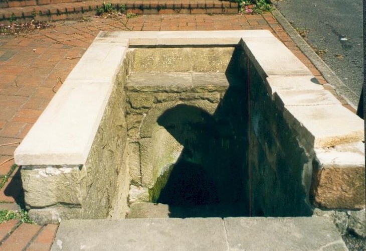
The well is below ground level with four steps to its water which flows with some force into an oval basin. A stone carving states its name. The plaque reads:

“Until the area was built up from 1814, the well was in a rural setting, part of St Helen‟s Park. The stone niche surrounding the well was built by the Rev Henry Cantrell in the early 18th century”.

It now sits rather incongruously in an area of urban landscape,  an odd juxtaposition amongst the older houses and tower blocks still exists, but is often prone to vandalism. and has suffered from it. Well dressings were discontinued due to vandalism and it was blocked off my tall metal fencing for a period recently. Now it is surrounded by a small wall and black railings which has blocked access but will protect it.

Folklore

Cox (1875–9) records that a vicar of S. Werburgh’s was cured of his low consumption, after constantly drinking its water, although the sign It has been traditionally dressed, revived in 1870 and continued infrequently until 1993, stopping because the boards were thoughtlessly vandalised. The demolishing of the St. Alkmund’s Church in the 1960s for road widening stopped the tradition of processing to the well. I was told by a local elderly lady that she still drank the water and that it was very pure…I was not sure myself!

References:

  1. Parish, R.B, (2010) Holy Wells and Healing Springs of Nottinghamshire

Copyright © Pixyled Publications


Potlock Cursus, Willington, Derbyshire

Cursus (destroyed):  OS Grid Reference – SK 314 287 to SK 321 289

Also known as:

  1. Findern Cursus
  2. Findern-Willington Cursus
  3. Potlocks Cursus
  4. Twyford Cursus

Archaeology & History

Destroyed by the usual mixture of intensive farming practices and the self-righteous advance of industrialism, this cursus of many names was discovered thanks to aerial survey photographs taken in the early 1960s.  Found only 6½ miles west of the Aston Cursus and constructed on level ground on the north side of the River Trent next to B5009 road between Twyford village and Willington.  I think the site was first described by J.K. St. Joseph (1966) in his notes on air reconnaissance finds, in which he described the site,

“So far the parallel ditches, some 220ft apart, defining the cursus have been identified on an east to west alignment across three fields for a length of some 1800ft.  This may well be only fraction of the total length of the monument, which probably extended westwards towards the new power station at Willington.  Three ring-ditches, one lying within the cursus, and two to the north, as well as a rectangular enclosure, have also been recorded.”

There was probably more to be discovered here, he thought.  And so the following year the first dig into one section of the site was made, and again in 1969.  A synopsis of this and subsequent excavation work have been reported on the PastScape website which tells:

“The cursus has been traced for a distance of at least 1560 metres, lying near the edge of the flood-plain of the Trent. Excavations in 1994-5 in advance of work on a bypass recovered Peterborough Ware sherds close to the bottom of the southern cursus ditch. Charred organic remains were also present, from which radiocarbon dates are to be sought. The excavations also uncovered a causeway between 10.5 and 19 metres in length through the northern ditch. Within this causeway were a cluster of short linear features and a post hole, all presumably evidence for controlling access into the monument. Another break in the northern ditch was shown to have been created to accommodate the course of a stream, which still runs through it. The 1994-5 excavations also confirmed that the 1969 excavations had in fact found a series of natural features which were mistakenly interpreted as representing the cursus ditches… At the south-western limit of the cursus cropmarks the southern ditch appears to have been recut and possibly reused at a later stage as a double ditched trackway…”

References:

  1. St. Joseph, J.K., “Air Reconnaissance: Recent Result, 6,” in Antiquity journal, volume 40, no.157, March 1966.
  2. Wheeler, Hazel, “The Findern Cursus,” in Derbyshire Archaeological Journal, volume 90, 1970.

© Paul Bennett, The Northern Antiquarian