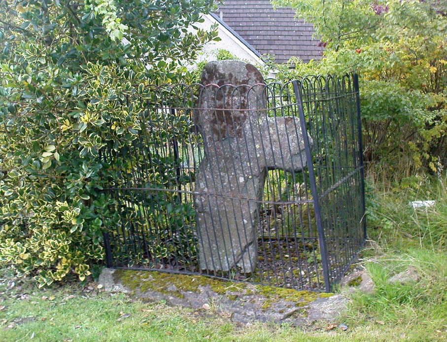
From Aberfeldy, take the B846 road over the river bridge, past Weem, a couple of miles down the valley until you see the small road on the right which leads up to the ancient hamlet of Dull. Go up and round the corner until you reach the centre of the village; and here the road turns back downhill. At this point, right by the roadside, entrapped within old railings, you’ll see the Cross of Dull.
Archaeology & History
Dull Cross behind bars
Standing more than three feet tall, the remains of this old cross with one of its extended arms broke off in previous centuries, was one of three such monuments that used to stand in the valley. This and its associates were, according to christian legend, placed as markers at an ancient centre of christian learning at Dull around the time of Adamnam (who died in Glen Lyon in 704 AD). The area was said to be an early druid college, which was later incorporated into early christian teachings. Hilary Wheater (1981) also told that in previous centuries, if anyone fell foul of the law,
“Within the boundaries of these crosses debtors, offenders or miscreants were protected from retribution. One of the crosses stands in the centre of Dull village to this day, having been used as a market cross in more recent times, and the other two, having been stolen for use as gateposts during the (19th) century, were placed in the old kirk at Weem for safety.”
References:
Stuart, John, The Sculptured Stones of Scotland, Aberdeen 1856.
Wheater, Hilary, Aberfeldy to Glenlyon, Appin Publications: Aberfeldy 1981.
Follow the same directions to get to the cup-marked stone on the slope behind Duncroisk Farm. Once here, look up the hillside and about 100 yards above you there’s the fence, and a gate in the fence. Go through that gate and walk uphill for some 20 yards where you’ll meet with a large sheet of flat sloping rock with a stream by its side. The crosses are on this rock sheet at the top left-hand side.
Archaeology & History
Although the stone here is pretty easy to find, the insignia carved on the rock itself can be troublesome to see. The accounts by both Cormack (1952) and Morris (1981) each recommend visiting the site around sunrise, but an hour before sunset is also profitable if you wanna see the design with any clarity. And of course, if you keep the rock-face wet (the adjacent stream is handy here) the carvings stand out even better!
Main section of carvingSolar cross & arrow?
It’s a quite superb carving in a truly superb setting, come rain, shine or mist — but for the cup-and-ring aficionado’s amongst you this one might not get y’ going, as we’re looking at a carving that was probably born of the more recent mythic period. Although there are between two and four faded cup-markings here, the principal designs do not echo the more usual neolithic and Bronze Age carvings scattering this part of Perthshire. Instead we find very worn examples of what have been variously called “solar wheels”, “Greek crosses”, Celtic crosses, etc. We also find simple carved ‘arrows’ at the ends of both natural and man-made lines in the rock; along with very distinct ‘eye’ or vulva symbolism. (Crawford 1957) Added to this is the possibility of human figurines discernible in the carving, very similar indeed to those found in Spain (Kuhn 1956) and elsewhere.
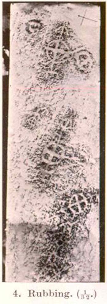
The site was first described by E.A. Cormack (1952) who wrote the following, (slightly edited) piece:
“Examination of the rough and sloping rock surface revealed an interesting group of inscribed figures, confined to an area of about 8 by 2½ feet, four of which included a cross within a circle. The figures are difficult to discern, except when thrown into relief by early morning sunlight, but are clearly demonstrated on a rubbing.
Cormack’s 1952 rubbing of the carving
“The crosses may be described in three groups:
“Group 1 — a) Near the upper edge of the rock is a cross within a circle of 8-inch diameter. The vertical axis of the cross is extended below the circle for 4 inches, resting on an ill-defined rectangular base, and upwards for 5 inches to form an arrow-head with 3-inch barbs. At the junction of the shaft of the arrow with the top of the circle is a pair of contiguous rings of about 1-inch diameter. The cross is deeply cut, to about a half-inch depth, with equal arms 4 inches long and 1 inch broad. The left arm of the cross extends beyond the circle, but this may be due to the circle being slightly excentric in relation to the cross. The lower right quadrant of the circle is marred by a natural crevice in the rock, but careful examination shows that the circle does not cut the right arm of the cross.
b) On each side of this figure is a roughly circular marking, one about 4 inches above and to the left, of 3-inch diameter, and the other 2 inches to the right, of about 5-inch diameter. In each there is an indefinite depression across the centre.
“Group 2 — a) About a foot below and to the right of Group 1 there is a boldly cut cross within a 7-inch circle. Again the vertical arm of the cross is extended above and below the circle, downwards for 5 inches to a curved arrow-head with 4-inch barbs, and upwards as an equal armed 5-inch crosslet above which is a 4-inch circle with the central axis continued through it. (The junction of this axis through the circle with the top of the small cross is slightly angled.) The main cross and circle are cut to fully half an inch in depth and one inch in breadth, but the upper part of the figure is much less distinct.
b) About 8 inches to the left of the upper part of the above figure is a very faintly incised cross within a 2½-inch circle. It is difficult to discern on the rock, but can be seen in the photograph and is very clear on the rubbing. It also appears to have an arrow-head above it.
“Group 3 — a) A foot below and to the right of Group 2 is a clearly cut cross within a 6½-inch circle. A natural cleft in the rock has been used for one axis of the cross, which lies obliquely to the others already described, and this axis terminates in an arrow-head 3 inches below the circle, and another slightly smaller arrow-head is cut 2 inches above the circle; in each case the angle formed by the arrow being towards the circle.
b) Immediately below the last cross is a curious hieroglyph not easy to make out on the rubbing, but clear in the photograph. On an 18-inch vertical axis can be seen from above downwards an arrow-head, an oblique line to the left, a faint 2-inch circle, a transverse stroke, and finally two oblique lines to the right. A natural crevice to the left of the figure rather confuses the picture.”
Ron Morris’ (1981) description wasn’t as detailed and he was initially hesitant about using the site in his rock art survey of the area, as he thought it “most likely to be early christian” in nature and period. He changed his view after talking with an associate at Bergen University, who pointed out that the symbols found here up Glen Lochay were “exactly the same as Norway’s second commonest symbol, the ‘Cross-ring’, which is contemporary with their cup-and-ring series.” Morris described the carvings here as:
“3 ‘cross-rings’ and 7 other rings, some of which have traces of crosses within them. There are also grooves, some extending from a ‘cross’-line to form an ‘arrowhead’, and one group, with ring above, rather resembles a ‘man.’ Largest ring diameter, 20cm (8in) and greatest carving depth, 1cm (½in).”
Examples of the artistic symbolism found at this ‘Duncroisk Crosses Stone’ are scattered throughout western Europe from the Bronze Age period onwards: notably at Dowth and Clonfinloch in Ireland (Brennan 1983; Coffey 1912); Jonathan’s Cave, Fife (Simpson 1867); Valcamonica, Italy (Anati 1961); and all over Norway and Sweden (Coles 2005; Gelling & Davidson 1969; Janson 1966). In more recent times we find these curious symbols etched inside the prehistoric chamber of Ty Illtud (Grinsell 1981) — but these are thought to be later additions. However, the universal nature given to such interconnecting symbols such as those found here is, simply, ritual magick. We find it across the Himalayas, Africa, north and south America – just about everywhere. It would be quite wrong to believe that the presence of an encircled ‘cross’ on this stone relates it to a christian belief system, as such a motif is found in many non- and pre-christian societies with a mythic nature akin to that of the swastika, i.e., of a world unfolding or emerging from a centre-point and the arms of the ‘cross’ outwards defining the directions and boundaries of any specified cosmology: be it landscape, heavens, spirit worlds, pregnant belly, etc.
Solar cross? Eye? Vulva?…or dancing human figure?
As Cormack (1952) described, the respective groups of carvings are integrally linked by an interconnecting line that joins the symbols in the respective groups to the other symbols. The fact that the connecting ‘lines’ are natural is meaningful in the relationship between humans and Nature; but moreover, the connecting line linking the symbols strongly implies sequential reasoning and magickal import. Indeed, these three distinct clusters (see Cormack’s rubbing) are functionally akin to magickal sigils, examples of which are found across the ancient and modern world. This is a notion that must be given serious consideration as a function in the carved stone of ‘Duncroisk 4’. Equally we can see in one section of the carving what may be a dancing human figurine, very much like rock carvings found elsewhere in Europe and beyond.
Both Erich Neumann (1973) and Alex Marshack (1972), for slightly different reasons, would also see the images carved here as early expressions of human development: either through i) the emergence of archetypal patterns and the interpretative interplay of the ego, or ii) the intellectual evolution of magickal appliance, whereby imagery and human action are recognized as meaningful in a wider natural sense. In the case of Duncroisk 4 it would more likely possess magickal import, as symbols were much more than ‘art’ and possessed meaning on several interconnecting levels, one of which being ritual function — an element that modern archaeology is slowly learning to incorporate into its analyses.
Dancing Siberian ShamanDancing shaman figure?
A more in-depth comparative essay is really needed to give a clearer exposition defining the nature of this carving… My personal view is that the carving represents, not some solar design, but one of Britain’s earliest artistic examples of human beings, in this case dancing and beating a drum or bodhran. It may indeed be the earliest pictorial example of a bodhran in the country. I’d say so. There is also the distinct possibility that the dancing figure is a shaman. We have many petroglyphs from all over the world that highlight such a character, integral to all early cultures—and this is as likely a contender as any for such a figure. (see Gough 1999; Whitley 2000, etc) It may however, be a warrior with a shield. You see the problems we can have with these damn carvings! 🙂
Folklore
This carved rock is said by local people to have been where a ‘Celtic’ saint delivered sermons to the heathen populace. The saint concerned is likely to be the one who tradition tells gave his name to the small glen immediately across the track from here: St. Charmaig. Halfway up the small glen is a small cave, barely accessible, with untouched remains of dried roots and other elements of human habitation therein. A few hundred yards to the north in old Finn’s Glen, is the forgotten Waterfall of the Oracle which sometimes isn’t even there!
References:
Anati, Emmanuel, Camonica Valley, Alfred Knopf: New York 1961.
Brennan, Martin, The Stars and the Stones: Ancient Art and Astronomy in Ireland, Thames & Hudson: London 1983.
Coffey, George, New Grange and other Incised Tumuli in Ireland, Dolphin: Poole 1977.
Coles, John, Shadows of a Northern Past: Rock Carvings of Bohuslan and Ostfold, Oxbow: Oxford 2005.
Grinsell, Leslie V., “The Later History of Ty Illtud,” in Archaeologia Cambrensis, 131, 1981.
Janson, Sverker & Westman, David, Rock-Carvings at Fiskeby, Esselte AB: Stockholm 1966.
Kuhn, Herbert, The Rock Pictures of Europe, Sidgwick & Jackson: London 1956.
Marshack, Alexander, The Roots of Civilization: The Cognitive Beginnings of Man’s First Art, Symbol and Notation, Weidenfeld & Nicolson: London 1972.
Morris, Ronald W.B., The Prehistoric Rock Art of Southern Scotland, BAR 86: Oxford 1981.Neumann, Erich, The Origins and History of Consciousness, Bollingen Princeton University Press: New York 1973.
Royal Commission on the Ancient & Historical Monuments of Scotland, Archaeological Sites and Monuments of Stirling District, Central Region, Society of Antiquaries of Scotland 1979.
Simpson, James, Archaic Sculpturings of Cups, Circles, etc., Upon Stones and Rocks in Scotland, England and other Countries, Edmonston & Douglas: Edinburgh 1867.
Whitley, D.S., The Art of the Shaman: Rock Art of California, University of Utah Press 2000.
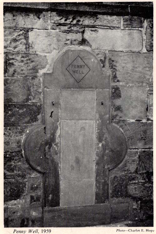
The stone marking the position of the well is situated on the north side of the road at the east end of Grange Loan, a few yards west of the junction with Findhorn Place, at Newington on the south side of Edinburgh. Unfortunately, all that now remains of the well is a red sandstone front with two pieces of metal on each side.
Archaeology & History
Set back a little into the wall alongside the road, we today see only the architectural memory of this once famous and much-reputed holy well, whose waters sadly no longer flow. Curiously omitted from the primary Scottish surveys on holy wells, it was long known as an important water source by the people of Edinburgh in ages past. The best article on the site was written by W.F. Gray (1962) some fifty years ago, in which he told:
“Built against a garden wall, the Penny Well looks rather forlorn. Now that a plentiful supply of water is in every dwelling, its public usefulness is definitely at an end, though it may slake the thirst of a passer-by. But however that may be, the Penny Well has a long if not distinguished history, though fact and fiction, it is to be feared, are inextricably linked.
“And first, as to its age. There is documentary evidence of the existence of the Penny Well as far back as 1716. In that year Sir William Johnston of Westerhall, Dumfriesshire, disposed to William Dick of Grange three acres of his lands of Sciennes, which are described as bounded on the west by the lands belonging to “said William Dick and the Penny Well.” The well really marked the south-east boundary of the lands of Grange.
“The actual age of the Penny Well is unknown. All that can be positively stated is that it has existed for at least two hundred years… How the Penny Well came by its name is another unsolved mystery. There is a story to the effect that in the earlier half of the nineteenth century an old woman who lived in the cottage opposite the well had charge of the spring and sold the water to wayfarers at a penny a glass. A very plausible story by which to account for the name! Unfortunately its credibility is shaken by the fact that…the spring was known as the Penny Well fully a century before…
“Sir Thomas Dick Lauder, when he took up residence at Grange House in 1832, was deeply interested in the well at the east end of his property. He had it restored and above it placed a tablet with the words, ‘Penny Well’ inscribed on it.
“About 1870, when feuing operations were in progress and there was much digging in the vicinity of the well, the water suddenly ceased to flow. After an interval, however, it again became copious, so much so that it formed a tiny pond in front of an adjoining house. In the hope of drawing off the water, a pit was dug. This led to an interesting discovery. Five feet below the surface, workmen came upon what there seems no reason for doubting was the original trough of the Penny Well. This “interesting and unexpected find” (to quote from The Scotsman) was covered by a large block of hard sandstone. The trough, which was circular, measured 32 inches across and had a depth of fully 1o inches in the centre.
“The Society of Antiquaries made investigations and the opinion was hazarded that “the basin into which the water ran was without doubt a baptismal font,” possibly the one which once stood beside St. Roque’s Chapel, situated at the southwest end of Grange Loan, but long since removed.
“In the (1890s) the Penny Well underwent a second restoration, the Town Council providing £30 for the purpose. By this time however, the spring was found to be impure, but the trouble was got over by substituting the town water.”
Folklore
Penny Well in 1959
Although there are no documents proving with certainty, local tradition reputed this to be one of Edinburgh’s numerous holy wells. It probably was. And whilst W. Forbes Gray seemed at a loss to explain the name of this old water source, it probably comes from the old practice of local people dropping pennies and other offerings into the well in the hope that the spirit of the waters would confer good health or other benefits upon the hopeful pilgrim. Such rites, of course, are very ancient indeed and relate specifically to the animistic spirit-nature of the site. In Mr Gray ‘s (1962) essay on the Penny Well he also had this to say:
“According to one statement, it was a holy well attached to the Convent of St. Catherine of Sienna (which stood at the foot of St. Catherine’s Place), a well whose waters were possessed of miraculous powers of healing those afflicted with blindness, in which case it would be in the same category as the well of St. Triduana at Restalrig, and the Balm Well at Liberton.”
Reputed in times gone by to be one of the never-failing springs, this clear and sparkling water supply would keep bubbling away long after all others in the area had dried-up during summer droughts.
“It is also said that the ubiquitous Mary Queen of Scots, when she visited the religious sisterhood at Sciennes, partook of the waters of the Penny Well. “
Pretty easy to find this. Go up Glen Lochay for 3 miles or so, on the road past the brilliant Stag Cottage carvings for a couple of hundred yards where you’ll see an old run-down army-looking building and past that is a curious large wooden and wire construction. Go up the farm-track next to this, past Duncroisk Farm, taking the footpath through the gates that go up to the side and behind the farm. You’ll see a rounded grassy knoll ahead of you. Head straight for it!
Archaeology & Folklore
This carving would appear to have been described for the first time by Mr Cormack (1952) in his longer essay on the cross-marked stones nearby. He said briefly:
“On the top of a small rock-strewn knoll about 300 yards behind Duncroisk farmhouse is a recumbent boulder, at one corner of which is a group of five fairly deep cup-marks of 2- to 3-inch diameter.”
Little else has been said of the site and even Ron Morris (1981) only gave the carving a brief mention in his survey, saying in passing how “east of a prominent rocky knoll, on whose summit is a cup-marked boulder…”, as he journeyed further uphill to explore the fascinating Duncroisk 4 carving with its scant cup-marks, human figurine and other curious insignia. And although this carving is probably only worthwhile for the real fanatics amongst you, I like the place — sad fella that I am!
Cup-marked stone, looking southClose-up of cups
There are five very distinct cup-marks etched onto a small, almost triangular section of the rock, sat close to a couple of other larger stones on top of the grassy knoll overlooking the glen, not far from some iron age walling. The cups are etched onto the topmost (northern) section of the rock, which is defined by a natural crack running across the surface, almost splitting one part of the stone from the other. The five cups are in no discernible linear formation. A possible sixth cup-mark and extended line may have been started on the other side of the crack on the stone, but its execution was stopped for some reason. This is by no means certain though.
Of some note is the larger stone immediately adjacent on top of this knoll, which — as Paul Hornby pointed out — is encrusted full of small garnets all over its surface. This may or may not have some significance to the cup-marked stone here. According to Mr Hornby, the nearby cup-and-ring stone at Duncroisk Burn also has garnets in it.
Morris, Ronald W.B., The Prehistoric Rock Art of Southern Scotland, BAR 86: Oxford 1981.
Royal Commission on the Ancient & Historical Monuments of Scotland, Archaeological Sites and Monuments of Stirling District, Central Region, Society of Antiquaries of Scotland 1979.
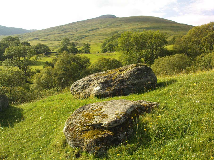
Corrycharmaig 3 stone, with Meall Dhuin Croisg rising…
Go thru Killin and, just past the Bridge of Lochay hotel, take the tiny road on your left. Go down here for 3 miles till you pass the gorgeous Stag Cottage (with its superb cup-and-rings in the field across the road) for another 300 yards, until you see Duncroisk Farmhouse set back on your right. On the other side of the road, go thru the giant deer-gates (close ’em behind you) to the river-bridge and across it. Walk along the track till you reach the turning to Corrycharmaig House on the right (over the stream), but here, go up into the field thru the gate. Walk up the hill ahead of you with its trees on the left, walking up onto the grassy level, then up again to the rounded knoll another 100 yards up. You’re here!
Archaeology & History
This is the most visually impressive of the set of four cup-marked rocks along this ridge — although if you visit here when the light is poor, or the sky’s overcast, you’ll be lucky if you can actually see much of the material. For example, I counted 38 cups on this particular stone on a day when the sky was bright, but upon checking later, found that Mr Morris (1981) described there being, “40 widely scattered cups of which, however, 29 well-defined cups are in a compact group of which 6 are in line.” Whereas more recently the Canmore website told there to be,
Corrycharmaig-3 carvingClose-up of line of cups
“At least 48 cupmarks are visible on the most westerly exposure. The cupmarks range in size from 25mm in diameter and 5mm in depth to 100mm in diameter and 40mm in depth. A straight line of six cupmarks arranged close together is orientated running from NW to SE.”
This line of six cups is very distinct and stands out as the most notable aspect on this carving, probably because it gives a sense of ‘order’ or linearity, whereas the rest of the carving (as with oh so many of them, thankfully) possess that non-linear feature of scattered cups and lines, dissolving reason and ego, and eliciting the natural meditative state, if one so cares to allow. On our most recent visit here, our eyes and fingers traced what appeared to be the faint remains of a carved line running along the bottom edge of the row of cups and then bending around the bottom cup in the same line — a little bit like the carved lines which run around the edges of the row of cups on Ilkley Moor’s Idol Stone. You can just make this ‘line’ out in the photo, below.
Cup-mark and flintClusters of cups and faint line
On one visit to the site when we’d stayed with the late great Lindsay Campbell of Stag Cottage, other sections of this carving were visible that we’d previously missed, highlighting at least 45 cup-marks that we counted. Several of the cups had been exposed by animals (sheep or deer – we couldn’t tell) cutting into the soaking wet earth and in carefully checking a couple of cups whose edges were exposed, found a small worked flint within one of the cups! I looked at it, held it, puzzled over it, then laid it back where we’d found it. You can see it in the photo here, on the right.
This carving obviously grows on you with time. And like its carved companions of Corrycharmaig (1), (2) and (4) both left and right of here, the stone rests within a natural theatre of dreams, eliciting — if only in a slight way — the non-focal perspective necessary to receive the carvings as its executor knew…
Morris, Ronald W.B., The Prehistoric Rock Art of Southern Scotland, BAR 86: Oxford 1981.
Royal Commission on the Ancient & Historical Monuments of Scotland, Archaeological Sites and Monuments of Stirling District, Central Region, Society of Antiquaries of Scotland 1979.
From Brodick, walk up the Glencloy dirt-track towards the friendly Kilmichael Hotel but turn off on the left shortly before hand, up another footpath, crossing the stream until you eventually reach the derelict house which was built into the edges of this old tomb. Upon the small rise above here, at the edge of the forestry commission trees, you’ll notice the overgrown ruins of the old tomb.
Archaeology & History
The remains here are somewhat overgrown and ramshackled, but I still like this place and in my younger days used to spend a lot of time here. It can get quite eerie in some conditions and seems to validate some of the folklore said of it. The site was described in Balfour’s (1910) magnum opus as:
“Situated in Glen Cloy, on the moor above Kilmichael House, close to a cottage called Glenrickard. There are no traces of a cairn or of a frontal semicircle. The chamber is formed of rather light flags, with their upper edges nearly on the same level, so that the monument is more like a series of cists than a chamber. The roof and end stone have gone; there are two portal stones, but the gap between them is only 7 inches. The chamber is directed N and S, with the portal to the south. There have been three compartments, but they are rather smaller than usual, the third from the portal being only 3 feet 10 inches long by 2 feet 2 inches broad. Two feet 6 inches from this compartment is another cist, which is possibly a short cist representing a secondary interment, and 10 feet farther north is a second ruined cist placed at a different angle. This last has the appearance of a short cist, but it is not carefully constructed and differs little from the component compartments of the chamber. The structure is anomalous, and may perhaps be regarded as representing a phase of degeneration in the transitional period.”
Glenrickard ground-plan (after Henshall 1972)Glenrickard on 1868 map
Audrey Henshall (1972) later descried the site in greater details in her own magnum opus and told that “two rude clay urns of the primitive flower-pot pattern (were) found in the chamber”, along with “calcined bones, said to have been in the two vessels.”
Folklore
Said by local people to be haunted, the spirit of the tomb was said to have been disturbed upon the building of the derelict house below it. Ghosts of a middle-aged couple and young child have been seen in the house; whilst the spirit of the site can generate considerable fear to those who visit the place when it is ‘awake.’ To those who may visit this out-of-the-way tomb, treat the site with the utmost respect (and DON’T come here and hang a loada bloody crystals around the place in a screwy attempt to “clean” the psychic atmosphere of the place. If you’re that sort of person, don’t even go here! The spirit of the place certainly wouldn’t want you there).
References:
Balfour, J.A., The Book of Arran: Archaeology, Arran Society: Glasgow 1910.
Henshall, Audrey Shore, The Chambered Tombs of Scotland – volume 2, Edinburgh University Press 1972.
From Dunkeld travel southeast on the A984 road to Caputh and after about 1½ miles, set back a few yards from the road amidst the trees below the Newtyle Quarries (whose mass of slate and loose rocks cover the slopes), you’ll see these two large monoliths. There’s nowhere to park here, but there’s a small road a coupla hundred yards before the stones aswell as a space to park on the verge by the side of the road a few hundred yards after them. Take your pick!
Archaeology & History
When we visited these two tall standing stones a few weeks ago, guerilla archaeologist Hornby and I were a little perplexed at the state of these stones, wondering whether they were a product of the fella’s who dug the quarries above here, or whether they were truly ancient. It seems the latter is the consensus opinion!
They were described by the great Fred Coles (1908) in one of his lengthy essays on the megaliths of Perthshire, where he thought the two stones here were all that remained of a stone circle that once stood on the flat, above the River Tay, but whose other stones “were destroyed in the making of the road” which runs right past here. Not so sure misself! He told that,
“An old cart-track runs up between the stones, leading from the main road…up to the quarry. The mean axis of the two stones runs N 13° W and S 13° E (true), and although their broader faces do not point towards the centre of a circle on the west, it is certainly much more probable that the other stones were on this side, the lower and flatter ground, than on the east, where the ground slopes and is more broken and rough.
“Both stones are of the common quartzose schist, but they differ considerably in shape. A is 6 feet 7 inches high at the north corner, but only 4 feet 10 inches at the south, and its vertical height at the east is only 3 feet. The basal girth is 13 feet 3 inches, and in the middle 15 feet 9 inches. The broad east face measures 5 feet. Stone B is level-topped and 5 feet in height; it has a basal girth of 12 feet 4 inches, and at the middle of 11 feet 8 inches. Its two broad faces are of the same breadth.”
Little else was said of the two stones for many years and, to my knowledge, no real excavation has been undertaken here. But when Alexander Thom (1990) visited the site he found that,
“This two stone alignment showed the midsummer setting sun. The south stone may possibly, by itself, have shown the setting Moon at major standstill.”
Aubrey Burl’s description of the stones was succinct and echoed much of what Coles had said decades earlier, telling:
“Two very large stones stand only 9 feet (2.7m) apart in an unusually closed-in environment for a Perthshire pair. The ground rises very steeply to the east. To the west the stones overlook the valley of the River Tay.
“Both are of local quartzoze schist and are ‘playing-card’ in shape. As usual it is the westernmost stone that is taller, 7ft 2in (2.2m) in height. Its peak tapers almost to a point. Conversely, its partner is flat-topped and only 4ft 9in (1.5m) high. The pairing of such dissimilarly shaped stones has led to the interpretation of them as male and female personifications.”
Alex Thom’s groundplanBack of the smaller stone
Burl’s latter remark thoughtfully recognises that such animistic qualities are found in many other cultures in the world and this ingredient was also an integral part of early peasant notions in Britain; therefore such ingredients are necessities to help us understand the nature and function of megalithic sites. We must be cautious however, not to fall into the increasingly flawed modern pagan notion of such male and female ‘polarizations’, nor the politically-correct sexist school of goddess ‘worship’ and impose such delusions upon our ancestors, whose worldviews had little relationship with the modern pagan goddess fallacies, beloved of modern Press, TV shows and pantomime festival displays.
Folklore
In Elizabeth Stewart’s history of Dunkeld, she narrates the tale told by an earlier historian who told that,
“these two upright stones at the Doo’s Nest, but says they are supposed to mark the graves of two Danish warriors returning from the invasion of Dunkeld.”
References:
Burl, Aubrey, From Carnac to Callanish, Yale University Press 1993.
Coles, Fred, “Report on Stone Circles Surveyed in Perthshire – Northeastern Section,” in Proceedings of the Society of Antiquaries, Scotland, volume 42, 1908.
Stewart, Elizabeth, Dunkeld – An Ancient City, Munro Press: Perth 1926.
Thom, A., Thom, A.S. & Burl, Aubrey, Stone Rows and Standing Stones – 2 volumes, BAR: Oxford 1990.
Pretty easy to find. At the eastern end of Loch Tay, go through the old village of Kenmore along the A827, towards Aberfeldy, for about a mile. At least a mile past Kenmore, keep your eyes peeled for a small left turn which takes you back into the grounds of Taymouth Castle. Go on this small road, pass the ornate walling, and you’ll see these two standing stones in front of you, before the trees, on the left. If you reach the Croftmoraig Stone Circle, you’ve gone a few hundred yards past the turning.
Archaeology & History
Fred Coles’ drawing & lay-out
These fine-looking standing stones a mile northeast of Kenmore village, on the edge of the grounds of the superb Taymouth Castle, are worthy old monoliths, encrusted by the lichens of many centuries, resting within the long grass beside the track that runs to the castle. But they have received little attention in archaeological terms. When Fred Coles (1910) described them, he thought them to be the remains of a stone circle — an impression echoed by Margaret Stewart (1966) many years later (I got the same impression aswell), but no other stones have been found to substantiate this (although Mr Gillies’ folklore remnant is intriguing). There is a notable rounded hillock immediately behind the two stones which may, or may not, have had other uprights surrounding it; though I can find no further data anywhere to substantiate such a thing.
In William Gillies’ (1938) historical survey of the area he related Mr Coles’ earlier findings of the two stones, telling us:
“There are two great standing stones just within the Principal Gate leading to Taymouth Castle. The stone A (see plan) stands at a distance of 54 feet to the NNW of B — a somewhat greater diameter than is common among the Perthshire Circles. These stones are almost equal in height — A is 4ft 9in, B is 4ft 7in — and they are both rugged blocks of a rough species of diorite. Stone A measures round the base 10ft 8in, and stone B 14ft.”
The western stoneThe eastern stone
But it seems that little else has been found about the place. It’s in a gorgeous setting (but, round here, everything’s in a gorgeous setting!) and must have related to other sites in the area, but it’s hard to contextualize the place on a single visit. If you stand behind the two stones, the shape of their ‘heads’ fits very nicely onto the rounded hillock on the northwestern skyline — which seems to have later been used as a hillfort. Whether this has any astronomical potential, I aint checked. (though Thom says nothing about them)
In geomantic terms both of these stones possess a distinct female flavour to them; the easternmost thinner of the two, particularly so. But then I could just be talking bullshit! I’d have loved to have spent more time with these two stones — bimbling, sitting, focussing, dreaming — as people of olde naturally did; but we were on the move and had other places to see. Tis a delightful spot indeed…
(NOTE – This site was first given a grid reference of NN 801 477 in Margaret Stewart’s (1967) fine essay on the standing stones at nearby Lundin; and the grid-ref has since been reproduced in texts by Burl (1993), Thom (1990) and others. Please note that this grid-ref is incorrect and is nearly a mile away from the actual position of the stones.)
Easternmost stone from another angle
Folklore
There is the possibility that this site once played a part in an important megalithic stone row. Mr Gillies (1938) once again notes an old tradition told by local people which “says that at one time there was a paved way connecting the circle, of which these stones are the remains, with the great Croftmoraig circle.” Very intriguing indeed…
References:
Burl, Aubrey, From Carnac to Callanish, Yale University Press 1993.
The sites that were once here have long since been destroyed as a result of quarrying operations. But thankfully this place was given a quick appraisal by those renowned Scottish archaeologists, Anna Ritchie and D.V. Clarke, before final destruction. They recorded the site in an early edition of Discovery & Excavation in Scotland:
“Two short cists were discovered in November, 1970, during the removal of a long low gravel ridge protruding into the flood plain of the River Clyde. The two cists were both aligned NE-SW and were 14m apart. Both employed identical construction techniques. The side slabs overlapped both end slabs and the N end slab was shorter than the other three slabs, necessitating a building-up of the floor by some 30cm. Both appear to have had a double layer of capstones although this is uncertain in one case. The cists contained and adult and child without grave goods on a gravel floor in one, and an adult with a beaker on a ‘crazy-paving’ floor in the other.”
Crazy-paving in prehistoric times sounds good! The Scots got there first!
References:
Clarke, D.V. & Ritchie, Anna, “Boatbridge Quarry: Short Cists,” in Discovery & Excavation in Scotland, 1971.
This one’s easy as it’s right by the roadside, so making it dead easy for those lazy ones amongst you who don’t like walking! You can find it just past the turn-off (signed) for Acharn Lodge, a few hundred yards along the A827 road (off the A85 by the garage) from Lix Toll, less than a mile before reaching Killin.
Archaeology & History
This solitary standing stone, not much more than about three feet tall, originally stood in the adjacent field and was moved to the edge of the road sometime ago. It was described briefly in William Gillies’ Breadalbane (1938) where he said, “Its height is 3 feet 10 inches and its girth at the base 6 feet 2 inches… This solitary stone is possibly the sole survivor of a group that once formed a circle,” though gives no more information to support this idea. It seems more likely that the stone accompanied a cairn, that was levelled by farming sometime in the 19th century.
References:
Gillies, William A., In Famed Breadalbane, Munro Press: Perth 1938.


")


