Uphall Camp, Ilford, Essex

Hillfort (destroyed):  OS Grid Reference –TQ 4383 8510

Archaeology & History

Uphall Camp, 1893

This prehistoric site was a giant – a huge colossus of an ‘enclosure’, a ‘settlement’, a ‘camp’—call-it-what-you-will.  More than a mile in circumference and with an internal area of 48 acres (big enough to hold 37 football fields!), archaeologist Pamela Greenwood (1989) told us, not only that it was “the largest recorded hillfort in Essex”, but that it compared in size with the immensity of Maiden Castle in Dorset!  Yet despite it being cited by the Oxford Archaeology report of Jonathan Millward (2016) as “the most significant archaeological site within the Borough” from the Iron Age period, it has fallen prey to the thoughtless actions of the self-righteous Industrialists who, as usual, have completely destroyed it.  It was already in a “bad” state when the Royal Commission lads visited here around 1916, saying how it was “in some danger of destruction.” Thankfully, in earlier centuries, we did have more civilized and educated people who seemed proud to describe what there was of their local history.

Early literary accounts seem sparse; although in Mr Wright’s (1831) huge commentary to Philip Morant’s (1768) Antiquities of Essex, he thought that the adjoining parish of Barking—whose ancient boundary line is marked here by the southern embankments of the enclosure—derived from the Saxon words burgh-ing, which he transcribed as ‘the fortress in the meadow’.  The same derivation was propounded in Richard Gough’s 1789 edition of Camden’s Britannia, from the “Fortification in the meadows.”  It seems a more reasonable derivation than that ascribed in the Oxford Names Companion (2002) as the “(settlement of) the family or followers of a man called *Berica” (the asterisk here denotes the fact that no personal name of this form has ever been found and is pure guesswork).  But according to the English Place-Name Society text on Essex by Paul Reaney (1935), the early spellings of Barking implies a derivation from ‘birch trees.’  Anyway….

Uphall Camp c.1735

A fine plan of the site was drawn by John Noble some time around 1735 although, curiously, he seems to have written no notes about the place.  The first real citation of Uphall Camp as an antiquity seems to have been by Morant himself (1768).  In a work bedevilled by genealogical and ecclesiological tedium, he occasionally breaks from that boredom to tell of the landscape and the people living here, mentioning our more ancient monuments—but only in passing, as illustrated here:

“Near the road leading from Ilford to Berking, on the north west side of the brook which runs across it, are the Remains of an ancient Entrenchment: one side of which is parallel with the lane that goes to a farm called Uphall; a second side is parallel with the Rodon, and lies near it; the third side looks towards the Thames; the side which runs parallel with the road itself has been almost destroyed by cultivation, though evident traces of it are still discernible.”

Just over thirty years later we were thankfully given a more expansive literary portrayal by Daniel Lysons. (1796)  Lysons was drawing some of his material from a manuscript on the history of Barking by a Mr Smart Lethieullier, written about 1750 (this manuscript was unfortunately destroyed by fire, and no copies of it ever made).  He told us:

“In the fields adjoining to a farm called Uphall, about a quarter of a mile to the north of Barking-town, is a very remarkable ancient entrenchment: its form is not regular, but tending to a square; the circumference is 1792 yards, (i.e., one mile and 32 yards,) inclosing an area of forty-eight acres, one rood, and thirty-four perches.  On the north, east, and south sides it is single trenched: on the north and east sides the ground is dry and level (being arable land), and the trench from frequent ploughing almost filled up: on the south side is a deep morass: on the west side, which runs parallel with the river Roding, and at a short distance from it, is a double trench and bank: at the north west corner was an outlet to a very fine spring of water, which was guarded by an inner work, and a high keep or mound of earth.  Mr. Lethieullier thinks that this entrenchment was too large for a camp: his opinion therefore is, that it was the site of a Roman town.  He confesses that no traces of buildings have been found on that spot, which he accounts for on the supposition that the materials were used for building Barking Abbey, and for repairing it after it was burnt by the Danes.  As a confirmation of this opinion, he relates, that upon viewing the ruins of the Abbey-church in 1750, he found the foundations of one of the great pillars composed in part of Roman bricks. A coin of Magnentius was found also among the ruins.”

But this is a spurious allusion; albeit an understandable one when one recognizes that the paradigm amongst many writers at the time was to say that anything large and impressive was either a construction of the Romans or the Danes, as the early British—it was deemed—were incapable of building such huge monuments.  How wrong they were!

In Mrs Ogborne’s (1814) description of Uphall Camp, she thought that its form and character betrayed anything Roman and—although she wasn’t specific—seemed to prefer the idea that our earliest Britons had built this place.  And she was right!  She wrote:

“There is, about a quarter of a mile from Barking, adjoining Uphal farm, on the road to Ilford, an antient entrenchment, a mile and 32 yards in circumference, with the corners rounded off; the west side, parallel with the river Rodon, has a double trench and bank, and a high keep, or mound of earth, about 94 yards round the base, about nine in height, on the side of the river, and seven on the opposite side: there was an outlet to a spring of water at the north-west corner; the south side has a morass; the north and east sides are single trenched, which is almost lost by cultivation, and in some places barely discernible.”
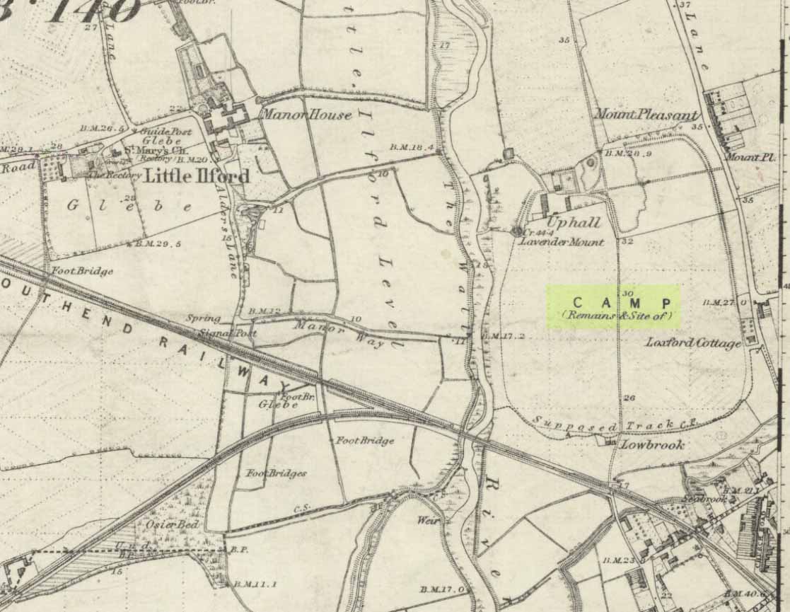
Uphall Camp on 1873 map
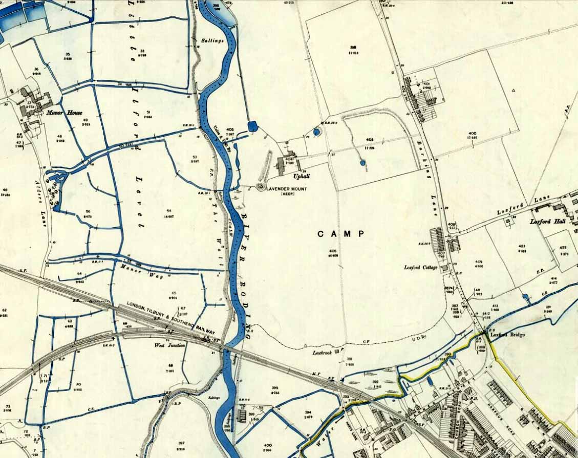
Uphall Camp on 1897 map

When the Ordnance Survey lads gave the site their attention in the 1870s, they showed its real size for the first time—cartographically at least!  As the two old maps either side here show, it was a big one!  Although some sections of the edges of the ‘camp’ were diminishing at the time, much of it was still in evidence.  And when the local writer Edward Tuck (1899) wrote about it, he told us,

“On the north and east sides the ground is dry and level (being arable land) and the trench from frequent ploughings is almost filled up. On the south side is a deep morass; on the west side which runs parallel with the river Roding, and at a short distance from it is a double trench and bank; at the north-west corner is an outlet to a very fine spring of water, which is guarded by an inner work and a high keep or mound of earth designated “Lavender Mound.”  Mrs. Ogborne in her History of Essex gives a charming drawing of this mound as it was in 1814, and says that the mound was then about 94 yards round the base, and about nine yards in height, with trees growing upon it, and its surface covered with soft verdure.”
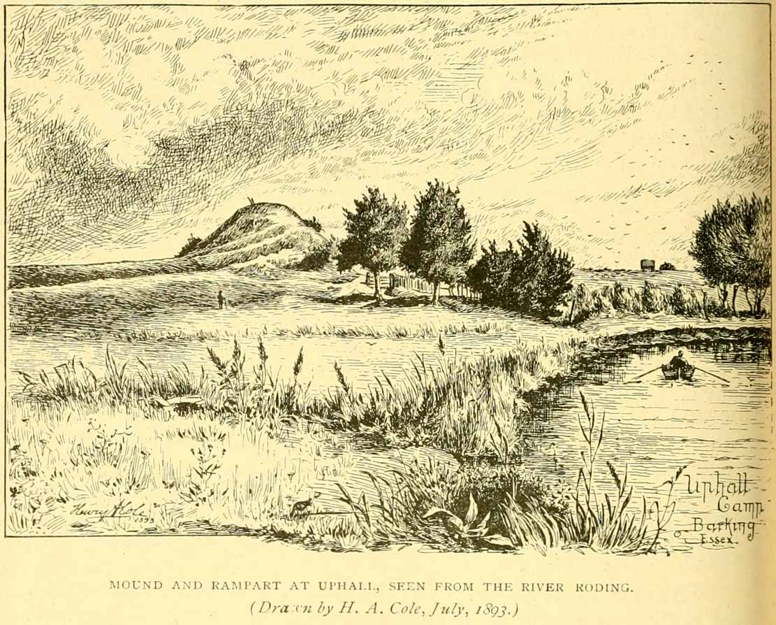
Uphall earthworks in 1893

Several other writers mentioned the remaining embankments of Uphall Camp, which was beginning to fade fast as the city-builders spread themselves further afield.  A chemical factory did most of the damage (as they still do, in more ways than one!).  When the Royal Commission (1921) lads came here they curiously deemed it as an “unclassified” structure; but in those days unless things were Roman in this neck of the woods, it could unduly puzzle them!  Their account of it told that,

“the remaining earthworks consist of a short length of rampart with an irregularly shaped mound at the north end, which is known locally as Lavender Mount, and another short length north of the farmhouse; there are also traces of the east side of the camp running parallel with Barking Lane.  An early plan shows part of the north and east sides of the earthwork and suggests that it was roughly rectangular in outline.  In 1750 the north, east and south sides are said to have had a single trench, and the west side a double trench and bank.

“The mound is 21 ft. high and 85 ft. in diameter at the base. The date of the earthwork is doubtful, but it does not appear to be pre-Roman.”

1908 photo of Lavender Mount

1814 sketch of Lavender Mount

The ‘Lavender Mount’ aspect in this monument, seemed a peculiar oddity.  Even modern archaeologists aren’t sure of what it might have been, erring on the side of caution with interpretations saying it was a keep of some sort, or a small beacon hill.  It might have been of course; but if it was a beacon hill, there would very likely be some written account of it – but none exist as far as I’m aware.  Initial impressions when just looking at the images is that it was a tumulus, but the position of the mound on top of the raised earthen embankments tells us that it was constructed after the Iron Age ramparts.  Writers of the Victoria County History (1903) said the same, suggesting a Saxon or more likely Danish origin.  The area around Lavender Hill was eventually explored by archaeologists in 1960, and several times thereafter – and what they uncovered showed us a continuity of usage that spanned several thousand years!

The 1960 excavation took place where, adjacent to the embankment, “the bank and ditch contained middle-Iron Age pottery”, along with traces of the large wooden fencing-posts (palisade) that initially surrounded and protected the enclosure. In Pamela Greenwood’s (1989) archaeological report, she told us that in further digs in 1983-4 there were discoveries of neolithic and Bronze Age flint remains.  The finds included,

“a leaf-shaped arrowhead and a discoidal scraper… fragments of an Ardleigh type urn, probably from a middle Bronze Age burial disturbed by later activity.  An L-shaped ditch, possibly part of an enclosure or field boundary, was found during the watching-brief. It contained flint-gritted pottery, perhaps attributable to the Bronze Age.”

But the majority of the finds at Uphall came from the mid-Iron Age period.  Greenwood continued:

“The settlement, judging from the relatively small area of the fortification actually excavated, was laid out in a regular way.  As might be expected, the round-houses appear to be aligned, indicating some sort of street-pattern.  ‘Four-poster’ structures have been located in particular areas, again pointing to some sort of designation of special zones of activity. Large quantities of charred grain from the post-pits and surroundings would confirm that these structures are granaries….

“The middle Iron Age structures are of several types: round-houses or round-buildings, pennanular enclosures, (wooden) ‘four-posters’; rectangular structures, ditches, post-holes and innumerable and ill-assorted small pits, small gullies and holes dug into the gravel.  Many of the last three types are undatable and could belong to the Iron Age, Roman, medieval or later activity on the site.”

I could just copy and paste the rest of Greenwood’s report here, but it’s quite extensive and interested readers should refer to her own account in the London Archaeologist .  It’s a pity that it’s been destroyed.

References:

  1. Crouch, Walter, “Ancient Entrenchments at Uphall, near Barking, Essex,” in Essex Naturalist, volume 7, 1887.
  2. Crouch, Walter, “Uphall Camp,” in Transactions of the Essex Archaeological Society, volume 9 (New Series), 1906.
  3. Doubleday, H.A. & Page, William (eds.), Victoria History of the County of Essex – volume 1, Archibald Constable: Westminster 1903.
  4. Greenwood, Pamela, “Uphall Camp,” in Essex Archaeology & History News, 1987.
  5. Greenwood, Pamela, “Uphall Camp, Ilford, Essex,” in London Archaeologist, volume 6, 1989.
  6. Hanks, Patrick, et al, The Oxford Names Companion, Oxford University Press 2002.
  7. Hogg, A.H.A., British Hill-Forts: An Index, BAR: Oxford 1979.
  8. Kemble, James, Prehistoric and Roman Essex, History Press: Stroud 2009.
  9. Lysons, Daniel, The Environs of London – volume 4, T. Cadell: London 1796.
  10. Millward, Jonathan, London Borough of Redbridge: Archaeological Priority Areas Appraisal, Oxford Archaeology 2016.
  11. Morant, Philip, The History and Antiquities of Essex – volume 1, T.Osborne: London 1768.
  12. Norris, F.J., “Uphall Camp”, in Gentleman’s Magazine, 1888.
  13. Ogborne, Elizabeth, The History of Essex, Longmans: London 1814.
  14. Reaney, Paul, The Place-Names of Essex, Cambridge University Press 1935.
  15. Royal Commission Ancient & Historical Monuments, England, An Inventory of the Historical Monuments in Essex – volume 2, HMSO: London 1921.
  16. Tuck, Edward, A Sketch of Ancient Barking, Its Abbey, and Ilford, Wilson & Whitworth: Barking 1899.
  17. Wilkinson, P.M., “Uphall Camp,” in Essex Archaeology & History, volume 10, 1979.
  18. Wright, Thomas & Bartlett, W., The History and Topography of the County of Essex – volume 2, G. Virtue: London 1831.

© Paul BennettThe Northern Antiquarian


Broad Oak, Hatfield Broad Oak, Essex

Legendary Tree:  OS Grid Reference – TL 5352 2083

Also Known as:

  1. Doodle Oak

Archaeology & History

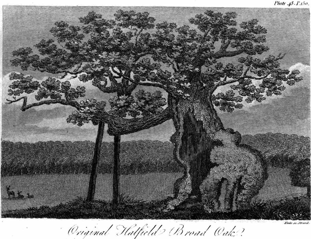
Hatfield’s Doodle Oak, 1807

Erroneously ascribed by the reverend Winsland (1952) as being the ‘Doodle Oak’, the ancient and giant tree called the Broad Oak was, as records show, always known by this name, but was subsequently replaced by another after its demise.  It was this second tree that became known as the Doodle Oak.  Winsland described it as “an immense and famous oak tree”, under whose “spreading branches in olden days the Lord of the Manor probably held his court and dispensed justice.”

The tree was described as early as 1136 AD and was probably an early tribal meeting site, or moot spot.  In Philip Morant’s (1763) work, he described it as,

“A tree of extraordinary bigness. There has been another since…called Doodle Oak.”

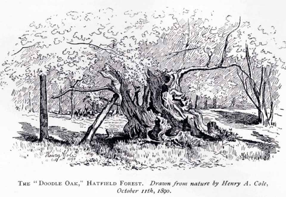
The old Oak in 1890

The Doodle Oak was thought to date from around 10-11th century and its predecessor may have been upwards of a thousand years old before this one took its place.  In 1949, one patient botanist, Maynard Greville, investigated the Doodle Oak tree-rings and found it to be 850 years old.  Other estimates suggest it was a hundred years older than that!  Whichever was the correct one, a measurement of its trunk found it to be some 19 yards in circumference – one of the largest trees ever recorded in Britain!

Sketches of its dying body were thankfully made near the beginning and the end of the 19th century: one in Mr Vancouver’s (1807) Agriculture of Essex, and the other by Henry Cole of the Essex Naturalist journal.

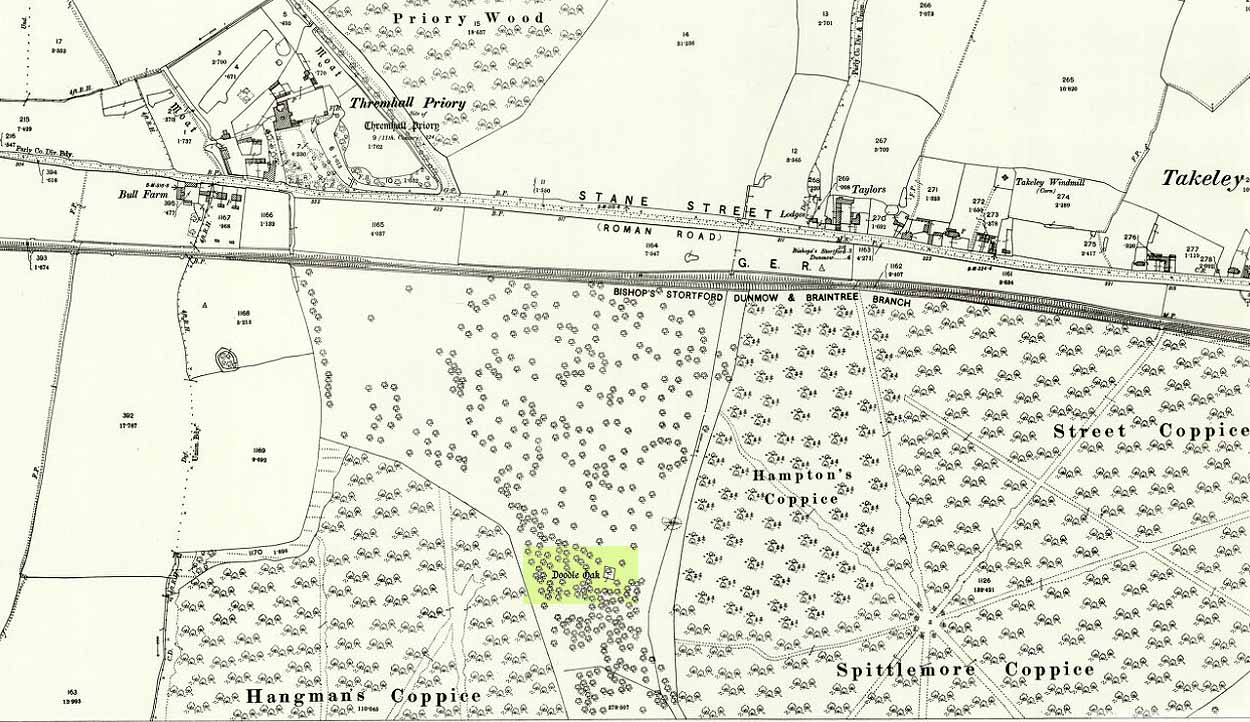
Doodle Oak on 1896 map

Some speculate that the Broad Oak of ancient times and the subsequent Doodle Oak were at very different places in the parish, but without hard evidence this idea is  purely hypothetical.  And whilst the name ‘broad’ oak is easily explained, the name ‘doodle’ is slightly more troublesome.  However, a seemingly likely etymology is found in the Essex dialect word dool, which Edward Gepp (1920) told,

“seems to mean, (1) a landmark; (2) a path between plots in a common field.”

The former of the two would seem to be the most likely.  This is echoed to a greater degree in Wright’s (1900) magnum opus, where he found the dialect word dool all over the southeast, meaning,

“a boundary mark in an unenclosed field.”

Giant trees on ancient boundaries, like the Broad Oak of earlier times, would seem to be the most probable reason for its name.  Today, all that’s left of the site is a small plaque on a small tree-stump, telling us what once stood here…

References:

  1. Gepp, Edward, Contributions to an Essex Dialect Dictionary, George Routledge: London 1920.
  2. Morant, Philip, The History and Antiquities of the County of Essex – volume 2, 1763.
  3. Reaney, P.H., The Place-Names of Essex, Cambridge University Press 1935.
  4. Vancouver, Charles, General View of the Agriculture of the County of Essex – volume 2, Richard Phillips: Blackfriars 1807.
  5. Winsland, Charles, The Church of Saint Mary the Virgin, Hatfield Broad Oak, Anchor: Bishop Stortford 1952.
  6. Wright, Thomas, English Dialect Dictionary – volume 2, Henry Frowde: London 1900.

© Paul BennettThe Northern Antiquarian


Bedford Hill, Tooting, Surrey

Tumulus (destroyed):  OS Grid Reference – TQ 288 726

Archaeology & History

This long lost prehistoric tomb is one of many that has fallen under the destructive hammer of the christian Industrialists in this part of the country.  Located somewhere in the parkland grounds of Bedfordhill House (also destroyed), its memory was thankfully preserved by the renowned folklorist and historian Walter Johnson (1903) who wrote of it in his work on prehistoric Surrey, where he told:

“A few years ago a supposed barrow was levelled in Bedford Park, Bedford Hill, Tooting, and no record taken of the results. The mound was enclosed in the Park for several  centuries, but when the grounds were laid out for building purposes ten or a dozen years since, it suffered rough usage, and was finally destroyed. It was nearly 100 yards long, and about 20 feet in breadth in its highest part.  It ran East and West, and had several trees growing on it before its desecration….  A moat had been made round the mound for about two-thirds of its circuit.  This moat was supplied with water by the Ritherdon, a small stream rising in Streatham.  The name is preserved in the adjacent Ritherdon Road.  The material of the mound was gravel and gravelly loam, which, in the neighbourhood, occurred only in a thin layer, thus forbidding the conclusion that the structure was merely composed of the soil dug out in making the moat. The excavated material would largely be London Clay.  As the genuineness of this barrow was, we believe, called in question after its demolition, when the subject was beyond reconsideration, we mention two shreds of collateral evidence. The ground on which the tumulus stood was about the highest in the district. The name Tooting may also have some bearing, for Mr. Clinch thinks that it was a Celtic settlement where was worshipped the deity known as Taith. (Compare also toot-hill, as exemplified in Tot Hill, Headley, Tothill Fields, Westminster, famous for fairs and tournaments, also Tutt Hill, near Thetford.)”

The ‘toot’ in Toothill however, is ascribed by Gover, Mawer & Stenton (1934) as being the usual “look-out hill”.  Although they do make note of the fact “that there is no hill in Tooting which would make a good look-out place.”  But if this was a large barrow of some type, it would explain the etymological oddity.  Any further information on this site would be welcome.

References:

  1. Gover, J.E.B., Mawer, A. & Stenton, F.M., The Place-Names of Surrey, Cambridge Univserity Press 1934.
  2. Johnson, Walter, Neolithic Man in North-East Surrey, Elliot Stock: London 1903.
  3. Smith, A.H., English Place-Name Elements – volume 2, Cambridge University Press 1954.

© Paul BennettThe Northern Antiquarian


Tumble Beacon, Banstead, Surrey

Tumulus:  OS Grid Reference – TQ 2432 5902

Archaeology & History

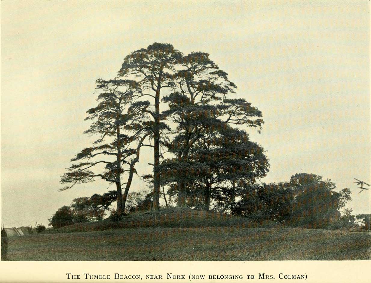
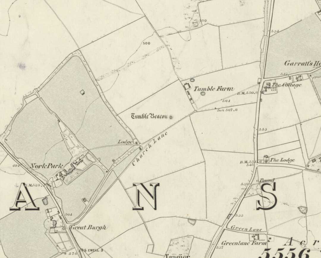
Tumble Beacon in 1911

This ancient “bowl barrow” as the modern archaeo’s are wont to describe it, is a Bronze Age tumulus that has seen better days.  But at least it’s still there – albeit slightly damaged and enclosed by modern housing, in the back of someone’s garden.  I expect that if you were to ask the owners, it would be OK to see this 4000 year old burial mound (in Scotland at least, we always find people very amiable when it comes to asking such things).  It’s quite a big thing too, so you can’t really miss it!  Standing more than 12 feet high, it rises like an archetypal fairy mound—now out of place—measuring some 38 yards east-west and roughly 44 yards north-south.

Highlighted on the early OS-map of the region, the name of the site indicates its multi-period usage, with the ‘beacon’ element derived  from when, in 1594, a fire was lit upon it to tell of the arrival of the Spanish Armada.  Whether it had been used as a beacon prior to that, I can find no historical accounts.  One of the early archaeological descriptions came from the pen of the old historian and folklorist, Walter Johnson (1903), who told us simply:

Tumble Beacon on 1871 map
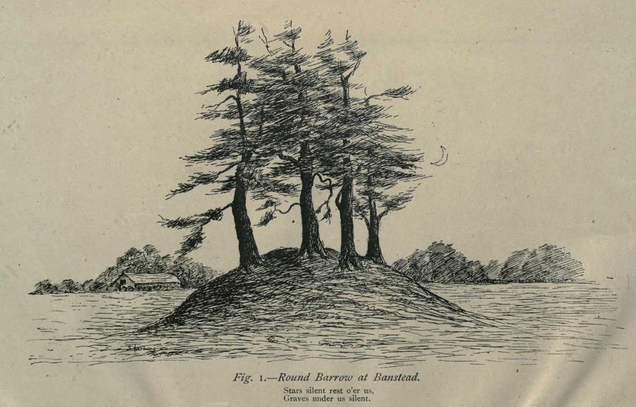
Walter Johnson’s 1903 sketch

“About a mile South-west of Banstead Church, in a field close by Tumble Farm, on the outskirts of Nork Park, is an eminence marked on the map as Tumble Beacon.  A picturesque clump of pines stands on the mound, which, from its general character, and from the flint scraps we have found there, we have every reason to believe is a round barrow, despite the local tradition that it is a ‘sea-mark.’  The Scotch pines, in such positions as we find here, may probably, Mr. Grant Allen thought, be the descendants of trees put in by human hands when the barrow was first raised.”

Whilst this latter idea might be very hard to prove, the assertion that it’s prehistoric certainly gained favour as more antiquarians examined the site.  Johnson later told that when examining this and other sites nearby (sadly destroyed) he came across a variety of prehistoric stone utensils in the area.

References:

  1. Gover, J.E.B., Mawer, A. & Stenton, F.M., The Place-Names of Surrey, Cambridge Univserity Press 1934.
  2. Grinsell, Leslie V., The Ancient Burial Mounds of England, Methuen: London 1936.
  3. Johnson, Walter, Neolithic Man in North-East Surrey, Elliot Stock: London 1903.
  4. Lambert, H.C.M., History of Banstead in Surrey, Oxford University Press 1912.

© Paul BennettThe Northern Antiquarian


Holy Well, Barking, Essex

Holy Well (destroyed):  OS Grid Reference – TQ 4421 8484

Archaeology & History

Barely 200 yards to the immediate southeastern edge of the once gigantic hillfort of Uphall Camp, could once be found an old holy well, last recorded it would seem in 1456.  The site was located just yards to the south of the old boundary that separates the parishes of Ilford and Dagenham.  Its location was described in the Victoria County History:

“A mile south of Ilford Bridge the Roding is joined by Loxford Water, a stream rising near Hog Hill, in Dagenham, and known in its upper reaches as Seven Kings Water. In 1456 the lower part of the stream was called Halywellbrooke.”

We also have an account in the Barking Abbey Rental, which told us there was “land in Longland at Halywellbrooke”, as well as “pasture lying at the northern head of Luzias land…near Halywell and…at Loxfordbrigge.” (Harte 2008)  It has long since been destroyed.

References:

  1. Harte, Jeremy, English Holy Wells – volume 2, Heart of Albion Press: Marlborough 2008.
  2. Powell, W.R. (ed.), A Victoria County History of Essex – volume 5, OUP: London 1966.

LinksHoly Well, Barking on The Megalithic Portal


Boskenna Cross, St Buryan, Cornwall

Wayside Cross:  OS Grid Reference – SW 42579 24266

Also Known as:

  1. Historic England Grade II Listed Building No. 1007955

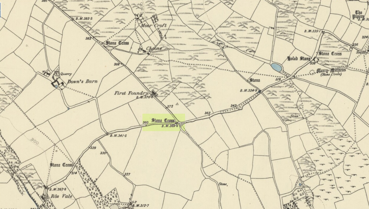
Boskenna Cross on 1887 map

Getting Here

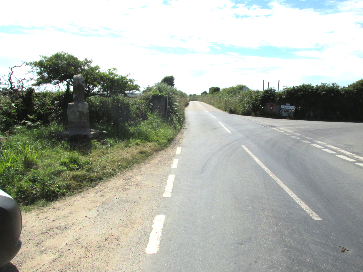
Travelling along the B3315 from Penzance to Lands End, the Cross is on the south side of the road at the junction with the minor road to St Buryan, past the Merry Maidens stone circle.

Archaeology & History

Arthur Langdon (1896), in his magnum opus on Cornish Crosses, describes this wheel-headed wayside cross:

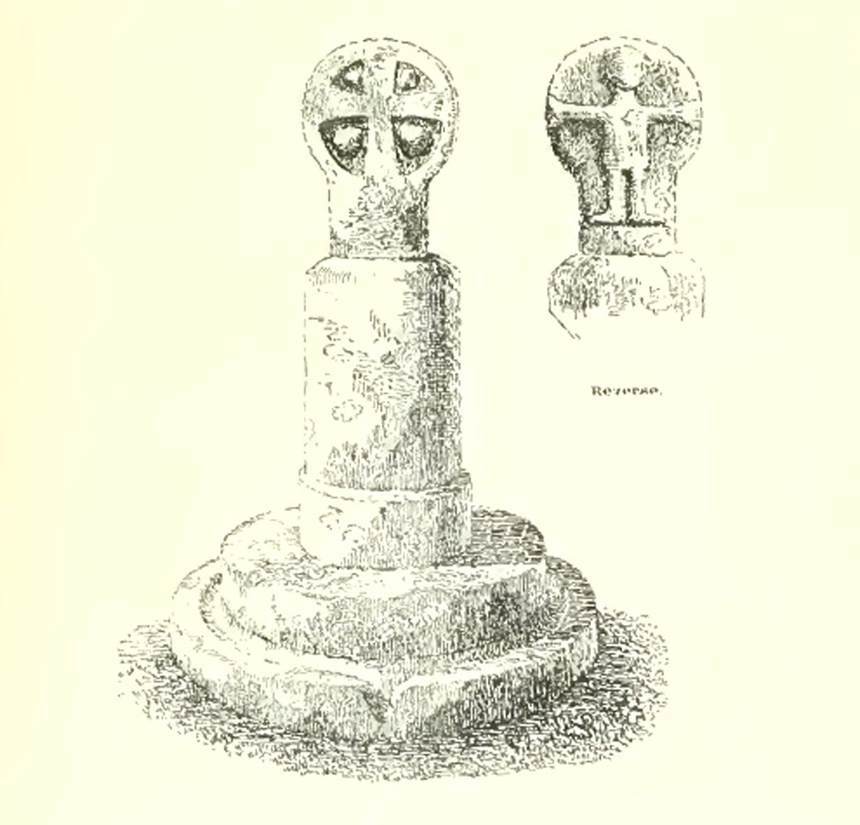
Sketch from Langdon’s 1896 book

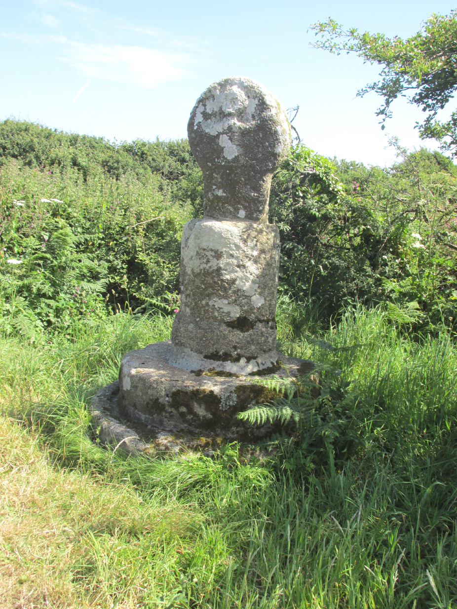
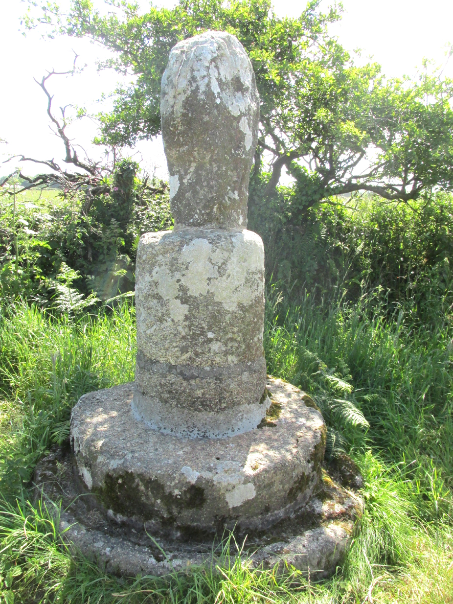
The only ancient part of the monument is the little cross at the top, which is mounted on a base made up of an extraordinary collection of apparently disused circular granite stones. Immediately beneath the cross is a cylindrical piece, the upper edge of which is roughly rounded off. Beneath this comes a short drum, about two inches wider than the piece above and nine inches deep. The next two stones are much wider but not so deep as the last, the bottom one consisting of the lower portion of an old cider-press, with its surrounding channel and lip !

Its roadside position.

There is a good deal to admire in the feeling which prompted this effort to once and for all preserve so ancient a relic, and the care bestowed in the erection of this curious substructure goes far to remove its incongruity.

Front — The figure of our Lord here sculptured is quite the best example in which He is represented wearing the tunic; the expanded sleeves are especially apparent, as well as the outline of the garment above the knees. The feet are very large, and turn outwards at right angles.

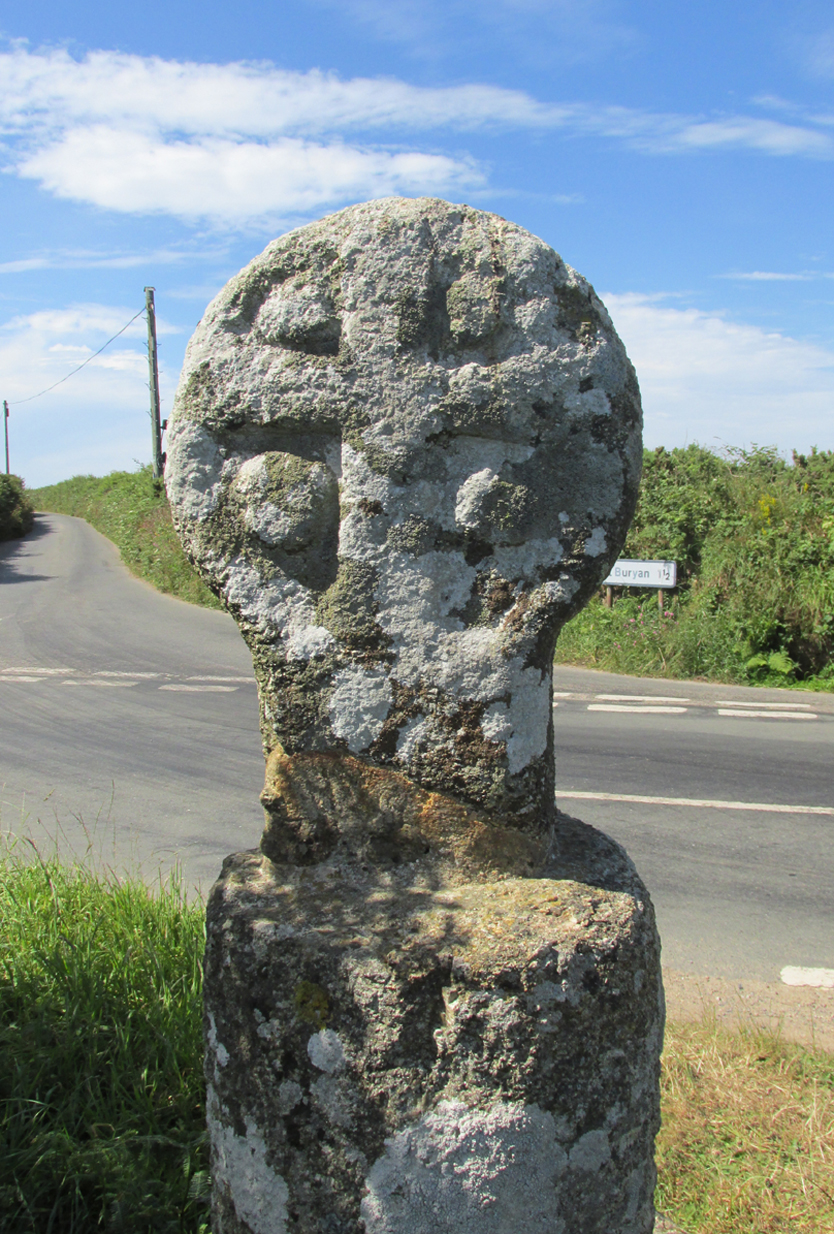
The Crucifixion face

Back — On the head is a cross with expanded limbs, flush with the surface of the stone. The four triangular sinkings, or recesses, which form the background are not of uniform size, the lower being considerably larger than those above, thus making the lower limb the longest. The inner portion of each sinking is raised, forming bosses in low relief.

Dimensions — Total height of the monument, 6 ft. 10 in; height of the cross, 2 ft. 4 in; width of head, 1 ft. 8 in; width of shaft, 12½ in.

The cross has had a chequered history. It is not known when it was demolished.  Langdon, once more, takes up the story:

The opposite face.

Mr. J. H. Johns, landlord of the “King’s Arms”, St. Buryan, informed me of the circumstances connected with the discovery of this cross. It appears that formerly one of the angles at the intersection of these roads was so sharp and awkward for traffic that, in 1869, the local authorities decided to ease this corner by rounding off the hedge, which was then about ten feet thick. Mr. Johns’ father was one of the men employed on this work, and shortly after commencing he found the cross buried in the hedge. By the advice of His Honour Charles Dacres Bevan, County Court Judge of Cornwall, and then residing at Boskenna Mansion House, the cross was erected on the triangular piece of grass in the middle of the roads, a spot on which it is extremely likely it originally stood.

Side view from the east.

In 1941 and 1942, the Cross was demolished by road vehicles, whereupon the council removed it to its present roadside position. It was again hit by a vehicle in 1992. And in 2002 there was another incident, reported by Meyn Mamvro:

..In February the top of the cross was found lying by the roadside. It is not known whether this was the result of deliberate vandalism or a road traffic accident, but local village witch Cassandra Latham acted quickly in alerting Cornwall Archaeological Unit, who took it away for repair and restoration…

References:

  1. Langdon, Arthur G., Old Cornish Crosses, Truro, Joseph Pollard, 1896.
  2. Langdon, Andrew, Stone Crosses in West Penwith, The Federation of Old Cornwall Societies, 1997.
  3. Meyn Mamvro, No 49, Autumn 2002, p. 4

© Paul T. Hornby 2018


St. Bride’s Well, London, Middlesex

Holy Well (covered):  OS Grid Reference – TQ 3157 8111

Archaeology & History

St Brides Well on 1896 map

Close to the centre of that corporate money-laundering place of homo-profanus that is the City of London, was once a site that represents the antithesis of what it has become.  Tacked onto the southeastern side of St. Bride’s church along the appropriately-named Bride Lane, the historian Michael Harrison (1971) thought the Holy Well here had Roman origins.  It “was almost certainly,” he thought,

“in Roman times, the horrea Braduales, named after the man who probably ordered their construction: Marcus Appius Bradua, Legate of Britain under Hadrian, and the British Governer in whose term of office the total walling of London was, in all likelihood, begun.”

This ‘Roman marketplace of Bradua’ that Harrison describes isn’t the general idea of the place though.  Prior to the church being built, in the times of King John and Henry III, the sovereigns of England were lodged at the Bridewell Palace, as it was known.  Mentioned in John Stow’s (1720) Survey of London, he told:

“This house of St. Bride’s of later time, being left, and not used by the Kings, fell to ruin… and only a fayre well remained here.”

The palace was eventually usurped by the building of St. Bride’s church.  The most detailed account we have of St. Bride’s Well is Alfred Foord’s (1910) magnum opus on London’s water supplies.  He told:

“The well was near the church dedicated to St. Bridget (of which Bride is a corruption; a Scottish or Irish saint who flourished in the 6th century), and was one of the holy wells or springs so numerous in London, the waters of which were supposed to possess peculiar virtues if taken at particular times.  Whether the Well of St. Bride was so called after the church, or whether, being already there, it gave its name to it, is uncertain, more especially as the date of the erection of the first church of St. Bride is not known and no mention of it has been discovered prior to the year 1222.  The position of the ancient well is said to have been identical with that of the pump in a niche in the eastern wall of the churchyard overhanging Bride Lane.  William Hone, in his Every-Day Book for 1831, thus relates how the well became exhausted: ‘The last public use of the water of St. Bride’s well drained it so much that the inhabitants of the parish could not get their usual supply.  This exhaustion was caused by a sudden demand on the occasion of King George IV being crowned at Westminster in July 1821.  Mr Walker, of the hotel No.10 Bridge Street, Blackfriars, engaged a number of men in filling thousands of bottles with the sanctified fluid from the cast-iron pump over St. Bride’s Well, in Bride Lane.”  Beyond this there is little else to tell about the well itself, but the spot is hallowed by the poet Milton, who, as his nephew, Edward Philips records, lodged in the churchyard on his return from Italy, about August 1640, “at the house of one Russel a taylor.”

In Mr Sunderland’s (1915) survey, he reported that “the spring had a sweet flavour.”

Sadly the waters here have long since been covered over.  A pity… We know how allergic the city-minds of officials in London are to Nature (especially fresh water springs), but it would be good if they could restore this sacred water site and bring it back to life.

Folklore

Bride or Brigit has her origins in early British myth and legend, primarily from Scotland and Ireland.  Her saint’s day is February 1, or the heathen Imbolc (also known as Candlemas).  Although in christian lore St. Bride was born around 450 AD in Ireland and her father a Prince of Ulster, legend tells that her step-father (more probably a teacher) was a druid and her ‘saintly’ abilities as they were later described are simply attributes from this shamanic pantheon. Legends—christian and otherwise—describe Her as the friend of animals; possessor of a magickal cloak; a magickian and a healer; and whose ‘spirit’ or genius loci became attached to ‘sacred sites’ in the natural world, not the christian renunciation of it.  St Bride was one of the primal faces of the great prima Materknown as the Cailleach: the Gaelic deity of Earth’s natural cycles, whose changing seasons would also alter her names, faces and clothes, as Her body moved annually through the rhythms of the year.  Bride was (and is) ostensibly an ecological deity, with humans intrinsically a part of such a model, not a part from it, in contrast to the flawed judaeo-christian theology.

References:

  1. Foord, Alfred Stanley, Springs, Streams and Spas of London: History and Association, T. Fisher Unwin: London 1910.
  2. Gregory, Lady, A Book of Saints and Wonders, Colin Smythe: Gerrards Cross 1971.
  3. Harrison, Michael, The London that was Rome, Allen & Unwin: London 1971.
  4. McNeill, F. Marian, The Silver Bough – volume 2, William MacLellan: Glasgow 1959.
  5. Morgan, Dewi, St Bride’s Church, Fleet Street, in the City of London, Blackfriars: Leicester 1973.
  6. o’ Hanlon, John, Life of St. Brigid, Joseph Dollard: Dublin 1877.
  7. Sunderland, Septimus, Old London Spas, Baths and Wells, John Bale: London 1915.

© Paul BennettThe Northern Antiquarian


St. Botolph’s Well, Hadstock, Essex

Holy Well: OS Grid Reference — TL 559 448

Getting Here

Hadstock lies along the A1052 north of Saffron Walden. Once in the village, a fenced pond will be apparent on the left below the church.  Just above the pond is the well that feeds it – yet there seems some confusion regarding the exact location of the site.

Archaeology & History

John Wilson in his Imperial Gazetteer, III (1872) describes it as:

“A well set round with stones, and called St. Botolph’s Well, is in the churchyard.”

However, by the time of An Inventory of the Historical Monuments in Essex, I (1916) it was:

“In the churchyard—a well, known as St. Botolph’s well, now covered.”

St Botolph's Well

St Botolph’s Well

Indeed there would be some confusion regarding the exact location of this well.  The church guide describes a pump to the west end of the churchyard as the well (but the only pump apparent was that across the road), however I was informed that this well was the one picturesquely situated by the road beneath the church. This is a brick-lined square well whose spring percolates into a pool covered in duckweed.  No evidence of any material earlier than Victorian is apparent, suggesting it may date from when the pump was established.  A wooden fence has been erected around it to prevent people falling in, but apparently the well itself has been covered.

Folklore

The village has a St. Botolph’s Well although there is no direct link recorded between it and the saint of that name, but local tradition believes that he was interred in this church. This view was supported by the discovery of an empty Saxon grave in the east wall of the South Transept. Greater credence being lent by the fact that this had previously been exhumed, which is in accordance with the knowledge that the relics were removed in 970, and then distributed around East Anglia.

Its waters have had a mixed reputation. Tradition records their ability to cure scrofula. Until recently the well was the important source of drinking water for the village. One tradition suggests that if a ring was dropped into it by a lovelorn girl she would find her true love. This tradition was supported by the finding of two rings recently in the cleaning of the well.  Wilson (1970) notes a strange activity was practiced within living memory by the white witch: to keep the water pure, dead cats were placed down the well.  Obviously, this was not continued for on one occasion the water was the harbinger of a typhoid outbreak, and forty percent of the population—or 40 people—died (although there is no evidence for either). The contamination was the result of the Rev F. E. Smith using the spring as an outlet for his lavatory. If this was not bad enough, one of his staff was a typhoid carrier! This is also notwithstanding, that it was commonly believed that the spring water drains from the graveyard above it: and hence it has earned the name ‘bone gravy’. Despite all these traditions, this did not deter the locals, who vouched for its goodness. Even when piped water was brought to the village in the 1930s, many locals could not see the point as the well water was good enough.

References:

  1. Parish, R.B., Holy Wells and Healing Springs of Essex, Pixy Led Publications 2008.
  2. Royal Commission on Historic Monuments, An Inventory of the Historical Monuments in Essex – volume 1, HMSO: London 1916.
  3. Wilson, John M., The Imperial Gazetteer of England and Wales – volume 3, A. Fullarton: Edinburgh 1872.

Extracted from the R.B. Parish Holy Wells and healing springs of Essex (2008)

Links:

  1. Holy & Healing Wells

© R.B. Parish, The Northern Antiquarian

Old Red Well, Knapwell, Huntingdonshire

Healing Well:  OS Grid Reference – TL 3381 6300

Also Known as:

  1. Red Well

Getting Here

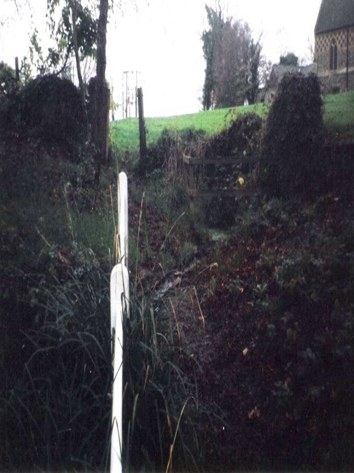
If you wish to find it park the car at the church and follow the footpath beside the church and after crossing the stream and style turn right and continue along the woods passing the information centre (where a wooden box holds maps) and then after a few feet one reaches a small clearing and a path leads to the right into the woods. Take this and this will lead to the well.

Archaeology & History

The origin of the name ‘Knapwell’ is unclear: Cnapa may be the name of the first settler, or simply ‘boy’ ‘moneylender’ or even ‘mound’ referring to the earthworks to the end of the present village.  The site is doubtless ancient and probably pre-Christian origin. Interestingly, one wonders whether the boy meaning is the correct one considering another Cambridgeshire site, the Barnwell on the outskirts of Cambridge has the same suggested origin. It may suggest that the local tribes here perhaps washed their infants in its water in a ritual fashion. There is some evidence of wells associated with ritual washing in other locales so it is possible. Knapwell is first mentioned in a will by A.D. 1000, and the settlement is noted in the Domesday Book of 1086 as Chenewelle, being held by Abbot of St Benedict of Ramsey.  However, this was the estate not the well so nothing should be implied from Ramsey Abbey’s ownership.

The spring produces copious but sluggish red water and is protected  by a red brick domed or arched well house similar to those of Holywell and Longstanton. When I visited the well is in fear of collapsing, and had deteriorated over a number of years, but recent pictures suggest it is in better condition.

Folklore

The well was the sole source of freshwater for both Boxgrove and Knapwell parishes and footpaths still lead from both communities to the well. Knapwell was also known as Little Wellesworth indicating the importance of this and The Victoria County History notes for Knapwell:

‘..named from the chalybeate Red Well, supposedly medicinal, in Boxworth Wood just east of the village.’

Like many Chalybeate springs, healing traditions are attached to it but curiously no details are recorded.

The water was well thought of well into the 20th century, for the Parish guidebook, KNAPWELL VILLAGE And The Parish Church of All Saints (1978) notes:

“Within living memory a drinking cup used to hang on the small brick arch over the spot where the spring rises.”

Copyright © Pixyledpublications

Re-posted from the following blog

http://insearchofholywellsandhealingsprings.wordpress.com/2014/08/19/one-for-the-children-or-the-moneylenders-the-old-red-well-of-knapwell/

Forthcoming from Holy Wells and healing springs of Huntingdonshire


Market Cross, Halesowen, Worcestershire

Cross:  OS Grid Reference – SO 9666 8356

Archaeology & History

Halesowen Cross, when it stood in the village

Halesowen Cross, when it stood in the village

The history of this probable late-medieval monument is fragmentary.  It presently stands in the southeast corner of St John the Baptist churchyard, but used to be in the middle of the old village (when the town actually was a village!).  First erected in 1540 CE, the Victoria County History survey suggested that it may have marked an old boundary.  David Eades (1999) gives the most decent account of the monument, which stands more than nine-feet high and has been re-positioned onto stone steps.  He told:

“It marked the town’s market and fair and may once have come originally from Halesowen Abbey.  It was once possibly more ornate, but religious symbols may have been removed during the Reformation.  After a gale on 22 February, 1908, during which the cross blew down, it was dumped on a rubbish tip.  A local solicitor and clerk to the justices, Mr Alfred Homfrey, rescued it, and Mr Job Garratt, the owner of New Hawne Colliery, paid for its recovery and resurrection in the churchyard.”

References:

  1. Eades, David L., Halesowen, Sutton: London 1999.
  2. Frederick W. Hackwood, Oldbury and Round About in the Worcestershire Corner of the Black Country, Cornish Brothers 1915.

© Paul BennettThe Northern Antiquarian 2016