Maypole (destroyed): OS Grid Reference – SE 2068 2672
Archaeology & History
As in countless villages and towns across the British Isles, Gomersal also once had its maypole near or at the village centre. We don’t know when the first maypole was erected in the village and many local sites were openly destroyed by rampant christian puritans and similar idiots. It stood not far from the Moor Lane Well and was described by the regional historian H.A. Cadman (1930), who told:
“The Maypole was at the top of Moor Lane and one can imagine the welkin echoing to the very old song:
‘Come lasses and lads take leave of your dads
And away to the maypole hie.
For every fair has a sweetheart there
And the fiddlers standing by.
For Willy shall dance with Jane
And Johnny has got his Joan.
To trip it, trip it, trip it, trip it,
Trip it up and down.’
Yet as with maypoles up and down the land, testosterone-fuelled Springtime fall-outs happened. Mr Cadman told:
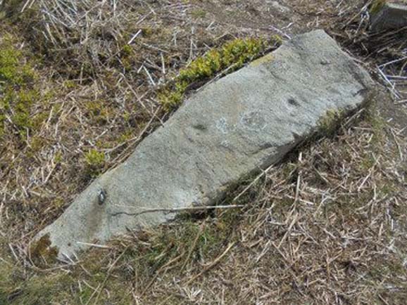
“Very often May Day gatherings ended up with fights. Great jealousy always existed between the inhabitants of Great Gomersal, Little Gomersal and Spen. There is a tradition which has been handed down that the last Maypole in this district stood on Liversedge Green. This Maypole was demolished in a fight by the Gomersalians and there is a similar tradition about the Maypole on Cleckheaton Green, so as Mr Frank Peel says, “It is evident that ancient inhabitants of Gomersal were more pugnacious than their neighbours.” I have no evidence when the Gomersal Maypole ceased to exist, but there is abundant evidence to prove that there was one in Gomersal, the proof being that the vane is now in Batley Museum. It is in the form of a fish.”
If anyone has any further information on this important relic, or its history, please let us know.
References:
Cadman, H. Ashwell, Gomersal, Past and Present, Hunters Armley: Leeds 1930.
Healing Well (lost): OS Grid Reference – SE 209 260?
Archaeology & History
This bizarre-sounding well owed its name—if we are to accept H.A. Cadman’s (1930) version of history—to the local land-owner,
“Joseph Mortimer and it was so-called because Mortimer’s christian name was Doidy Poidy.”
But this seems unlikely. The term ‘doidy’ is a local dialect word, seemingly found only in West Yorkshire, meaning ‘an overdressed person, especially female,’ (Haigh 1928), with doidy-poidy being rhyming slang for the same thing. The english dialect magus, Joseph Wright (1900), proclaimed the same derivative, “a badly dressed woman, a dowdy.” So it may have been that this title was endowed upon Mortimer’s wife.
Cadman told that the Doidy Poidy Well was one of the “chief wells” of Gomersal, implying that its waters were good and strong. Its existence on what was known as “the old feasting grounds” may have played a part in the “public rejoicings which last for days… The feast was on the Monday on or before Lady Day.” (March 25th, around spring equinox) However, Cadman assures us that the celebrations were started “when the Gomersal Cloth Hall was opened,” telling us that “this feast or fair is not therefore an ecclesiastical one.”
The exact whereabouts of the Doidy Poidy Well remains a mystery (the map-link, above, shows an approximation from the middle of Gomersal).
References:
Cadman, H. Ashwell, Gomersal, Past and Present, Hunters Armley: Leeds 1930.
Haigh, W.E., A New Glossary on the Dialect of the Huddersfield District, Oxford University Press 1928.
Wright, Joseph (ed.), English Dialect Dictionary – volume 2, Henry Frowde: London 1900.
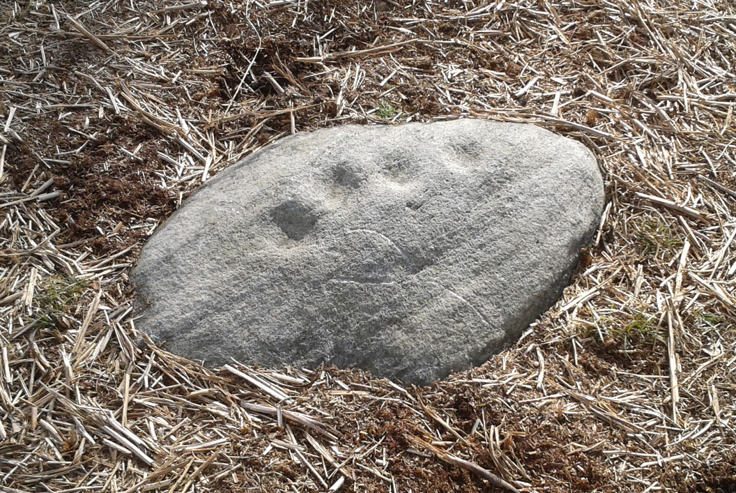
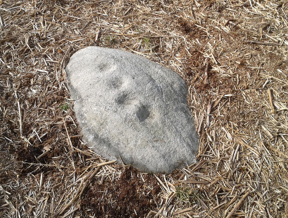
A carving that I first visited when I was a child – but one which, curiously, caught my attention. The small arc of four cup-marks that you can see on the stone was an integral feature of other carvings in this particular region—though not all, of course. It seemed to me at the time that it had symbolic significance, as the arc occurred in a number of other Baildon petroglyphs. Astronomy was my fetish at that time and so I saw the arc as solar or stellar movements across the sky, represented by the cup-markings. It was one of many fascinating Rorschach’s that I encountered, just as rock art students across the world do when looking at these ancient carvings. However, the simple symbolism of this and similar nearby carvings has stuck and plays under my skin somewhat: one of those curious non-egoic tickles, constantly nudging away, as if there’s something in it, but being looked at from the wrong angle…
John Hedges 1986 sketch
Looking down at the cups
Anyway… All we have here is a primary design of four cup-marks reaching across a small earthfast stone. Other simple carvings are found close by and there are the remains of several prehistoric cairns circles within a few hundred yards. Beneath the deep bracken-mass, it is highly probable that other ancient remains remain hidden.
The carving was first recognised in one of Sidney Jackson’s (1958) archaeology bimbles in the 1950s with his bunch of northern antiquarians from Cartwright Hall, Bradford. It later found its way into the survey of John Hedges (1986) where he described it, simply:
“Small, lozenge-shaped, smooth grit rock, sloping NW-SE into grass and bracken, four symmetrical cups in slight curve.”
References:
Baildon, W. Paley, Baildon and the Baildons – parts 1-15, Adelphi: London 1913-1926.
Bennett, Paul, Of Cups and Rings and Things, unpublished: Shipley 1981.
Bennett, Paul, Megalithic Ramblings between Ilkley and Baildon, unpublished: Shipley 1982.
Boughey, Keith & Vickerman, E.A., Prehistoric Rock Art of the West Riding, WYAS: Leeds 2003.
Cowling, Eric T., Rombald’s Way, William Walker: Otley 1946.
Hedges, John, The Carved Rocks on Rombald’s Moor, WYMCC: Wakefield 1986.
Jackson, Sidney, “Cup-Marked Boulders, Baildon Moor,” in Cartwright Hall Archaeology Group Bulletin, 3:2, 1958.
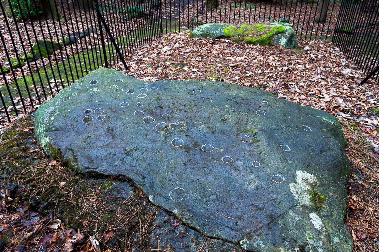
Panorama Stone 228, with cups highlighted (after James Elkington)
Come out of Ilkley/bus train station and turn right for less than 50 yards, turning left up towards White Wells. Go up here for less than 100 yards, taking your first right and walk 300 yards up Queens Road until you reach the St. Margaret’s church on the left-hand side. On the other side of the road, as well as a bench to sit on, surrounded by trees is a small enclosed bit with spiky railings with Panorama Stones 227, 228 and 229 all therein: the one in the centre being the one we’re dealing with here.
Archaeology & History
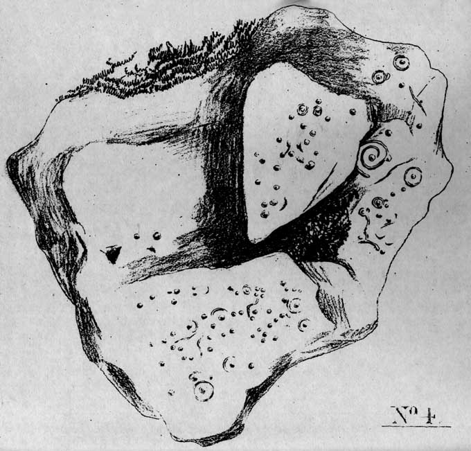
Originally located ¾-miles (1.2km) WSW of its present position in Panorama Woods (at roughly SE 10272 46995), along with its petroglyphic compatriots in this cage, the carving was moved here in 1890 when a Dr. Little—medical officer at Ben Rhydding Hydro—bought the stones for £10 from the owner of the land at Panorama Rocks, as the area in which the stones lived was due to be vandalized and destroyed. Thankfully the said Dr Little was thoughtful and as a result of his payment he had some of the stones saved and moved into their present position. However, this carving is but a fragment of its former self.
John Hedges 1986 sketchClose-up of cups (James Elkington)
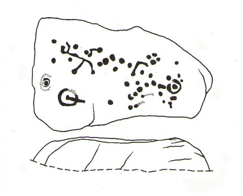
It was originally to be seen within a large prehistoric enclosure—which was completely destroyed when rich houses were built hereby, without any evaluation of the site ever being made. But particularly impressive is the fact that this now enclosed sedated stone carving was originally the large rocky base for a small rocking stone, which also had cup-markings on it and a faint cup-and-ring. This is very unusual indeed – and perhaps unique in Britain? Thankfully, several Victorian antiquarians visited and made notes and a sketch of the site before it was uprooted and a large section of it destroyed. In J. Romilly Allen’s article (1879) he told that, just a couple of yards from the more famous and ornate Panorama Stone (229), a
“second stone is of irregular shape, measuring 15ft by 12ft, and supporting a smaller stone of triangular shape 6ft long by 4ft broad. Both upper and under stone are covered with cups and rings, but the sculptures have suffered much from exposure. The superimposed rock has eleven cups, two of which are surrounded by rings. The under stone has 42 cups, nine of which have rings. Amongst these are two unusually fine examples, one has an oval cup 5in by 4in, surrounded by two rings, the diameter of the outer ring being 1ft 3in. Another has a circular cup 3in diameter, and five concentric rings, the outer ring being 1ft 5in across.”
J.T Dales 1878 sketch, with CR227 on top of itOriginal location of stone
In a sketch of the site by J. Thornton Dale done about the same time as Allen’s visit, and reproduced here (apologies for the poor quality), the “five concentric rings” that Mr Allen mentioned are not shown, but clearly a spiral design had been seen by Mr Dale’s eyes. Fascinating…. The large mass of carvings immediately left of the spiral is in fact the smaller upper stone known by modern archaeologists as carving 227.
Today, all we can see of this petroglyph are two cup-and-rings, and one faint double-cup-and-ring; several incomplete rings or arcs, and at least another 30 single cup-marks, some of which have short limes running to or from them. The rest of original stone base with its other multiple rings or spiral design were obviously destroyed.
As with many of the Ilkley carvings, Boughey & Vickerman’s (2003) description barely does the stone justice. They described it simply:
“Large rock, now set in concrete base, the surface rapidly deteriorating. Over forty cups, three with single rings, one showing traces of a second, grooves.”
The mightily impressive Panorama 229 carving sits next to this one and is truly worth checking out!
References:
Allen, J. Romilly, “The Prehistoric Rock Sculptures of Ilkley,” in Journal of British Archaeological Association, volume 35, 1879.
Bennett, Paul, The Panorama Stones, Ilkley, TNA: Yorkshire 2012.
Bennett, Paul, Aboriginal Rock Carvings of Ilkley and District, forthcoming.
Boughey, Keith & Vickerman, E.A., Prehistoric Rock Art of the West Riding, WYAS: Leeds 2003.
Cowling, Eric T., Rombald’s Way, William Walker: Otley 1946.
Downer, A.C., “Yorkshire Archaeological and Topographical Association,” in Leeds Mercury, August 28, 1884.
Hadingham, Evan, Ancient Carvings in Britain, Souvenir Press: London 1974.
Hedges, John, The Carved Rocks on Rombald’s Moor, WYMCC: Wakefield 1986.
Heywood, Nathan, “The Cup and Ring Stones of the Panorama Rocks”, in Transactions Lancashire & Cheshire Antiquarian Society, Manchester 1889.
Speight, Harry, Upper Wharfedale, Elliott Stock: London 1900.
Acknowledgements: With huge thanks to both Dr Stefan Maeder for help in cleaning up the stones; and to James Elkington for taking the photos and allowing ’em for use them in this site profile.
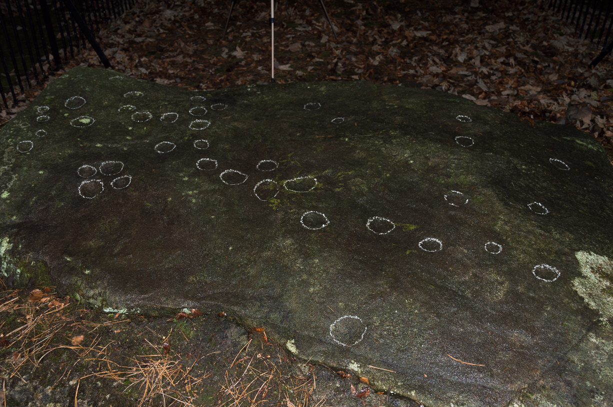
Cup-marked stone, East Morton (photo thanks, Sue Patchett)
From the expanding village of East Morton, by the school at the west-end of the village, walk up the narrow Street Lane for nearly 600 yards, past the houses, until you reach a footpath on your left that takes you across the fields. Walk along here (following the line of walling) for 250 yards, then, take a sharp left and down the field for 55 yards (50m) until, right beneath the power lines, you’ll find the rock in question.
Archaeology & History
This is one in a small, little-known cluster of petroglyphs on the western outskirts of East Morton. It is located at the base of what are thought to be remnants of Iron Age walling. Carved onto an elongated earthfast stone are a number of very well-preserved cup-marks, with what seems to be a faint carved pecked line running out from one of the southernmost cup-marks and curving back on itself (we could do with a good sketch artist getting us a good drawing of this). You can see this faint line on the far-left side of the stone in Sue’s photo above.
Hedges 1986 sketch
The petroglyph was rediscovered by the northern antiquarian Stuart Feather (1959) in one of his many sojourns exploring the prehistoric remains of the area. In John Hedges’ (1986) survey, the carving was described simply as:
“Triangular smooth grit rock with fairly flat top on which are twenty cups, not all clear, some large and oval, a few grooves.”
Boughey & Vickerman’s survey (2003) made no note of any additional features on the petroglyph.
References:
Boughey, Keith & Vickerman, E.A., Prehistoric Rock Art of the West Riding, WYAS: Wakefield 2003.
Feather, Stuart, “Bronze Age Rock Carvings,” in Keighley News, March 7, 1959.
Hedges, John (ed.), The Carved Rocks on Rombalds Moor, WYMCC: Wakefield 1986.
Jackson, Sidney, “Massive Walling at East Morton,” in Cartwright Hall Archaeology Group Bulletin, 5:9, 1960.
Jackson, Sidney, “East Morton Ancient Walls,” in Cartwright Hall Archaeology Group Bulletin, 6:9, 1961.
Acknowledgements: Huge thanks to Sue Patchett for use of her photo.
Cup-and-rings on gatepost (photo credit, Dave Whittaker)
From Ilkley, follow the same directions as if you’re going up to the superb Swastika Stone. Keep walking on the footpath, west, for 65 yards (59m), then walk into the heather on your left. Barely 5 yards in, you’ll see this fallen standing stone or gatepost.
Archaeology & History
First described in one of Stuart Feather’s (1964) old rambles, I first saw this stone in my late-teens and was as puzzled by it then as I am today. Upon an obviously worked stone that may once have stood upright (or was intended to do), two faint and incomplete cup-and-rings were carved – but when exactly? If this stone was cut from a larger rock into its present shape, were the petroglyphs already on it, or were they done when the ‘gatepost’ was created?
It was first described in one of Stuart Feather’s (1964) rambles up here and later included in Hedges’ (1986) survey, where he told it to be a, “recumbent gatepost with one cup with almost complete ring and one cup with vestigial ring.” Boughey & Vickerman’s (2003) survey added little more. And when a group calling itself Carved Stones Investigation got itself about £250,000 to “investigate” the Ilkley petroglyphs, I was hoping that they could have at least turned this stone over to see if other carvings were on the stone – but they just revisited all those found by others, made a new list, and took the money to be honest (no website and no book – as they should’ve done). Thankfully, local folk are having a look at this and others and doing the work they should have. Check it out when you’re next up at the Swastika.
References:
Bennett, Paul, Megalithic Ramblings between Ilkley and Baildon, unpublished: Shipley 1982.
Boughey, Keith & Vickerman, E.A., Prehistoric Rock Art of the West Riding, WYAS: Wakefield 2003.
Feather, Stuart, “Mid-Wharfedale Cup-and-Ring Markings: no.26, 27, 28 – Black Pots, High Moor, Silsden, near Keighley,” in Cartwright Hall Archaeology Group Bulletin, 9:10, 1964.
Hedges, John, The Carved Rocks on Rombalds Moor, WYMCC: Wakefield 1986.
Acknowledgements: Huge thanks to Dave Whittaker for the photo. Good luck with the plans fellas.
Standing Stone? (destroyed): OS Grid Reference – SE 2428 2329
Archaeology & History
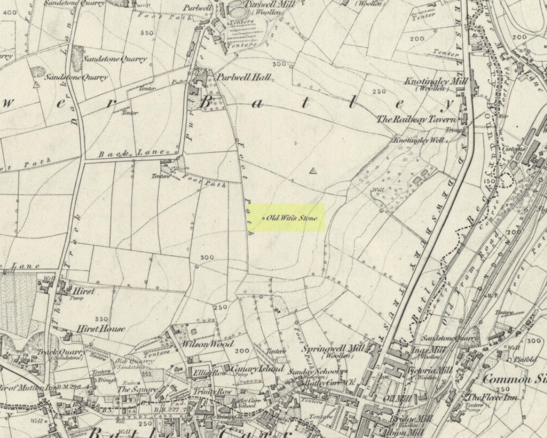
Old Wifes Stone on 1854 map
My first hint at the existence of this once valuable archaeological relic came as a result of me seeking out the history and folklore of some hitherto unknown, forgotten holy wells in the Batley and Dewsbury area. I located the material I was looking for on the old wells, but my fortuitous discovery of this site, the Old Wife’s Stone, blew me away!
It was the place-name of ‘Carlinghow’ about one mile northwest of the grid-reference above that initially caught my attention. From an antiquarian or occultist’s viewpoint, it’s intriguing on two counts: the first is the element ‘how‘ in Carlinghow, which can mean a variety of things, but across the Pennines tends to relate to either an ancient tribal or council meeting place, or a prehistoric burial cairn: an element that wasn’t lost in the giant archaeology survey of West Yorkshire by Faull & Moorhouse (1981). But the first part of this place-name, ‘carling‘, was the exciting element to me; for it means ‘old woman,’ ‘old hag,’ ‘witch’ or cailleach! The cailleach (to those who don’t know) was the prima mater: the Great Mother deity of our pre-christian British ancestors. Meaning that Carlinghow hill was a hugely important sacred site no less—right in the heart of industrial West Yorkshire! What is even more intriguing—or perhaps surprising—is that we have no record of such a powerful mythic creature anywhere in local folklore… Or so it first seemed…
Memory told me that no such prehistoric remains were recorded anywhere in that area—and certainly no prehistoric tombs. I scoured through my library just to triple-check, and found the archaeological records as silent as I first thought. Just to make sure I spent a day at the Central Library, where again I found nothing… So then I explored the region on the modern OS-maps, only to find that much of the area where the Carlinghow place-name existed was, surprisingly, still untouched by housing and similar modern pollutants. This was a great surprise to say the least. And so to check for any potential archaeological sites which might once have been in the Carlinghow area, I turned to the large-scale 1850 OS-maps (6-inch to the mile).
This is when I came across the Old Wife’s Stone, marked in the middle of fields on the outskirts of old Batley. There was no notice of it being a standing stone, or a simple boulder, or archaeological relic—nothing. But its place-name compatriot of ‘Carlinghow’ was the rising hill about a mile to the northwest. In days of olde, if Carlinghow was indeed the ‘burial tomb of the Old Woman’ or ‘meeting place of the cailleach’ (or whatever variants on the theme it may have been), it may have marked the setting sun on the longest day of the year if you had been standing at the Old Wife’s Stone – a midsummer sunset marker no less. (There are other ancient and legendary sites scattering northern England and beyond that are dedicated to the Cailleach, like the Old Woman Stone in Derbyshire, the Old Wife’s Neck in North Yorkshire, the Carlin Stone in Stirlingshire, the Old Woman Stone at Todmorden, Carlin Stone of Loch Elrig and many more.)
As if these curious ingredients weren’t enough to imply something existed in the heathen pantheon of Batley before the Industrialists swept away our indigenous history, we find echoes of the ‘Old Woman’ yet again, immediately east; this time where the animism of water and trees enfolded Her mythos in local rites and traditions, thankfully captured by the pens of several writers, and transmuted into another guise—but undeniably Her! But that, as they say, is for another day and another site profile…
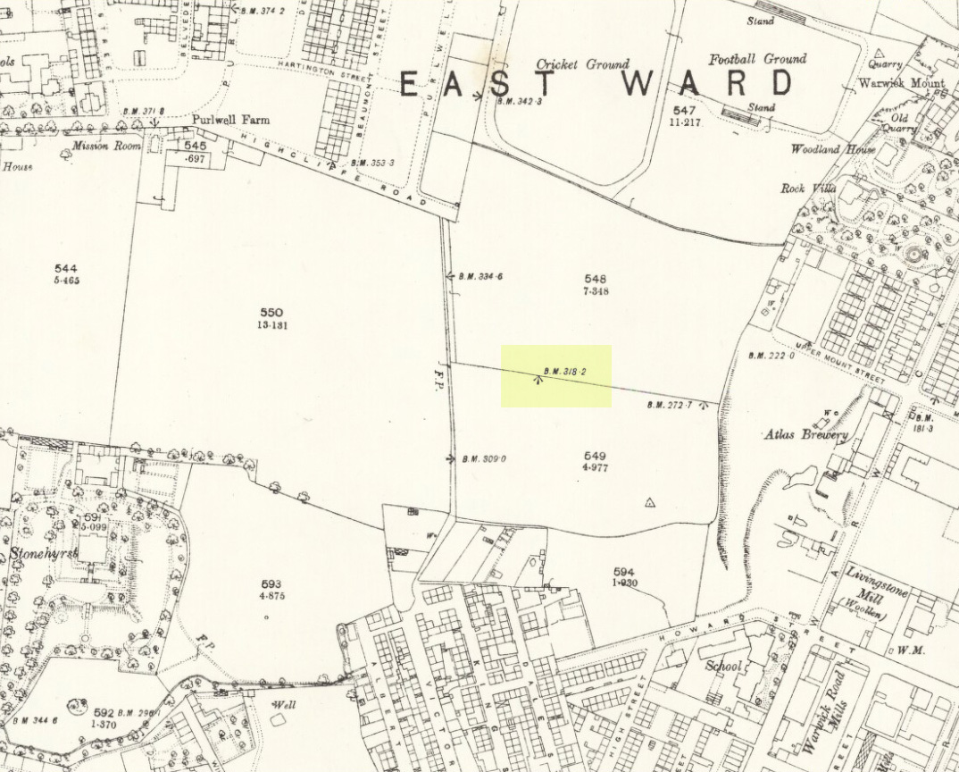
Position of stone in 1894
So is our Old Wife’s Stone (or for that matter, Carlinghow’s old tomb) still in evidence? A school has been built where it was highlighted on the 1854 OS-map and, from the accounts of local people, seems to have long since disappeared. The stone looks to have been incorporated into a length of walling, sometime between 1854 and 1888, and a bench-mark of “BM 318.2” carved onto it. But when the Ordnance Survey lads re-surveyed the area in 1905, this had gone. I have been unable to find any more information about this site and hope that, one day, a fellow antiquarian or occult historian might be able to unravel more of its forgotten mythic history.
References:
Faull, M.L. & Moorhouse, S.A. (eds), West Yorkshire: An Archaeological Survey to 1500 AD – volume 1, WYMCC: Wakefield 1981.
Goodall, Armitage, Place-Names of South-west Yorkshire, Cambridge University Press 1914.
Keighley, J.J., ‘The Prehistoric Period’, in Faull & Moorhouse, 1981.
o’ Crualaoich, Gearoid, The Book of the Cailleach, Cork University Press 2004.
Smith, A.H., English Place-Name Elements – volume 2, Cambridge University Press 1956.
Smith, A.H., The Place-Names of the West Riding of Yorkshire – volume 2, Cambridge University Press 1961.
Wright, Joseph, English Dialect Dictionary – volume 1, Henry Frowde: London 1898.
Acknowledgements: Many thanks for the assistance of Simon Roadnight and Julia King in the Batley History Group.
From the B6265 valley road between Bingley and Keighley, just near Riddlesden Hall, take the road up and over the canal into Riddlesden, bearing left up past West Riddlesden Hall and up Banks Lane. As you reach the T-junction at the top, where you hit the Silsden Road that goes round the moors, park up. Cross the road and follow the footpath up the field, go over a stile and continue up the track to the next gate. Once through this gate, go across the field to another gate which leads to a narrow track. The stone is situated on the left hand side about 75 yards from the gate.
Archaeology & History
Not previously recorded, this carving comprises of a large cup on the vertical surface of the stone with a faint surrounding ring mark.
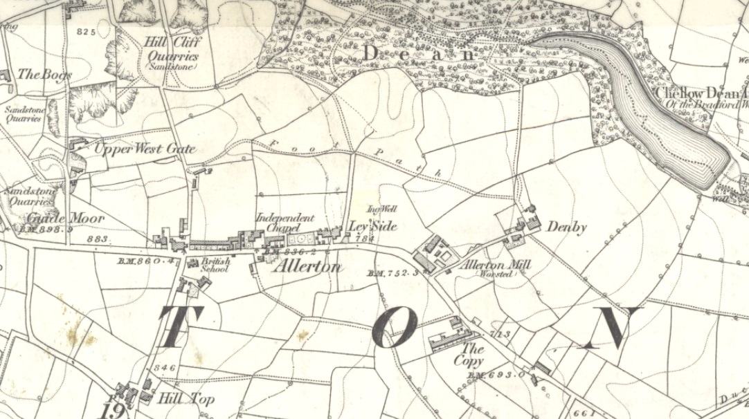
Healing Well (destroyed): OS Grid Reference – SE 1174 3443
Archaeology & History
Ing Well on 1852 map
This ‘Well of the Meadow”, or Ing Well, is one of countless springs in and around the Bradford metropolis that have been destroyed by that thing they call ‘development’. It was one of the main water sources for the villagers of Allerton village in the 19th century and earlier. Highlighted on the 1852 OS-map of the region, a singular footpath once led to the waters and no further. There appear to be no antiquarian or historical references detailing its traditions or medicinal qualities—unless of course, you know different.
The name Ing Wells is one of the most common of all titles given to water supplies in England, meaning having the same meaning and general history just about everywhere it occurs. The place-name itself was given extensive attention in two separate studies by Eilert Ekwall (1962) and Sigurd Karlstrom (1927).
References:
Ekwall, Eilert, English Place-Names in -Ing, Lund: Uppsala 1962.
Karlstrom, Sigurd, Old English Compound Place-Names in -Ing, Lund: Uppsala 1927.
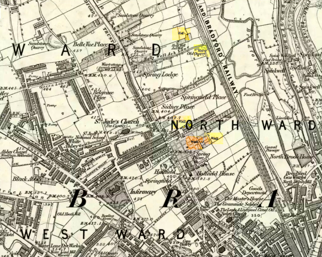
Sacred Well (lost): OS Grid Reference – SE 160 339
Archaeology & History
Which one is the Cruckleswell?
In an essay by great regional historian Harry Speight (1912) on the ancient tracks of Bradford and district, he mentions this “Cruckleswell” which was first described in 1602. Mentioned again in 1612 land deeds and several times thereafter, the site has long gone (been built over), but may have been a place where local people ascribed there being water spirits, or naiads.
Although the local historian W.E. Preston (1932) described the place as being in fields between Manningham Stoop (an old boundary stone, now lost) and Hallfield Cross (perhaps an old stone cross site, also lost), a more detailed article appeared a few years later by Wilfrid Robertshaw (1935), telling of its approximate location. He wrote:
“The interesting field-name of Cruckleswell occurs in 1664. Cruckleswell was situated between Manningham Stoope and Hallfield Cross. The latter name is here applied to some closes of land near the Bradford-Manningham boundary and not to a monument; but from this qualifying statement must not be inferred the opinion that a stone or wooden cross of the name never existed. From Manningham Stoope, whose location I have not traced, a lane led to Fair Gapp, which was just within the town of Bradford; but in 1686 there was a close called the Stoope, which adjoined Manningham Lower Lane on the left-hand side from Bradford to Manningham. The occupiers of Cruckleswells were ordered by the jurors of the Bradford Manor Court to take in the water which ran by their premises. The occurrence of a water-course thereabouts, together with the name, Cruckleswell, suggests that here, as in the Panewell Feilde, was a holy well of a kind. Perhaps the derivation of the name may be found in the Yorkshire dialect word ‘crukle,’ meaning to make crooked, or to bend or twist. In a sense, therefore, Cruckleswell was another pin well, into which bent of ‘cruckled’ pins were cast. Cruckleswells, or Crookewells, as the three closes of land were called in a deed of 1658, were then granted by Tempest Brighouse, of Bilbie in the county of Nottingham, to James Mitchell of Bradford, yeoman. But…I have found a deed of sale by Christopher Pighells of Bradford, yeoman, to John Nicholls of Horton, clerk, of the close of land called Cruckleswell… Nicholls purchased Cruckleswell in 1612, the year before Saxton produced his plan, on which the small field is shown adjoining others belonging to Pighells. Thus the plan fixes the location of Cruckleswell; it adjoined the east side of the highway leading from Bradford to Frizinghall and was just within the Manningham township.”
This would put it close to the Holy Well Ash well and its long-lost standing stone. The 1852 OS-map of this area shows an unnamed well between the Holy Well Ash and the boundary line, as highlighted above; but another unnamed well is to the north of the holy well. If we cross over the boundary line south and out of Manningham, three other wells existed less than 200 yards away. Anyone of these may have been the Cruckleswell.
Mr Robertson’s idea on the word ‘cruckle’ is echoed in A.H. Smith’s (1961) place-name analysis of the site, where he relates how the word is “possibly connected with the obsolete crookle, ‘to crook, bed.'” This is shown to be the case in Thomas Wright’s (1898) gigantic tome. And as “cruckling” pins was a common animistic practice in earlier centuries, this derivation of it—as being a well where offerings were given to the spirit of the waters—is not unlikely.
References:
Preston, W.E., ‘Some Local Holy Wells,’ in Bradford Antiquary, June 1932.
Robertshaw, Wilfrid (ed.), West Yorkshire Deeds (2 volumes), Bradford Historical & Antiquarian Society 1936.
Shepherd, Val, Historic Wells of Bradford, Heart of Albion: Wymeswold 1995.
Smith, A.H., The Place-Names of the West Riding of Yorkshire– volume 3, Cambridge University Press 1961.
Speight, Harry, ‘Ancient Streets and Lanes of Bradford as Portrayed in the Manor Court Rolls,’ in Bradford Antiquary, New Series 3, 1912.
Wright, Thomas, English Dialect Dictionary – volume 1, Henry Frowde: Oxford 1898.