In Mr Kennedy’s book (1927) on the folklore of Strathtay, he informed that this Witches Stone was examined and taken to Edinburgh sometime in the 19th Century, but returned to its home by a local man called Mr McNaughton who lived at Bail-an-eas. The stone was restored close to the walls in which it was first found. He also told us the following:
“In bygone days the witches of Strathtay amd Grandtully had their great meeting place at Tulliepourie. There the Witches’ Stone…with its round bowl-shaped holes, is still in evidence. Satan attended and assumed the shape of a he-goat; but going to the meeting he is said to have rolled along in the shape of a large cart-wheel – gyrating and describing the figure eight. This must have been an exceedingly interesting site! The orgies that ensued at these meetings were disgustingly wicked!”
The fairy folk, whose main home was the hill of Craig Scriadlain further uphill from here, would also have their revelries here. Many of the other sites near here were also used by the same little people of Scriadlain.
References:
Kennedy, James, Folklore and Reminiscences of Strathtay and Grandtully, Munro Press: Perth 1927.
Bronze Torc found at siteDetails drawn by R.Sheppard
In August, 1984, a Mr James Rickett was out with his metal-detector, scanning the Swinston woodland area south of Dinnington, when he was fortunate to locate a superb, ornamental ‘Celtic’-design bronze torc, thought to be of Romano-British origin, and believed to have been made in either the 1st or 2nd century AD. Following Mr Rickett’s discovery, a small team from the Sheffield City Museum and the South Yorkshire Archaeoloogy Unit got off their backsides and did a survey of the region where the torc had been found —and they weren’t to be disappointed!
An initial assumption based on place-name evidences led them to believe that a settlement of the Saxon period may once have been here; but their investigations
“located the earthworks of a sub-rectangular enclosure, 40m by 25m, and possible fields about 140m south of the discovery site (South Yorkshire SMR record no.PI3021). The enclosure is sub-divided into a smaller and a larger compound with no surface evidence for ditches associated with the stony banks, which enclose a total area of about 0.1 hectares. In both size and shape it compares closely with the class of very numerous small ditched enclosures… The origins of some may lie in the late Iron Age, but fieldwork and excavation have produced predominantly Romano-British material. Other local metal detector finds, some from this enclosure, include first- to fourth-century Romano-British material.”
References:
Beswick, Pauline, Megaw, M.R., Megaw, J.V.S. & Northover, Peter, “A Decorated Late Iron Age Torc from Dinnington, South Yorkshire,” in The Antiquaries Journal, 70:1, 1990.
There are a number of sacred and healing wells on this small island, but this site in particular was deemed magickal by folk from far and wide. Found on the northwest slopes of Cnoc Largie (around which are other heathen spots) this legendary site had an attendant keeper of the well:
“an aged female direach, or guardian, whose uncanny powers could be commanded by a small offering of silver. Following this the cover of the sacred well would be removed in order that its waters might be ceremonially cleansed with a white clamshell prior to being stirred three times, sunwise, to the accompaniment of ritual incantations. Then three shell-fulls of the sacred water would be hurled aloft in the direction of the desired wind which, before the day was out, invariably appeared.”
This simple ritual obviously tells that it was a heathen site, seemingly one for divination and magick. Another piece of folklore (found at other wells) told that if the cover on the well were left unattended, its waters could overflow and flood the entire island.
References:
Anonymous, Exploring Historic Kintyre and the Isle of Gigha, Harlequin Press: Oban n.d.
On this “Isle of the Gods” — as some historians proclaim Gigha to mean — the ancient rites and ceremonies of local folk continued until pretty recent times. One writer narrated some intriguing pre-christian events connected to this curious and little-known place, speaking of indigenous heathen rites:
“These are in fact known to have persisted on the island until well into the early part of the (19th) century when Irish fishermen could still be seen climbing the little hill of Moinean Sitheil, in the sacred Moss of Peace below Ardminish, to pay homage to the “Old Ones” of Gigha: a pair of ancient legend-shrouded stones known as the Bodach and the Cailleach, that from time immemorial have stood upon a low green knoll below the farm of Achamore.
“Through the countless ages the strange jug-headed little Bodach and his smaller consort have kept steadfast vigil over Gigha: their mysterious aura said to guarantee its continuing fertility and prosperity as they link the thriving island of today with beliefs and traditions having roots in the earth-cults and sun-worship of primeval times. In the past folk would have honoured them with offerings of meal or milk and even now they still command considerable local affectation and respect, albeit expressed in less overtly pagan ways. And so they stand as ever upon their tiny hillock gazing out across tumbling terraces of old Cantereoch and beautiful Ardlamey Bay, inscrutable and silent, yet with a strangely ‘knowing’ air impossible to define.”
References:
Anonymous, Exploring Historic Kintyre and the Isle of Gigha, Harlequin Press: Oban n.d.
This old cross was demolished long since, but I think it’s important to rejunevate a memory of its existence back into our times. Little has been written about the site as it was destroyed more than 200 years ago and images of the edifice are rare indeed! It was found near the modern centre of the city and although this ornate-looking thirty-foot tall cross was obviously impressive, an even earlier upright stone stood here in the 13th and 14th century. But this new carved monument took precedence over its older and lesser upright. First described — I think! — by Thomas Gent (1730), he told us that,
“The old cross stood towards the Kennel, against the middle of the market. The lower part was an octagon, had an ascent of six high steps, covered with Tyles for Butchers, higher up with nitches, in which had been effigies and a small pillar above with four Dials and over them a Fane.”
A few years later when Francis Drake (1788) described the same monument, he added very few extra details; though told us it had five steps and not six — but this seems to have been an error on his behalf. In C.B. Knight’s (1944) work we have what seems to be the most complete historical description of this lost stone edifice. He wrote:
“In 1429 a new stone cross had been erected in Thursday Market in place of its predecessor by Marion Braythwayt, widow of John Braythwayt, who was Lord Mayor in 1394… This Cross was described by a writer in 1683 as “a fair Cross of stone, built upon the ascent of five steps, and hath neatly cut in stone a turret or battlement eight square, upon which is placed a round pillar with a four-square stone upon the top, which hath a sundial placed upon every square, and a vane above. The Cross hath a penthouse round about it, covered over with tile, to shelter the market people in rainy weather, and is supported upon eight posts, upon one of which, on the south side, is fixed an iron yard-wand, the standard measure of the market.” In 1705 the ancient Market Cross…was pulled down.”
References:
Cobb, Gerald, “Note on a Drawing of Thursday Market Cross, York,” in The Antiquaries Journal, 43:1, 1963.
Davies, Robert, Walks about the City of York, Nichols & Sons: Westminster 1880.
Drake, Francis, Eboracum; or the History and Antiquities of the City of York, Wilson & Spence: York 1788.
Gent, Thomas, The Antient and Modern History of the Famous City of York, Thomas Hammond: York 1730.
Knight, Charles Bruton, A History of the City of York, Herald: York & London 1944.
Go up Jura’s only road until it becomes a dirt-track and head along the track to the east to the natural hillock on the coast. You’ll pass the three standing stones of Knockrome before you get to this one, right by the end house.
Archaeology & History
Found in a beautiful setting, this is a thick little stone but is less than four feet tall and it may have had some shapely relationship with one of the hills (Corra Bheinn) on Jura. The Royal Commission (1984) described it merely as, “an erratic boulder measuring 3.1m in girth at the base, and 1.2m in height with its longer axis aligned roughly east and west.” Several other stones can be found nearby.
References:
Royal Commission on the Ancient & Historical Monuments of Scotland, Argyll – volume 5: Islay, Jura, Colonsay and Oronsay, HMSO: Edinburgh 1984.
Follow the same directions as those to reach the small Central Design Stone up past the top-end of Shipley Glen. You’ll notice the small disused quarry just a few yards away, and this partly-covered flat stone lies right at the very edge of the quarry itself.
Archaeology & History
Faint cups on CR-122Plan of CR-122 (after Hedges)
Unless you catch this stone in good light, many of the cups on this design are difficult to make out; but defocus for a bit and they’ll come to you. Around 13 cups have been counted on this stone, with a couple of grooves: one of which descends just by the small arc (a common local feature on Baildon’s carvings), near the eastern side of the stone. A larger basin below this, covered by earth, may or may not be natural. Two of the cups here may have been carved sometime in the late 19th or early 20th century, probably around the time the quarrying was being done.
As is common in some parts of Britain, this carving (and others nearby) was found in association with a small cairn-field, much of which has long since gone.
It’s very probable that there were other petroglyphs close to this one, but which have subsequently been destroyed as a result of the quarrying operations here.
References:
Baildon, W. Paley, Baildon and the Baildons – parts 1-15, Adelphi: London 1913-1926.
Bennett, Paul, Megalithic Ramblings between Ilkley and Baildon, private manuscript: Shipley 1982.
Boughey, Keith & Vickerman, E.A., Prehistoric Rock Art of the West Riding, WYAS: Leeds 2003.
Jackson, Sidney, “Cup-Marked Boulder near the Glovershaw Footpath,” in Cartwright Hall Archaeology Group Bulletin, 2:17, 1957.
Hedges, John, The Carved Rocks on Rombald’s Moor, WYMCC: Wakefield 1986.
This site hasn’t been located. However, if it hasn’t been destroyed by the quarrying on the SW side of the moor, remains of it should still be found amidst the heather and would be a good discovery for any enthusiast.
Archaeology & History
The first notes I found about this place were those by archaeologist Sydney Jackson in 1956, who wrote:
“It would be interesting to know what Dr Richard Richardson, of Bierley Hall, Bradford meant when, writing about 1709, he said that Mr Benjamin Ferrand show him a ‘skirt of stones’ on Harden Moor, near to a row of stones placed in a line nigh two hundred paces in length some two feet above the heath, others hidden beneath it.” (my italics)
The undoubted man-made nature of this row of stones was emphasized by Dr Richardson when he wrote,
“That these stones were placed here by design, no person can doubt; but for what I end cannot conjecture, having never seen anything of this kind before.”
The great Yorkshire historian Harry Speight (1898) also came across the same antiquarian notes many years before and speculated how,
“it may be inferred from this that it had been a double row of stones, like the avenue of Maiden Castle in Swaledale.”
The ‘skirt of stones’ that were described here may be the well-preserved Harden Moor Circle. However in recently finding the short essay of Peter Craik (1907) of Keighley, this idea may need re-assessing, as Craik clearly shows in his survey of the the nearby Catstones Ring earthwork, what he described as the “remains of a cairn” on the northern edge of that ring, giving us a different location for this lost stone row.
However, another potential position for our lost stone row that needs exploring is the one described by Butler Wood following an exploratory visit here with the Bradford historian, William E. Preston, at the beginning of the 20th century. Mr Wood (1905) told of them both coming across some sort of earth-and-stone line “half-a-mile north of” the Catstones Ring, telling:
“Mr W.E. Preston and myself traced a short time ago on Harden Moor, remains of an entrenchment for a distance of 80 or 90 yards. It faces south, and lies near Spring Head Heights. The wall consisting of boulder and earth rising three feet above the soil, but there is no trace of a ditch.”
This is obviously half the length described by Richardson and Ferrand in 1709, but nearly two centuries separate the two accounts (the position of Mr Woods’ line is roughly SE 072 387; whilst that nearer to the Catstones Ring would be nearer SE 069 383).
I’ve searched the tops of this moorland a number of times hoping to locate this seemingly important megalithic stone row, obviously without success. Further searches on the moor are needed after the heather’s been burnt back.
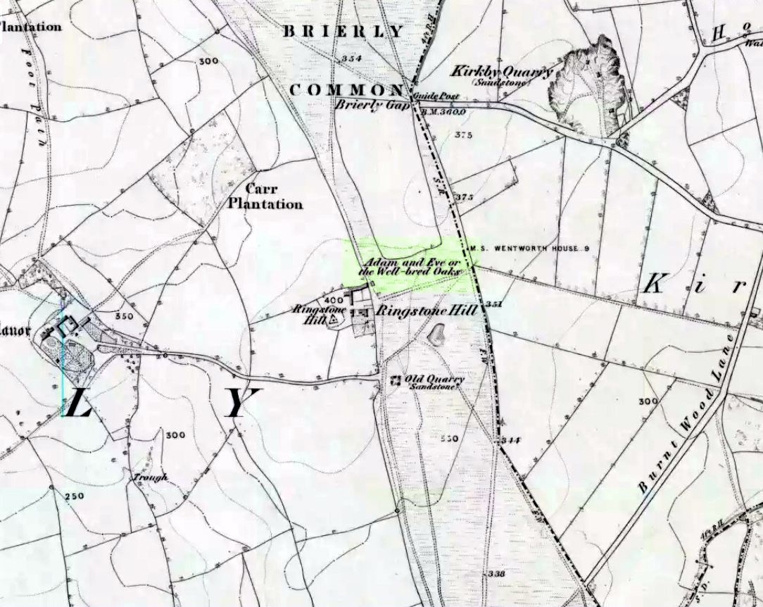
Highlighted on the 1854 Ordnance Survey map close to the township boundary line as Adam & Eve’s Oak, between Brierley and South Kirkby, I can’t find too much about this once great tree. However the Wakefield historian W.S. Banks (1871) told us the following:
“Upon the common at Ringston Hill grows the remarkable ‘old Adam’ oak, much decreased in size in late years. It is an ancient and large tree measuring twenty-seven feet in girth at a yard above the ground. The trunk is hollow and the north side is broken away. Most of the branches are also gone. In 1868 a very large branch was blown off by the wind; but on the southerly side are still some very vigorous limbs.”
The old oak on the 1854 map
Even when Banks wrote this he said how the tree “must be many centuries old.” In the time of King Charles II there used to be an old inn by Adam’s Oak at the foot of Ringston Hill, where the famous highwayman, Nevison (much-loved by many Yorkshire-folk because of his Robin-Hood-like character), used to stay. The inn was owned by one Adam Hawksworth, but was ordered “to have his sign taken down for harbouring Nevison.”
Folklore
W.S. Banks also wrote of this once great tree:
“The people at Brierley tell of Nevison the highwayman lodging in it and hiding stolen treasures in it, things which probably did not happen, though Nevison’s name is connected with Ringston Hill.”
The treasure legend may have more to do with the adjacent stone circle, as we find ‘treasure’ a common motif at such places.
References:
Banks, W.S., Walks in Yorkshire: Wakefield and its Neighbourhood, Longmans, Green Co.: London 1871.
Best visited out of season before the corn’s been planted. It makes it easier to find and doesn’t annoy the land-owner here, who tends to be a decent dood. From Chipping Norton go southeast along the B2046 road to Charlbury. After about 1½ miles take the second right turning down the small country lane. Go slowly down here for less than half a mile, watching the fields on your right. You’re damn close!
Archaeology & History
The Hawk Stone
This impressive, weather-worn, eight-foot tall standing stone stands aloft in the middle of a field due west of the road between Chalford Green and Dean. It’s an excellent monolith and one which, I think, has a lot more occult history known of it than described here. Thought by O.G.S. Crawford (1925) and others in the past to have been “formerly part of a chambered structure,” or prehistoric chambered tomb like that of the Hoar Stone at nearby Enstone, no remains of such a structure unfortunately remain today. It is first illustrated and named on a local map of the region in 1743 CE, and the stone at least has fortunately managed to escape the intense agricultural ravages endemic to this part of the country.
The name “Hawk” stone has been fancied by some to relate to some obscure resemblence to a Hawk, or because there very often are hawks hovering over those upland fields – but these are unlikely. It’s thought by place-name authorities more likely to derive from a corruption of ‘Hoar’ meaning a grey or boundary stone; and as it stands just yards east of the present township boundary line, this derivation seems more probable.
To all lovers of megalithic sites, we highly recommend a visit here!
Folklore
In local folklore and in the opinion of some earlier historians, the Hawk Stone formed an integral part of a stone circle here, but there is little known evidence to substantiate this.
Hawk Stone in summerHawk Stone in winter
A creation legend attached to this site tells that the stone was thrown, or dragged across the land, by a old witch or hag — though we are not told from where. This is a motif found at megalithic sites all across the country (see Bord & Bord 1977; Grinsell 1976, etc). In Corbett’s History of Spelsbury (1962) the author told of the folklore spoken of by one Mr Caleb Lainchbury who
“said the cleft at the top of the Hawk Stone at Dean was supposed to of been made by the chains of the witches who were tied to it and burnt. As witches seem to have been extremely rare in Oxfordshire it cannot have been a very common practise to burn them at Dean; but there may indeed have been some kind of fire ceremonies near the stone.”
Grinsell (1976) also tells how the Hawk Stone has that animistic property, bestowed upon other old monoliths, of coming to life and going “down to the water to drink when it hears the clock strike 12.”
This evidently important and visually impressive monolith also plays an important part in an incredibly precise alignment (ley) running roughly east-west across the landscape. At first, Tom Wilson (1999) thought the alignment had previously gone unnoticed, but later we later found a reference to the same line in an early copy of The Ley Hunter (Cooper 1979). It links up with other important megalithic sites, such as the Hoar Stones at Enstone, Buswell’s thicket, and the ancient Sarsden Cross.
Similarly, when Tom Graves’ (1980) was doing some dowsing experiments at the Rollright stone circle a few miles west, he found what he described as an ‘overground’ (or ley) linking the ring of stones to the Hawk Stone, but no other connecting sites are known along this line.
References:
Bennett, Paul & Wilson, Tom, The Old Stones of Rollright and District, Cockley: London 1999.
Bord, Janet & Colin, The Secret Country, BCA: London 1977.
Cooper, Roy, “Some Oxfordshire Leys,” in The Ley Hunter, 86, 1979.
Corbett, Elsie, A History of Spelsbury, Cheney & Sons: Banbury 1962.
Crawford, O.G.S., The Long Barrows of the Cotswolds, John Bellows: Gloucester 1925.
Gelling, Margaret, The Place-Names of Oxfordshire – volume 2, Cambridge University Press 1954.
Graves, Tom, Needles of Stone, Granada: London 1980.
Grinsell, L.V., Folklore of Prehistoric Sites in Britain, David & Charles: Newton Abbot 1976.