Merlin’s Mount, Marlborough, Wiltshire

Tumulus:  OS Grid Reference – SU 1836 6867

Also Known as:

  1. Marlborough Mount
  2. Merlin’s Barrow
  3. Merlin’s Mound

Getting Here

Pretty simple.  Get to the chapel in front of Marlborough College, and look at the stepped hill in the grounds thereof (with a big hole cut into the top where a water tower once stood).  That’s it!  Please be aware that this monument is on college ground, so it might be worthwhile telephoning them if you wanna wander upon the hill.

Archaeology & History
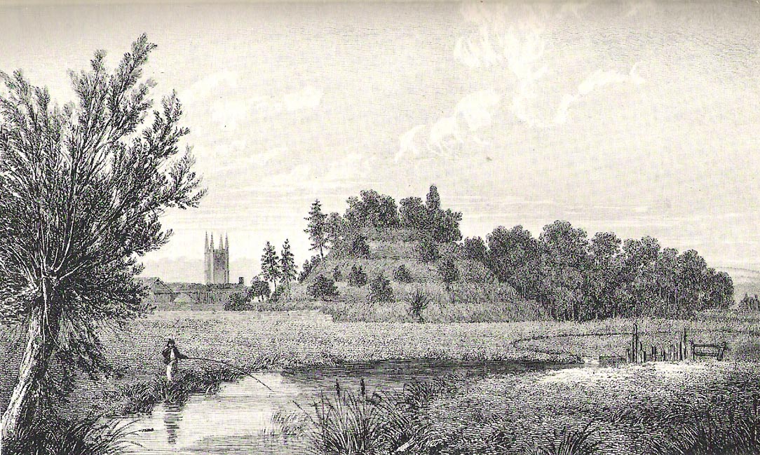
Merlin’s Mount (from Colt-Hoare’s Ancient Wiltshire)

This curious rounded, pyramidal hill is thought by some to have given the town of Marlborough its very name.  Described in Domesday as ‘Merleberge’, which is reckoned to derive from “the hill or barrow of Maerla”: Maerla in this case being a lost olde English name, said in local folklore and tradition to have been our old heathen magickian, Merlin, of Arthurian fame and legend.  Long ago his bones were laid to rest here and this great ‘tomb’ built over him.  We might never know…

The exact nature and date of this mound has yet to be satisfactorily explained.  Commonly ascribed as Norman in origin (based mainly on the notion that it wasn’t mentioned before Domesday and there being motte and bailey ruins here), the finding of Roman remains near its base then led some to think they had built the hill; but when “antler picks used by its prehistoric builders were unearthed in the late nineteenth century and again in 1912 when a trench was cut for the flue of a new engine-house chimney” (Burl 2002), the dates for its origin went a lot further back!

One of the earlier commentators on this archaeological curiosity was Sir Richard Colt-Hoare (1812) in the days when much more of this and other sites were visible in the landscape, saying:

“The Mount within the gardens of the Castle Inn is a remarkable earthwork: it is a huge pile of earth, and inferior in proportions only to Silbury Hill.  Each is situated on the River Kennet; the one near its source, the other near its margin; and I have no doubt but that in ancient times each had some corresponding connection with each other.”

A sentiment echoed by our modern megalithic scholar, Aubrey Burl. (2002)  But as Burl points out, the distance between Silbury and Merlin’s Mount would have been measured not in distance by those who constructed these giant mounds, but in time.  And the focus of our ancestors here in relation to these two great artificial mounds, would not be esteemed as much by engineering or measurement — for both mounds are gigantic — but a wholly mythic one.  Colt-Hoare continued:

“This mound has been so mutilated, as well as lowered in its height, that it is impossible to calculate an exact measurement of either its circumference or height; but as nearly as we could guess with our chains, we found the base to be about 1000 feet in circumference, and the diameter of the summit 100 feet.”

A piece of Merlin’s Mount!

When the reverend A.C. Smith (1885) described Merlin’s Mount — or ‘Marlborough Hill’ as he preferred it named — more than seventy years later as, “an artificial tumulus which deserves careful examination”, it seems little further investigation had been done.  And despite Smith’s wish for such care and attention, even today no detailed archaeological investigation has been undertaken.  Astonishing!  This fascinating-looking pyramidal “barrow” was thought by several early writers to have been constructed along similar architectural designs as that of Silbury Hill.  In Massingham’s (1926) fascinating Egyptian-origin hypothesis, he tells us the following:

“Merlin’s Mount encompasses only an acre-and-a-half of ground in comparison with Silbury’s five-and-a-half, and reaches a trifle more than half its height (60 feet).  In every other respect the twain are alike.  Both were raised at the foot of a gentle slope, both were made of chalk resting on a thin layer of clay, both were trenched around the bases, and in both were buried the antlered picks of the builders.  Both were built near the banks of the (River) Kennet within five miles of one and other.”

It certainly is impressive!  When Michala Potts and I came here last year in the fine company of Pete Glastonbury and others, we were somewhat in awe of the fact that so little has been said of this site in modern archaeological terms.  Indeed, the fact that the jury is still out as to the age of its construction we found quite surprising at the time.  Though another quick reading of Mr Burl’s Avebury work, combining the Roman finds and the antler picks here, makes him think that “a prehistoric origin for the mound likely.”

The name of Marlborough itself has been given a number of interpretations, most notably the attempt to derive it from the great shaman-poet Merlin.  But on a down-to-earth peasant level we find, in John Aubrey’s Monumenta Britannica there’s a note in the margin concerning the ‘marl’ element in the place-name that was told to him by a local man called Edward Leigh, which said,

“Marga, marle, we use instead of dung to manure our ground. It (Marlborough) lieth near a chalky hill, which our ancestors knew.  They borrowed this name ‘chaulk’ of the Latin, calx, named marle.”

More recently Margaret Gelling (1984) thought that the name of this hill or mound “is variously interpreted as a plant-name or a personal name.”  Which for some brings us back to Merlin!  We might never know…

References:

  1. Best, J., “The Marlborough Mound,” in A. Whittle’s Sacred Mound, Holy Rings (Oxford 1997).
  2. Burl, Aubrey, Prehistoric Avebury, Yale University Press 2002.
  3. Field, David, Brown, Graham & Crockett, Andrew, “The Marlborough Mound Revisited,” in Wiltshire Archaeologial & Natural History Magazine, 94, 2001.
  4. Gelling, Margaret, Place-Names in the Landscape, Phoenix: London 1984.
  5. Hoare, Richard Colt, The Ancient History of South Wiltshire and the Ancient History of North Wiltshire, London 1812.
  6. Massingham, H.J., Downland Man, Jonathon Cape: London 1926.
  7. Smith, A.C., Guide to the British and Roman Antiquities of the North Wiltshire Downs, WANHS 1885.

Links:

  1. Merlin’s Mount on Press TV

Acknowledgements:

With many thanks to Pete Glastonbury and Brian Edwards for their hints and corrections.

© Paul Bennett, The Northern Antiquarian

Larkfield, Maidstone, Kent

Cairnfield (destroyed):  OS Grid Reference – TQ 702 590

Archaeology & History

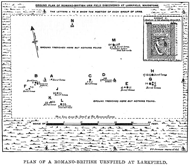
Ground-plan

In recent years it seems that very little has been written about this seemingly lost site, long since destroyed by the self-righteous advance of the Industrialists.  It seems to have been an important place, as there were many cremated remains here in more than a dozen individual burial urns, some with flints deposited in them.  The site was first described in a meeting of members of the Society of Antiquaries in 1898 by a Mr Frederick James.  He talked about the site and some brief digging work around the area, thus:

“The site of the urnfield is on land belonging to Mr William Wigan, of Clare House, East Malling, and it was owing to his kind permission and active cooperation that I was enabled to visit the spot, which is on a small plateau above the River Medway, 350 yards to the southwest of New Hythe church, and between the river and the road leading  from Rochester to Town Malling…

“The immediate neighbourhood…has been from time to time highly productive of archaeological remains dating from the Palaeolithic times and extended down to the Roman occupation… (But at) the Larkfield urnfield, the first indication that was afforded of the uses to which the area had been put in Romano-British times was the accidental discovery, whilst planting fruit trees, of some fragments of pottery (including portion of a Samian patera) found at the point marked A on the plan.  A flat tile was found covering the fragments.”

Much more was found hereby, with the majority of the finds being “a group of urns containing cremated interments found in the urn-pits.”  Although James (1898) described them as dating from the Romano-British period, from his description and illustrations it would seem that the remains here were probably of an earlier date, perhaps Iron- or even Bronze Age.  But we may never know for sure.

Reference:

  1. James, Frederick, “Discovery of a Romano-British Urnfield at Larkfield, near Maidstone,” in Proceedings of the Society of Antiquaries, 17:1, 1898.

© Paul Bennett, The Northern Antiquarian 


Bleara Moor Cairnfield, Earby, Lancashire

Cairns:  OS Grid Reference – SD 919 457

Getting Here

From Earby, go eastwards up the steep moorland Coolham Lane. A coupla hundred yards up past the little reservoirs on your right there’s a tall, large wooden stile to climb over, up the old heaps of quarried stone and onto the flat moorland plain of Bleara Moor.  You’re here! If the heather’s grown back however, you’ve no chance of seeing ’em!

Archaeology & History

One of at least a dozen small cairns on NW of Bleara Moor

When we came up here the other day (ostensibly to check out the great Bleara Lowe tombs on top of the moor), a grey wet day scattered its more darkened light across the moor, which thankfully had been burnt back a few months previous. If this hadn’t happened, we’d have never seen what we found: a scattering of at least a dozen small single cairns, typical of those found on the upper and lower slopes of Green Crag Slack on Ilkley Moor.  They’re on the lower northwest-facing plain of Bleara Moor and all are roughly the same size: about 3 yards by 3 yards across and only a foot or two in height, much overgrown in peat and vegetation.  Although we found a good number of these small cairns where the heather had been burnt away, there also seemed to be others in the long heather itself, but this was, of course, hard to say with any certainty.  A few more exploratory ventures in and around the moor would be good after the next heather-burning sessions!

© Paul Bennett, The Northern Antiquarian

Pike Hill, Stamfordham, Northumbria

Cup-and-Ring Stone:  OS Grid Reference – NZ 0774 7048

Archaeology & History

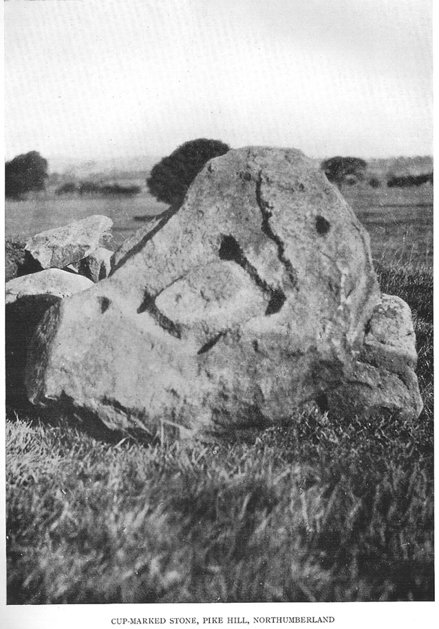
1928 photo of carving

Found inside a prehistoric tomb that was excavated in the late 1920s “by Messrs R.C. and W.P. Hedley at Pike Hill, near Stamfordham,” this fascinating-looking carving was found on a stone that “was overlying the primary burial” cist in the middle of the tumulus, measuring “2 feet 9 inches long by 2 feet wide and 12 inches deep, with an orientation on the longer axis of NE.”  As we can see in the old photo that accompanied Mr Hedley’s (1928) short article in Antiquity journal, four single cups are arranged in a rough square and are joined with each other by a single line, running from cup to cup, outlining a clear quadrilateral formation.  Two other single cups are outliers on the left and right side of the ‘square.’

A second smaller cist was also found inside the same mound and on the central inner face of this was another, more simplistic carving described as “a very fine cup-mark 1½ inch in diameter and ¾-inch deep.”  These carvings are no longer in situ (I think they’re in Newcastle Museum) and apparently this second single cup-marked stone can no longer be located.

References:

  1. Beckensall, Stan, Northumberland’s Prehistoric Rock Carvings, Pendulum: Rothbury 1983.
  2. Beckensall, Stan, Prehistoric Rock Motifs of Northumberland – volume 2: Beanley to the Tyne, Abbey Press: Hexham 1992.
  3. Hedley, R. Cecil, “Ancient British Burials, Northumberland,” in Antiquity Journal, volume 2, December 1928.

© Paul Bennett, The Northern Antiquarian


North Hill, Samson, Scilly Isles, Cornwall

Chambered Cairn:  OS Grid Reference – SV 877 131

Archaeology & History

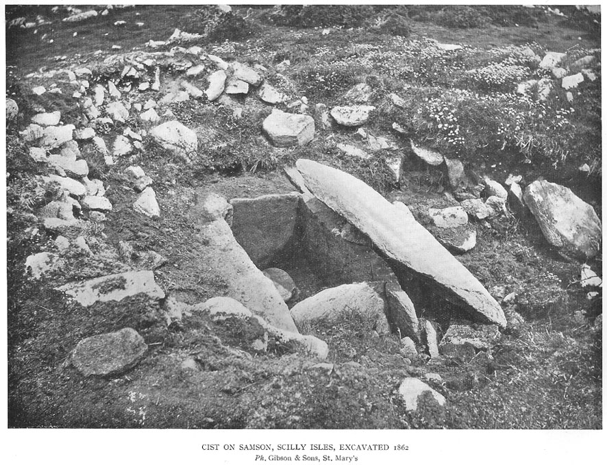
Early photo of the North Hill tomb (Crawford 1928)

On the north side of Samson island there are several chambered tombs and cairns scattered around the edges of aptly-named North Hill; but the one illustrated here was one of the first to be excavated in 1862-3.  Although O.G.S. Crawford (1928) wrote about the site in his essay on Cornish cists — from where this old black-and-white photo of the site has been taken — it was described in much greater detail in Borlase’s (1872) archaeological magnum opus of the day.  In his time, this now much-denuded burial site had all the outer hallmarks of being a large tumulus.  This was described in some detail in a paper written by one Mr Augustus Smith (read at a Meeting of the Royal Institution of Cornwall in May, 1863) who was fortunate enough to be one of the first people to unearth this great tomb and find the site untouched since it had been laid, thousands of years earlier.  Citing extensively from Smith’s notes, Borlase told:

“The Barrow…is situated with four or five others, mostly rifled on the…high ground at the northern end.  “The mound, in its outer circumference, measured about 58 feet, giving, therefore, a distance of near upon 30 feet to its centre, from where the excavation was commenced.  For about 18 or 20 feet the mound appeared entirely composed of fine earth, when an inner covering, first of smaller and then or large rugged stones, was revealed.  These were carefully uncovered before being disturbed, and were then one by one displaced till a large upright stone was reached, covered by another of still more ponderous dimensions, which projected partially over the edges of the other.  At length this top covering, of irregular shape, but measuring about 5 feet 6 inches in its largest diameter, was thoroughly cleared of the superincumbent stones and earth, and showed itself evidently to be the lid to some mysterious vault or chamber beneath.”  On the lid being removed, there was “disclosed to view an oblong stone chest or sarcophagus beneath” on the floor of which, “in a small patch,” “a little heap of bones, the fragmentary framework of some denizen of earth, perhaps a former proprietor of the Islands—were discovered piled together in one corner.

“”The bones were carefully taken out, and the more prominent fragments, on subsequent examination by a medical gentleman, were found to give the following particulars: – Part of an upper jawbone presented the alveolæ of all the incisors, the canines, two cuspids and three molars, and the roots of two teeth, very white, still remaining in the sockets.  Another fragment gave part of the lower jaw with similar remains of teeth in the sockets.  All the bones had been under the action of fire and must have been carefully collected together after the burning of the body.  They are considered to have belonged to a man about 50 years of age…

“”The bottom of the sarcophagus was neatly fitted with a pavement of three flat but irregular-shaped stones, the joints fitted with clay mortar, as were also the insterstices where the stones forming the upright sides joined together, as also the lid, which was very neatly and closely fitted down with this same plaster.

“”Two long slabs, from seven to nine feet in length, and two feet in depth, form the sides, while the short stones fitted in between them make the ends, being about 3½ feet apart, and to fix which firmly in their places, grooves had been roughly worked in the larger stones.”  The paving stones had been “embedded immediately upon the natural surface of the granite of which the hill consists.”

References:

  1. Borlase, William Copeland, Nænia Cornubiæ, Longmans Green: London 1872.
  2. Crawford, O.G.S., “Stone Cists,” in Antiquity Journal, volume 2, no.8, December 1928.

© Paul Bennett, The Northern Antiquarian

High Marchup, Silsden, West Yorkshire

Tumulus:  OS Grid Reference – SE 0501 4949

Also Known as:

  1. Parson’s Lane Tumulus

Getting Here

High Marchup tumulus

From Silsden go up the long hill (A6034) towards Addingham until the hill levels out, then turn left on Cringles Lane (keep your eyes peeled!) for about 500 yards until you reach the Millenium Way footpath, or rather, green lane track, to your right.  Walk along this usually boggy old road for another 400 yards until you’re level with the small copse of trees below the field (about 100 yards away).  The slightly raised ditched mound on the left side of the track ahead of you is what you’re after!

Archaeology & History

Unless this old tomb was pointed out, you probably wouldn’t give the place a second glance.  It’s a seemingly isolated singular round tomb, subsided on top and surrounded by a small ditch, running into the edge of the walling.  Gorse bushes and a few rocks are around the edges of the site.  Harry Speight (1900) described this old tomb as a

“lonely isolated mound, to be seen in Parson Lane about a hundred yards west of the Celtic boundary, Black Beck, where some old dying chief has called his friends around him bidding them, “heap the stones of his renown that they may speak to other years.”  It is a tumulus 80 feet in circumference and does not seem to have been disturbed.”

In Faull and Moorhouse’s (1981) magnum opus they describe the site as “the denuded remains of a ditched round barrow,” but say little else.  It may have had some relationship with the settlement remains in and around the huge Counter Hill complex, immediately north.

References:

  1. Cowling, E.T., Rombald’s Way: A Prehistory of Mid-Wharfedale, William Walker: Otley 1946.
  2. Faull, M.L. & Moorhouse, S.A. (eds.), West Yorkshire: An Archaeological Guide to AD 1500 (4 volumes), WYMCC: Wakefield 1981.
  3. Speight, Harry, Upper Wharfedale, Elliott Stock: London 1900.

© Paul Bennett, The Northern Antiquarian

Leathad Carnaich, Dalhalvaig, Caithness

Cairn:  OS Grid Reference – NC 89044 55882

Archaeology & History

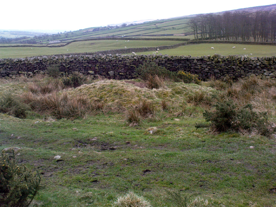
An unexcavated ring cairn in a very good state of preservation can be seen in the field immediately west of the River Halladale.  Measuring more than 14 yards across east-west and 15 yards north-south, the site stands in association with several other unexcavated cairns.

Folklore

Although some of the cairns here have been found with prehistoric burials in them, tradition tells that the cairns here were the result of “a great battle between the native Pictish inhabitants and the invading Norsemen.” So wrote George Sutherland, many moons ago. He continued:

“The Norsemen were defeated in that battle, and Halladha, their leader, was slain. It is from him that the river and the dale take their name. The battle was fought on a hillside, on the east side of the river and that hillside is covered with cairns which are supposed to mark the graves of those slain in this battle, but the body of Halladha, the norse leader, was interred on the west side of the river, and his sword was laid in the grave beside his body. Near the circular trench where he is said to have been buried there are several heaps of stones which are supposed to mark the graves of other Norsemen of note who fell in the battle.”

References:

  1. Sutherland, G., Folklore Gleanings and Character Sketches from the Far North, John o’ Groats Journal: Wick 1937.

© Paul Bennett, The Northern Antiquarian


Mill Hill, Eastburn, Driffield, East Yorkshire

Tumulus:  OS Grid Reference – SE 986 553

Also Known as:

  1. Barrow no.268 (Mortimer)

Archaeology & History

Once located on the south side of the stream between the ‘lost’ village of Eastburn and the cottages at Battleburn, this burial mound was one of many explored by the great J.R. Mortimer (1905), who told that:

“On June 24th, 1884, it measured about 40 feet in diameter and 4½ in elevation, and had a depression in the centre, which might have been caused by a former opening.  By the old inhabitants of the neighbourhood it is known — like several other similar mounds near settlements — by the name of Mill Hill.  A 15-feet square was cut from the centre and the natural ground beneath was found to consist of 3 feet of clay, resting upon chalk gravel.  Through this clay and into the chalk gravel beneath was a roughly-cut trench, 3½ feet deep by about 3 feet wide, running north and south the whole width of our excavation and beyond, and from about the centre of the mound a similarly roughly-formed trench was observed to run east and west…”

In the sections that Mortimer and his fellows excavated, they uncovered various intriguing deposits, including the remains of ox, goats and horses.  Later deposits were also located in and around the mound, showing it had been used in more recent centuries.

Folklore

Mortimer suggested this site was once an old moot site; comparing it to a place of the same name a short distance west at Kirkburn.

References:

  1. Mortimer, J.R., Forty Years Researches in British and Saxon Burial Mounds of East Yorkshire, A. Brown & Sons: London 1905.

© Paul Bennett, The Northern Antiquarian

Overton Down Tomb, West Overton, Wiltshire

Cairn:  OS Grid Reference – SU 1305 7052

Getting Here

Overton Down cairn (image © Pete Glastonbury*)

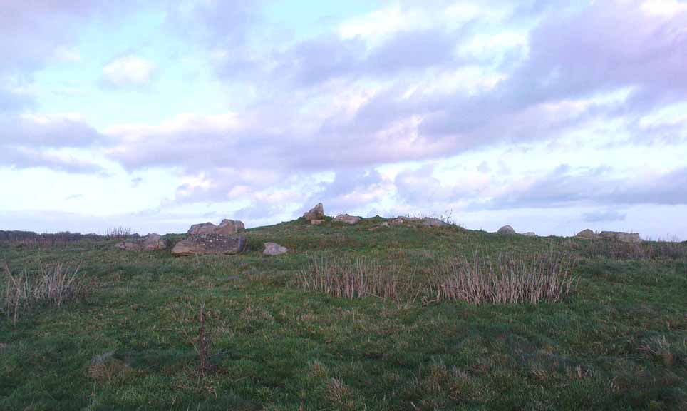
From the Avebury stone circle, walk out eastwards and straight up the ancient Ridgeway for about a mile until it levels out and meets up with the adjoining track upon the hilltop. Instead of going left or right, go straight across and onto the footpath that crosses Overton Down, until you reach the wide horse-racing track lookalike called ‘the Gallops.’  Stop – don’t go on it – and follow the fence down for a coupla hundred yards till you’ll see the fenced-off rise with a modern ‘barrow’ enclosed within. You’re very close! From here, go another 100 yards or so down and keep your eyes on the rise of land with rocks scattered around it.  That’s it!

Archaeology & History

From all accounts, there’s been nowt of any consequence written about this site — which is bloody incredible to be honest!!  We came here on a fine day (that’s Mikki, Geoff and June) in the company of the local Avebury magus, Pete Glastonbury.  Crossing Overton Down towards an experimental “barrow” that some archaeo’s have knocked-up, the rise in the land here stands out quite clearly, saying (at the very least), “look at me!”  But until Pete Fowler (2000) first described this “unrecorded kerbed round barrow” a few years back, it had escaped the noses of all previous archaeological surveys!  How!?

What the hell do archaeologists in the Avebury area do with themselves if they can’t pick this sorta monument out!?  But anyway…

Overton Down cairn – looking NW

This is quite a large rounded cairn structure by the look of it.  At least 30-feet across, probably kerbed from the initial look (only for a few minutes, sadly).  Local writer Terence Meaden has apparently found the site of some importance in his studies (not yet published).  Its position here in the landscape was what caught my attention more than anything: it stands on the crest of the hill and has superb uninterrupted views far across the Avebury landscape.  This siting was obviously quite deliberate. Less than 100 yards due north of here are two curiously placed stones which may ‘frame’ the cairn for a southern lunar alignment.  I had no time to look at this really, so it would be good if some local Avebury dood could check this out.  The outlying stones may be merely fortuitous, but it’d be good to know for sure!

The site has been plotted amidst a mass of landscape changes dating from the neolithic to medieval periods.  It seems probable, on first impression, that the ‘cairn’ is of Bronze Age in character (though could be earlier), but until detailed analysis has been made we obviously won’t know for sure. A short distance to the south we have the much-denuded Overton Down site X1: another Bronze Age burial that yielded three beaker graves when Fowler excavated the place in the 1960s.

For those of you into geomancy, meditation and the subjective realms of genius loci, this one really grabbed me.  Give it a go and lemme know what you get.  But please, no stupid pagan or New Age offerings — the site doesn’t need that sorta thing.

References:

  1. Fowler, Peter, Landscape Plotted and Pierced: Landscape History and Local Archaeology in Fyfield and Overton, Wiltshire, Society of Antiquaries: London 2000.

* Pete Glastonbury is a Wiltshire-based photographer specialising in Landscapes, Astronomy, Archaeology, Infra-Red, Experimental Digital Photography and High Dynamic Range Panoramic photography.

© Paul Bennett, The Northern Antiquarian


Barrow Field, Bushy Park, Teddington, Middlesex

Tumulus (destroyed):  OS Grid Reference – TQ 163 703

Archaeology & History

This is one of very few prehistoric tombs that are known about from the London region and — surprise, surprise! — very little is left of the place.  No surprise really.  It appears to have first been explored soon after Queen Victoria came to the throne

“A barrow on the south side of Sandy Lane was excavated in 1854.  It revealed some much disturbed burials, some flint tools and part of a bronze dagger.” (Ching & Howe 1980)

There were in fact the remains of three people found here: one at base level; the other just below the top; and the third body comprised remains that appear to have been buried just beneath the surface.  The tomb was a big thing aswell — being nearly 100 feet across and more than 10 feet high.  Pity there’s little to be seen of it today…

References:

  1. Ching, Paddy & Howe, Ken, Teddington – As it Was, Hendon: Nelson 1980.
  2. Gordon, E.O., Prehistoric London – Its Mounds and Circles, Covenant: London 1946.
  3. Merriman, Nicholas, Prehistoric London, London Museum 1990.
  4. Spence, Lewis, Legendary London, Hale: London 1937.

© Paul Bennett, The Northern Antiquarian