Lexden Tumulus, Colchester, Essex

Tumulus:  OS Grid Reference – TL 975 247

Getting Here

Fortunately for the person who lives here, this much overgrown and denuded remains of a fabled tumulus is in their garden!  The mound is divided by a hedge in the back garden, up near the bend of where Fitzwalter Road meets St. Clare Road and the school field backs onto them.  I’ve no idea whether the people who own the gardens are OK with you visiting the site or not. If you wanna look at it, I s’ppose the only thing to do is knock on their door and ask!

Archaeology & History
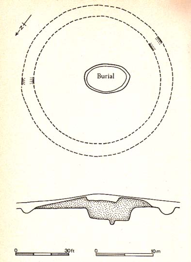
Plan of the Lexden tumulus (Laver, Archaeologia 1927)

Ascribed as late Iron Age, some of the finds here are distinctly Romano-British.  Indeed, excavations here by P.G. Laver in 1924 uncovered rich Belgic remains akin to the chariot burials found in East Yorkshire! (though not quite as good as them)  There was a considerable collection of gold, silver and other metalwork remains here, along with considerable remains of pottery aswell.  It seems there was a tradition of burials here, with some evidence dating from the Bronze Age — but the majority of remains found in the excavations were from the much later period.  One account attributes the burial mound to have held the body of Cunobelin; the other, the body of Addedomaros of the Trinovante tribe.

Folklore

Quoting from an earlier source (A.H. Verrill’s Secret Treasure, 1931), in Leslie Grinsell’s (1936) fine early survey on British prehistoric tombs, he described the legend of there being hidden treasure here, saying that locally there was

“a belief that it was the burial place of a king in golden armour, with weapons and a gold table.”

But was this legend described anywhere before P.G. Laver’s excavation of the site in 1924…?  It would be very intriguing if we could find this out!

References:

  1. Grinsell, Leslie V., Ancient Burial Mounds of England, Methuen: London 1936.
  2. Laver, P.G., ‘The excavation of a Tumulus at Lexden, Colchester,’ in Archaeologia journal, no.76, 1927.

Links:

  1. Unlocking Essex’s Past: The Lexden Tumulus & Associated Cemetery

© Paul Bennett, The Northern Antiquarian

Acrehowe Circle, Baildon Moor, West Yorkshire

Ring Cairn:  OS Grid Reference – SE 14245 40686

Also Known as:

  1. Coll’s Burial Mound
  2. Rerehowe

Getting Here

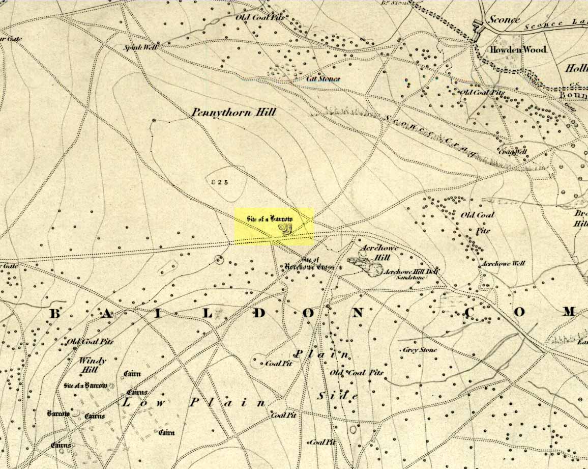
Acrehowe site on 1852 map

Go up through Baildon centre and head onto the moors. Crossing the cattle-grid, a coupla hundred yards further up, turn left. Past the small reservoirs on your left, another 100 yards or so and you reach the brow of the hill.  As you begin going down the road, there’s a small car-park right by the roadside.  The curious remains of the earthworks at the side of the old circle are discernible in the grassland right to its side.

Archaeology & History

Illustrated on the 6-inch OS-map of 1852 as “Site of a Barrow” (similar to how it appears in the image drawn here by Mr. C.N.M. Colls) a short distance below Pennythorn Hill top, there are still considerable traces of the earthworks surrounding the east and southern sides of what was once some form of ring cairn or tumulus that was once at this prominent place in the landscape.

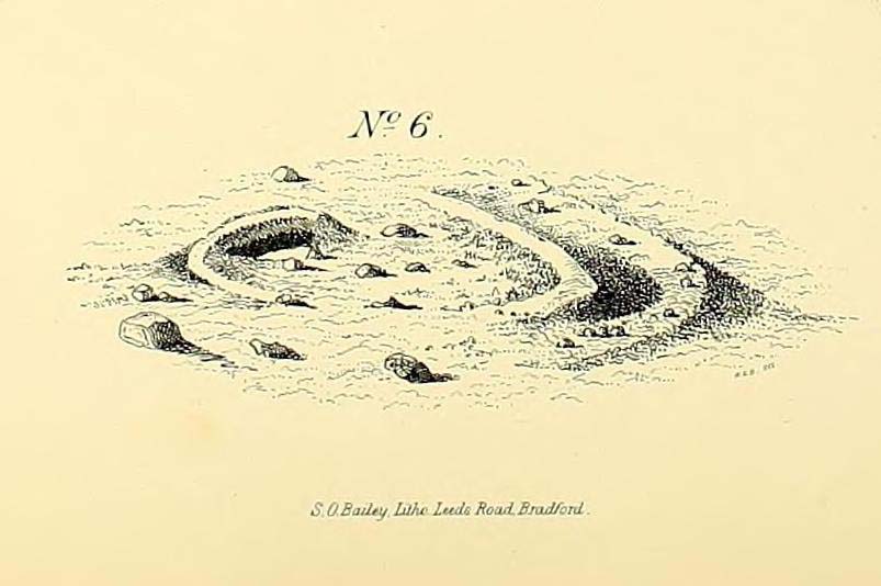
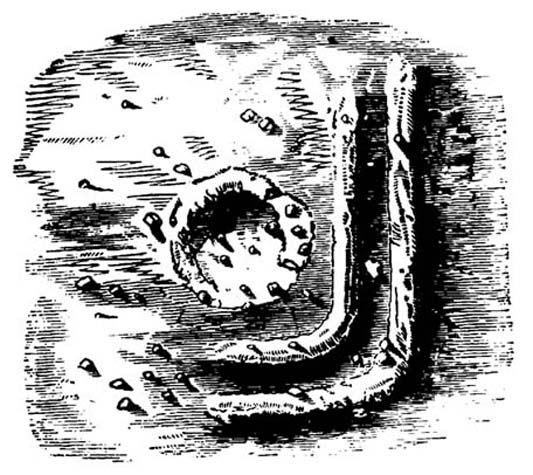
Aerial view of siteThe site was first explored by Mr Colls in 1843 (his results were reported a few years later), who found a loose double-ring of stones, fifty feet across, surrounded by a shallow trench which was most notable on the south and east sides. Two urns were also uncovered near the centre of the ring, nearly two feet down, containing the cremated remains of people.  A few years later, the Leeds historian James Wardell (1869) told a most fascinating note about what happened during their excavation, saying:

“This…examination was attended by a circumstance not soon to be forgotten by the persons engaged therein (on the excavation). They had almost reached the place where the broken urn and bones were deposited when, at once, such a fearful storm of thunder, lightning and rain came on, that they were not only considerably alarmed, but driven from the Common to seek shelter in the village.”

Colls’ 1846 sketch

We hear this sorta thing at many of our ancient places!

Colls 1846 plan

One anonymous writer in 1955 described the site as a ‘stone circle’, and a number of subsequent archaeologists copied this without question; but in all probability this site was more typical of an old cairn circle or ring-cairn, similar in size and design to the Roms Law circle two miles north of here.  However, the earthworks at its side give the impression of some sort of exaggerated hengiform enclosure.

The place-name element howe strongly indicates a burial site and is a suffix found at many prehistoric tombs across northern England.  The prefix ‘acre’ may relate to “a plot of arable or cultivated land, a measure of land (an acre) which a yoke of oxen could plough in a day” (Smith 1956), or may be a corrupted form of the Old English word, ‘acen’, relating to oak trees.  Early literary examples of the place-name would enable a clearer understanding of the prefix element here.

References:

  1. Anonymous, Colls’ Burial Mound Stone Circle, Baildon Moor, Museum Leaflets: Bradford 1955.
  2. Baildon, W. Paley, Baildon and the Baildons (parts 1-15), St. Catherines: Adelphi 1913-26.
  3. Barnes, Bernard, Man and the Changing Landscape, Eaton: Merseyside 1982.
  4. Bennett, Paul, The Old Stones of Elmet, Capall Bann: Milverton 2001.
  5. Colls, J.N.M., ‘Letter upon some Early Remains Discovered in Yorkshire,’ in Archaeologia, 31, 1846.
  6. Collyer, Robert & Turner, J.H., Ilkley: Ancient and Modern, William Walker: Otley 1885.
  7. Smith, A.H., English Place-Name Elements – volume 1, Cambridge University Press 1956.
  8. Wardell, James, Historical Notes of Ilkley, Rombald’s Moor, Baildon Common, and other Matters of the British and Roman Periods, Joseph Dodgson: Leeds 1869. (2nd edition 1881)

© Paul Bennett, The Northern Antiquarian

Frensham Common necropolis, Frensham, Surrey

Tumuli:  OS Grid Reference – SU 853 406

Archaeology & History

There are several tumuli near the top of the hill here, but only one of them really stands out.  Nick Thomas (1976) told it to be one “of the best preserved bowl barrows in Surrey.”  A brief description of the relevant tombs, running north to south:

“the first is 75ft across and 6ft high; the second, which has a surrounding ditch 9ft wide, is also 75ft across, but is 8ft high.  The third has a diameter of 42ft and a height of 4ft.  The last is 54ft wide and 5½ft high.  It has a surrounding ditch 8ft wide. ” (Thomas 1976)

None of the tombs had been excavated up to the early 1980s, but I’m not sure if anything has been found since then.  There was also a potential “great stone” up here that was mentioned by John Aubrey in the late 17th century, but nothing has been seen of it since.  In all probability this was a standing stone or the remains of some prehistoric tomb.

Folklore

Several hundred years ago the King’s antiquary, John Aubrey, told the curious tale of the great cauldron that was said to have been found here:

“In the vestry (of Frensham church, in Surrey), on the north side of the chancel, is an extraordinary great kettle or caldron, which the inhabitants say, by tradition, was brought hither by the fairies, time out of mind, from Borough-Hill, about a mile hence. To this place, if anyone went to borrow a yoke of oxen, money, etc., he might have it for a year or longer, so he kept his word to return it. There is a cave where some have fancied to hear music.  On this Borough hill…is a great stone lying along, of the length of about six feet. They went to this stone and knocked at it, and declared what they could borrow, and when they would repay, and a voice would answer when they should come, and that they should find what they desired to borrow at that stone. This caldron, with the trivet, was borrowed here after the manner aforesaid, and not return’d according to promise; and though the caldron was afterwards carried to the stone, it could not be received, and ever since that time no borrowing there.”

In relation to the folklore that is generally attached to the tumulus on top of the hill here from which modern lore ascribes the cauldron to have originated, when A.G. Wade (1928) came to investigate the nature of the site and the folktale he found that,

“there are several folk-tales other than those given by Aubrey.  One relates that it was dug up on Kettlebury Hill, south of Hankley Common, by the monks of Waverley Abbey, and that it was taken by them to Frensham for brewing ale.  Another tale says that it was a loan from the fairies of Thursley — there are tumuli in this parish, south of Ockley Common — and that Mother Ludlam, a medieval witch who lived, according to tradition, in Ludlam’s Cave in Moor Park, was the owner and lender.  The cave was dug by a monk of Waverley Abbey who, when the water supply of the Abbey failed, found that three springs joined here, and by enlarging their outlets and bringing them together he obtained a good supply of fresh drinking water…”

Mr Wade was also unable to satisfactorily show that the Borough Hill named in Aubrey’s survey and Frensham Common hilltop were one and the same.

References:

  1. Aubrey, John, The Natural History and Antiquities of Surrey, E. Curll: London 1719.
  2. Thomas, Nicholas, Guide to Prehistoric England, Batsford: London 1976.
  3. Wade, A.G., “The Great Cauldron of Frensham,” in Antiquity, 2:6, June 1928.

© Paul Bennett, The Northern Antiquarian

Oliver Cromwell’s Hill, Eye, Cambridgeshire

Tumulus (destroyed):  OS Grid Reference – TF 232 018

Archaeology & History

Very little was known about this now lost burial mound.  It was one of several nearby but, thankfully, the local historian and archaeologist E. Thurnam Leeds (who once lived at the nearby Eyebury Farm) sent a letter to the Society of Antiquaries in London, describing some pottery and other remains that he’d found there:

“The small pot of a late Bronze Age type and the other sherds exhibited were found in a tumulus known as Oliver Cromwell’s Hill, at Eyebury, near Peterborough.  As only a portion of the tumulus has been examined as yet, it is proposed to defer a full account of the excavations until further progres has been made.  The tumulus is of the round type, about 40 yards in diameter and 5 feet high at the centre.  On three sides traces of a ditch were met with, containing soil which had evidently been burnt.  Close to the gravel in the centre of the tumulus there were two distinct layers of charcoal, and in two places apparently remains of hearths.  The small pot was found only 1½ feet down on the south-eastern side of the mound, 39 feet from the centre.  In the centre itself at various depths were found sherds, some of Bronze Age forms; but a pice of a rimmed vase found at a depth of 3 feet 6 inches, about 6 inches above the first charcoal layer, appears to be of Roman date, in which case the centre of the tumulus must have been disturbed in those times, though the charcoal floors were never pierced.  Bones of various animals, including sheep, pig, dog and hare, and a large flint flake were also found.”

As far as I’m aware, no further detailed examinations took place at this curiously-named hillock, whose folktale I’ve yet to read.

References:

  1. Leeds, E.T., ‘Letter,’ in Proceedings of the Society of Antiquaries, 22:1, 1910.

© Paul Bennett, The Northern Antiquarian


Fairy Knowe, Crarae, Minard, Argyll

Cairn:  OS Grid Reference – NR 9874 9736

Also Known as:

  1. Canmore ID 40010

Archaeology & History

Fairy Knowe (Campbell 1923)

Just over 100 yards northeast of the chambered cairn in Crarae Garden we can see the denuded remains of this old mound, long ago held as the dwelling place of the little people. When it was first described in 1865, a standing stone was reported as surmounting the tomb, but this can no longer be seen.  Further excavations made by Sir George Campbell in 1923 and reported in the Oban Times, showed the cairn to have been 108 feet across and nearly 6 feet tall at the centre — beneath which a “stone coffin” was found.  It was said that two passages ran from this middle chamber: one to the southwest and the other roughly southeast.  Deposits of shells, antlers, and the bones of cattle, deer, horses and sheep were also found here.

References:

  1. Royal Commission on the Ancient & Historical Monuments, Scotland, Argyll – volume 6: Mid-Argyll and Cowal, HMSO: Edinburgh 1988:61.
  2. Scott, J.G., “Excavation of the Chambered Cairn at Crarae, Loch Fyneside,” in Proceedings of the Society of Antiquaries, Scotland, volume 94, 1961.

Links:

  1. The Fairy Knowe, Crarae – on Scotland’s Places

© Paul Bennett, The Northern Antiquarian


Torrisholme Barrow, Morecambe, Lancashire

Tumulus:  OS Grid Reference – SD 4596 6425

Getting Here

Various ways up this old hill, visible from all angles it seems.  I came up via the housing estate near where us friend lives, near Bare Lane Station, through the houses and up the footpath.  But you can just as easy (if not easier) walk up from the country lane and fields beneath its eastern side.  Much nicer!

Archaeology & History

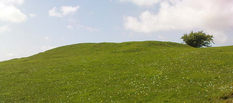
Torrisholme Barrow
Torrisholme Barrow

As many northerners will tell: gerrin information from the Lancashire archaeologists about prehistoric sites is troublesome (must be Southerners running the show!).  There’s tons of stuff in this good county, but archaeo-info is pretty poor on the ground.  This great old tomb for example, is designated as a “round barrow” on the Lancashire County Council monuments and records listing, but there’s no other info telling when it was dug, who by, the size of the tomb, what was found here, etc.  Pretty poor to be honest (c’mon chaps – get yer fingers out!).  The best info on-line comes from the more dedicated amateur enthusiasts.

A local historian told us that there was nowt up here, but my nose told me otherwise — so up we tramped!  It was pretty obvious once we’d got to the top here, that some ancient mound had been built up.

“This has all the hallmarks of a tomb,” I said.

Torrisholme Barrow, looking SW

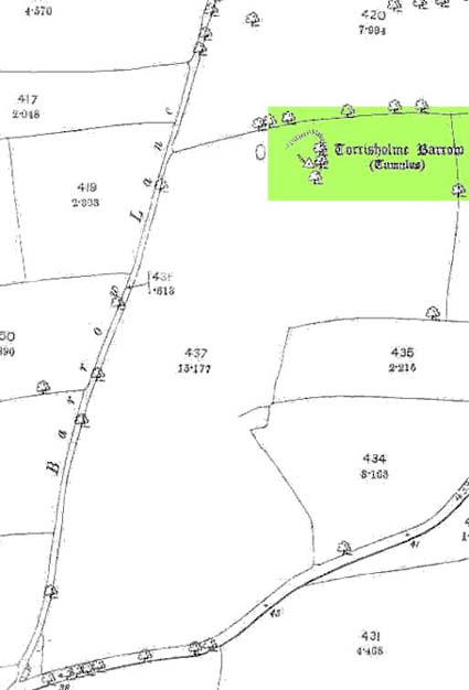
The spirit of the ancestor herein (whoever s/he was) had excellent views and flights to numerous important hills 360° all round here.  A perfect place for a tomb! And when we returned into the Darklands of our Yorkshire abodes, we found this notion to be true.  Marked on early OS-maps as a tumulus, next to the tell-tale giveaway route of Barrow Lane, there are passing mentions of it in a couple of old local history books I’ve come across, but I’ve yet to find much more about it.  It’s a fine mound and of decent size, well worth checking out if you’re in the area.  Once I get more details of the archaeological finds from here, I’ll add the data to TNA (but based on past performances and responses from Lancashire archaeo’s, I wouldn’t hold your breath…)

And for any Morecambe historians who might be able to find more: what — if anything — is known of the ‘Fartle Barrow’, now swallowed by the encroachment of the sea, just a few hundred yards west of here?

Early OS-map showing barrow

Folklore

In days of olde, this site was an old moot or meeting hill: one of the northern Law or council meeting hills.  Quite how far back this gathering tradition up here goes, aint known.  We do know however that there was a christian tradition enacted here, at Easter, of local church doods taking a cross up the top of the hill (does anyone know the story behind the old Cross Hill, half-a-mile south of here?).  There’s obviously quite a lot more pre-christian activities occurrent round here than has been previously thought.

© Paul Bennett, The Northern Antiquarian

Douglas Terrace, Cambusbarron, Stirlingshire

Cairn (destroyed):  OS Grid Reference – NS 782 929

Archaeology & History

At the bottom of the ridge from the (supposedly) singular King’s Park cup-and-ring stone,” in a sand-pit adjoining Douglas Terrace,” we could once find the remains of a now lost prehistoric tomb.  First described in the Stirling Natural History Society’s Transactions in 1907, the Scottish Royal Commission lads (1963) told us that, “an urn from this cist was taken to the Smith Institue, Stirling, in a broken condition.” Anymore information about this site, or images of the fragmented urn, would be hugely appreciated.

It does seem very probable that the King’s Park cup-and-ring stone at the top of the ridge from here did relate to local neolithic or Bronze Age burial sites, as I suspected.  It’s highly likely that other carvings were (are?) hidden beneath, or round the edges of this Douglas Terrace and Kings Park region, as I suggested a few months ago.  It’s imperative that archaeologists in the district pay attention to this area before giving the go-ahead of any further landscape destruction.

References:

  1. Royal Commission on Ancient & Historical Monuments, Scotland, Stirlingshire – volume 1, HMSO: Edinburgh 1963.

© Paul Bennett, The Northern Antiquarian

Birkhill House, Cambusbarron, Stirlingshire

Cairns (destroyed):  OS Grid Reference – NS 780 926

Archaeology & History

In times past, there were at least two prehistoric tombs in land either side of old Birkhill House, now covered by the M9 motorway.  The Scottish Royal Commission lads described the first as being “in the garden of Birkhill House,” continuing:

“This cist contained bones and an urn which measured 5in in height and 6in in diameter, and was ornamented with zigzag lines.”

They think, from its description, that “it may have been a food vessel.”  There were also the remains of another tomb to be found in “rising ground to the west side of” Birkhill House.  Both of these finds were first described in the local Transactions of the Stirling Natural History and Antiquarian Society in 1880.  It seems that little else is known about them. (Thanx again to Paddybhoy for prodding my attention here.)

References:

  1. Royal Commission on Ancient & Historical Monuments, Scotland, Stirlingshire – volume 1, HMSO: Edinburgh 1963.

© Paul Bennett, The Northern Antiquarian


Coneypark Nursery, Cambusbarron, Stirlingshire

Cairns (destroyed):  OS Grid Reference – NS 783 926

Archaeology & History

At least two old tombs that could once be seen here are long-gone by all accounts.  They could be found 200 yards south of the remaining King’s Park cup-and-ring stone.  The first was described by the Royal Commission lads (1963) as a well-defined cist, “situated within a gravel mound and (it) contained a skeleton.”  Another tomb site was described a few years later:

“A second short cist was found just within the cairn material 3m SE x E from cist no.1.  It consisted of a capstone set on built-up side walls, the bottom courses being five slabs on edge.  The internal measurements were 64cm long and 48cm wide and 60cm deep.  This second cist was orientied NE-SW with its floor made of small pebbles on which lay a late incised beaker and a small piece of human skull.”

References:

  1. Royal Commission on Ancient & Historical Monuments, Scotland, Stirlingshire – volume 1, HMSO: Edinburgh 1963.
  2. Thompson, J.K., “Coneypark: Bronze Age Cairn,” in Discovery & Excavation in Scotland, 1972.

© Paul Bennett, The Northern Antiquarian


Cnoc a’ Chuirn Mhoir, Jura, Argyll

Cairn:  OS Grid Reference – NR 68298 94211

Archaeology & History

This ‘hill of the big cairn’ is near the top end of the island, past the cup-marked stones of An Carn, just beneath the top of the prominent knoll, a half-mile east of the track.  It’s about 200 yards from the summit on the southern side of the hill.  More than 50 feet across and about 3 feet high, what may be kerb-stones can be seen on the west-side of the tomb.  The Royal Commission (1984) lads tell us that,

“its northern edge is buried under field-gathered stones, and a small enclosure of comparatively recent date overlies the cairn.”

References:

  1. Royal Commission on the Ancient & Historical Monuments of Scotland, Argyll: volume 5 – Islay, Jura, Colonsay and Oronsay, HMSO: Edinburgh 1984.

© Paul Bennett, The Northern Antiquarian