Ford, Kilmartin, Argyll

Tumulus:  OS Grid Reference – NM 86899 03572

Getting Here

Ford Tumulus on 1875 map

Although I describe this site in association with the township of Kilmartin, it is in fact several miles north of there – but I reckoned that if I say it’s near Kilmartin, then those of you who don’t really know this region, will have some idea of its locale.  So – from Lochgilphead, go up north thru Kilmartin, another coupla miles on, till you reach the small road to your right (signposted ‘Ford’).  Just keep driving for a couple more miles until you hit the village.  If you park by the only shop, you’re just past the old tomb.  Diagonally across on the opposite side of the road from the Ford Hotel, right by the road-junction, just before the little shop, you’ll see a notable rounded mound overgrown in shrubs. Embedded in this are the remains of an old tomb.

Archaeology & History

Ford tumulus (photo, couresty J. Reid)

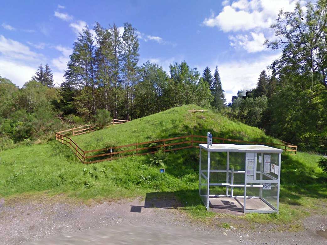
This typical-looking fairy-mound just by the road junction in the village is where me and my daughter used to scramble around, sometimes playing and sometimes seeing if we could find anything of note in this ancient hillock, but all trace of any prehistoric stonework seems to be well-buried.  When excavators explored the site in bygone times, a small stone cist was found, which aligned (yet again) north-south and measured internally, roughly, 3ft x 2ft.  Only small!

A food vessel in Edinburgh’s central museum, “found in a cist in the neighbourhood of the lower end of Loch Awe” is thought to have come from this tomb.

References:

  1. Royal Commission on the Ancient & Historical Monuments of Scotland, Argyll – volume 6: Mid-Argyll and Cowal, HMSO 1988.

© Paul Bennett, The Northern Antiquarian


Hartwith Moor, Summerbridge, North Yorkshire

Standing Stone:  OS Grid Reference – SE 21233 62737

Also Known as:

  1. Standing Stone Hill

Getting Here

Hartwith Moor stone

A half-mile south of the superb Brimham Rocks complex, take the straight road south until you hit the second farmhouse (and accompanying caravans).  Go up the public footpath past Highfield Farm and just check with the landowner’s permission to wander his land if you want to see the stone.  They’re OK about it if you ask.  The lady there is very amiable and will tell you what’s what, giving directions right to it, telling us it was off the footpath in the middle of one of his fields.

Archaeology & History

Archaeology texts are, once more, silent about this stone (and other monuments in the region), making you wonder just what the hell some of them are paid for!  The stone appears to have given its name to the land upon which it stands which, as the locals tell, “has always been known as standing stone hill.”  And no wonder — it’s a bloody decent standing stone!  On its northern face we find well-eroded lines running down the stone, similar to the weathering found on the Devil’s Arrows a few miles to the east.

Standing Stone Hill stone
Looking south

Although just over 6-feet tall, this is a solid bulky old fella.  But the spot he presently occupies isn’t his original standing place.  He was found knocked over and lying on the ground in the middle of the 20th century, slightly out of position.  But he was thankfully stood back upright by the local land-owners sometime in the 1960s, where he’s been stood ever since.  It must have been one helluva job!  And making it more difficult was the intriguing geological nature of the Earth right beneath this field.  As the lady who now own the land told us,

“When the fields were tilled we found that all of them were easy to turn over, except the one with the stone in it!  There’s virtually no soil of any depth to write home about,” she said.  “It stands on only a few inches of soil and then you hit solid rock right underneath it.  All the other fields are OK – but this one’s the odd one out.”

And before the fields were farmed, just over a hundred years ago, all this land was covered in moorland heather.  Then the land was enclosed, the Earth’s heathland stripped out of existence and turned over to agriculture.  But thankfully the standing stone was left here.  It makes you wonder what else was destroyed when the moorlands were industrialised…

The stone does get a brief mention in Boughey & Vickerman’s (2003) Prehistoric Rock Art of the West Riding, where they mention there being “three possible cups in (a) line on one side” of the standing stone, but these are little more than Nature’s handiwork and nowt else.  There are a couple of other cup-and-rings nearby which are the real thing – but the ‘cups’ on this stone aint man-made.

© Paul Bennett, The Northern Antiquarian


Ellers Wood (614), Washburn Valley, North Yorkshire

Cup-and-Ring Carving:  OS Grid Reference – SE 1895 5099

Ellers Wood carving 614 (after Boughey & Vickerman)

Getting Here

Ellers Wood is at the very northern edge of the beautiful parish of Askwith and has a very particular ambience of its own. The small cluster of at least 5 cup-and-ring stones in this lovely little woodland gives you the impression that they stood out on their own, living here representing the genius loci of this luscious watery vale, all-but-hidden from all but the lucky few.  It’s very likely that there are still more carvings hidden away nearby.

The best way to check them out is simply to walk down past the haunted Dobpark Lodge, where it turns into a footpath and where it crosses the lovely old packhorse bridge at the valley bottom, walk a few hundred yards up the river-side (at the bottom of the fields) until you reach Ellers Wood. Once there, look around.  This one’s on the west side of the main stream, close by where it meets up with another small burn coming down from the western wooded slopes.


Archaeology & History

First sketch of the carving, c.1994

In the same region as the Ellers Wood 618 and other carvings and very close to the river, somehow this heavily cup-marked stone evaded the prying eyes of such notaries as Cowling, Stuart Feather and Sidney Jackson – all of whom ventured to look at the other petroglyphs in Ellers Wood.  But with good fortune, Graeme Chappell and I re-discovered this fine-looking carving in our explorations in 1993-94 and gave it back the attention it truly deserves.

The main feature here is the clustering of cups into sections, as the drawing indicates.  It is listed as “stone 614” in Boughey & Vickerman’s (2003) survey.

References:

  1. Boughey, K.J.S. & Vickerman, E.A., Prehistoric Rock Art of the West Riding, WYAS: Exeter 2003.
  2. Cowling, E.T., ‘A Classification of West Yorkshire Cup and Ring Stones,’ in Yorks. Arch. Journal 1940.
  3. Cowling, Eric T., Rombald’s Way, William Walker: Otley 1946.
  4. Cowling, E.T. & Hartley, C.A., ‘Cup and Ring Markings to the North of Otley,’ in Yorks. Arch. Journal 33, 1937.
  5. Grainge, William, The History and Topography of the Forest of Knareborough, J.R. Smith: London 1871.
  6. Grainge, William, History and Topography of the Townships of Little Timble, Great Timble and the Hamlet of Snowden, William Walker: Otley 1895.

© Paul Bennett, The Northern Antiquarian 


Ellers Wood (619), Washburn Valley, North Yorkshire

Cup-and-Ring Carving:  OS Grid Reference – SE 1902 5102

Also Known as:

  1. Airship Carving

Getting Here

Old photo of CR-619

Follow the same directions for the Ellers Wood 614 and 618 carvings, as it’s nearby. The best way to check them out is simply to walk down past the haunted Dobpark Lodge, where it turns into a footpath and then when you reach the lovely old packhorse bridge at the valley bottom, walk upstream for 3-400 yards until you reach the next small wooded region.  Once there, look around…..

Archaeology & History

Ellers Wood is at the very northern edge of the beautiful parish of Askwith and has a very particular ambience of its own. The small cluster of at least 5 cup-and-ring stones in this lovely little woodland gives you the impression that they stood out on their own, living here respresenting the genius loci of this luscious watery vale, all-but-hidden from all but the lucky few.

Cowling’s 1937 sketch
1991 sketch of CR-619

Beautifully preserved, this carving was first described in an article by Cowling & Hartley (1937), then included in Cowling’s Rombald’s Way (1946).  As with the other cup-and-rings close by, the characteristic grouping of certain cups is here focused into three sections by enclosing rings.  This was something I used to call ‘central design’ features, which occur in different locales with their own individual geographical patterns/structures.  These central designs are non-numeric in nature, though have a tendency to cluster in patterns of 2, 3 and 4.  (I need to write a decent essay on this to outline what I’m on about with greater clarity!)

References:

  1. Boughey, K.J.S. & Vickerman, E.A., Prehistoric Rock Art of the West Riding, WYAS: Exeter 2003.
  2. Cowling, E.T., ‘A Classification of West Yorkshire Cup and Ring Stones,’ in Yorks. Arch. Journal 1940.
  3. Cowling, Eric T., Rombald’s Way, William Walker: Otley 1946.
  4. Cowling, E.T. & Hartley, C.A., ‘Cup and Ring Markings to the North of Otley,’ in Yorks. Arch. Journal 33, 1937.
  5. Grainge, William, The History and Topography of the Forest of Knareborough, J.R. Smith: London 1871.
  6. Grainge, William, History and Topography of the Townships of Little Timble, Great Timble and the Hamlet of Snowden, William Walker: Otley 1895.

© Paul BennettThe Northern Antiquarian


Ellers Wood (618), Washburn Valley, North Yorkshire

Cup-and-Ring Carving:  OS Grid Reference – SE 1901 5101

Getting Here

Sketch of CR-618, c.1990

Follow the same directions to reach the other Ellers Woods carvings, staying on the western-side of the river close to where it meets with Snowden Beck, just north of the footpath. Check it out in winter and early Spring — any later in the year and it might be a little overgrown.

Archaeology & History

A truly lovely, lichen enriched carved rock in a lovely little part of the Fewston valley.  The place has a distinct genius loci that’s very different from its carved rock companions on the moorland hills a short distance away.  As I’ve said elsewhere: the surroundings of trees and richer fertile growth is something we must remember to ascribe to these carvings when we encounter them, as the landscape in places such as Ellers Wood is much closer to the scattered forested landscape that profused when first these stones were inscribed.

Section of CR-618

First described by Cowling & Hartley in 1937, it was later included in Cowling’s (1946) more extensive prehistoric survey of mid-Wharfedale.  There may be as many as 38 cup-markings cut onto the rock here, along with several lines and grooves.  A meditative dreaming site indeed…

References:

  1. Boughey, K.J.S. & Vickerman, E.A., Prehistoric Rock Art of the West Riding, WYAS: Exeter 2003.
  2. Cowling, E.T., ‘A Classification of West Yorkshire Cup and Ring Stones,’ in Yorks. Arch. Journal 1940.
  3. Cowling, Eric T., Rombald’s Way, William Walker: Otley 1946.
  4. Cowling, E.T. & Hartley, C.A., ‘Cup and Ring Markings to the North of Otley,’ in Yorks. Arch. Journal 33, 1937.
  5. Grainge, William, The History and Topography of the Forest of Knareborough, J.R. Smith: London 1871.
  6. Grainge, William, History and Topography of the Townships of Little Timble, Great Timble and the Hamlet of Snowden, William Walker: Otley 1895

© Paul BennettThe Northern Antiquarian


Eilean Musdile, Lismore, Argyll

Standing Stone (destroyed):  OS Grid Reference – NM 778 351

Also Known as:

  1. Canmore ID 22659

Archaeology & History

Once to be seen on the highest point of the island, this impressive 9-foot tall standing stone is thought to have been removed during construction of the old lighthouse around 1833.  First described by a traveller here in 1784, it was mentioned just once again during survey work in 1829. The monolith appears to have recorded the midwinter sunset.

References:

  1. Royal Commission on the Ancient & Historical Monuments of Scotland, Argyll – volume 2: Lorn, HMSO: Edinburgh 1975.

© Paul Bennett, The Northern Antiquarian


East Adderbury Cursus, Banbury, Oxfordshire

Cursus: OS Grid Reference – SP 473 372

Also known as:

  1. Bodicote Cursus

Found a few miles south of Banbury and running in a southeast to northwest alignment, Paul Devereux wrote that,

“the crop marks of this cursus fragment were first photographed by James Pickering in 1972…between the villages of East Adderbury and Bodicote…close to the River Cherwell.  The southeast end is square; the other terminus is unknown.”

References:

  1. Pennick, Nigel, & Devereux, Paul, Lines on the Landscape, Hale: London 1989.

© Paul BennettThe Northern Antiquarian 2016


Drumderg (3), Tullymurdoch, Perthshire

Cup-Maked Stone:  OS Grid Reference – NO 18488 55054

Getting Here

Drumderg (3) petroglyph

Go up the A93 road from Blairgowrie, after 5 miles turn right at the Bridge of Cally and up Glen Shee.  After another 3½ miles, keep your eyes peeled for the iny road on the right signposted to the Drumturk Cheese farmshop.  Go up this long tiny winding road, a mile up past the cheese place (which are gorgeous btw!) and onto the open moors.  Keep on this road for another 2¼ miles where you can park up near the entrance to the huge wind-farm.  Walk up the track to the windmills, bearing right at the first junction, then right again at the next one.  From here, walk to the second windmill and from its base walk down, east, into the heather for about 80 yards. You’re damn close!

Archaeology & History

Drumderg (3) carving

On this T-square-shaped earthfast stone, a hundred-and-twenty yards north of the impressive Drumberg (2) petroglyph and just 10 yards below the remains of an impressive hut circle, we find this somewhat plain cup-marked design.  It was covered pretty deeply beneath the heather when we came here and it took some time before we could see what we were looking at.  The grey skies and poor daylight didn’t help matters either, as the cups were difficult to make out at first, but, thankfully, you can just about see them in the photos.

There are between five and seven shallow but distinct cup-markings on the flat surface, one of which may have a faint ring around it.  In truth, this carving’s only gonna be for the real geeks amongst you.

© Paul BennettThe Northern Antiquarian

Druimyeonbeg, Isle of Gigha, Argyll

Cist (destroyed):  OS Grid Reference – NR 6463 4958

Also Known as:

  1. Canmore ID 38525

Archaeology & History

An old stone-lined burial cist could once be seen in this locale: reported in 1953 to have been “discovered in the southwest corner of a field south of Druimyeonbeg farmhouse.”  When it was uncovered by the farmer, the covering capstone was missing.  Any relics that may have been there were destroyed and there’s now no trace of anything.

References:

  1. Royal Commission on the Ancient & Historical Monuments of Scotland, Argyll – Volume 1: Kintyre, Glasgow 1971.

© Paul Bennett, The Northern Antiquarian


Machuim, Lawers, Loch Tay, Perthshire

Stone Circle:  OS Grid Reference – NN 68201 40156

Also Known as:

  • Lawer’s Mill

Getting Here

From the north-end of Loch Tay at Kenmore, follow the road (A827) round down the lochside, through the village of Fearnan and then another 4 miles down.  If you park up at the pub at Lawers, walk back up the road for ½-mile, keeping your eyes peeled up the slope on the left where you’ll see the circle visible from the road.

Archaeology & History

Much has been said of this fine old place – also known as Lawer’s Mill – which seems to have been first described by Thomas Pennant in his rambling Tour in Scotland (1772).  The local writer William A. Gillies (1938) told that after

“a recent examination of the ground around the circle…suggests that at one time there was an outer circle of stones concentric with the existing one. Most of the stones were removed in order to make more of the field available for cultivation, but there are still large stones buried within a few inches of the surface.”

Folklore

In J. McDiarmid’s Folklore of Breadalbane (1910) he tells of a man from Killin who, on passing by this old circle, heard haunting fairy music.  Being inquisitive, he walked up to see what was going on and walked into the circle where the little people were playing.  He was obviously lucky and the faerie-folk enjoyed his company, for when he left he was given the gift of a strong, fast, white steed.

Solar folklore may be…?

References:

  1. Gillies, William A., In Famed Breadalbane, Munro Press: Perth 1938.

© Paul Bennett, The Northern Antiquarian