Stone Circle (destroyed?): OS Grid Reference – SD 892 367
Archaeology & History
Set in good landscape with fine views in most directions, it seems that the only thing that remains of this site is a place-name on a map—but I have to say that our search here was only a short one, and so more may be found hiding away in field walls or beneath the ground. However, if we listen to an early account of the place, it was said to have “completely gone by 1856.” A pity, as it was described as being “a large circle of stones.” The monument was used for repairing the nearby road and, in another account, we are told that the stones were added to the walls. Whether this was a cairn circle or a free standing stone circle isn’t known. The prevalence of tumuli close by at Catlow, Burwains, etc, would suggest a cairn circle, yet we have no accounts of human remains here… A puzzle.
References:
Barnes, Bernard, Man and the Changing Landscape, Liverpool University 1982.
Along the high moorland road between Laneshaw Bridge up towards Oakworth, on the Lancashire side of the moors a half-mile before reaching the Watersheddles reservoir, past the derelict pub until you reach the isolated Coombe Cross farmhouse on the tops. Across the road from here is a boggy footpath leading onto the moors. Walk on here for 100 yards, where the path bends left and another footpath veers up higher onto the moors. Walk up here for 20 yards and you’ll see the small monolith 10 yards away in the grassy heaths on your left.
Archaeology & History
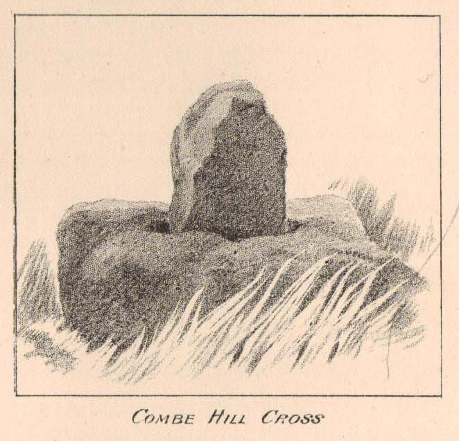
Taylor’s 1906 drawing
Found on the old route between the counties of Yorkshire and Lancashire, this little-known wayside cross has seen better days. Found in relative isolation from other monuments by the ancient trackway (Herder’s Cross is a mile WNW, and the curious Water Sheddles Cross a mile east), its history is quiet and it was ignored in the general surveys of such monuments by Rimmer (1875), Tyack (1900) and Vallance. (1920) Thankfully the giant survey of Henry Taylor (1906) did not forget it—although he seemed to know little of its story, merely telling us,
“The base-stone and part of the upright shaft of this cross stand about one hundred yards in a south-easterly direction from (Far Combe Hill Cross)… Two hundred yards south of the Combe Hill Cross occur the words, ‘Cross Bent.'”
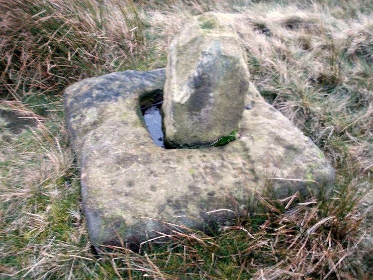
Coombe Hill Cross (photo by Ray Spencer)
The near-square stone base—about 3 feet by 3 feet—is commonly ascribed as medieval in origin and it’s thought that the remaining upright cross-stump—over 2 feet high—is probably not the original one. When fellow antiquarian Ray Spencer visited the site recently, he reported there to be “a faint inscription on the base saying COMBE HILL CROSS.”
The most detailed account of this monument was to be found in Clifford Byrne’s (1974) unpublished paper on the antiquities of the region, where he wrote:
“The pedestal of this cross with a piece of stone sitting in it which may or may not be part of the original monolith is situated on a wayside hillock… On passing the Herders Inn above Emmot, scrutiny of the left hand side of the road at the top of the next rise ahead opposite a white farmhouse will show what looks like a stumpy finger pointing to the sky. Close inspection will show that at the site sits the pedestal of a cross, apparently settled on two steps. Note that the pedestal and the supporting stones beneath have a remarkable resemblance to Carlton Cross which stands on Cross Green between Tom Cross Ainslack and Carleton village near Skipton. It may be that both monoliths were erected by the same hands. Whether the supporting blocks beneath the pedestal were for purposes of kneeling, or merely to stop the edifice sinking into the moor is…open to dispute. An ancient track passes the cross site where it splits into two: one going east towards Keighley and the other going south towards Haworth by Watersheddles Cross. A continuation of the track westwards travels along the foot of Boulsworth Hill past Iron Age burials,* along a fine set of pack horse setts, past standing stones, old lime kilns, and eventually leaving behind some remains of the Wycoller Vaccary stones near Antly Gate Farm. It tops the brow of a hill and drops down through Thursden by the Cold Well itself a a little green gate in the reservoir wall. Marquis of Colne suggested that the Combe Hill Cross dates from the time of King Stephen in the 12th century, but does not say on what he based his surmise…. If the origin of the stone is dated correctly, it has stood near Colne for over 800 years.”
References:
Byrne, Clifford, A Survey of the Ancient Wayside Crosses in North-East Lancashire, unpublished 1974.
Taylor, Henry, The Ancient Crosses and Holy Wells of Lancashire, Sherratt & Hughes: Manchester 1906.
* These Iron Age burials may be Bronze Age as we have found remains of several hut circles dating from that period in this area. PB.
Acknowledgements: Huge thanks to Ray Spencer for use of his photos and additional data for this site profile.
Healing Well (destroyed): OS Grid Reference – SD 540 293
Archaeology & History
Here we have another example of one of the many healing wells destroyed thanks to those industrialists who tend to do that sort of thing. Found in close proximity to several other water sources — including the Syke, Preston’s main watercourse in bygone times — very little has been written of the place. However, in Dave Hunt’s (2005) recent work on Preston, he told us the following:
“The Minspit Well in Mainsprit Weind at the foot of the Church Street ridge is close to the line of the Syke, has a good claim to be one of Preston’s earliest wells, and remained one of the principle water sources well into the 18th century. The ‘spit’ or ‘sprit’ element in the name perhaps indicates the original strongly flowing spring or fountain. The site is now covered over, but Kuerden, writing in the 1680s, describes the picturesque early morning scene as the town’s housemaids collected water in what was accordingly referred to as Pettycoat Alley.”
References:
Hunt, David, The Wharncliffe Companion to Preston: An A to Z of Local History, Wharncliffe: Barnsley 2005.
Similar in size and appearance to one of the cup-marked Tuilyies standing stones in Fife, Scotland, it was our old ley-hunter, Alfred Watkins, who described this stone in his Ley Hunter’s Manual (1927), along with giving us the old photograph taken by one of his mates here, which also showed the cup-and-ring carvings near the base of the stone. Are they still visible? (I’ve not been here, hence mi ignorance!) Watkins thought the cup-markings at the bottom represented some of the local leys—but unfortunately they don’t.
Folklore
Legend says that the deep grooves running down the stone were made by men sharpening arrow-heads on it (like a whetstone). There was also the usual christian Victorian fable that the stone was used by the druids and that the grooves on the stone were where the blood of their human sacrifices was channelled to the ground! The stone was also said to have some relationship with the nearby Calder Stones (which seems probable).
References:
Cowell, Ron, The Calderstones – A Prehistoric Tomb in Liverpool, Merseyside Archaeological Trust 1984.
Watkins, Alfred, The Ley Hunter’s Manual, London 1927.
The holy well/spring can be reached by following the Worsthorne road south from Haggate to Cockden Bridge over the River Don, then following the footpath due east beside the river for about a quarter of a mile. At the Ormroyd footbridge where the River Don becomes Thursden brook head in a north-easterly direction up the hillside. The well, or what’s left of it, can be found beside a trackway.
Archaeology & History
Around twenty-five years ago Calf Hey Well was described as being a square-shaped structure made of five stone slabs, one of which makes the roof. The water, which most probably had some form of mineral content, bubbles up into the large square basin which is a little lower than ground level. Today, the well is still there but I don’t know in what condition it is.
Folklore
According to Clifford Byrne in his book The Holy Wells and Mineral Springs of N.E.Lancashire,
“Calf Hey Well is a strong spring which rises out of the hillside, but in medieval times it was believed that the waters here had special qualities. Some people thought it was a holy well and reputedly many people visited Calf Hey on holy days when jugs of water were sold. A few accounts state that stalls were set up on a flat piece of land to the west of the well, Here vendors not only sold water but other things (food, religious objects and trinkets) and a market atmosphere must have pervaded the site”.
In 1819 the local water company took over the well and began to use its supply of water for the ever growing population of Burnley a few miles west of here. After this the fairie people were never seen again at the well – they were probably feeling very indignant at what had transpired.
Folklore has played its part here too. Fairies are said to have inhabited the well in days gone by – indeed they were often seen dancing around the well in the moonlight. These fairies or “little people” were not just creatures of the night which our ancestors delighted in when they could catch a rare glimpse of them. In fact these little people were quite normally formed although small in stature. Though not human they had the capacity to intervene in our human affairs – usually but not always for the good of it. They were known to steal little children and babies, supplanting them with their own offspring. So the parents of newly born babies had to be very vigilant and get their babies baptised as quickly as possible.
There are a few lesser-known wells in the same area as Calf Hey. These include The Jam Well at Worsthorne, Sweet Well at Holden Clough and Robin Hood’s Well at Black Clough, Thursden.
References:
Byrne, Clifford, The Holy Wells and Mineral Springs of Northeast Lancashire, MS copy in Nelson Public Library (Reference).
Frost, Roger., A Lancashire Township – The History of Briercliffe-with-Extwistle, Rieve Edge Press: Briercliffe 1982.
The low hill called Beadle Hill is located about half a mile north of Swinden Reservoir between Worsthorne and Haggate in the area called Extwistle. It is just a short distance south of Monk Hall and a little east of Monk Hall farm. The earthworks are a long rectangular feature on a low hill (more of a mound really).
The earthworks are more noticeable on the south and west sides but less so at the eastern and northern edges of the mound. They can’t be said to be in any way defensive. The thinking is that this was a Romano-British farmstead or settlement from the late 4th century AD and, not as often thought a Roman camp. The name Beadle is apparently from the Anglo-Saxon/Old English word ‘Beado‘ or ‘Beadlo‘, meaning ‘battle.’ So could the hill be the site of some long forgotten skirmish from the time when the Romans were leaving the north of England? Or could it refer to the legendary ‘Battle of Brunanburh’ which was fought close by in 937 AD? In that battle King Athelstan fought against, and defeated, the Danes and Scots who were moving south from Northumbria.
At the south side of Beadle Hill there is an ancient spring, and to the east is Twist Castle—a circular earthwork that could date from the same period as Beadle Hill. Also, there are a number of tumuli and cairns in this area though these are prehistoric in date, probably Neolithic or Bronze-Age. I do not know whether the site has been excavated. If it has, please let us know!
References:
Cockburn, John Henry, The Battle of Brunanburh and its Period, Elucidated by Place-Names, Sir W.C. Leng: Sheffield 1931.
Frost, Roger, A Lancashire Township – The History of Briercliffe-with-Extwistle, Rieve Edge Press: Briercliffe 1982.
Tumulus (destroyed): OS Grid Reference – SD 873 277
Archaeology & History
A prehistoric cairn or tumulus could once be found close to the grid-reference cited here, but all trace of it has long since been destroyed. The site was mentioned briefly in Thomas Booth’s (1899) short survey on the prehistoric tombs of the area, telling:
“I have omitted to mention in its proper place a find which took place at Holmes Chapel about the year 1826. The particulars are very meagre but, according to a local journal published some fifty years ago, called The Comet (edited by the late Abraham Stansfield), some workmen who were engaged in pulling down a barn at Thieveley discovered an ancient urn, whose contents were of a similar kind to those of other urns of this class.”
The “other urns” he mentions are those that have been found in prehistoric tombs on the north side of the same valley, including those at Cliviger Laithe, at Catlow, at Delf Hill and other sites close by. Remains of another prehistoric cairn can be found close by on top of the hill at Thieveley Pike to the south, where a beacon was built, damaging the original tomb.
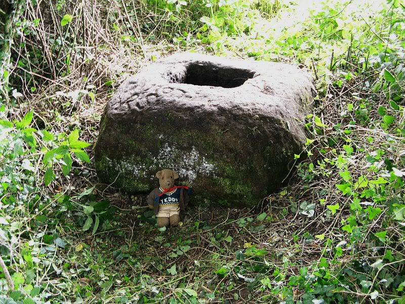
Take the B6478 road between Clitheroe and Newton, heading up north out of Clitheroe until you’re on the very top of the hill with fine views, mainly north and west. There’s a car-park about here, on the right-hand side of the road. From here, walk further along the road for about 200 yards, keeping your eyes peeled for the large stone trough at the left-hand side of the road. That’s it!
Archaeology & History
When we met up with John Dixon in the summer of this year, to wander on the nearby hills in search of old monuments, this was the first spot he showed us — and the waters were flowing nicely and tasted alright aswell! But its history is not widely know. Jessica Lofthouse (1976) described the place, saying:
“In the days of horse and pedestrian traffic none passed Walloper Well without stopping to ‘quaff the clear crystal.’ Long ago, hill men, hunters, forest wardens and farmers off to Clitheroe markets and fairs, pedlars, lead miners from the nearby workings, all met here. The name is thought-provoking. Why Walloper? From a word meaning a ‘fresh bubbling spring’, which this is, fresh from the moorside into stone troughs. Age, wartime army practice and vandalism of 1974 made renewal of the trough necessary, but the flow has been constant. One must drink, just as one throws pennies into the Roman fountain, to ensure one comes back again.
“The true derivation does not satisfy everyone. One can choose. A man and his wife climbed towards Walloper with raised voices, she nagging, he protesting. A pedlar watched them. “I’ll tell thee what I’d do if she were my wife. I’d wallop her, wallop her, wallop her well.” A song which every local singer was once compelled to have in his repertoire told the same story. The chorus sums up the reason for the name:
“…lovers of tell, each beau to his belle
The olden time story of Walloper Well.
The mason who built it in love with a maid
Who brought him his dinner one day, so tis said,
Was struggling to kiss her when over the Fell
A pedlar then passing cried, ‘Wallop her well’.”
References:
Byrne, Clifford H., Mineral Springs and Holy Wells of North-East Lancashire, unpublished manuscript, 1972.
Lofthouse, North Country Folklore, Robert Hale: London 1976.
Take the B6246 road northwest out of Whalley, or else east from Hurst Green, until you hit the little village of Great Mitton, with its churchyard in the middle. Go into the churchyard and you’ll find this weird-looking cross!
Archaeology & History
The curious-looking upright in the churchyard here has a mixed history by all accounts. The oldest portion of the cross is universally ascribed to be the top section, rediscovered when it was dug up “shortly before 1801.” (Ackerley 1947) It possesses a carving of the crucifixion on one side, and some curious figures carved on the other, which some ascribe to being Jesus, but could well be the triple female element which would still have been prevalent in peasant culture at the time it’s thought to have been carved. The original shaft carrying the ‘cross’ had long since been destroyed and so, according to Jessica Lofthouse (1946),
“In 1897 it was ‘re-erected to commemorate the 1300th anniversary of the reintroduction of christianity into Britain,’ with the new shaft we see today. This is the oldest relic in Mitton.”
In J. Buckler’s early 1841 drawing of both sides of the carved cross-head we can see in greater detail the nature of the medieval rock art and this was described in Aymer Vallance’s (1920) decorative analysis of carved crosses in England. He told that
“the cross-head at Mitton, Yorkshire…is peculiar inasmuch as the crucifixion is sculptured on both faces, but in totally different fashions. That on the west face has the arms stretched horizontally, within a sexfoil frame, and might well be of the thirteenth century. Whereas the sculpture on the east face, though much more weatherworn, is of a style that could not have been designed before the fourteenth, or perhaps even the fifteenth century. The arms of the Christ in this instance are drawn upwards in an unusually oblique direction. It is impossible that these two representations could have been executed at one and the same date. The circular outline of the head, too, is peculiar, and suggestive rather of a gable-cross than of a standing cross. Possibly the west face only was sculptured in the first instance, for a gable-cross, the sculpture on the east face being added later in order to adapt the stone for the head of a churchyard cross.”
Although I’ve gotta say that the three carved figures with the upright arms strikes me more as three females than any crucified character and may be an early depiction of the three Mary’s.
One of the early ministers at Mitton church was none other than John Webster, who wrote the highly influential work, Displaying of Supposed Witchcraft, which denounced much of the Church’s obsession and murder of countless people under the auspice of some spurious devil and demonological bollocks which, even today, some still suffer to endure. Webster was only at Mitton for a few years, before moving into deeper Yorkshire and setting up at Kildwick.
References:
Ackerley, Frederick George, A History of the Parish of Mitton, Aberdeen University Press 1947.
Lofthouse, Jessica, Three Rivers, Robert Hale: London 1946.
Vallance, Aymer, Old Crosses and Lychgates, Batsford: London 1920.
From Great Mitton village, go up (north) the slightly winding B6243 road for a mile, then take the left turn up the minor country lane, for about 300 yards, till you reach a tiny crossroad of tracks, one leading down to Scott House and the other up to Withgill Farm. Stop here! You’re damn close. From what our man ‘QDanT’ says, this is now to be found behind the hedge by the roadside, on the side of the road where the track runs up to Withgill Farm, tucked low and overgrown close to the ground. Good luck!
Archaeology & History
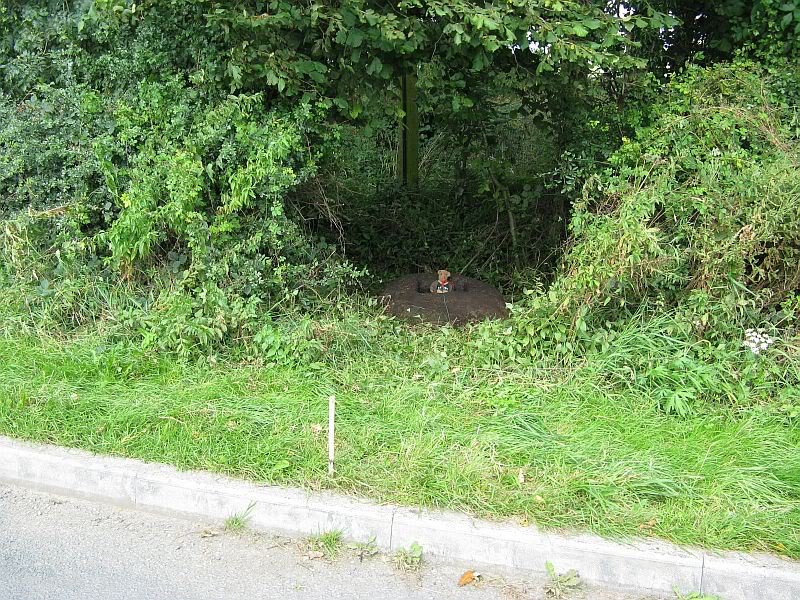
Described by Mr Ackerley (1947) as being found
“in the coppice beside the gate to Withgill is the base of another road-side cross,”
Cross-base (after QDanT)
all but overgrown by ivy and lost to the causal eye. Thankfully our man Danny got on his bike and found the remains of the little fella, all-but invisible beneath the vegetative growth! Beneath the vegetation, John Dixon told there to be “some interesting 17th century graffiti,” but there’s not much that remains of the old cross.
Folklore
There is a curious story about a legendary church that was once supposed to have been up the track on the hill just above here at the farm. The story goes,
“that when Mitton church was built, it ought to have been built on Withgill Knowle: that there was a church somewhere about there, and that the stones from it were carted down to Mitton in one night and used in building the present church.”
This bitta folklore is a motif found commonly at prehistoric sites, where stones from our ancient places were uprooted and moved (destroyed) to give way to the new christian mythos. To my knowledge, no such prehistoric sites are known hereby. Mr Dixon – over to you dear sir!
References:
Ackerley, Frederick George, A History of the Parish of Mitton in the West Riding of Yorkshire, Aberdeen University Press 1947.