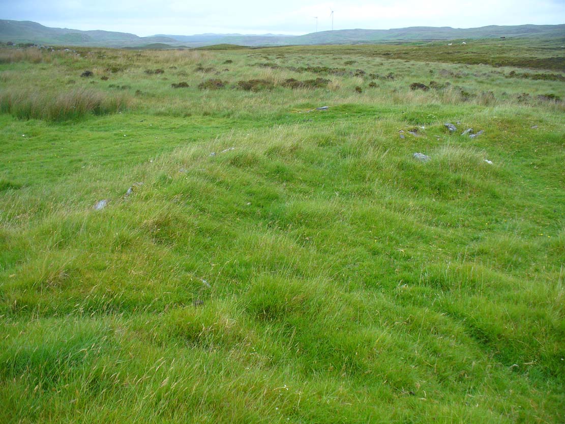
Along the A836 road a mile east of Bettyhill, a track goes south onto the moors just before Loch Salachaidh. Walk along here for several miles, past the windmills and past the Achadh Thaibstil Cairn, until you reach the remote green fields that are the remains of the clearance village of Achamore. As you walk into the green grasses, a ruined building is to your left. In front of you, a large raised round structure almost entirely covered in grass. You’re here!
Archaeology & History
This is a curious structure – and were it not for being labelled as a ‘hut circle’ by the lads at Ordnance Survey, on first impression I’d be more tempted to classify it as either a collapsed broch, or a large cairn circle. This is entirely due to the size of the thing, as it’s big for a hut circle!
NW arc of the circle
Eastermost embankment
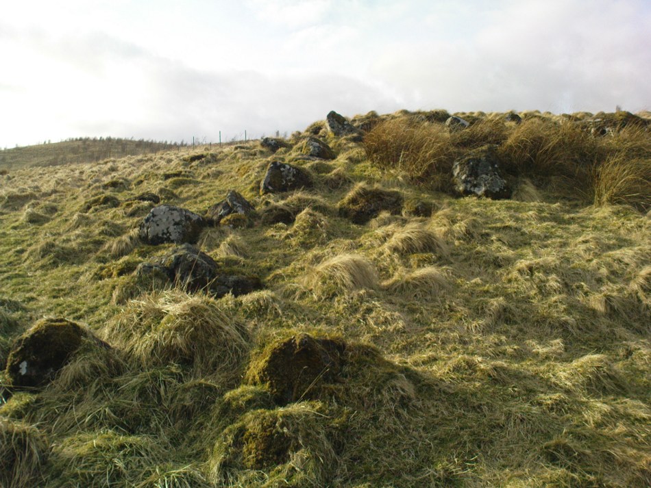
Circular in form, the sides of the structure on its eastern face are nearly three feet high, piled at an angle of nearly 45 degrees, and several feet across before you reach the internal section of the said ‘hut circle.’ As you walk around it, the height of the piled stones diminishes to between 1-2 feet, but the diameter of the walling all round is consistently wide – increasing the thought of it being a collapsed or robbed-out broch. The diameter of the structure is some 20 yards across, with an approximate circumference of 64 yards.
‘Hut circle’ atop of nearby hill
Another “hut circle” is immediately visible some 80 yards to the south, on top of the nearby grassy hilltop. The majority of this is also covered in meadow grasses, with edges and upper surfaces all but hidden. On its southeastern edge is what looks like a structural stone ‘entrance’ some two yards across and three yards long.
Other smaller hut circles in the area indicate that this region – like others nearby – was a place of consistent human habitation from prehistoric (probably Neolithic) times, unbroken all the way through until the 18th century.
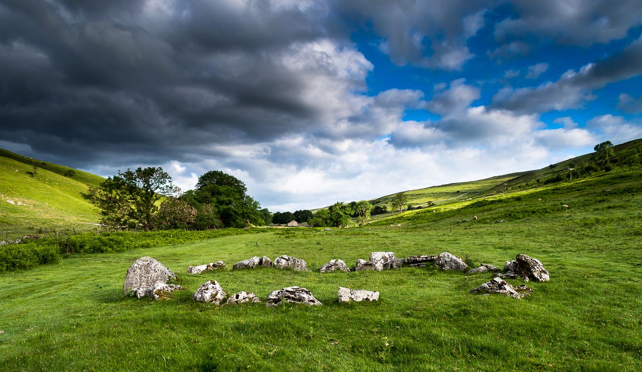
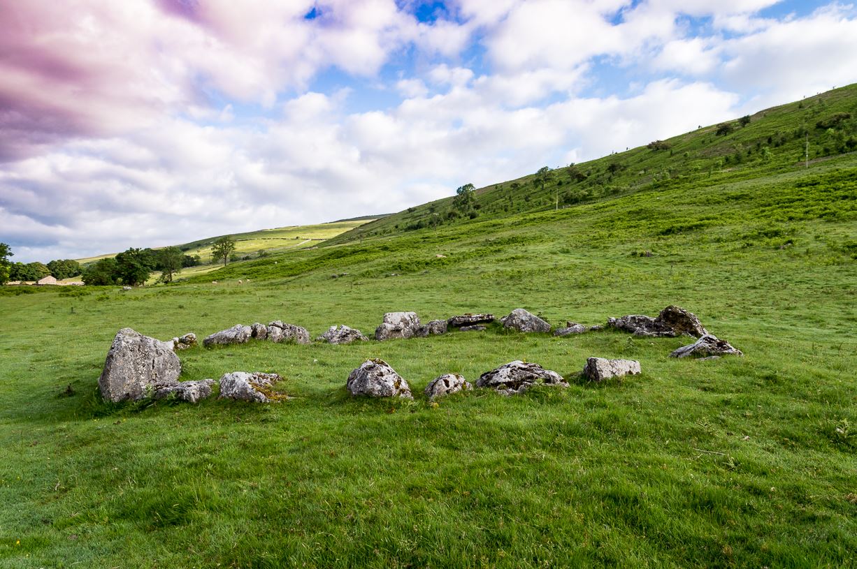
The long country road running between Aysgarth and Kettlewell is the B6160. Whether you’re coming from the north (Aysgarth) or south (Kettlewell), when you reach either Buckden or Cray, take the minor road west to Hubberholme. Just over 1½ miles further on, you reach the tiny hamlet of Yockenthwaite itself. Cross the river bridge, then turn left and walk along the footpath parallel with the river. 600 yards or so along, keep your eyes peeled for the low small ring of stones in front of you.
Archaeology & History
Just above the well-trod path that runs parallel with the usually shallow River Wharfe, this small and silent ring of stones rests in the idyllic host of Langstrothdale, deep in olde Yorkshire. Tis a wonderful spot… Classed as a ‘stone circle’ for many a decade (even by the esteemed Aubrey Burl), this small but ancient ring shouldn’t really be held in the same category as our larger megalithic circles. In truth, it looks more like some of the larger hut circles I’ve seen and uncovered down the decades—and it may well be that. Indeed, even the archaeo’s aren’t in agreement as to what it is, with the general idea being that it is the remains of a ring cairn of some type, despite no human remains being found here.
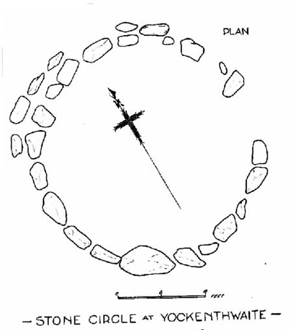
Raistrick’s 1929 planLooking northwest
Yockenthwaite itself was already know by this name in 1241 CE, when the monks of Fountains Abbey were given the land by one of the murderous invading Norman families of the period. This ingredient may be relevant to the history of the circle, for as the great northern antiquarian Harry Speight (1900) pointed out,
“in several places in the dales there are traces of what seems like ancient sheep or cattle enclosures, which are probably vestiges of this grant to the monks of Fountains in 1241.”
And Speight thought the circle had a similar origin to these remains. He continued:
“An enclosure of this kind, composed of a number of big stones on end, lies at the low end of the second pasture on the north side of the river between Yockenthwaite and Deepdale, and has been described as a Druid’s Circle. It is doubtless one of these monastic folds.”
And he may have a point. Although when Arthur Raistrick (1929) ventured here in the early 1920s, he had other ideas, pushing the date of the site way way back into the Bronze Age. “The circle,” Raistrick told,
“is slightly raised above the surrounding ground-level, and the stones, standing edge to edge, can be seen from a considerable distance on either fell side. The circle is 25 feet diameter, very nearly a true circle, there being only about 6 inches variation in diameter. The stones number 20, placed on edge to edge to edge…with only two small gaps, which would accommodate three or perhaps four more stones. These stones were probably removed some years ago to repair the stile in the neighbouring wall. Outside this circle of 20 stones, on the northwest side, there are four others placed concentrically, and very close to the circle, but there is no evidence that the circle was ever double, or that there were ever more than these extra four stones. There is a slight mound at the centre, and probing with a rod proved a small circle of stones, about 9 feet diameter at the centre, indicating probably a burial. Several large boulders lie on the level ground around the circle, but these are all rolled down from the fell-side above, and not placed in any connection with the circle. All the stones of the circle are of limestone…”
It was this designation that led to Burl (1976; 2000) to include it in his corpus of megalithic rings; although John Barnatt (1989) did question the validity of the site as a true ‘stone circle’ in his own gazetteer, saying:
“This unusual site comprises a contiguous ring of orthostats of c. 7.5m diameter, which are graded downslope to the SSW to allow for the gradient; their tops are all roughly horizontal. They range from 0.30 to 1.05m in height, 22-3 stones survive today and 3-4 appear to be missing. To the NNW there is a short outer arc of 4-5 stones placed immediately outside the main ring. 4 loose stones appear to have been added to the ring recently. Raistrick’s plan does not tally with the present remains, despite the sites undisturbed nature. The interior of the site is filled by a low horizontal platform, with virtually no height upslope to the north-east and a height of c. 0.5m to the south-west. The ring of stones stand well proud of this round the full circumference. This site appears to be a variant form of kerb-cairn rather than a true stone circle.”
The structure has been built onto a slight but notable platform, as has also been done with many hut circles—and the Yockenthwaite site may just be one of them. Only an excavation will tell us for sure. It’s isolated from other remains, but on the hills above, both north and south, denuded Iron Age and Bronze Age settlements look down on this solitary ring. Whatever it may be, it’s olde and in a beautiful setting. Well worth checking out if you like yer ancient sites!
References:
Barnatt, John, Stone Circles of Britain (2 volumes), BAR: Oxford 1989.
Burl, Aubrey, A Guide to the Stone Circles of Britain, Ireland and Brittany, New Haven & London 1995.
Burl, Aubrey, The Stone Circles of Britain, Ireland and Brittany, Yale University Press 2000.
Elgee, Frank & Harriet, The Archaeology of Yorkshire, Methuen: London 1933.
Longworth, Ian H., Regional Archaeologies: Yorkshire, Cory, Adams & MacKay: London 1965.
Raistrick, Arthur, ‘The Bronze Age in West Yorkshire,’ in Yorkshire Archaeology Journal, volume 29, 1929.
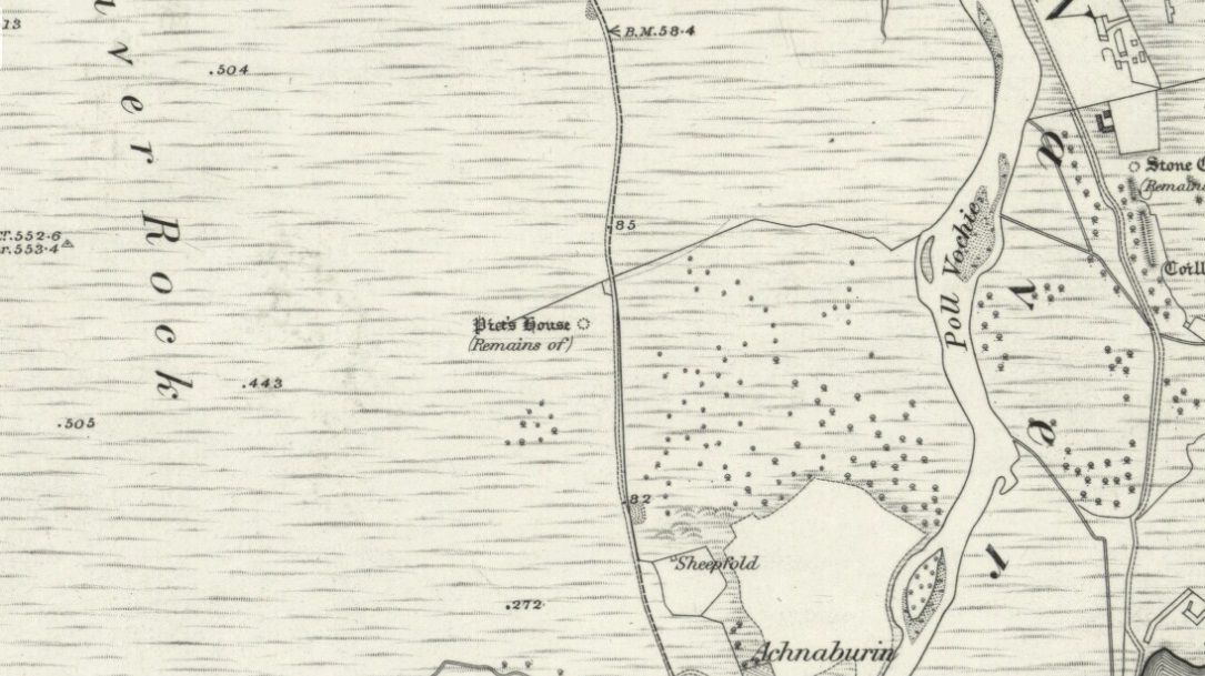
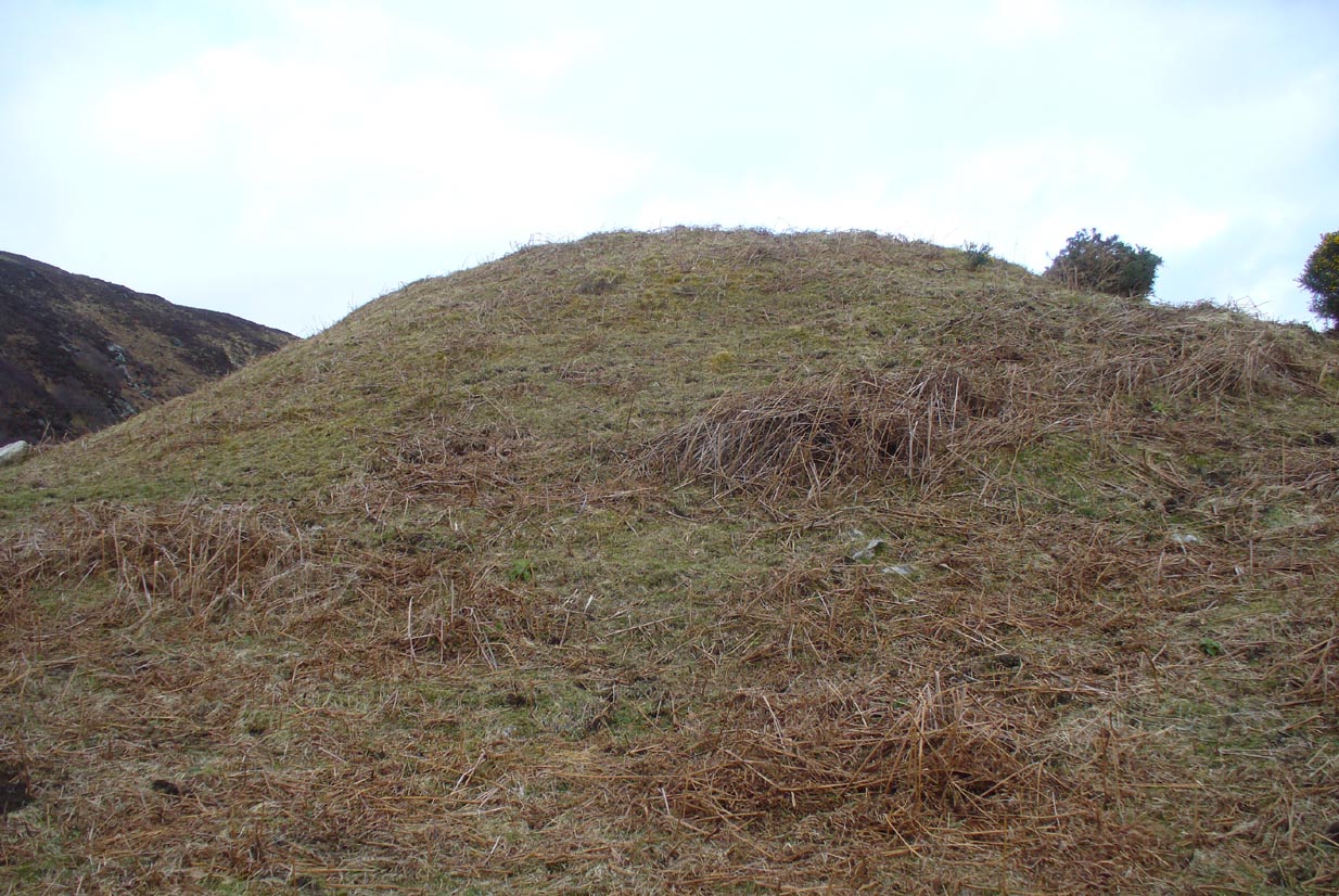
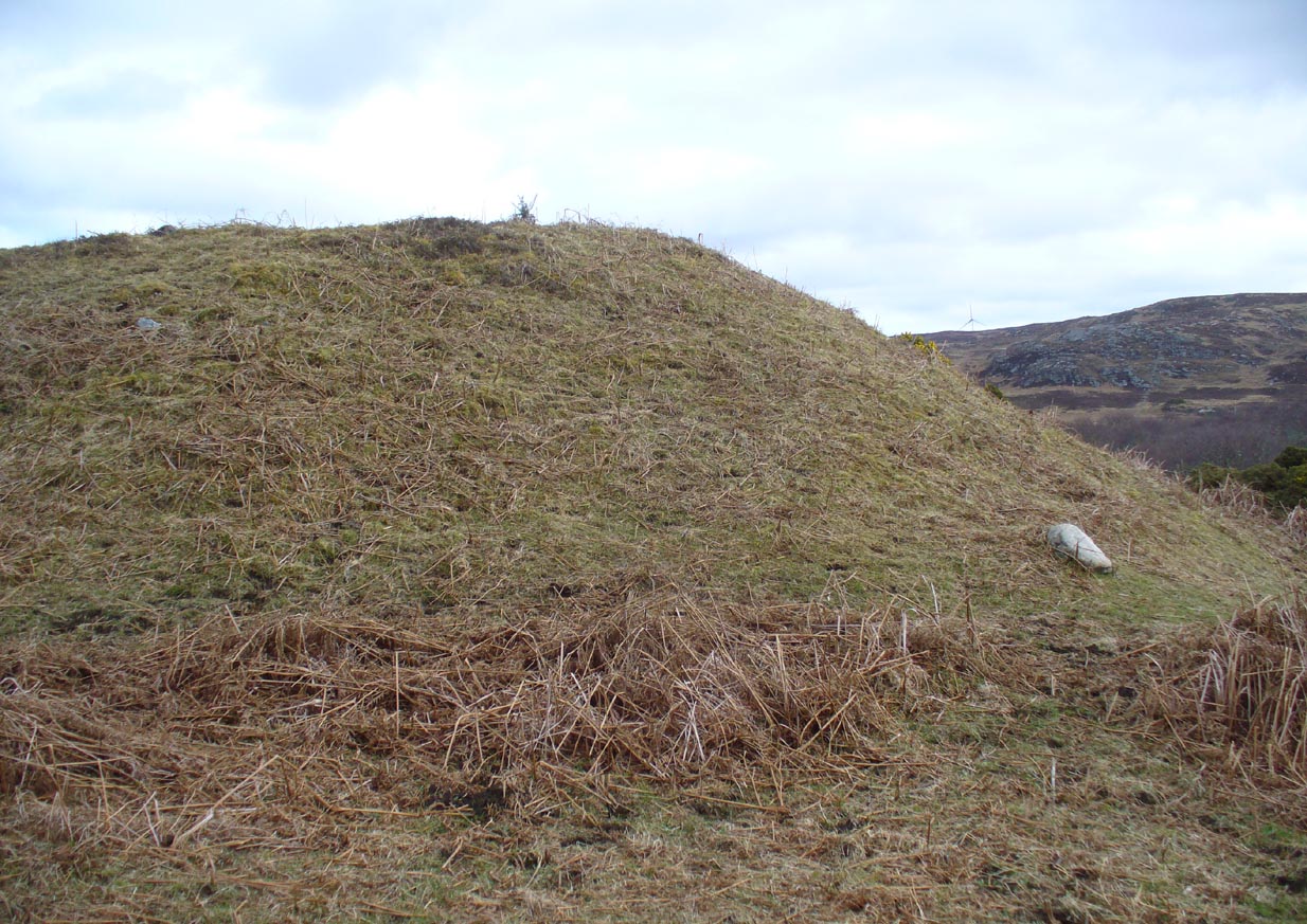
From Bettyhill village, take the A836 road as if you’re going to visit Tongue, crossing the metal bridge across the River Naver a mile south of Bettyhill. Keep going past here for nearly a mile, beyond the houses and then into the small trees, making sure that you keep your eyes peeled to the right where a small but notable bracken-covered mound rises 10-20 yards in the rough field. Go through the gate and you’re there!
Archaeology & History
Low stone wall along S side
A site which, from the nearby roadside, has all the hallmarks of being yet another Sutherland broch (there are tons of them up here!)—but apparently it isn’t! Despite being shown on the earliest OS-map of the region as a ‘Pict’s House’ (which are usually brochs), the site has subsequently been designated by modern archaeologists as a simple ‘hut circle’. I have my doubts over this, as it’s a most unusual one with little logic over its positioning—unless it was either a look-out point, or an odd ritual spot.
South side of the mound
As you can see from the poor photos I got of the place, a large angled tumulus-like hillock (it’s akin to a mini-Silbury Hill at first sight) rises up from the ground with a reasonably uniform angle around much of it, to a height of between 16-20 feet. Scattered rocks and stones adorn the mound as you walk up its embankments and onto the top where, around the edges, a notable man-made ring of walling shows it to have been artificially created. Unfortunately most of the top of the mound was completely covered in thick decayed bracken when I visited, so it was difficult to get any good photos of this topmost walling.
The SE side of the mound
From the top of the mound, the walling is between 1-3 feet high, in a roughly circular setting, measuring 36-40 feet across. The most distinct section of it was visible on the west-to-south-to-east section; with the lowest and depleted section occurring on its northern edges. The entrance to the ‘hut circle’ is apparently on its eastern side. Although it is assumed to be Iron Age in nature, its real age is unknown.
References:
Mercer, R.J. & Howell, J.M., Archaeological Field Survey in Northern Scotland – volume 2, University of Edinburgh 1976-1983.
Take the same directions to reach the giant Carn Ban prehistoric tomb. Follow the track past the tomb further onto the moorland until you reach a small wooden bridge over the small burn. From here, walk straight north off-path onto the moor for 100 yards and a small rise in the land, with several cairns just below it, is the site in question.
Archaeology & History
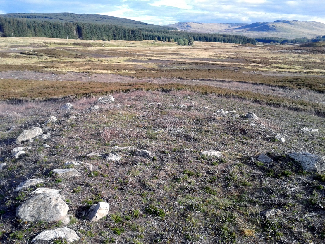
Hut circle are hut circles – right? Well, usually that’s the case. We find them attached to, or within, or outlying prehistoric enclosures and can date from anywhere between the neolithic and Iron Age periods. With the site we’re looking at here, on the outer western side of Glen Cochill’s southernmost giant enclosure, there’s something amiss….or maybe that should be, “something rather peculiar.”
Mr Hornby, hut-sideShamans Lodge walling
Paul Hornby found it a few weeks ago during an exploration of the region’s prehistory. We went in search of, and found, the giant Carn Ban close by, but noticed curious archaeological undulations ebbing in and out of the heathlands: cairns, walls, hut circles, settlements, more cairns—and then this!
Consisting of two slightly larger-than-average ovals of walled stone, probably Bronze Age in date, the first impression was of a remarkably well-preserved site (and that it is!), seemingly of an elongated stretch of walling, with a central wall that split it into two halves. Each ‘hut circle’ was found to be between six and seven yards across, with the two conjoined architectural features giving an overall NW-SE length of 14 yards. But the more we looked at this, the more obvious it became that this was originally one single hut circle—the lower southeastern one—with an additional one that was added and attached onto the northwestern side at a later date, probably several centuries later.
Lower earlier hut circle, with upper later hut circle attached
Walking around the structure we found that the very well-preserved walls—about 2 feet wide in places and rising a foot or so above the compacted peat—had been built onto a raised platform of earth. This was no ordinary hut circle! The ground beneath it seems to have been raised and supported and on the southern side in particular it is notable that other building stones are compacted into the peat. There may even be the remains of a secondary outer wall on this southern edge, where it seems that the entrance was made.
Small group of cairns 15 yards away
Here’s the curious bit: immediately outside the northwestern and southern walls are small prehistoric tombs, or cairns. Not just one or two, but more than a dozen of them, all constructed within 20 yards of this curiously raised double hut circle. Literally, a small prehistoric house of some form was raised in the centre of a prehistoric graveyard—and it doesn’t end here.
Of at least three giant enclosures in this region, and what looks like a very well-preserved prehistoric tribal hall or meeting place, there are upwards of a hundred tombs scattered nearby. Two cairn circles were also found about 100 yards to the north, one of which was damaged by a military road a few centuries ago.
Close-up of walling
I give this double-roomed abode the somewhat provocative title of the Shaman’s Lodge because of its setting: surrounded by tombs, the ‘house’ would seem to have been a deliberate setting erected in the Land of the Dead here. I hope you can forgive my imaginative mind seeing this as a structure where, perhaps, a medicine woman would give rites to the dead, either for those being buried in the small graves, or rites relating to the giant White Cairn of the ancestors close by. Shamans of one form or another occur in every culture on Earth and have been traced throughout all early cultures. If no such individuals ever existed within the British Isles, someone needs to paint one helluva good reason as to why they believe such a thing….
When the heather grows back here, the site will disappear again beneath the vegetation. It is unlikely to re-appear for quite sometime, so I recommend that anyone wanting to have a look at this does so pretty quick before our Earth covers it once again….
References:
Stewart, Margaret E.C., “Strath Tay in the Second Millenium BC – A Field Survey”, in Proceedings Society Antiquaries Scotland, volume 92, 1961
Acknowledgements: Huge thanks again to Paul Hornby for his assistance with site inspection, and additional use of his photos.
Go up the B6160 road, heading for Kilnsey Crag. A few hundred yards past here, take the road to Arncliffe and, several hundred yards along, keep yer eyes peeled for the (usually) decent craggy dry stream bed on your left (west). Follow this upstream till you hit the large cave, continuing uphill above the crags, following the steep walling upwards to the next set of crags. Above these, another long straight line of walling continues in the same direction you’ve been walking. Follow this along until it meets up with another large line of walling, heading NE. Walk along here till this wall changes direction NE, but here you need to walk across the grasses westwards, past the large cave for another 100 yards. You’ll find it!
Archaeology & History
This is a simple but well-preserved circular monument, probably constructed in the Iron Age, just 100 yards past the incredible Douky Bottom cave (in which various prehistoric remains have been found). No excavations appear to have been made here, yet the near-perfect ring is in very good condition indeed. The monument consists of thousands of small stones – taken from the huge scree immediately behind the structure – whose uppermost visible mass overlays a much older and larger pile of stones, all of roughly the same size.
Douky Bottom ring, looking NE
The ring is less than 10 yards across and gives the impression of it being a large hut circle—which it may or may not be. Without an excavation we cannot know its function with any certainty. Other, much larger prehistoric enclosures and settlements are close by, mainly to the northeast; and you have the truly bizarre rock piles on the ghostly horizon crags, whose histories are quiet indeed…. For any antiquarians amongst you who’d like a good day out, give this region a try! It’s a truly intriguing arena with much much more hiding away than any of the archaeology records can tell you about.
Acknowledgements: Many many thanks to James Elkington for guiding us to the sites in this region.
Along the A823 road from the Pool of Muckhart up to Glendevon, watch out for the small left turning opposite the car-parking spot by the Castlehill Reservoir a couple of miles up the road. Walk up this small road a mile or so to the Glenquey reservoir, taking the footpath on your right and making sure you walk along the north-side of the waters. You’ll eventually reach a small set of beautiful mossy green waterfalls (with the rounded fairy hill of Maiden Castle ahead of you). This is the Garchel Burn. Take steep the path up the side until it levels out a bit, heading for the small clump of stones on the near skyline a couple of hundred yards ahead. That’s it!
Archaeology & History
This is a curious little cluster of seemingly multi-period remains sitting on the edges above the gorgeous waters of the Garchel Burn. The Royal Commission Canmore report ascribes the scattered rocky cluster below the deer-fencing as the main hut circle – and the line of walling running slightly down the slope does have that traditional Iron Age look about it. But it’s yet to be excavated. The larger ring of stones constituting the main ‘circle’ is very much bogged-down, literally, amidst tussock and marshland, with an arc of stones running away from the circle and it’s obviously been made use of it by people in more recent times.
Small ‘hut circle’ to centre
Below the larger rock cluster is a lovely oval structure, built upon a slight rise overlooking the burn, with all the rocks in the structure overgrown with age and grasses. Tis a beautiful spot to sit and hear the silence of the waters around you. Aerial images show the outlines of other roughly circular remains in the same area, but none are yet excavated – and some are distinctly much later in period, medieval by the look of things and very probably used by farmers in more recent centuries. In all probability, there are more things to be found up here, hiding within the forests…
Cowling’s 1946 ground-plan of a portion of the settlement
From Blubberhouses church by the crossroads, walk up the slope (south) as if you’re going to Askwith, for 100 yards or so, taking the track and footpath past the Manor House and onto the moor. Once you hit the moorland proper, take the footpath that bears left going down into heather and keep going till you hit the dead straight Roman Road path running west onto Blubberhouses Moor. Go on here for nearly a mile until you hit the valley stream with its Eagle Stone down on your left. Walk downstream, past the Eagle Stone, and cross over 100 yards down until you’re back on the level ground with the scatter of bracken and heather. You’re here!
Archaeology & History
On the other side of the stream a short distance southeast of the large cup-marked Eagle Stone is a curious site, first described by Eric Cowling (1946) as “a series of enclosures of varying size and roughly circular shape” which he ascribed as a Bronze Age settlement. Certainly we have a rather extensive scattered group of walled structures just as he described, but not all of the walling here seems typical of local Bronze Age constructions. Cowling suggested the remains to be “useful for protection, herding and for shelter,” though admitted archaeological excavation would be the best way to ascertain their specific nature. Such undertakings have yet to be done — and I wouldn’t hold your breath either.
Large section of wallingWalls of large circular structure
Although he described some of the walls here as nearly four-feet tall, when Graeme Chappell and I first ventured here in the winter of 1990, the walling wasn’t quite as high. There are a number of individual tall stones sat in the walls that stand three-feet tall, with some that have been cut and dressed in more historic times. Who did this and when is unknown. However, if we visited this place when all the vegetation has been cut and burnt back at the end of winter and early months of Spring — a fact not lost on Cowling when he first found this place — we would gain a much clearer picture of things here.
Some sections of lower walling above the streamside appear to be prehistoric in nature, but many other parts of the walled structures across this flatland plain have a much later look and feel about them, illustrating that the site may have been used well into post-medieval periods. This seems increasingly obvious where we find a number of the stones cut at sharp angles, with some having distinctive quarried grooves in them. However, I can find no historical records to verify this at present.
Hut circle remainsMedieval cut upright stone?
If we walk up the slight slope westwards however (before bracken and heath grow) there are more distinct prehistoric remains in the form of typical hut circles with low walls emerging from deep peatlands — although even these have been cut in one or two places by metal tools. My view of this little-known but large settlement arena is that we’re looking at a site initially built in the Bronze Age period, continuing to be used by local tribespeople throughout the Iron Age and, as the cut stones clearly show, was a village that was certainly made use of in the last millenium. But until someone comes along here and gives the site the attention it deserves, we’re not gonna know…
On the southern fringe of the copious walled structures we also find a very curious medicinal chalybeate spring that may have been of some importance to those who once lived hereby. A ‘standing stone’ and prehistoric cairn can also be seen close by.
References:
Cowling, E.T., Rombald’s Way: A Prehistory of Mid-Wharfedale, William Walker: Otley 1946.
Follow the directions to reach the Lippersley Pike cup-marked stone, then keep walking westwards, but go up the slope immediately on your right (north) and walk upwards along the path to the notable stone structure at the top-end of the ridge a coupla hundred yards ahead. Once there, you’re standing on it!
Archaeology & History
Lippersley Pike & shooter’s butt
A little known site with some excellent 360° views all round, reaching as far west as Pendle Hill, north past Simon’s Seat, and east onto the far reaches of the North York Moors. The landscape here is truly superb! And humans have been here since, it would seem, mesolithic periods at least, if Cowling’s finds are owt to go by! For although he described the much denuded tomb that we can still see under the herbage and recently-built shelter, there was also, “on the northern slope…a small occupation immediately below the summit on the northern side.” We found remains of it on our visit here the other day. But of the tomb itself — which Mr Cowling thought was neolithic in age — he wrote:
“The highest point of Lippersley Pike, on Denton Moor, is crowned by a stone cairn 1083 feet above sea level, and overlooks, on the northern side, a small site which appears to have been occupied by the ‘Broad Blade’ people, for there occur several pieces of patinated flint, along with scrapers and worked blades.”
Aerial view of Lippersley Pike
Cowling then describes a number of flints and other prehistoric working utensils that he found all round here. The remains of the cairn measure some 25 feet east-west and 23 feet north-south. There has been no excavation here, although the fella’s who dug out much of the stone to build the shooter’s butt on its top may have found summat, but have kept it quiet!
The cairn is an ancient marker along the boundary line marking the townships of Denton and Great Timble and was visited in perambulation walks in previous centuries. Grainge (1871) describes the extensive perambulation in his Knaresborough Forest work. ‘Lippersley’ itself first appears in records from 1576, although A.H. Smith (1963:5) does not suggest an etymology. The place is worth visiting as a good starting point to explore the other little-known prehistoric remains on these moors, including the Crow Well settlement, the Heligar Pike tomb, etc, etc.
References:
Cowling, E.T., Rombald’s Way: A Prehistory of Mid-Wharfedale, William Walker: Otley 1946.
Grainge, William, The History and Topography of Harrogate and the Forest of Knaresborough, John Russell Smith: London 1871.
Grainge, William, The History and Topography of the Townships of Little Timble, Great Timble and the Hamlet of Snowden, William Walker: Otley 1895.
Smith, A.H., The Place-Names of the West Riding of Yorkshire – volume 5, Cambridge University Press 1963.
Follow the same directions to get to Bordley’s Druid’s Altar circle. Where the little rough car-parky-bit happens to be by the cattle-grid, look up the sloping field where the wall runs up in a line and follow it up on foot. A coupla hundred yards up you’ll see a small craggy outcrop in front of you and another line of drystone walling in the corner. Just below this craggy outcrop you’ll notice a raised embankment comprising a line of small rocks running along the edge of the hill. This is the first bitta prehistoric walling that makes up a part of the settlement system. From hereon, follow y’ nose along and up the hill and look around. The settlement’s all around here!
Archaeology & History
This is quite an extensive area of prehistoric (seemingly Iron Age) enclosures on the top and around the edges of the unnamed rocky peak at the top of the large open Lantern Holes field. I’m not aware of any excavation work that may have taken place at this site, so please excuse me of any errors in the description that follows. (if anyone’s got an excavation report of the site, I’d love to read it!)
As with the many other settlements and enclosures in this region, much of it comprises of extensive stonework built up into and against the geological limestone bedrock either side of this hilltop site. Huge lines of prehistoric walling, measuring anything between one and three yards across, runs for hundreds of yards in and around this set of enclosures. We also find several distinct and well-preserved examples of old hut circles (one of which appears to have been re-used as a sheep shelter in more recent centuries) dotted around the edges and in the middle of larger sections of enclosed stone walls. This is all very impressive when you consider it was done a coupla thousand years back!
Walled enclosure on south sideWalling along SW edges
Very similar in design to the prehistoric settlement enclosures on the other (south) side of the valley at Hammond Close Pasture, above the Druid’s Altar, though more extensive. Measuring roughly 340 yards (311m) along its longer southeast-northwest axis, and nearly 280 yards (254m) from east-to-west, the uppermost parts of the site have at least seven separate large elliptical ‘enclosures’ built within the rocky enclaves, made up of typical Iron Age wall systems: a series of large upright monoliths packed up by smaller packing stones all along the length of the walling (using a system that still prevails today in drystone walling techniques on our upland moors). A couple of the photos here illustrated the walling very well and give you an idea of what to look out for if you’re out wandering the region, looking for old sites.
Although the walling we see today is barren and easy to spot, remember that in the time when people built these great structures, you wouldn’t have been able to see them, as they’d have been deliberately covered over and camouflaged with dressed earth and plants. In watching people emerging from these enclosures, you’d have got the distinct impression that they literally came out of the hill itself: a motif well-known to folklorists in relation to the origin of faerie-folk and other ‘little people.’
We need to go back up here and explore this settlement a bit more, as there’s tons more to be seen. And if anyone knows of any surveys that have already been done of this site, it’d be good to read the reports, preliminary or otherwise. A rough-camping weekend is planned on the tops at the break of Spring – so contact us if you’re into joining us for the amble. I reckon there’s gonna be other sites hidden in the landscape up here that even Arthur Raistrick missed out on!
…to be continued…
References:
Raistrick, Arthur & Holmes, Paul F., Archaeology of Malham Moor, Headley Bros: London 1961.
From Malham village, take the winding uphill road up Malham Rakes (not the Malham Cove road). If you aint sure, ask a local. Get to the top of the long winding road and, a mile on, you meet with another single-track road on the top level known as Street Gate. Stop here, then head across the grasslands on the left-side of the road, southwest. There are a couple of footpaths running over the land here: I wouldn’t say it makes much difference which one you take as they take you in the right direction. You’ll eventually meet the old craggy hilltop with the drystone walling down t’other side of it. You’re here!
Archaeology & History
The history of this region seems to have been covered to a great deal by the likes of Arthur Raistrick and his mates, though I can’t find a specific entry in mi library about the remains we’re looking at here. Surrounding the edges of the small hill, as can be seen in the aerial photo here, walling has clearly been built up around it, with considerable remains still visible at ground level, as indicated in the photos aswell.
Eastern edges of enclosureEastern walls, looking north
A settlement or large stone-walled enclosure, lying primarily on the north side of the drystone wall, measures approximately 82 yards north-to-south, and roughly 78 yards (72m) east-to-west, with a rough circumference around the outer edges of its rough elliptical outlines of more than 270 yards (250m). Along the walled edges can clearly be seen several ‘hut circle’ remains: one in particular at the northeastern side and, more prominently, at the southeastern side, are in reasonably good states of preservation. The northeasterly hut circle measures approximately six yards across. The stone walls of this circle are more than a yard wide. The ‘hut circle’ on the southeastern corner are more prominent and is in a better state of preservation, but much of the structure has of course been ruined to build the adjacent, more modern, drystone walls. This circular structure is larger than its counterpart on the northeast, measuring some 13 yards across.
The southern edge of the main settlement walling has been built up against and onto a large length of bedrock running roughly east-to-west. This inclusion of local geological features within man-made settlements and houses is a feature found all over Malham Moor and adjacent areas, for many miles around here. (see the Hammond Close settlement, for example) The southernmost section of the Torlery Edge settlement is in a reasonable state of preservation, as is the length of walling along its eastern edge. Along the northern section of the settlement it seems that an internal enclosure feature has been built (“perhaps for cattle?” would be the archaeologists usual query); whilst the western edges are the least visible part of this monument.
Hut circle on southern edgesHut circle, looking north
If we now jump over the drystone wall running along the southern edges (and visible in the aerial photo above), we can see a series of six, perhaps seven, hut circles, all adjoining each other and running along the line of the wall. Some of these are in a very good state of preservation and an excavation of these sites might prove fruitful. (unless it’s already been done – does anyone know?) Two of these hut circles have entrances clearly visible. They are all roughly the same size and structure, with average diameters (from outer wall to outer wall) of 7 yards. They consist of a rough ring of small upright stones, packed with smaller rocks and (in bygone times) peat and wood. Sheltered from the north winds by the ridge above it and the extensive ancient enclosure walling (not the drystone, which in itself is very old), this row of prehistoric buildings were probably for members of the same tribal group.
Without excavation it’s difficult to date these hut circles, but they would probably have been used between the Bronze Age and Romano-British period. There is every likelihood they were also used up to the medieval period, as this land was acquired (i.e. stolen) from local people by the Church and their law-bringers. We know that much of the landscape hereabouts was possessed by Fountains Abbey in the 12th century, who made extensive use of the area for their cattle; and we find considerable evidence scattering these hills of medieval archaeological remains.
Although the site is catalogued as a separate site from, say, the settlement remains and enclosures we find at Combe Hill, Prior Rakes, New Close, and other field areas close by, this individual archaeological site must be assessed as part of a greater collective series of settlement remains hereby. Instead of looking at this as an individual settlement, its relationship with the others in the vicinity needs re-evaluating and contextualizing and set within a wider and more realistic vision. Whilst appreciating that detailed modern excavations have yet to be done in this region on a scale that is required (as with many of our northern archaeological landscapes), it is probable that this singular settlement was part and parcel of what was once a prehistoric city.
If you visit this particular site, spend a few days looking round at the many other settlements and prehistoric religious sites in the area. And don’t forget to look and enquire as to why the Romans came and built a huge monument near the centre-edges of this domain of our prehistoric ancestors. Tis a fascinating arena indeed…
References:
Dixon, John & Phillip, Journeys through Brigantia – volume 2: Walks in Ribblesdale, Malhamdale and Central Wharfedale, Aussteiger: Barnoldswick 1990.
Raistrick, Arthur & Holmes, Paul F., Archaeology of Malham Moor, Headley Bros: London 1961.


")


