Very little is known about this forgotten heathen water source. It was described in some notes attached on a piece of paper accompanying John Warburton’s description of Lee Hall and its surroundings. The notes were first printed in an early edition of Archaeologia Aeliana and subsquently included in Binnall & Dodds’ (1942) fine survey on the holy wells of the region. It’s exact whereabouts appears to be lost, but it may be either the small pool across from the present Hall, or a small spring found in the edge of the small copse of trees just east of Lee Hall Farm. Does anyone know?
Folklore
Written verbatim in that dyslexic olde english beloved of antiquarians like misself, the only piece of folklore said of this spring of water told:
“At the Lee hall an exclent spring, the vertue is such that if the lady of the Hall dip aney children that have the rickets or any other groone destemper, it is either a speedy cure of death. The maner and form is as followeth: The days of dipping are on Whitsunday Even, on Midsumer Even, on Saint Peeter’s Even. They must bee dipt in the well before the sun rise and in the River Tine after the sun bee sett: then the shift taken from the child and thrown into the river and if it swim…child liveth, but if it sink dyeth.”
The latter sentence echoing the crazy folklore of the christians to identify witches in bygone days!
References:
Binnall, P.B.G. & Dodds, M. Hope, ‘Holy Wells in Northumberland and Durham,’ in Proceedings of the Society of Antiquaries of Newcastle-upon-Tyne (4th Series), 10:1, July 1942.
Holy Well (destroyed): OS Grid Reference – SE 15942 34208
Also Known as:
Ash Well
Holy Well Ash Well
Pin Well
Archaeology & History
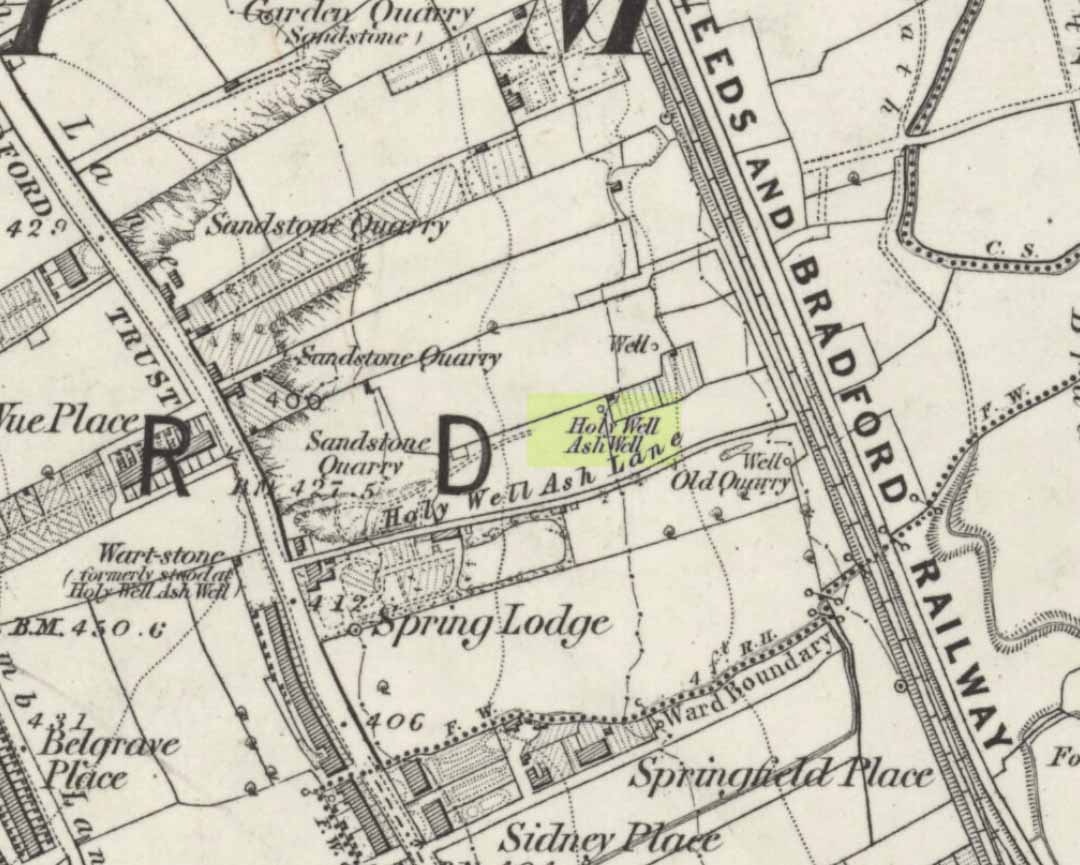
Holy Well Ash on 1852 map
Either right next to, or perhaps now beneath Bradford City’s Valley Parade football ground, was once a very important sacred well site. Known as the Holy Ash Well and variants thereof, this healing spring was of considerable renown to people all around Bradford district in bygone days. The site was illustrated on the 1852 OS map, and there was also a sacred stone adjacent to the well known as the Wart or Pin Stone, which had some animistic healing properties related the waters.
The old well was described by local historian Abraham Holroyd (1873) who said that:
“In Manningham Lane there is a fine well, in old deeds called Hellywell, i.e., holy well, in a field now called Halliwell Ash, now a stone quarry… Near this is the ancient Pin Stone.”
A few years later, in Robert Charles Hope’s (1893) monumental study, he described how,
“This holy well, not far from Manningham Lane, probably derived its name from having at some time been dedicated to some saint. The inhabitants of Bradford were wont in ancient times to resort on Sundays to these wells as a common place of meeting, to drink of the waters and partake of their preternatural virtues.”
Which was another was of saying that he didn’t really know too much about the place!
The Bradford historian William Preston (1933) described this site in one of his early essays, where he informed us that local people knew the accompanying rock hereby as the Ash Stone, due to its proximity and ritual relationship to a great old ash tree (Fraxinus excelsior) that grew next to the well. The mythic history of this particular tree should not be understated: it was a Creation deity par excellence in northern and Viking myths, but whatever old tales and power might once have been had here, in Bradford, they’ve long since been forgotten. But it was the industrial historian William Cudworth (1896) who told the most of this all-but forgotten site, saying:
“On the sloping ground between Belle Vue and the Midland Railway there once existed a spring of water, supposed to have preternatural virtues. The name it bore within present recollection is probably a corruption of Holy-well. The holy wells of England as elsewhere had not all the same virtues attached to them. Some were blessed if used for baptisms, to others were attributed curative properties, especially for sore or weak eyes, while others were supposed to possess mystical powers, insomuch as any article dipped in them became charms or safeguards against witchery. Any traditions associated with the spring at Halliwell (or Holywell) Ash are lost, but certainly in the early part of the present century the place was a favourite resort of the townspeople on Sundays.
“The derivation of the name is doubtful. In the survey of 1638 a close called ” Helliwell Ash” is mentioned as containing 2a. 3r. 26p., but without any indication as to its locality. The spelling of the name is of little moment. Mr. James, in his “History of Bradford,” states that he had seen the place referred to in old deeds as “Helly-well.” By his will, dated May, 1685, Thomas Lister, of Manningham, devised to his two daughters, Juliana Lambrecht and Elizabeth Stapleton, equal shares in two closes of land called “Holywell Ash” and ” Delf Close,” besides other lands in Manningham. In the will disposing of the possessions of Juliana Lambrecht, her moiety of “Holywell Esh” was bequeathed to Francis Stapleton, her nephew. In due course the lands in question were inherited by Francis Sharp Bridges, and have latterly belonged to Sir Francis Sharp Powell, M.P., in whose writings the form of spelling is given as ” Halliwell Ash.”
“Upon the ground in question there used to be a fine well of water issuing out of the higher ground, to which tradition assigned healing virtues. Might not the name of “holy” come from this circumstance? Sufficient importance attaches to the tradition, however, to have led the farmers of the recent ordnance plan of Manningham to preserve the name, although the widening of the Midland Railway below Thorncliffe Terrace has almost obliterated the site.”
A more recent updated overview of the site was written by one of my old school-mates, Dave Pendleton (1997), who said of the place:
“Prior to 1886 the only feature of any real note in the Valley Parade environs was a holy well that emerged near the corner of the football grounds Midland Road and Bradford End stands; hence the road Holywell Ash Lane. Today the site of the well is covered by the football pitch.
Only the road name survives as a reminder of what was apparently one of the district’s foremost attractions. On Sundays and holidays people would gather to take the waters and leave pins, coins, rags and food as offerings to the spirit that resided in the waters.
Accounts suggest that the well was covered and had a great ash tree standing over it (hence ‘holy ash’). There was also a standing stone called the wart stone of unknown antiquity. The stone had a carved depression that collected water. It was believed that the water was a miraculous cure for warts. Indeed, as early as 1638 the Holy Well had been credited with healing powers.
The well suffered a decline in popularity during the late nineteenth century and its keepers resorted to importing sulphur water from Harrogate, which they sold for a half penny per cup. The well disappeared under the Valley Parade pitch during the summer of 1886 and the wart stone was moved to the top of Holywell Ash Lane – which then ran straight up to Manningham Lane. The stone was still there as late as 1911 but thereafter it seems to have disappeared into the mists of time.”
A night-club adjacent to the Valley Parade football ground—called Bibby’s—was said to have had an old well in its cellar, which the owner of the place, Mr Pearl Gladstone Minott, said was ‘haunted’.
Unfortunately I’ve not been able to find any old photos or drawings of this lost holy well – though I imagine that some local, somewhere must be able to help us out with this one. Surely there’s more of this site hidden away somewhere….?
References:
Bennett, Paul, The Old Stones of Elmet, Capall Bann: Milverton 2001.
Cudworth, William, Manningham, Heaton and Allerton, W. Cudworth: Bradford 1896.
Holy Well (destroyed): OS Grid Reference – SE 295 329
Archaeology & History
In the Holbeck area of Leeds, one of the three spa wells was previously patronised to this mythical saint, whose wells profuse in this part of the world. St. Helen’s Well (later becoming the Holbeck Spa Well) was found at the appropriately named St. Helens Bridge. Ralph Thoresby (1715) wrote of the place: a supposed medicinal holy well, it previously had a chapel by it, of which no trace is seen today. John Mayhall (1860) also mentioned this “medicinal well,” but told little more. It was Andrea Smith (1982), more than a century later, who wrote the most about the place:
“In connection with the well by St.Helen’s Bridge, Holbeck, (Thoresby) refers to “another ancient fabrik called St. Helen’s,” but there is a difficulty in deciding exactly what he means by ancient; it is taken here as meaning more than two hundred years old. This suggests, then, that by St. Helen’s Bridge there was once a well and chapel which gave rise to the dedication and which was probably a Medieval foundation, considering the popularity of St. Helen at that time.”
Both of these sites have long since disappeared. The well eventually became known as a local Spa Well, and was found to possess a high sulphur content.
References:
Mayhall, John, The Annals of Yorkshire, Joseph Johnson: Leeds 1860.
Smith, Andrea, ‘Holy Wells Around Leeds, Bradford & Pontefract,’ in Wakefield Historical Journal 9, 1982.
Thoresby, Ralph, Ducatus Leodiensis: or the Topography of the Ancient and Populous Town and Parish of Leedes, Robinson & Holdsworth: Leeds 1816.
Go up through Baildon centre and head onto the moors. Crossing the cattle-grid, a coupla hundred yards further up, turn left. Past the small reservoirs on your left, another 100 yards or so and you reach the brow of the hill. As you begin going down the road, there’s a small car-park right by the roadside. The curious remains of the earthworks at the side of the old circle are discernible in the grassland right to its side.
Archaeology & History
Illustrated on the 6-inch OS-map of 1852 as “Site of a Barrow” (similar to how it appears in the image drawn here by Mr. C.N.M. Colls) a short distance below Pennythorn Hill top, there are still considerable traces of the earthworks surrounding the east and southern sides of what was once some form of ring cairn or tumulus that was once at this prominent place in the landscape.
Aerial view of siteThe site was first explored by Mr Colls in 1843 (his results were reported a few years later), who found a loose double-ring of stones, fifty feet across, surrounded by a shallow trench which was most notable on the south and east sides. Two urns were also uncovered near the centre of the ring, nearly two feet down, containing the cremated remains of people. A few years later, the Leeds historian James Wardell (1869) told a most fascinating note about what happened during their excavation, saying:
“This…examination was attended by a circumstance not soon to be forgotten by the persons engaged therein (on the excavation). They had almost reached the place where the broken urn and bones were deposited when, at once, such a fearful storm of thunder, lightning and rain came on, that they were not only considerably alarmed, but driven from the Common to seek shelter in the village.”
Colls’ 1846 sketch
We hear this sorta thing at many of our ancient places!
Colls 1846 plan
One anonymous writer in 1955 described the site as a ‘stone circle’, and a number of subsequent archaeologists copied this without question; but in all probability this site was more typical of an old cairn circle or ring-cairn, similar in size and design to the Roms Law circle two miles north of here. However, the earthworks at its side give the impression of some sort of exaggerated hengiform enclosure.
The place-name element howe strongly indicates a burial site and is a suffix found at many prehistoric tombs across northern England. The prefix ‘acre’ may relate to “a plot of arable or cultivated land, a measure of land (an acre) which a yoke of oxen could plough in a day” (Smith 1956), or may be a corrupted form of the Old English word, ‘acen’, relating to oak trees. Early literary examples of the place-name would enable a clearer understanding of the prefix element here.
References:
Anonymous, Colls’ Burial Mound Stone Circle, Baildon Moor, Museum Leaflets: Bradford 1955.
Baildon, W. Paley, Baildon and the Baildons (parts 1-15), St. Catherines: Adelphi 1913-26.
Barnes, Bernard, Man and the Changing Landscape, Eaton: Merseyside 1982.
Bennett, Paul, The Old Stones of Elmet, Capall Bann: Milverton 2001.
Colls, J.N.M., ‘Letter upon some Early Remains Discovered in Yorkshire,’ in Archaeologia, 31, 1846.
Collyer, Robert & Turner, J.H., Ilkley: Ancient and Modern, William Walker: Otley 1885.
Smith, A.H., English Place-Name Elements – volume 1, Cambridge University Press 1956.
Wardell, James, Historical Notes of Ilkley, Rombald’s Moor, Baildon Common, and other Matters of the British and Roman Periods, Joseph Dodgson: Leeds 1869. (2nd edition 1881)
The great Huddersfield historian, Philip Ahier (1948), in describing the lack of documentary evidence for several crosses in the neighbouring region, “at Deighton, Cowcliffe, Marsh and Golcar,” found out that,
“One did exist at Slaithwaite in front of the Manor House in the early past of the last century. In March 1931, the base of this cross, commonly known as the Dial Stone, was removed to Doughlas in the Isle of Man, where it rested in the garden of Mr Harry Wood; in August 1939, it was brought back to Slaithwaite and now stands in the Recreation Park.”
However, this site differs from another two that I’ve found records for on the outskirts of this township. Does anyone know what became of this old stone cross? Izzit still about? Its folk-name of the Dial Stone may make it a little easier to locate — but at the same time it does bring up the query, Why was it called that?
References:
Ahier, Philip, The Story of the Three Parish Churches of St. Peter the Apostle, Huddersfield – volume 1, Advertiser Press: Huddersfield 1948.
Dead easy. Take the A170 road from Pickering to Thornton-le-Dale and as you go into the large village, you’ll hit the old crossroads with the village green. Here be your cross!
Archaeology & History
Shown on the 1854 OS-map, I first came across a description of this old site in Creaser & Rushton’s (1972) scarce but lovely little work on the history of the old village here, where they told that,
“A cross has stood here since John de Eston in 1281 had the grant of a Tuesday market and two yearly fairs. It was repaired in 1820. Every year, the Abbot of Whitby unloaded 1500 red and 1500 white herrings here from his packhorse ponies for transhipment to the Master of St. Leonard’s Hospital at York.”
Or at least, that’s what he got folk to write down in the record-books! Close by were the old village stocks of the village (whose usage should be resurrected in many parts of this country nowadays).
References:
Creaser, A. & Rushton, J.H., A Guide and History of Thornton-le-Dale, Pickering, Yorkshire, E. Dewing: Pickering 1972.
This ‘hill of the big cairn’ is near the top end of the island, past the cup-marked stones of An Carn, just beneath the top of the prominent knoll, a half-mile east of the track. It’s about 200 yards from the summit on the southern side of the hill. More than 50 feet across and about 3 feet high, what may be kerb-stones can be seen on the west-side of the tomb. The Royal Commission (1984) lads tell us that,
“its northern edge is buried under field-gathered stones, and a small enclosure of comparatively recent date overlies the cairn.”
References:
Royal Commission on the Ancient & Historical Monuments of Scotland, Argyll: volume 5 – Islay, Jura, Colonsay and Oronsay, HMSO: Edinburgh 1984.
Travelling up (north) the A19, just as you get to Riccal village, there’s a small road to your right: take this! A mile along there’s a parking place just where the track veers into the woods. That’s where you’re heading. The remains of the tombs hereabouts can be hard to discern – but if your lucky you’ll either meet a local, or the virtue of patience will bring these overgrown tombs into focus! There are other tumuli a few hundred yards east and north of here aswell. If you wanna get a clear picture of them all, a full day would be a good bet!
Archaeology & History
Not to be confused with the other Danes Hills tombs a couple of miles northeast of here (as done on some other sites), the early Victorian geologist and explorer John Phillips (1853) was one of several early writers who described what, today, are known to be Iron Age tombs, scattered about a short distance east of Riccall village, saying:
“On Skipwith Common are many tumuli, old banks, and the slightly-marked foundations of ancient (turf or log?) houses or wigwams. These, by some error of tradition, are called ‘Danes’ Hills/ but, on opening the tumuli, no confirmation of so modern a date appeared. The tumuli are set in square fosses; the sides of the fossae range north and south and east and west (true). Similar facts appear in connexion with the tumuli on Thorganby Common adjacent. Burnt ashes and bones occur in the mounds; facts which suffice to overthrow the supposition of these hills being funeral heaps of the Danes of the llth century, for they then buried their dead. No instruments of metal, bone, or stone, or pottery were found.”
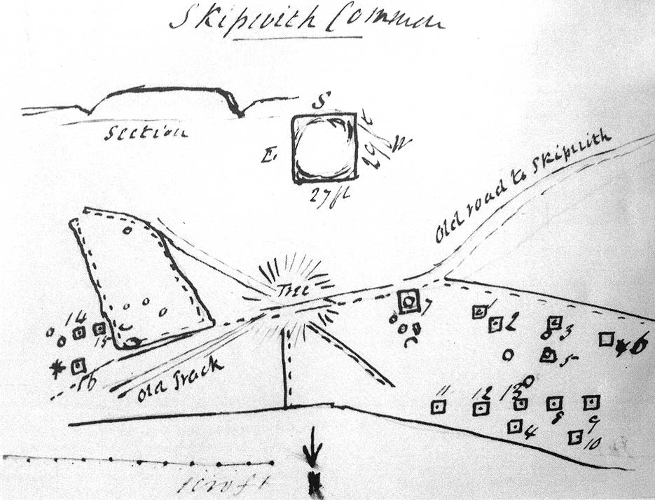
There were dozens of tombs that could be seen here in the past, but today many have been destroyed or are hidden by the cover of trees. A sketch-map (above) showing the rough location of many of the graves was made by the Yorkshire Antiquarian Club after a visit here in 1849 (Proctor 1855), who opened several of the barrows. Archaeologist Ian Stead (1961; 1979) defined these remains as being of the famous La Tene burials — though I’m unsure as to whether any of the tombs here had the great horse-chariots found in them, as found in the more famous Danes Graves tombs close to Driffield.
Folklore
The name of these small hills acquired their Danish title via a mix of real history and folklore. History tells of the old Danish King Harald Hardrada, who moored his fleet of ships a few miles away from here before going into battle against the armies of Northumbria and Mercia. “Dane’s Hill,” said Bogg (c.1895), “still marks the spot where the fight took place.” As John Burton (1758) told us:
“Ever since the aforesaid battle, it is by tradition to this day said, that the Danes were permitted to encamp here till they had buried their dead, and their ships at Riccal should be ready for their re-embarking for Norway.”
Local folk used to tell of the tradition of the local swamp — called Riccal Towdyke — being choked with the bodies of many slain in the battle hereabouts. Many pieces of red cloth were found all around in the neighbourhood of these tombs. However, despite this mix of fact and folklore, the tumuli were see marked on the modern OS-maps have been found to be Iron Age in origin.
…to be continued…
References:
Bogg, Edmund, From Eden Vale to the Plains of York, James Miles: Leeds n.d.
Burton, John, Monasticon Eboracense, N. Nickson: York 1758.
Elgee, F. & H.W., The Archaeology of Yorkshire, Methuen: London 1933.
Morrell, W. Wilberforce, The History and Antiquities of Selby, W.B. Bellerby: Selby 1867.
Phillips, John, The Rivers, Mountains and Sea-Coast of Yorkshire, John Murray: London 1853.
Proctor, W., ‘Report of the Proceedings of the Yorkshire Antiquarian Club, in the Excavation of Barrows from the Year 1849,’ in Proceedings of the Yorkshire Philosophical Society, 1855.
Stead, I.M., ‘A Distinctive Form of La Tene Barrow in Eastern Yorkshire,’ in Antiquaries Journal, volume 41, 1961.
Stead, I.M., The Arras Culture, Yorkshire Philosophical Society: York 1979.
Having not been here, I can’t say for sure exactly where this forgotten site happens to live! It may be the one shown on modern OS-maps, behind the old post office, on the west-side of the village, but I aint sure. If any local people out there who can help us, we would be hugely grateful!
Archaeology & History
Not to be confused with the other St. Michael’s Well a few miles away in the village of Well, this is a little-known holy well that was described by the historian H.B. McCall (1910), who wrote:
“As Burneston had Saint Lambert’s Fountain, mentioned so early as the 12th Century, so Kirklington possesses its holy well, beside the old Mill House on the north side of the village. Althoguh its name has now passed from the popular remembrance, it is provided in a lease of lands to Roger Croft, in 1628, that his cattle shall have right of access to go into the water near unto a spring called ‘Michaell-well’. both in winter and summer; and we are left in no doubt as to where the spring was situated, for Mrs Alice Thornton has recorded that her father brought water to the Hall in lead pipes from a cistern of the same metal, “near St. Michael’s Well near the mill-race.””
Does anyone know anything more of this all-but-forgotten site?
A short distance to the north in the same village, another sacred water source known as the Lady Well can also be found.
References:
McCall, H.B., Richmondshire Churches, Elliott Stock: London 1910.
Found near the bottom of Holly Hill, as Graeme Chappell tells us, this old site “is located by the side of a narrow lane on the west side of the village of Well (aptly named). The OS map places the well on the north side of the lane, but this is only the outflow from a pipe that carries the water under the road. The spring actually rises at the foot of a small rock outcrop, on the opposite side of the road.”
Archaeology & History
St. Michael’s Well, Well (Bogg 1895)
Although the village of Well is mentioned in Domesday in 1086 and the origin of the place-name derives from “certain springs in the township now known as The Springs, St. Michael’s Well and Whitwell,” very little appears to have been written about this place. Edmund Bogg (c.1895) wrote that an old iron cup — still there in the 19th century — was attached next to this spring for weary travellers or locals to partake of the fine fresh water. Nearby there was once an old Roman bath-house and, at the local church, one writer thinks that the appearance of “a fish-bodied female figure…carved into one of the external window lintels” is representative of the goddess of these waters. Not so sure misself — but I’m willing to be shown otherwise.
Folklore
Around 1895, that old traveller Edmund Bogg once again wrote how the villagers at Well village called this site the Mickey or Mickel Well,* explaining: “the Saxons dwelling at this spot reverently dedicated this spring of water to St. Michael.” A dragon-slayer no less!
Although not realising the Michael/dragon connection, the same writer later goes on to write:
“There is a dim tradition still existing in this village of an enormous dragon having once had its lair in the vicinity of Well, and was a source of terror to the inhabitants, until a champion was found in an ancestor of the Latimers, who went boldly forth like a true knight of olden times, and after a long and terrible fight he slew the monster, hence a dragon on the coat of arms of this family. The scene of the conflict is still pointed out, and is midway between Tanfield and Well.”
This fable occurred very close to the gigantic Thornborough Henges! It would be sensible to look more closely at the mythic nature of this complex with this legend in mind. A few miles away in the village of Kirklington, the cult of St. Michael could also be found.
References:
Bogg, Edmund, From Eden Vale to the Plains of York, James Miles: Leeds n.d. (c.1895)
Smith, A.H., The Place-Names of the North Riding of Yorkshire, Cambridge University Press 1928.
* In old english the word ‘micel‘ (which usually accounts for this word) means big or great. On the same issue, the ‘Holly Hill’ in the case here at Well actually derives from the holly tree and NOT a ‘holy’ well. However, check the folklore of this tree in Britain and you find a whole host of heathen stuff.