Thornborough Cursus, North Yorkshire

Cursus Monument:  OS Grid Reference – SE 286 794

Archaeology & History

In the midst of the great henge monuments at Thornborough — specifically, the central henge — archaeologist Ian Longworth (1965) said there “was built …a still earlier structure known as a cursus.”  This giant monument was one of the earlier such sites located in Britain.  Longworth continued, saying:

“This was a ceremonial avenue, running for nearly a mile in a northeast / southwesterly direction.  The avenue is defined by ditches 144 feet apart with a bank running along the inside of each ditch.  The ditches are now completely filled with plough soil and, as with other cursus monuments in the county, were discovered from the air as two dark lines in the cereal crop… Probably used for ritual ceremonies, no clues remain to show what actually took place.”
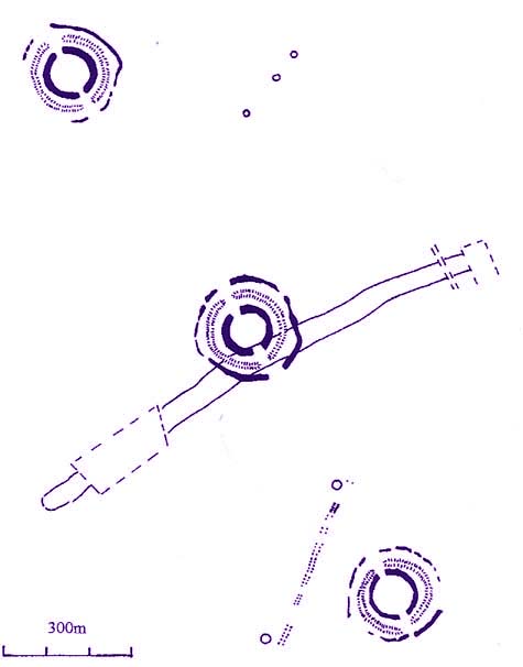
Thornborough Cursus (& henges)

This cursus runs almost at right angles to the alignment of the three Thornborough Henges, on the southern side of the central henge, and was first found through the aerial photography of J.K. St. Joseph between 1945 and 1952. When excavation work was carried out, “a crouched burial was found in a stone cist within the southwest end” of the cursus.  This end of the monument is rounded, like the Stonehenge Cursus; whilst the northeast end of the monument has not been located. The southwest end of the cursus begins at OS grid-reference SE 2799 7906 and its northeasterly end is roughly at SE 2881 7954.  The middle of the known cursus is roughly in Thornborough’s central henge.

Paul Devereux (1989) said that the monument, “which had become silted-up and grass-covered by the time the henge was built, had two main orientations, with a curvilinear, irregular section just to the east of the henge.”  Although Norris Ward (1969) thought that the cursus actually went all the way down the River Ure, it stops some distance beforehand, though may obviously have had some important relationship with the waters.

It seems that other cursus monuments have been found close by the henges more recently.  More about them in the near future, hopefully…

…to be continued…

References:

  1. Longworth, Ian H., Regional Archaeologies: Yorkshire, Cory, Adams & Mackay: London 1965.
  2. Pennick, N. & Devereux, P., Lines on the Landscape, Hale: London 1989.
  3. Thomas, Charles, ‘Folklore from a Northern Henge Monument,’ in Folklore Journal, volume 64:3, 1953.
  4. Ward, Norrie, Yorkshire’s Mine, J.M. Dent: London 1969.

© Paul Bennett, The Northern Antiquarian

St. Michael’s Well, Well, North Yorkshire

Holy Well:  OS Grid Reference – SE 2633 8176

Also Known as:

  1. Mickel Well
  2. Mickey Well

Getting Here

Found near the bottom of Holly Hill, as Graeme Chappell tells us, this old site “is located by the side of a narrow lane on the west side of the village of Well (aptly named). The OS map places the well on the north side of the lane, but this is only the outflow from a pipe that carries the water under the road.  The spring actually rises at the foot of a small rock outcrop, on the opposite side of the road.”

Archaeology & History

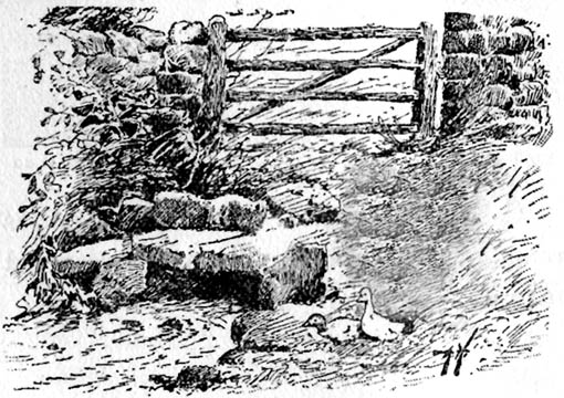
St. Michael's Well, Well (Bogg 1895)
St. Michael’s Well, Well (Bogg 1895)

Although the village of Well is mentioned in Domesday in 1086 and the origin of the place-name derives from “certain springs in the township now known as The Springs, St. Michael’s Well and Whitwell,” very little appears to have been written about this place.  Edmund Bogg (c.1895) wrote that an old iron cup — still there in the 19th century — was attached next to this spring for weary travellers or locals to partake of the fine fresh water.  Nearby there was once an old Roman bath-house and, at the local church, one writer thinks that the appearance of “a fish-bodied female figure…carved into one of the external window lintels” is representative of the goddess of these waters.  Not so sure misself — but I’m willing to be shown otherwise.

Folklore

Around 1895, that old traveller Edmund Bogg once again wrote how the villagers at Well village called this site the Mickey or Mickel Well,* explaining: “the Saxons dwelling at this spot reverently dedicated this spring of water to St. Michael.” A dragon-slayer no less!

Although not realising the Michael/dragon connection, the same writer later goes on to write:

“There is a dim tradition still existing in this village of an enormous dragon having once had its lair in the vicinity of Well, and was a source of terror to the inhabitants, until a champion was found in an ancestor of the Latimers, who went boldly forth like a true knight of olden times, and after a long and terrible fight he slew the monster, hence a dragon on the coat of arms of this family. The scene of the conflict is still pointed out, and is midway between Tanfield and Well.”

This fable occurred very close to the gigantic Thornborough Henges!  It would be sensible to look more closely at the mythic nature of this complex with this legend in mind.  A few miles away in the village of Kirklington, the cult of St. Michael could also be found.

References:

  1. Bogg, Edmund, From Eden Vale to the Plains of York, James Miles: Leeds n.d. (c.1895)
  2. Smith, A.H., The Place-Names of the North Riding of Yorkshire, Cambridge University Press 1928.

* In old english the word ‘micel‘ (which usually accounts for this word) means big or great. On the same issue, the ‘Holly Hill’ in the case here at Well actually derives from the holly tree and NOT a ‘holy’ well. However, check the folklore of this tree in Britain and you find a whole host of heathen stuff.

© Paul Bennett, The Northern Antiquarian