Dunruchan ‘A’ Standing Stone, Muthill, Perthshire

Standing Stone: OS Grid Reference – NN 79555 17388

Also Known as:

  1. Aodann Mhor
  2. Cornoch
  3. Shillinghill

Getting Here

The giant Dunruchan A stone

From Comrie town centre take the road south across Dalginross Bridge over the river, heading towards Braco, up the winding B827 road for 2-3 miles until you reach a small crossroads (you can easily miss it, so watch out!). Turn left and, about a mile on, 100 yards or so before Craigneich Farm (near its lovely standing stone), go up the track on your right up the hills. Follow the track up and through the gate, then walk straight uphill. A coupla hundred yards up you’ll see a large standing stone on the flat grassy plain to your left. That’s Dunruchan A.

Archaeology & History

Dunruchan A, looking east

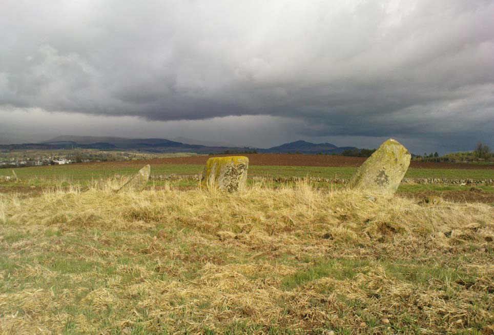
This is a magnificent stone in a magnificent landscape, no doubt of considerable mythic importance to the people who lived and erected it several thousand years ago. It is the tallest of at least six standing stones to be seen on this section of moorland and  stands out on the hillside from various angles as you walk the hills and glens around here: an element that was, no doubt, intended by those who built it.  It’s probably a very old standing stone, more likely neolithic in origin than the generally ascribed Bronze Age.

The great stone in the sky
Dunruchan A, and its heathen onlooker

Standing on the flat grassy plain above Shillinghill and Craigneich, it is surrounded by many small cairns and, it would seem, was once accompanied by a cairn of its own if the scatter of small rocks around its base is anything to go by (though I’m not aware of any detailed excavations here by antiquarians, so this initial assumption may be wrong). Indeed, it seems the Dunruchan A stone stands in the middle of a scattered prehistoric cemetery if the many small overgrown piles of rocks are anything to go by: though I know of no detailed account of these many scatterings of stones (anyone know if they’re ancient, or field clearances?).  However, the great megalith hunter Fred Coles (1911) did comment on how this and the other giant standing stones nearby may “commemorate burials,” but didn’t explore the idea any further.

Approaching twelve feet tall, it was Cole (1911) who described this huge standing stone in one of his essays on the Perthshire megaliths, telling:

“Dunruchan Moor stretches, at a general height of about 700 feet above sea-level, for nearly two miles towards the south and south-west of Craigneich. At its northern extremity, and distant from the Craigneich Stone about 610 yards, stands the first and the tallest of the group (A on the plan), a huge pointed mass of conglomerate schist, its apex being 11 feet 4 inches above ground. Its base is a somewhat regular oblong, measuring along the north and south faces 4 feet 2 inches, and across the edges 3 feet 10 inches and 2 feet 2 inches, the wider of these being on the east. Small and insignificant boulders lie loosely around it. The smoothest and most vertical side faces the north. The illustration (fig. 16A) was drawn from the east, with the Aberuchil Hills as a background.”

Fred Coles’ 1911 drawing

From this great stone, looking west across the moors the giant standing stone of Dunruchan C and its companions can be noticed just a few hundred yards away.  A cup-marked stone can also be seen about 200 yards west of here. It has been suggested that this and the other standing stones were part of some curious megalithic stone row (Burl 1993; Thom 1990), but this seems most unlikely.  Thom made no notes of the archaeoastronomical potential at Dunruchan A, nor its associates.

As a megalithic complex, this area is outstanding.  The other large standing stones of Dunruchan D and Dunruchan E are on the moorland plain a few hundred yards to the southwest and must be visited if you explore the area.  This is serious megalith country!

Folklore

According to an account in the Ordnance Survey Name Book of 1860, “these stones are believed to mark the graves or commemorate the death of Roman soldiers who fell in a battle fought here between the Romans and the Caledonians.”

References:

  1. Burl, Aubrey, From Carnac to Callanish, Yale University Press 1993.
  2. Cole, Fred, “Report on Stone Circles in Perthshire, Principally Strathearn,” in Proceedings of the Society of Antiquaries, Scotland, volume 45, 1911.
  3. Finlayson, Andrew, The Stones of Strathearn, One Tree Island: Comrie 2010.
  4. Hunter, John, Chronicles of Strathearn, David Phillips: Crieff 1896.
  5. Thom, A., Thom, A.S. & Burl, Aubrey, Stone Rows and Standing Stones – 2 volumes, BAR: Oxford 1990.

ACKNOWLEDGEMENTS: Many thanks to Paul Hornby for use of his photos!

© Paul Bennett, The Northern Antiquarian


Hawk Hill, Alloa, Clackmannanshire

Stone Circle (destroyed): OS Grid Reference – NS 906 925

Archaeology & History

Clump of trees near the site of the olde circle…

This is another megalithic ring that appears to have been destroyed, sometime around 1923. It was one of a series of very important Bronze Age monuments that could once be seen along the ridge of Hawk Hill on the eastern outskirts of Alloa. A series of important prehistoric tombs scattered the area, and a tall early medieval cross was erected near the site to try christianize this important heathen arena. Sadly, we have few details available of the circle itself. The Royal Commission (1933) report simply said of it:

“This circle occupied a site immediately behind the lodge at the eastern extremity of the same (ridge) as the cairn (on Hawk Hill). It was, we are informed, entirely removed about ten years ago.”

In the cultivated field there is a curious circular clump of trees which I thought might harbour some of the fallen monoliths, but a scattering of overgrown stones within them did not have that prehistoric pedigree about them.  Perhaps better luck might be had in the trees at the end of the field…  The tall Hawk Hill Cross can be seen just a couple of hundred yards or so immediately to the west.

References:

  1. Royal Commission on Ancient & Historical Monuments, Scotland, Fife, Kinross and Clackmannan, HMSO: Edinburgh 1933.

© Paul Bennett, The Northern Antiquarian 


Gleneagles Stone Circle, Blackford, Perthshire

Stone Circle (lost):  OS Grid Reference – NN 93 08

Also Known as:

  1. Canmore ID 25929

Archaeology & History

Virtually nothing is known of a stone circle that was described in the 18th century old Statistical Account of Scotland, where a ring of stones was seen “in the parks of Gleneagles.”  Its exact whereabouts remains unknown and the grid-reference given for the circle is an approximation.  The writer told that this was “supposed to have been places of Druidical worship,” and it is mentioned alongside the megalithic sites at nearby Sheriffmuir and the Glebe.

The circle is mentioned without further details on the Canmore website.  A number of stones above St. Mungo’s Well looked promising when I was bimbling in the area the other week — and as the landscape levels out above the well towards Glen Devon, we have a promising panorama, but there was nothing there.  It would be good to have a team of us bimbling round here to see what could be found.  However, the site may well have been destroyed.  Any further information about this site would be hugely welcome!

References:

  1. Sinclair, John, The Statistical Account of Scotland, 1791-1799 – volume 3, EP: Wakefield 1979.

© Paul Bennett, The Northern Antiquarian


Gleneagles ‘A’, Blackford, Perthshire

Standing Stone:  OS Grid Reference – NN 9211 0962

Also Known as:

  1. Blackford
  2. Loaninghead
  3. Peterhead Farm

Getting Here

Monolith nr Peterhead Fm

Along the A9 dual carriageway between Blackford and Auchterarder, take the A823 road south, up the Glen Eagles road as if you’re heading towards Pool of Muckhart and Dunfermline.  Less than 100 yards up the road, turn immediately right and go past the standing stone of Gleneagles B for a coupla hundred yards or so, where there’s a left turn (down to Peterhead Farm).  Stop here and look into the field in front of you.  You can’t really miss it!

Archaeology & History

Gleneagles ‘A’, gazing west

This short standing stone, more than 3ft tall, has an elegance about it which megalith lovers alone will understand!  Maybe it’s the setting; maybe the feel of the land; or maybe something else.  I dunno… On my first visit to the site, Nature was wearing a grey overcast cloak, but the site and I didn’t seem to care; and although the view from here doesn’t have the same grandeur of Glen Eagles to view as its companion stone a few hundred yards to the east might have, there felt a greater welcoming at this smaller stone.  Odd, considering this monolith had been knocked over and re-positioned by the farmer in the not-too-distant past.  Anyway…less of this subjective nonsense of feelings from the landscape and megaliths!  Utter drivel all of it!

The earliest measured account of the stone is to be found in Mr Hutchison’s (1893) essay, where he notes this and its companion close by, giving us the dimensions of this monolith:

“This (stone) is roughly columnar in shape, but wider at the base than above. Its height is 3ft above ground; circumference at base 6ft. 5in., diminishing to 4ft. 2in at the top. It is of metamorphic schist.  The line of direction between these two gives a horizontal angle of 260°.”

Since that day, in the mass of archaeology essays that have been scribed, this smoothed upright gets only a minimal description.  Charles Calder’s (1947) account is typical, saying simply that it is,

“Somewhat cylindrical in form with a girth of 7 feet at the base, it rises with a decided tilt towards the west to a height of 3 feet 10 inches above ground-level.”

The stone fares better in Andrew Finlayson’s (2010) fine local survey of megalithic ruins, where he points out that this and its compatriot stone Gleneagles B, are in an alignment with the fallen Boat Stone and the upright White Stone, a few miles to the southwest.  This line works on 1:50,000 map, but when transferred to larger-scale surveys, the alignment misses each outlying site by 20-30 yards here and there.

References:

  1. Calder, Charles S.T., “Notice of Two Standing Stones (one with Pictish Symbols) on the Lands of Peterhead Farm, near Gleneagles, Perthshire,” in Proceedings of the Society of Antiquaries, Scotland, volume 81, 1947.
  2. Feachem, Richard, Guide to Prehistoric Scotland, Batsford 1977.
  3. Finlayson, Andrew, The Stones of Strathearn, One Tree Island: Comrie 2010.
  4. Hutchison, A.F., “The Standing Stones of Stirling District,” in The Stirling Antiquary, volume 1, 1893.

© Paul Bennett, The Northern Antiquarian


Cairnwochel, Ardoch, Perthshire

Chambered Cairn (destroyed):  OS Grid Reference – NN 830 127

Archaeology & History

References to this site are few and far between.  I wandered past the place the other day on my way back from the megaliths of Dunruchan and Comrie without knowing anything about the place; but was, for some reason, drawn up the grassy hill slope towards the forestry plantation, where the scattered old walling implied (to me at least) the presence of some old prehistoric ruin… But as the daylight hours were fading, I had to head for home, wondering what it was that was pulling my nose to this place I’d never visited before.

The following day when I was searching for information about the prehistoric archaeology of the area, I came across Audrey Henshall’s (1972) description of some giant cairns that once stood here, upon the hilltop – exactly where my nose had led me!  Sadly however, they have been all-but destroyed.

At least two prominent prehistoric cairns were to be found in relative proximity to each other hereby, each with their own name.  The site was first described in A. Gordon’s 1726 work, Itinerarium Septentrionale, where he wrote the following:

“On the hill above the moor are two great heaps of stones, the one called Cairnwochel, the other Cairnlee: the former of these is the greatest curiosity of its kind that I ever met with; the quantity of great rough stones lying above one another almost surpasses belief, which made me have the curiosity to measure it, and I found the whole heap to be about 182 feet in length, 30 in sloping height, and 45 in breadth at the bottom.  That at Cairnlea is not near so considerable as the former.”

Nearer to the end of the 18th century, Cairnwochel was mentioned again – this time in the Old Statistical Account (1793), where a description was given of some dig into the giant cairn, to see what lay beneath the mass of rocks.  The report told that,

“there was found a stone coffin, in which there was a skeleton 7 feet long.  The cairn lay from north to south and the coffin was nearly in the middle of it, with the head to the east. Most of the stones have been carried away to inclose the neighbouring farms; but the coffin, with a few large stones around it, has, by the order of Sir William Stirling, been preserved.”

When Miss Henshall explored the site in the 1960s, she found very little left of this once superb tomb, simply, “the only sign of any structure (were) a few laid stones on its S side, possibly part of a revetting wall-face.”

The sheer size of the cairn implies that it was probably Neolithic in origin (its description reminded me of the King’s and Queen’s Cairns near Skipton, Yorkshire).   We have hardly any information about the nearby Cairnlea site.  The intrusion of the forestry commission here has probably covered over a number of other important Neolithic and Bronze Age remains, but if anyone has further information on this site it would be hugely welcome.

References:

  1. Henshall, Audrey, The Chambered Tombs of Scotland – volume 2, Edinburgh University Press 1972.

© Paul Bennett, The Northern Antiquarian


Glenhead Stone Row, Doune, Stirlingshire

Standing Stones: OS Grid Reference – NN 75491 00455

Also Known as:

  1. Canmore ID 24689

Getting Here

Take the B824 road that runs between Dunblane and Doune and, whichever direction you’re coming from, watch out for the large statue of David Stirling by the roadside (y’ can’t really miss it!).  Stop here. Then, walk along the dirt-track into the field by the side of the statue, keeping your eyes peeled 50 yards along, for the upright stones in the field on your right, at the top of the brow of the hill.

Archaeology & History

Glenhead Farm standing stones

A few hundred yards south of the large Glenhead Standing Stone, we come across this curious small row of three reasonably large standing stones which — the more you look at them — give the distinct impression that they may be the remains of a large prehistoric tomb.  But archaeology records are silent on this matter and we must contend with what we can see.  At the northernmost end of the row, a fourth stone lays amongst the vegetation: it may have once stood alone, or maybe  been snapped from  its fellow monolith.  20 yards south is a large mass of stone; perhaps from an old building, perhaps cairn spoil (does anyone know?)

The local historian Moray Mackay (1984) thought that the line of stones here were once a part of something larger, saying:

“Originally it was probably a circle of six stones, with a seventh in the middle, and this central stone can still be identified by its flat top on which are the mysterious and well known cup-marks, much weathered but plainly visible.  Close to the site, urns and stone hammers were unearthed last century.”

Glenhead stone row, looking north

Of the three remaining upright stones, it is the central one which has the cup-markings visible on its top and side (Allen 1882), with a lovely covering of almost luminous lichen giving it extra effect! (a separate TNA Site Entry for the cup-marked stone will be written in due course)

The famous astroarchaeologist Alexander Thom and his son (1990) described the place as,

“A three stone alignment showing about 33° N declination in one direction and 31° S in the other, but the azimuth comes from the stones only and so cannot be accurate. Perhaps the line is lunar to the hill in the SW…”

In Thom’s (1967) earlier work he posited that the alignment may relate to the rising of the star Capella around 1760 BC, but this is untrue. Thom’s error however, was not of his making, but due to the false dates that archaeologists ascribed to megalithic ruins at the time – dates which Thom used in his research, believing that the archaeological fraternity would know what they were talking about!  In their collaborated text, Aubrey Burl added how,

“these stones stand on a hill summit at 360ft (110m) OD. The row is on a north-facing slope. Three stones stand. A fourth, prostrate, 6ft 6 in (2m) long, lies against the NE pillar. The row has a NNE-SSW axis. The northernmost stone is 3ft 6in high, the centre 4ft, and the SSW, characteristically the tallest, 6ft 6in… The line is about 27 feet (8.3m) long. The central stone has 23 cupmarks on its top and 4 more on its western side.”

…to be continued…

References:

  1. Allen, J. Romilly, “Notes on some Undescribed Stones with some Cup-Markings in Scotland,” in PSAS 16, 1882.
  2. Burl, Aubrey, From Carnac to Callanish, Yale University Press 1993.
  3. Mackay, Moray S., Doune: Historical Notes, Forth Naturalist: Stirling 1984.
  4. Thom, Alexander, Megalithic Sites in Britain, Oxford University Press 1967.
  5. Thom, A., Thom, A.S. & Burl, A., Stone Rows and Standing Stones – volume 2, BAR Oxford 1990.

© Paul Bennett, The Northern Antiquarian


Lady’s Well, Tillicoultry, Clackmannanshire

Holy Well:  OS Grid Reference – NS 91105 97510

Also Known as:

  1. Ladies Well
  2. Our Lady’s Well

Getting Here

The old spring of Lady’s Well

From the main road running through the town, head west towards Alva, and where the golf course begins, take the footpath uphill at its edge which heads towards the giant quarry.  Where the dirt-track begins, keep walking along the edge of golf course, noting that where the open field starts, a gate on your right.  Go through this, and walk up the side of the fence for some 30 yards, then go through the large gate.  10 yards in front of you, note the small stream crossing the track, and a scatter of overgrown rocks just on the other side of the wire fence. You’re here!

Archaeology & History

Thought by Angus Watson (1995) to have been possibly dedicated to ‘Our Lady’: in this context it’s difficult to know whether the dedication was to the christian Virgin, or to the heathen ‘Lady Alva’, whose web of snow and other natural garments clothe the mountains and glens of the Ochils hereby.

The first account of the place seems to be in William Gibson’s Reminiscences (1883) where he told that,

“In the year 1839, a Mr John Henderson built the only woollen mill…the water for the steam engine of which was got from the Ladies Well”,

Ladys Well on 1899 map

which was barely 100 yards to the west.  It was later highlighted on the OS-map in 1899 with an associated ‘fountain’, right by the track-side.  A water-pumping station shown at the same time on another map was, of course, the one that was built to supply the mill with water.

The present water source is slightly higher in the field than when it was shown on the early OS-maps, and it does still flow continuously—although the source is much neglected and could do with being recovered: as the photo here shows, an ugly pipe appears to be taking much of the healing waters which are now mainly feeding a large pond in the garden just below.

References:

  1. Gibson, William, Reminiscences of Dollar and Tillicoultry, Andrew Elliot: Edinburgh 1883.
  2. Watson, Angus, The Ochils: Placenames, History, Tradition, Perth & Kinross Libraries 1995.

© Paul Bennett, The Northern Antiquarian


Buck Woods Carving (01), Thackley, Bradford, West Yorkshire

Cup-Marked Stone:  OS Grid Reference – SE 17456 39155

Getting Here

One of the Buck Woods carvings
One of Buck Woods carvings

From Thackley corner, take the Esholt road down Ainsbury Avenue.  After a couple of hundred yards, note the metal gateways into the woods.  Go through here, following the main path, until you reach another split in the paths where one of those awful touristy signs tells you where you are.  Walk past this (not left or right) into the opening of large oaks and other trees on a flat plain.  A path swings round the right side of this, and less than 100 yards along, watch out for some rocks on your right, heading towards the wall and small field.  You’re damn close!

Archaeology & History

Close-up of cup-markings

This is one amongst a cluster of at least five cup-marked stones very close to each other in the woods here — and probably the best of the bunch.  Also found in conjunction with what seems to be an Iron Age walled enclosure 20 yards away, there are at least eight cup-marks on top of this rock,  They occur in two groups: one, on a sloping section of the boulder where three fading cups can be seen; and the other is on the topmost section of the stone, where five larger cups distinctly stand out, and occur in conjunction with what seems to be a long carved line running close to the edge of the rock before it drops sharply to the ground.

This and its associated carvings are found in close proximity to some sort of walled enclosure.  It’s difficult ascertaining the age and nature of the enclosure walling, as masses of it are found throughout this section of woodland and it appears to be multiperiod in age and nature: from Iron Age to Victorian by the look of things.  Neither this cup-marked stone, nor any of its close associates (the closest of which is the Buck Woods 3 carving, less than 10 yards away), were recorded in the Boughey & Vickerman survey of rock art in West Yorkshire.

© Paul Bennett, The Northern Antiquarian


Chair Stone, Burley Moor, West Yorkshire

Cup-Marked Stone:  OS Grid Reference – SE 14395 45222

Getting Here

Cupmarked stone west of Coldstone Beck

Fom Burley train station, take the road uphill onto the moor edge, turning right for a coupla hundred yards where the road runs up the side of the Coldstone Beck. Walk up the stream until you hit the footpath that takes you onto the moor proper, on the righthand (west) side.  Once on the level, note scatter rocks on the near horizon above you and the faded track that runs up towards them. Walk up here, keeping your eyes peeled for the small chair-shaped rock immediately left of the pathway. You can’t really miss it.

Archaeology & History

One of an increasing number of carvings that I’m finding have curiously not been included in the general rock art surveys of the region (Boughey & Vickerman, 2003; Hedges 1986).  We first found this—Jon Tilleard and I—when we were foraging for such carvings in the 1970s and early ’80s and the scruffy drawing here is taken from one of my early notebooks (1981) that explored the archaeological remains on these moors.

Scruffy drawing of the stone, c.1982
Close-up of cup-marks

The name of the stone comes from the slightly chair-like shape of the rock on which the blatantly obvious cup-markings can be seen.  There are at least six of them, with a possible seventh near the top of the rock.  Some curious eroded markings can still be to the left-side of the main cups, but I’m unsure as to their nature and they may be just geophysical. Above and around this rock are a number of medieval pit workings, quarrying and scatterings of other rocks, none of which have been found to possess cup-and-rings.

References:

  1. Bennett, Paul, Of Cups and Rings and Things, unpublished: Shipley 1981.

© Paul Bennett, The Northern Antiquarian


Acrehowe Cross, Baildon Moor, West Yorkshire

Cross (destroyed):  OS Grid Reference – SE 14390 40601

Also Known as:

  1. Rerehowe Cross

Archaeology & History

‘Rerehowe’ cross on 1852 map

Once found on the other side of the road from the prehistoric circle of Acrehowe Hill, this old cross was destroyed sometime in the first half of the 19th century by one of the stewards to the Lady of the Manor of Baildon, a Mr Walker.  It’s unlikely that Mr Walker would have performed this act without direct orders from the Lady of the Manor, so the destruction should really be laid at the feet of the land-owner, who’ve got a habit of destroying archaeological sites up and down the land, even today.

Found near the crown of a small hill on the horizon whether you’re coming from Eldwick- or Baildon-side, the cross was erected (probably between the 12th and 14th centuries) amidst a cluster of heathen burials and cup-and-rings, many of which would have been known by local peasants as having old lore or superstitions about them.  So the church commandeered this spot, desacralized it and no doubt enacted profane rites around it under the auspice of some spurious christian law.  They did that sorta thing with every non-christian site they ever came across—or simply vandalised it, much as many of them still do today.  Sadly we know not the exact history of the old cross: whether it was an old standing stone on the crown of this hill which they defaced and made into a cross, or whether they erected their own monument, we’ll never know.  But the idea of a once-proud monolith standing here is a strong possibility, considering its position in the landscape and the stone rings of Pennythorn and Acrehowe close by (cup-and-ring stones such as carving no.184 are also close by).

The cross itself once gained an additional incorrect title by the cartographers of the period, who named it Rerehowe Cross—but this was simply a spelling mistake and its newly-found title didn’t last long. The local industrial historian William Cudworth (1876) described the lost cross in his large work, where he told that,

“many of the inhabitants can remember and point out the exact spot where it stood, and no doubt could find some of the stones of which it was composed. It was destroyed by one of the overseers and a large portion of it used for fence stones.”

Harry Speight (a.k.a. ‘Johnnie Gray’) and others also mentioned the passing of this old stone, but give no additional information.

Folklore

In William Cudworth’s description of this site he told how “the village tradition is that it was put up in commemoration of a great battle that was fought on the Moor” at Baildon; but W.P. Baildon (1913) thought this was unlikely.  Instead, he cited an 1848 Name Book reference dug out by W.E. Preston, which told that on the summit of Acrehowe Hill,

“Here stood a cross which, according to traditional evidence was erected at the period that markets were held at Baildon, in consequence of a plague which prevented the country people from visiting the village with provisions, etc.  The site of its base is very apparent, being circular, about 8 feet in diameter.  A large flag stone  with the stump of the cross remaining in its centre, was pulled up and destroyed by Mr Walker (Baildon Hall) a few years since.”

References:

  1. Baildon, W. Paley, Baildon and the Baildons (parts 1-15), St. Catherines: Adelphi 1913-26.
  2. Bennett, Paul, The Old Stones of Elmet, Capall Bann: Milverton 2001.
  3. Colls, J.M.N., ‘Letter upon some Early Remains Discovered in Yorkshire,’ in Archaeologia, volume 31, 1846.
  4. Cudworth, William, Round about Bradford, Thomas Brear: Bradford 1876.
  5. Gray, Johnnie, Through Airedale from Goole to Malham, Walker & Laycock: Leeds 1891.

© Paul Bennett, The Northern Antiquarian