Whether you’re coming here from Wrose or Eccleshill, go along Wrose Road and turn down Livingstone Road at the traffic lights. Down here, when the road splits, head to your right until you meet with those stupid road-block marks (where you can only get one car through). Just here, walk down the slope and path on your right, and before you hit the bottom of the slope, walk down the small valley for about 20 yards until you see the small stream appear from beneath some overgrown man-made stone lintels. That’s it!
Archaeology & History
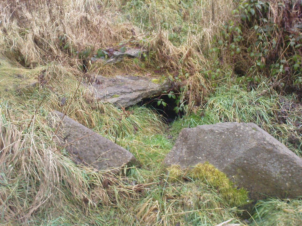
When I was a kid I used to play down this tiny valley when the waters here still had small fish swimming away (we used to call them ‘tiddlers’). The fish seem to have gone, but there are still waterboatmen on the surface, indicating that we still have fresh water here – and on my most recent visit, I cautiously tasted the waters and found them OK (the prevalence of broken bottles and beer cans from locals doesn’t inspire you to drink here though).
Initially located on the local boundary line between Eccleshill and Wrose, the waters used to be found running into a trough about 100 yards further up the small valley, but this has been lost and housing now covers its original site. You can see how the stream has cut the valley further upstream, but now it bubbles up from beneath the rocks shown in the photo. Bradford historian Robert Allen (1927) described the site in his survey as originally being between North Spring and South Spring Wood.
Although the name Sweet Willy Well remains a mystery, one of its other titles — the Lin Well — relates to the presence of linnets that used to be found in great numbers here. The ‘Sugar Stream’ name is one we knew it as locally as children, due to the once sweet taste of the waters. It is likely to have had medicinal properties, but these have been forgotten. No archaeological survey has ever been done of this site.
References:
Allen, Robert C. (ed.), The History Of Bolton In Bradford-Dale; with Notes on Bradford, Eccleshill, Idle, Undercliffe, Feather Bros: Bradford 1927.
Healing Wells (destroyed): OS Grid Reference – NS 77 91
Archaeology & History
Old drawing of the lost wells
The old line drawing here is all that remains of a pair of healing wells that once bubbled up within their ancient stone well-houses, close to each other, in the middle of the old woods west of Stirling in the massive quarries at Gillies Hill. It’s possible that the large pools of water that are now in the overgrown quarries are thanks to these ancient wells; although one of them was close to the old building of Fir Park, whose overgrown remains are within the woods at grid-reference NS 7787 9124. Very little has been written about these wells, but thankfully the local historian Mr Fleming (1898) captured their demise in his lovely antiquarian work, saying:
“The sketch, opposite (taken in 1850) of the picturesque wells, then situated in a marshy dell and surrounded by a dense pine wood near to the ancient ‘Boiling Springs’, now dried up by the sinking of the lime pits, and immediately off the old bridle road from Stirling to Glasgow by Murrayshall, shows very ancient remains of wells connected with the original water supply of Stirling by lead pipes from ‘Lessfeerie Springs’, situated in the Touch Hills. This supply was begun in 1774, and thus antiquity and interest are given to the sketch. These wells, with their fringes of mosses and ferns and bramble bushes, are now, with the pine wood, demolished, and the whole face of the district changed by the operations in a quarry recently opened up in Gillies Hill crag, causing the locality to be now unrecognizable.”
References:
Fleming, J.S., Old Nooks of Stirling, Delineated and Described, Munro & Jamieson: Stirling 1898.
This little-known holy well on the northeastern edges of the Touch Hills is another part of our ancient heritage that may well have been lost. All that now remains are the literary remnants telling of this once important site, around which local socio-religious elements occurred from time to time. When the local historian J.S. Fleming (1898) wrote about the site, it had already disappeared, and was himself fortunate to recover information relating to its former existence. He told:
“My attention has been drawn to an article which appeared in the Stirling Journal of 31st October, 1834, describing what is claimed to be a Holy Well dedicated to Saint Corbet, or probably Saint Cuthbert. The well was situated in Touch Glen, not far from Gilmour’s Lynn, and was, even at that time, reduced to a spring one foot deep and three or four feet in circumference, surrounded by boggy ground. The writer states that there were people then alive who had resorted to this Well in their younger days. Its virtues were restricted to one hour in the year, and that the hour of sunrise on the first Sabbath of May; the supposition being that by drinking of its waters at the Well by the adventurous pilgrims to such a wild and lonely spot at early sunrise, the devotee was assured of the preservation of his life during that year. We have never come across this Saint’s name, but Saint Cuthbert had an altar in the Rude Kirk (High Church of Stirling) and, as for the Well, from its diminishing condition in 1834, its site no doubt has long been obliterated.”
It is possible that some remnant of the waters here can still be found, or are known about, by dedicated local practitioners—but without their aid, this sacred site may be forever lost…
Folklore
In Thomas Frost’s (1899) essay on the holy wells of Scotland, he echoed what Mr Fleming had told, saying:
“Of St. Corbet’s Well, on the top of the Touch Hills…it was formerly believed that whoever drank its water before sunrise on the first Sunday in May was sure of another year of life, and crowds of persons resorted to the spot at that time, in the hope of thereby prolonging their lives.”
This restorative folklore element, implicit in the nature of water itself, was obviously related to the cycles of renewal in the social activity of our peasant ancestors, as found in every culture all over the world. (Eliade 1959; 1989)
One account relating to the disappearance of St. Corbet’s Well told that it fell back to Earth as the spirit of the site was insulted by profane practices. Janet & Colin Bord (1985) told that:
“This theme, of real or imagined insult to the well causing it to lose its power, move its location, or cease flowing altogether, is widespread. St. Corbet’s Well on the Touch Hills (Stirling) was said to preserve for a year anyone who drank from it on the first Sunday in May, before sunrise, and it was visited by great crowds at the height of its popularity. But the drinking of spirits became more popular than the drinking of well water, so St. Corbet withdrew the valuable qualities of the water, then eventually the water itself stopped flowing.”
References:
Andrews, William (ed.), Bygone Church Life in Scotland, W. Andrews: London 1899.
Bord, Janet & Colin, Sacred Waters, Granada: London 1985.
Eliade, Mircea, The Sacred and the Profane: The Nature of Religion, Harcourt, Brace & World: New York 1959.
Eliade, Mircea, The Myth of the Eternal Return, Arkana: London 1989.
Fleming, J.S., Old Nooks of Stirling, Delineated and Described, Munro & Jamieson: Stirling 1898.
Frost, Thomas, “Saints and Holy Wells,” in Bygone Church Life in Scotland (W. Andrews: Hull 1899).
Found by the legendary hill of Dundurn, east of Loch Earn, this legendary healing site has been written about by many historians, both local and national. An early account of it was given by the local priest, Rev. Mr McDiarmid, minister of the parish of Comrie at the end of the 18th century, who informed those compiling the Old Statistical Account of the area, the following information:
“This spring, tradition reports, reared its head on the top of Dun Fholain (Fillan’s Hill) for a long time, doing much good, but in disgust (probably at the Reformation) it removed suddenly to the foot of a rock, a quarter of a mile to the southward, where it still remains, humbled, but not forsaken. It is still visited by valetudinary people, especially on the 1st of May and the 1st of August. No fewer than seventy persons visited it in May and August, 1791. The invalids, whether men, women, or children, walk or are carried round the well three times in a direction Deishal—that is from east to west, according to the course of the sun. They also drink of the water and bathe in it. These operations are accounted a certain remedy for various diseases. They are particularly efficacious for curing barrenness, on which account it is frequently visited by those who are very desirous of offspring. All the invalids throw a white stone on the Saint’s cairn, and leave behind them as tokens of their gratitude and confidence some rags of linen or woollen cloth. The rock on the summit of the hill formed of itself a chair for the Saint, which still remains. Those who complain of rheumatism in the back must ascend the hill, sit in this chair, then lie down on their back, and be pulled down by the legs to the bottom of the hill. This operation is still performed, and reckoned very efficacious. At the foot of the hill there is a basin made by the Saint on the top of a large stone, which seldom wants water even in the greatest drought, and all who are distressed with sore eyes must wash them three times with this water.”
We see from this early account that there’s a discrepancy regarding the location of St. Fillan’s Well, as the modern accounts indicate it to be at the top of the craggy hill. In some upland regions this occurred so as to maintain a sense of secrecy about the location of local sites, so ensuring they were not affected or disturbed by outsiders or incomers, who not only disrespected local customs and rites, but tried changing or altering them to their new ways. It also kept the local gods and spirits of the sites protected from tourism and the profane. This may explain the difference in locations described by Rev. McDiarmid.
About one hundred years after McDiarmid’s account, another priest called Tom Armstrong (1896) wrote a piece in the Chronicles of Strathearn (1896) all about this holy well, saying:
“People are prone to believe that the dirty pool of stagnant water which still remains in the driest summer on the top of St. Fillan’s Hill is the famous spring to which pilgrims at one time resorted. Any one who examines it will not fail to observe that it has all the appearance of an artificially built well, and must have been kept in order and preservation for a purpose. Tradition confirms the belief that this was at one time the well, but not always.”
The hill on which it is found was an ancient dun or fort, built in prehistoric times, making you wonder how far back in time its magickal abilities were known about.
References:
Armstrong, Thomas, “By the Well of St. Fillan,” in Chronicles of Strathearn (David Phillips: Crieff 1896).
Gordon, Seton, Highways and Byways in the Central Highlands, MacMillan: London 1948.
Hunter, John, et al, Chronicles of Strathearn, David Phillips: Crieff 1896.
This once important healing stone that was moved a short distance (from grid reference SN 1775 1875 to SN 1770 1874 according to officials) to its present spot, around 1925, whilst having a long history according to the folk traditions of Carmarthenshire, was previously questioned as an authentic site by none other than Prof John Rhys (1875), following his visit to the site in the 1870s. Although Rhys seemed an isolated voice, some modern archaeologists have also questioned its veracity. It’s difficult to say precisely what the original nature of the stone may have been, but it was certainly accommodated in medieval times as a healing stone and used in conjunction with a pagan well – which was of course, accommodated by the Church. If the stone itself had a megalithic pedigree, as some have believed, we know not what it may have been…
As Janet & Colin Bord (2006) wrote, the stone “still survives, but to the casual observer it looks like any other abandoned block of stone,” sitting innocuously within the ring of trees surrounding the church. An early account of the stone was written by E.L. Barnwell (1872), who told:
“The present church of Llangan in Carmarthenshire is a wretched structure, built in 1820, and is about to be removed, as the population has long since migrated to some distance from it, and in a few years even the memory of Canna’s church having once existed here may cease. There is, however, a relic still left, which we trust will not be overlooked by the local authorities, as indeed it seems to have been hitherto ; for no notice occurs of it in the account of the parish in Lewis’s Topographical Dictionary or any other work. This relic is a rude stone, forming a kind of chair, lying in a field adjoining the churchyard, and about thirty or forty yards from it. When it was removed to its present position is unknown. There was also a well below the church called Ffynnon Canna; and there is still a small brook available, if required, for following the rules prescribed to those who wish to avail themselves of the curative powers of the saint’s chair. It appears that the principal maladies which are thus supposed to be cured are ague and intestinal complaints. The prescribed practice was as follows. The patient first threw some pins into the well, a common practice in many other parts of Wales, where wells are still thought to be invested with certain powers. Then he drank a fixed quantity of the water, and sometimes bathed in the well, for the bath was not always resorted to. The third step was to sit down in the chair for a certain length of time; and if the patient could manage to sleep under these circumstances, the curative effects of the operation were considerably increased. This process was continued for some days, even for a fortnight or longer. A man aged seventy-eight, still living near the spot, remembers the well and hundreds of pins in it, as well as patients undergoing the treatment; but, about thirty or thirty- five years ago, the tenant carried off the soil between the well and the watercourse, so as to make the spring level with the well, which soon after partly disappeared, and from that time the medical reputation of the saint and her chair has gradually faded away, and will, in the course of a generation or two, be altogether forgotten.”
Folklore
In Wirt Sykes (1880) classic text, he told us that the field where the original Canna’s Chair may have been, possessed fairy-lore that we find at other sites, usually ascribed as prehistoric. He wrote:
“In the middle of this parish there is a field called Parc y Fonwent, or the churchyard field, where, according to local tradition, the church was to have been originally built; but the stones brought to the spot during the day were at night removed by invisible hands to the site of the present church. Watchers in the dark heard the goblins engaged in this work and pronouncing in clear and correct Welsh these words, “Llangan, dyma’r fan,” which means, “Llangan, here is the spot.””
References:
Allen, J. Romilly, The Monumental History of the Early British Church, SPCK: London 1889.
Baring-Gould, S. & Fisher, John, Lives of the British Saints – volume 2, London 1907.
My initial thoughts about this holy well, was that it had been destroyed—but thankfully I was wrong. It had been intruded upon by roadworks along the B9140, with the original water source affected, but it was re-routed and can still be found below the south-side of the main road. It was highlighted on the 1866 Ordnance Survey map of the area When the Royal Commission (1933) lads visited the site in 1927 they told that,
“It has no features of special interest. It is 4′ in diameter, but is so much filled up with stones and debris that it is now not more than 2′ deep.”
The site was mentioned in Ruth & Frank Morris’ (1982) survey, but with no additional information. I’ve not been able to find out whether the ‘lady’ of this well was a saintly woman of religious importance, or just one of us commoners! Does anyone know?
Royal Commission on the Ancient & Historical Monuments, Scotland, Inventory of Monuments and Constructions in the Counties of Fife, Kinross and Clackmannan, HMSO: Edinburgh 1933.
Up the A9 past Blair Atholl, a few miles later there’s the turning for Struan. Scarcely a mile east of old Struan Church, head past the old farmhouse of Old Kindrochat and keep going eastwards along the edge of the trees for about 200 yards until you reach the sheepfold. There you’ll see a singular rock sitting alone by the fence. That’s it!
Archaeology & History
This little known healing stone was, at one time last century, of great repute in the Highlands. Today, very few people even know it exists. One of many rocks that were said to possess healing abilities, this one (obviously) was of great repute in the curing of whooping cough. But it wasn’t the rock alone that did the work here, for upon its edge was a small basin into which rainwater collected and this, when used correctly and in due accord with ancient ritual tradition, could enact the cure. Mr Duncan Fraser said of this fascinating healing stone:
“The grey water-worn stone is about 4ft 6in long, 2ft 6in broad and 2ft high, with a deep gash on top, where the water lingers even in long dry spells. When full it holds about half-a-gallon. People were still coming here with their sick children as late as 1860 — and bringing a spoon made from the horn of a living cow. There was no cure without that.”
The ritual “spoon made from the horn of a living cow” was an important ingredient at another site with the reputation for curing whooping cough about 50 miles south of here, near Balquhidder. (see Whooping Cough Well, Killin) What truly fascinates me is the origin of this stone and its medicinal virtues. When did the healing rites first start here – how long ago…?
References:
Fraser, Duncan, Highland Perthshire, Standard Press: Montrose 1969.
Take the road from Fortingall into the Glen. About 4 miles down, past the farmhouse of Slatich, then Craigianie, watch carefully as you round the small bend in the road, where you’ll see a small standing stone on top of a rounded mound, right by the south side of the road, just over the fence. Go through the gate to enter the field less than 100 yards further on and walk back onto the hillock.
Archaeology & History
In this magnificent landscape down the longest of Scotland’s glens, standing atop of a knoll known as Tom a’ Mhoid, or “the moot hill” (Watson 1926), is this small standing stone about 4 feet tall which has long been ascribed as an important relic of the early christian period. They may be right – but it could as much be a more archaic monolith, onto which the carved crosses on either side of the stone were later etched, in the light of the myths of St. Adamnan whose name scatters this great glen and after the legend cited below was ascribed to him.
Close-up, showing large cross
The stone ‘cross’ stands atop of what at first sight seems a natural knoll; but all round it we find an excess of man-made remains and walling, all but constituting the hill itself. These are clearly visible on the aerial imagery of GoogleEarth. Antiquarian dogs here would be invaluable to ascertain the correct age and nature of the structures around this ‘cross’.
Faint cross near top of stone
Of the crosses carved onto the stone: the one on the southern face is a small faint one near the top of the upright; whilst the other is much larger and is easily visible, cutting right across the northern face of the monolith. They are clearly of differing styles and would seem to have been carved by different people, perhaps a few centuries apart. Curiously—as Marion Woolley pointed out—the smaller, fainter cross is carved above a ridge on the upright stone, mimicking the position of the stone on the knoll in its landscape setting. Whether this is just a coincidence, or has been done on purpose, we might never know.
In Duncan Fraser’s (1969) excellent local history work, he names the stone here Eonan’s Cross and he too strongly suspects “the stone itself was probably erected at least a thousand years earlier” than the coming of the saint, making this a christianized standing stone – which it certainly looks like. Mr Fraser said that,
“His cross stone, we can be fairly sure, was a Bronze Age standing stone long before it acquired its unusual cross.”
He may well be right…
Folklore
The mythic history of this cross-marked standing stone was told eloquently in one of Hilary Wheater’s (1981) fine short works. After giving a brief story of the tale of St. Adamnan, she went on to tell:
“A terrible plague swept through Scotland in the seventh century. It reached the Vale of Fortingall and so violent was its ravages that all the inhabitants were wiped out. Slowly the sickness began to infiltrate the Glen and in a panic the people of Glenlyon went to their preacher and beseeched him, “Eonan of the ruddy cheeks, rise and check the plague of thy people. Save us from the death and let it not come upon us east or west.”
“Adamnan rose to the occasion and gathered the people of the Glen to a hillock where he usually preached to them. In a house not forty yards away it is said that a child was already dying of ‘the Death.’
“There on the rock, with the people gathered round him, Adamnan prayed. When he was finished he raised his right arm, exhorted the devil body of the pestilence to come to him and, pointing to a large round rock lying on the ground, ordered the plague to enter it. A large circular hole appeared in the rock as the plague bored into it and Adamnan followed up this apparent miracle by the very sensible act of sending all the healthy people of the Glen up to the shielings until all signs of the pestilence disappeared…
“Thus were the people of the Glen saved from the plague. When they came back from their mountain retreat they erected a stone slab with two crosses on it to commemorate their deliverance. The rock itself they called Craig-diannaidh, the ‘rock of safety’, and the round stone with the hole through which the plague descended into the bowels of the Earth lies to this day at the side of the road near the stone slab.”
Adamnan’s Cross
The rocky slope immediately above the stone, on the other side of the road, was once the home of an old urisk who, sadly, long-since left the area – though his spirit can still be felt there. Accounts of many other supernatural creatures are found scattering this part of Glen Lyon…
References:
Barnett, T. Ratcliffe, The Road to Rannoch and the Summer Isles, Robert Grant: Edinburgh 1924.
Fraser, Duncan, Highland Perthshire, Standard Press: Montrose 1969.
Watson, W.J., The history of the Celtic Place-Names of Scotland, Edinburgh 1926.
Wheater, Hilary, Aberfeldy to Glenlyon, Appin: Aberfeldy 1981.
ACKNOWLEDGEMENTS: Massive thanks to Marion—”I don’t have a clue where I am!”—Woolley, for getting us here….and for her photo of the faint cross, above.
Along the main street running through Alva, towards Tillicoultry, watch out for the roman catholic church on your left, then shortly past it the house of St. Serfs. Just next to this is the small road called Lovers Loan. Walk up here and just before the graveyard, walk right, into the overgrown boggy marshlands. The first presence of the holy waters here are about 12-15 yards into the grasses, where you’ll walk right into it!
Archaeology & History
A sacred well that was named after the little known character of St. Serf, who was said to have been the hermit and tutor of the more renowned St. Mungo.
Highlighted on the 1866 Ordnance Survey map of the area as St. Servanus’ Well, 100 yards southeast of the church, it was included in MacKinlay’s (1893) fine survey, though without comment. However it was said by Mr & Mrs Morris (1982) to be “near the south entrance of the churchyard.” The boggy remains of the spring can indeed be found at the southern edge of the graveyard, up Lovers Loan, just below the edges of a large mound. In Mrs Drummond’s (1936) survey of Alva, she too told that the “Well of St Servanus”,
“contained healing waters and was still to be seen in St. Serf’s Glebe in 1845, nbut it is now just a marsh on the west wisde of the lower cemetrary gate.”
The original waters have in fact been completely capped and the well is now covered by a modern concrete block, standing right next to the resurrected remains of one of Alva’s remaining standing stones.
References:
Drummond, Mrs A., The History of Alva and District from the Early Christian Period to 1900, in Transactions Stirling Natural History & Antiquarian Society, volume 58, 1936 (reprinted by Clackmannan District Libraries 1981).
MacKinlay, James M., Folklore of Scottish Lochs and Springs, William Hodge: Glasgow 1893.
From Ilkley centre, take the road up to Cow & Calf, going past the hotel and along Hangingstone Road for a half-mile until you meet some walling on the right of the road. Stop and walk up the small beck, veering to the left as you approach the brow of the hill. Keep walking up the beck onto the moor where you’ll eventually reach its source, as shown in the photo here!
Archaeology & History
This once fast-flowing spring of fresh sparkling water has seen better days. The site has two openings in the Earth about 10 yards east and west of each other, both discernible by the notable difference in vegetation on the moors here, where richer hues of green created by the waters cut a small channel down the moorland slopes through the usual hues of heather.
The waters taste fine when they’re in flow, but much of the land here has fallen into shallow marsh and with the inevitable falling of the water table thanks to the stupid arrogant Industrialists, very little of the goodness is available. But it wasn’t always like this. Certainly when our prehistoric ancestors carved the rock art close by the source of the waters, then later constructed the large ritual enclosure immediately west of the springs, the waters would have been very important—and in much greater profusion—for simple nourishment and for rituals enacted at the site.