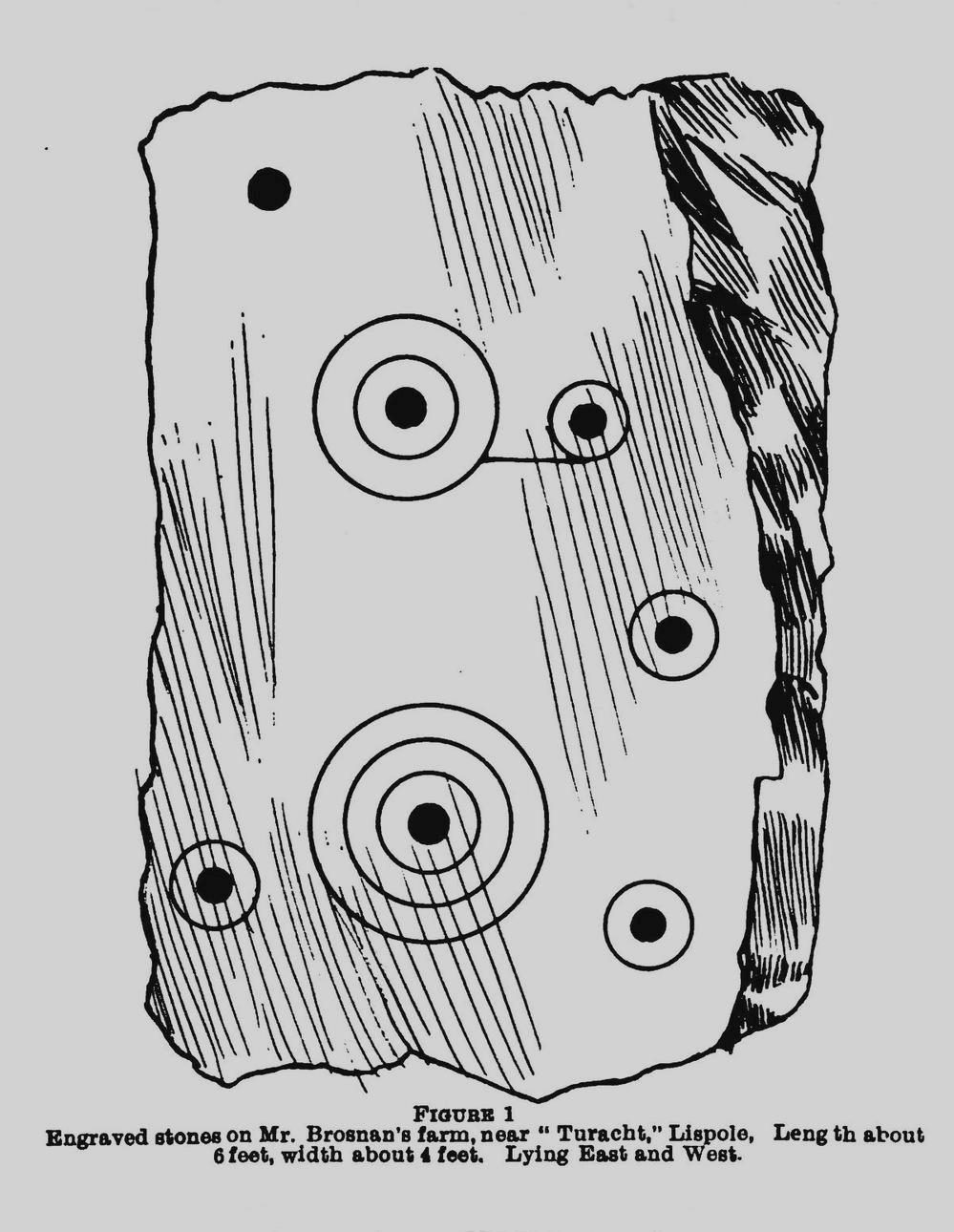
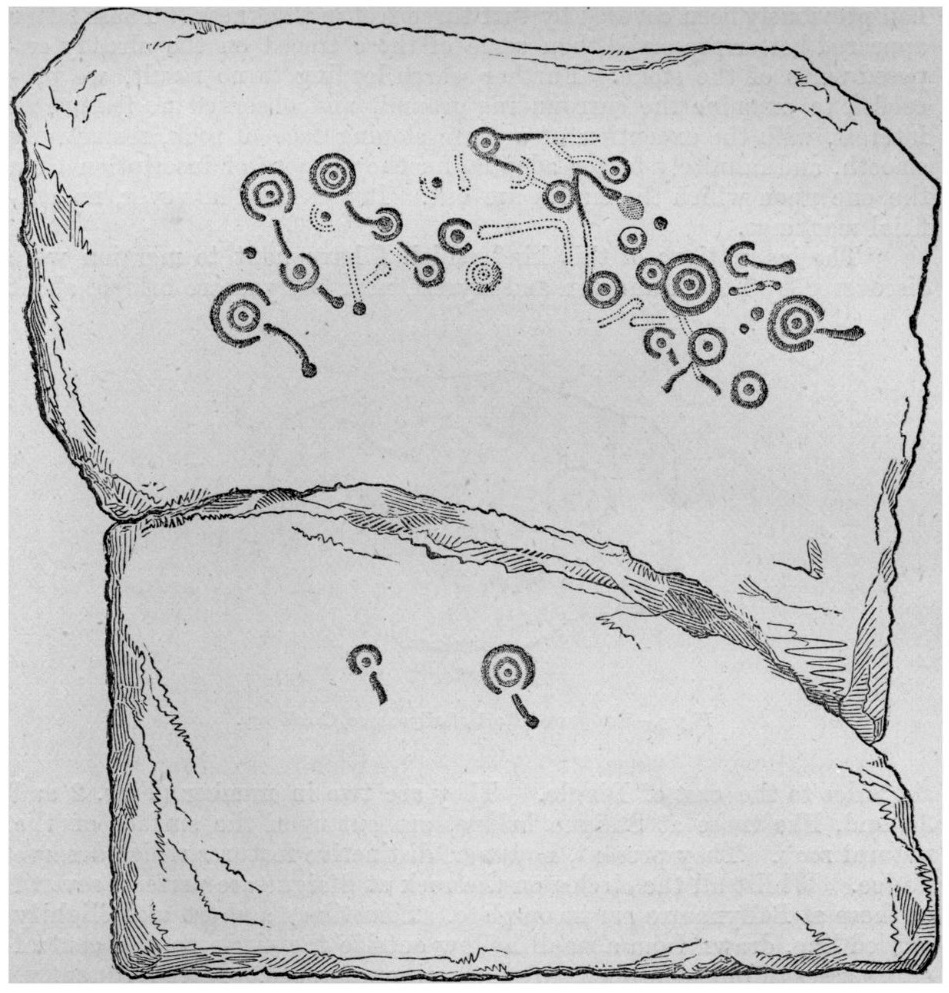
Cup-and-Ring Stone (lost): OS Grid Reference – Q 508 001
Archaeology & History
An impressive multiple cup-and-ring stone was discovered near the beginning of the 20th century by Rev. Orpen (1908) who gave a reasonably good description of its whereabouts and, thankfully, a sketch of the basic design. But since his day, it’s not been seen again. He told us that after,
“Leaving the Church of St. Martin, and passing down the main road towards Dingle, we take a turn to the left, and cross the river to the village of Furacht. Here, on the farm of Mr. Brosnan, about 300 yards up the hill towards the south, may be seen a carved stone…marked with cups and concentric circles. The stone is about 6 feet long by 4 feet wide. It was partially covered with sods of grass, which, when they were cleared away, revealed some other cups and circles. This stone lies on one of the ditches running north and south on Mr. Brosnan’s farm.”
The grid-reference given for this site is taken from Judith Cuppage’s (1986) fine survey, who had no success finding it. But a stone of this size shouldn’t be too difficult to locate—unless it’s either covered in vegetation or it’s been destroyed. Do any Lispole or Dingle folk know what’s become of it?
References:
Cuppage, Judith, Archaeological Survey of the Dingle Peninsula, Oidhreacht Chorca Dhuibhne: Ballyferriter 1986.
Orpen, R., “Antiquities near Lispole, Co. Kerry,” in Kerry Archaeological Magazine, volume 1, 1908.
Acknowledgements:Huge thanks for use of the Ordnance Survey map in this site profile, reproduced with the kind permission of the National Library of Scotland.
Cup-and-Ring Stone (lost): OS Grid Reference – Q 58 04
Archaeology & History
Judith Cuppage (1986) reported that in 1953 a Mr Adams of the County Kerry Field Club, when he was checking out two recognised petroglyphs in this locale (Coumduff [1] and [2]), his attention was brought to this, previously unrecognized carving,
“which lay against the bank from which it had previously fallen. It was decorated with numerous cup-marks, at least one of which were enclosed by circles.”
For some reason, Mr Adams didn’t give any good directions as to its whereabouts and as a result, since that day in ’53, it hasn’t been seen since! The likelihood is that it lays somewhere either in-between, or at least pretty close to the other two carvings. If there are any explorers in that neck o’ the woods who might know where it lies sleeping, please let us know so we can bring it back to life, so to speak.
References:
Cuppage, Judith, Archaeological Survey of the Dingle Peninsula, Oidhreacht Chorca Dhuibhne: Ballyferriter 1986.
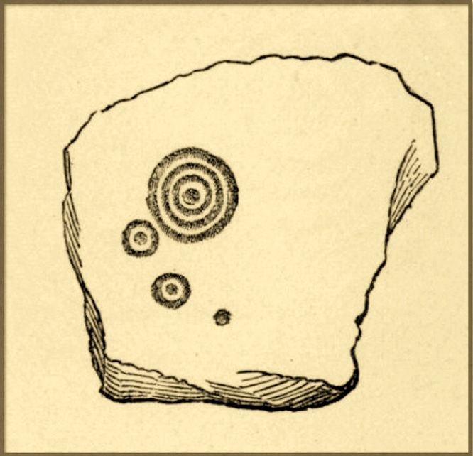
Cup-and-Ring Stone (lost): OS Grid Reference – Q 53 03?
Archaeology & History
Gowlane East (3) stone (Graves 1877)
First discovered by Richard Hitchcock in 1848, this petroglyph (along with the Gowlane East (2) carving) was one of two missing stones in the area that James Graves (1877) thought were seemingly “fragments of a large monument,” although he said nothing more about it and, sadly, Mr Hitchcock’s sketch here is all that we have left to guide us. The carving may have come from one of the nearby raths, souterrains, or have been part of a circle or cairn. The stone looks to have been reasonably small in size and, hopefully, is residing in a wall somewhere or is just buried in a field.
There are several Gowlane place-names in the area, but Judith Cuppage (1986) told that the great 19th century artist and antiquarian George du Noyer “identified the townland as Gowlane East”, although the closest “neighbouring townland” would be Gowlin (Gualainn). If any local folk know where this might be hiding, please let us know. (the grid reference cited here is a very vague guess!)
References:
Cuppage, Judith, Archaeological Survey of the Dingle Peninsula, Oidhreacht Chorca Dhuibhne: Ballyferriter 1986.
Graves, James, “On Cup and Circle Sculptures as Occurring in Ireland,” in Journal Royal Society Antiquaries, Ireland, volume 4 (4th series), April 1877.
Acknowledgements:Huge thanks for use of the Ordnance Survey map in this site profile, reproduced with the kind permission of the National Library of Scotland.
Cup-and-Ring Stone (lost): OS Grid Reference – Q 53 03?
Archaeology & History
Gowlane (2) carving (in Graves 1877)
When James Graves (1877) described the gorgeous Aghacarrible petroglyph, he told that “in the neighbouring townland of Gowlane” were three other carvings—with this fine multi-ringed design being one of them. It was first discovered and drawn by Richard Hitchcock in 1848 and was thought by Graves to have been broken from “a larger monument.” (like the Gowlane East [3] carving) Whether it was from a cairn, a souterrain or a stone circle, we can but guess. And we must also guess as to where it might be now, for no account of it has appeared since Mr Graves’ description. With any luck it will be in a wall somewhere, or simply buried in a field.
There are several Gowlane place-names in the area, but Judith Cuppage (1986) told that the great 19th century artist and antiquarian George du Noyer “identified the townland as Gowlane East”, although the closest “neighbouring townland” would be Gowlin (Gualainn). If any local folk know where this might be hiding, please let us know. (the grid reference cited here is a very vague guess!)
References:
Cuppage, Judith, Archaeological Survey of the Dingle Peninsula, Oidhreacht Chorca Dhuibhne: Ballyferriter 1986.
Graves, James, “On Cup and Circle Sculptures as Occurring in Ireland,” in Journal Royal Society Antiquaries, Ireland, volume 4 (4th series), April 1877.
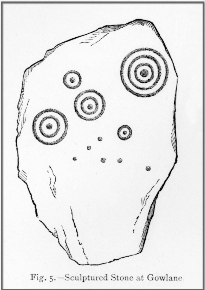
Cup-and-Ring Stone (lost): OS Grid Reference – Q 53 03?
Archaeology & History
Hitchcock’s 1848 sketch
This is one of three carvings illustrated in James Graves’ (1877) essay on Irish petroglyphs that were first discovered by a Mr Hitchcock in 1848, but which hasn’t been seen since. Graves described the impressive Aghacarrible carving and then told how, “in the neighbouring townland of Gowlane” this and other petroglyphs existed. A series of multiple cup-and-rings and some lines of cup-marks are clearly illustrated on Hitchcock’s fine sketch, but no detailed notes were ever made of the place. It’s presumed that this carving is on an earthfast rock, as the other two others were broken pieces from what he said was a “larger monument.”
There are several Gowlane place-names in the area, but Judith Cuppage (1986) told that the great 19th century artist and antiquarian George du Noyer “identified the townland as Gowlane East”, although the closest “neighbouring townland” would be Gowlin (Gualainn). If any local folk know where this might be hiding, please let us know.
References:
Cuppage, Judith, Archaeological Survey of the Dingle Peninsula, Oidhreacht Chorca Dhuibhne: Ballyferriter 1986.
Graves, James, “On Cup and Circle Sculptures as Occurring in Ireland,” in Journal Royal Society Antiquaries, Ireland, volume 4 (4th series), April 1877.
Cup-and-Ring Stone (lost): OS Grid Reference – Q 547 012
Archaeology & History
Graves’s 1877 sketch
This was one of two cup-and-ring stones discovered in the mid-1870s by Lord Dunraven and Rev. James Graves (1877) “near Ballynasare bridge,” both of which are now lost. It is much smaller than its compatriot, but sadly Mr Graves gave no notice as to its exact size nor its proximity to the other carving, although I presume they were pretty close to each other. He told that the carving was “cut upon the surface of the natural rock,” meaning that unless it’s been quarried or built over, it should still be there somewhere.
The grid reference cited here is an approximation given in Cuppage’s (1986) excellent survey, who told that its “precise location is not now known and may have been in any of the four townlands which converge at the bridge.” Hopefully it’ll be hiding away in some undergrowth, awaiting the attention of an antiquarian explorer. Are there any local folk who are able to help us out with this one?
References:
Cuppage, Judith, Archaeological Survey of the Dingle Peninsula, Oidhreacht Chorca Dhuibhne: Ballyferriter 1986.
Graves, James, “On Cup and Circle Sculptures as Occurring in Ireland,” in Journal Royal Society Antiquaries, Ireland, volume 4 (4th series), April 1877.
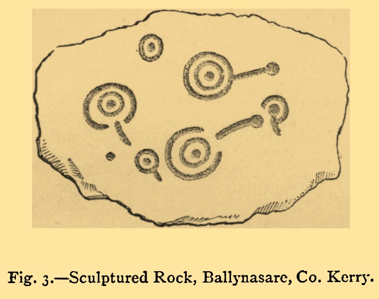
Cup-and-Ring Stone (lost): OS Grid Reference – Q 547 012
Archaeology & History
Ballynasare Bridge (1) (Graves 1877)
This is one of two impressive petroglyphs that were discovered by Lord Dunraven and Rev. James Graves in the mid-1870s, “near Ballynasare bridge”, but which are now lost (the other one is the Ballynasare Bridge (2) stone). This carving is the larger and more impressive of the two that they found, on which he described some of the carved rings as “incomplete.” Although Graves (1877) didn’t give a detailed description of the carving, this drawing (right) more than makes up for his lack of words. One of the features that he did tell us about was one of the primary motifs in this design which modern students like to call radial grooves. “Sometimes,” he wrote, “a short and slightly curved line, drawn from a hollow outside the circle to the central cup, passes through the open part of the circumference. More frequently, this line stops short just as it reaches the break in the circle.”
The grid reference here is an approximation given in Cuppage’s (1986) excellent survey, who told that its “precise location is not now known and may have been in any of the four townlands which converge at the bridge.” Hopefully it’ll be hiding away in some undergrowth, awaiting the attention of an antiquarian explorer. Are there any local folk who are able to help us out with this one?
References:
Cuppage, Judith, Archaeological Survey of the Dingle Peninsula, Oidhreacht Chorca Dhuibhne: Ballyferriter 1986.
Graves, James, “On Cup and Circle Sculptures as Occurring in Ireland,” in Journal Royal Society Antiquaries, Ireland, volume 4 (4th series), April 1877.
Cup-Marked Stone (lost): OS Grid Reference – Q 6014 0226
Archaeology & History
A cup-marked stone that was reported at this position in the 1940s by the Kerry Archaeological Survey (KAS) had disappeared by the time Judith Cuppage (1986) wrote her survey. She told that “there is no visible trace or local knowledge of the” carving. It may well have been destroyed. Seemingly KAS made no notes or sketches of the site. (WTF?!?!?)
References:
Cuppage, Judith, Archaeological Survey of the Dingle Peninsula, Oidhreacht Chorca Dhuibhne: Ballyferriter 1986.
Cup-and-Ring Stone (lost): OS Grid Reference – Q 46 00
Archaeology & History
This lost carving probably still exists, but in all likelihood is well overgrown by vegetation. It was in that state of affairs when Rev. Orpen (1908) wrote about it more than a hundred years ago in his essay on the petroglyphs between Lispole and Dingle. After describing and illustrating several carvings in the area, he told:
“I may mention here that further west, near Ballintaggart, at Ballywoonig, there is another single cup and circle which I found on a rock, the last of which was covered with clay and grass. I had these removed, hut nothing further was disclosed.”
Sadly, he left us with no sketch. His wording suggests that the carving is close to the southern boundary of Ballinvownig, pehaps near the souterrains near Ballintaggart house…? Perhaps some local antiquarian explorers might be able to find out where it’s hiding—although it will doubtless be covered in vegetation.
References:
Cuppage, Judith, Archaeological Survey of the Dingle Peninsula, Oidhreacht Chorca Dhuibhne: Ballyferriter 1986.
Orpen, R., “Antiquities near Lispole, Co. Kerry,” in Kerry Archaeological Magazine, volume 1, 1908.
Cup-and-Ring Stone (removed): OS Grid Reference – NT 12364 32627
Also Known as:
Drumelzier Carving
Archaeology & History
Position of stone in cairn
A carving that was located at the edge of a cairn on a knoll on the east-side of the River Tweed, this is an odd design that now lives in Edinburgh’s central museum: odd, inasmuch as the design looks as if it’s a typical cup-and-ring carving, yet none of the cups on this stone were ever hollowed or pecked out, and so the “cups”, so to speak, are actually small rings (if that makes sense!). There are a number of similar unhollowed “cups” on other carvings that are found associated with prehistoric tombs, so perhaps this aspect was something of a burial trend—amongst a very small tribal group, perhaps… It’s an element that was remarked upon in Simpson & Thawley’s (1972) examination of petroglyphs in neolithic tombs that were called “passage grave style” carvings: a sort of dyslexic cup-and-ring design no less! The intriguing thing about this carving is that it’s one in a small cluster of dyslexic cup-and-rings that are found in this part of Scotland—in an area where rock art itself is pretty scarce. Which begs the question: was it a local tribal style? Anyhow…
The carving was first uncovered when J.H. Craw (1930) excavated the aforementioned cairn, finding therein a number of cists. There’s speculation that the petroglyph might originally have been a covering stone for one of the cists, but we don’t know for sure. Craw described the carving as follows:
Craw’s 1930 sketchRon Morris’ 1981 sketch
“The ring-marked slab…measures 3 feet by 2 feet by 6 inches. It lay at the north side of the cairn (highlighted in sketch, PB), outside the encircling ring, but may originally have been the cover of cist No.2. On the upper side are five shallow ring-markings, four being double and one single. The former measure 3 inches to 4 inches in diameter, and the latter 1¾ inch. The figures are thus much smaller than in typical cup-and-ring-marked stones, and the lines are only ¼ inch in width. The only similar markings known to me are on a slab which I found a number of years ago near the site of several former cairns, and forts at Harelawside near Grant’s House, Berwickshire. The stone is now in our Museum.”
The “museum” in question being Edinburgh’s National Museum (I don’t know if it’s in a box somewhere or on public display, which is where it needs to be). If anyone can get a good photo of this carving, please send it to us or add it on on our Facebook group.
Morris, Ronald W.B., “The Cup-and-Ring and Similar Early Sculptures of Scotland; Part 2 – The Rest of Scotland except Kintyre,” in Transactions of the Ancient Monuments Society, volume 16, 1969.
Morris, Ronald W.B., The Prehistoric Rock Art of Southern Scotland, BAR: Oxford 1981.
Ritchie, Graham & Anna, Edinburgh and South-East Scotland, Heinnemann: London 1972.
Royal Commission on the Ancient & Historical Monuments, Scotland, Peeblesshire – volume 1, Aberdeen University Press 1967.
Simpson, D.D.A. & Thawley, J.E., “Single Grave Art in Britain,” in Scottish Archaeological Forum, no.4, 1972.
Acknowledgements:Huge thanks for use of the Ordnance Survey map in this site profile, reproduced with the kind permission of the National Library of Scotland.
“Leaving the Church of St. Martin, and passing down the main road towards Dingle, we take a turn to the left, and cross the river to the village of Furacht. Here, on the farm of Mr. Brosnan, about 300 yards up the hill towards the south, may be seen a carved stone…marked with cups and concentric circles. The stone is about 6 feet long by 4 feet wide. It was partially covered with sods of grass, which, when they were cleared away, revealed some other cups and circles. This stone lies on one of the ditches running north and south on Mr. Brosnan’s farm.”