Healing Well (lost): OS Grid Reference – SK 692 293
Archaeology & History
At the rear east-side of st. Luke’s church in what was once the old stable yard at the back of the rectory, a large pond can be seen. In the 19th Century it was much smaller than it’s present size—and in the centuries before that, it took the simple form of a clear spring of water, known by local folk simply as the Mineral Spring. The medicinal properties of the waters seem to have been forgotten…
References:
Wadkin, H.M., Hickling: Reflections of Yesteryear, Sherwood Free Press 1991.
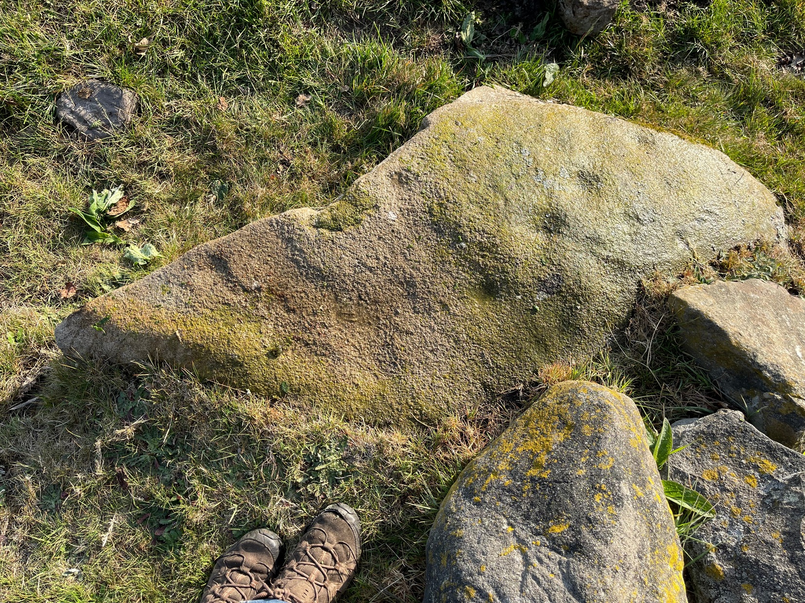
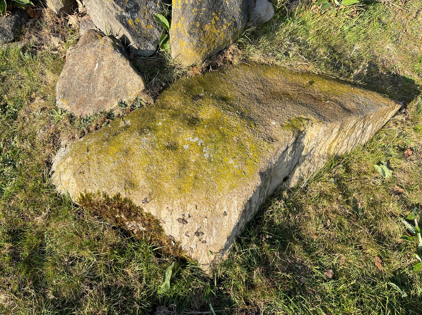
In Hawksworth village, less than 100 yards past the primary school, take the footpath on your left into the open fields. 200 yards down the fields, go over the stile on your right, into the next field and walk diagonally across it (SW) for 250 yards until you reach the wall; then walk alongside it, west, for another 150 yards where the walling goes due south and walk down here for 135 yards, going through the gate at the bottom into the next field and, at the bottom of this one go through the gate and bear right. OK, now walk along the wall-side for 55 yards and you’re just about standing on it! Alternatively you can reach it via the Hawksworth Spring (1) and (4) carvings, following the wall along for roughly 150 yards till you reach the gate. Go through here and walk diagonally NNW across the field for nearly 150 yards where you’ll see the stone stuck out in front of the wall.
Archaeology & History
My first sight of this came about as I walked alongside the walling. Approaching the stone, I noticed what looked like a recent cup-like marking with a curved line emerging from it on its eastern surface; but it didn’t look too old and was more like the scratch-marks you see sometimes when farmers have been dragging rocks along to be used in walling. So I shrugged in slight disappointment—until the far-side, the western-side of the stone came into view.
Line of cupsMain scatter of cups
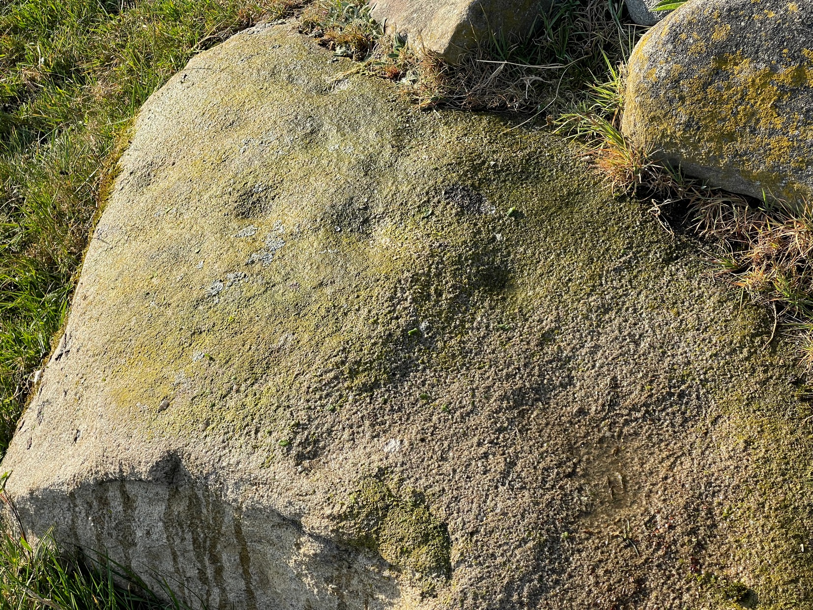
Sloping ever-so-slightly down into the ground, the surface of the stone had a cluster of quite worn, shallow, but distinct cup-markings between one and two inches across, four of which ran in a line from the top to the edge of the stone in a slight curve. As I walked round it, looking from different angles, it became obvious that two or three other cups existed—mainly from the top to the western side of the rock. One seemed to exist near the edge, whilst two other faint ones sat to the side of the line-of-four—almost creating a square formation. From some angles it looked as if there may be faint lines running between some of the cups but (as usual) the sunlight didn’t really help highlight them and they could just be faded erosion lines.
Looking down at the cupsWater & sunlight & cups
It was obvious that a section of the stone on its southern edge had been broken off in the not-too-distant past, raising the idea that the design may originally have been larger than its present form. This thought returned when I walked another 60 yards west along the wall and came across a broken section of stone that had been placed into it, pretty recently, and on its vertical face noticed a single cup-mark in a good state of preservation, indicating that it had either been cut recently or instead been dug out of the ground not too long ago and shown intself to the world after a sleep of several millenia. Look at it when you have a gander at the main carving here and make up your own mind….
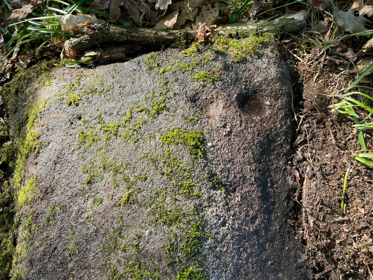
Take the same directions as if you’re going to visit the Hawksworth Spring (1) carving. From here, the small footpath at its side keeps going uphill, curving to the right and following the line of walling. After about 20 yards where the land begins to level out, keep your eyes peeled for a small elongated earthfast rock, less than three feet long, just to the left of the path and only three or four yards away from the wall. If the leaves have covered the stone, get on your hands and knees and scrub around a bit. You’ll find it!
Archaeology & History
Primary cup-marking
This was a frustrating find as there are several elements on the stone, only one of which I could be 100% certain about – and that’s the singular cup-marking on the top-left of the stone. Just next to this is what looks to be another one, unfinished, cut into a natural fissure in the rock—but the daylight was frustrating, allowing only glimpses of visual clarity on the stone. At the other end of the stone, as the photo shows, are what stand out as two or three more cup-marks, but these seem geophysical in nature—although examples such as these scatter the works of Boughey & Vickerman (2003; 2018) as authentic, which shows the problem we all have as rock art students. Anyhow, at least one of these cups is the real deal. I’ll let the computer-tech lads sort the rest of it out for us…
Once you’ve located the carvings of Hawksworth Spring (1) and (2), walk up the slope towards the topmost section of the walling where the land begins to level out. Hereby you’ll see the Hawksworth Spring (4) carving (if it’s not covered in leaves) several yards below the wall. Turn around and look diagonally to your left, into the trees, where you need to walk into and beneath the overhanging holly branches. Here you’ll reach the large earthfast rock whose edge rests up against the trunk of a larger tree. You can’t miss it!
Archaeology & History
Notable curious “cups”
I’m not 100% convinced that this a prehistoric design, despite it being listed as such in Boughey & Vickerman’s (2003) survey—although, to be fair, they do suggest it as being “doubtful.” The two most notable so-called “cups” have more of a recent hallmark to them and the other elements are troublesome to see with any certainty, but they may be geophysical in nature. Their description of it told us this was a “fairly large fine-grained rock with some included pebbles. Two pairs of cups, one pair connected by groove”. Make of it what you will….
References:
Boughey, Keith & Vickerman, E.A., Prehistoric Rock Art of the West Riding, WYAS: Wakefield 2003.
First mentioned in place-name records from 1409, this seemingly lost sacred well could be found in the south-side of St. Leodegarius’s churchyard. It was filled-in sometime in the 19th century when the ground around it collapsed to some considerable depth, so the hole was covered. Despite this, water kept re-appearing on and off over the decades and, in Bob Morrell’s (1988) holy wells survey, he told that following constant heavy rains in 1987, it was filled in for the last time.
References:
Bailey, Thomas, Annals of Nottinghamshire, Simpkin Marshall: London 1853.
Gover, J.E.B., Mawer, Allen & Stenton, F.M., The Place-Names of Nottinghamshire, Cambridge University Press 1940.
Harte, Jeremy, English Holy Wells – 3 volumes, Heart of Albion press: Wymeswold 2008.
Morrell, Robert, Nottinghamshire Holy Wells and Springs, Nottingham 1988.
Robin Hood wells are numerous in Yorkshire and Derbyshire, but finding them in this neck o’ the woods is unusual (a Robin Hood’s Farm can be found nearly 14 miles south). The waters here would have had obvious importance for local peasant folk in bygone centuries, perhaps with scatterings of Beltane and Midsummer rites hereby; but it seems that records are silent on such matters. The only reference I can find of this place is in Bracken’s (1860) fascinating work on Sutton Coldfield, where he told that,
“At the extremity of the parish, near Pype, a little field is still called the Bowbearer’s Croft. Tradition says two officers of the chase, bowbearers, had a lodge there; and that their duty was to guide the travellers across the wild country. A very old cottage, that had been well built, was removed from the croft in 1828. In that neighbourhood was a fountain, called Robin Hood’s well, now enclosed within the grounds of Penns, where the natural beauties of the situation have been judiciously displayed and improved by the taste of the late proprietor, Joseph Webster.”
Marshy ground to the east of Pype Hall fed the large pond, which is one contender for the site of this lost well. What has become of it? A search in the local library archives for any old manorial maps, or the field-name maps showing Bowbearer’s would prove truly helpful in relocating this site.
References:
Bracken, L., History of the Forest and Chase of Sutton Coldfield, Simpkin Marshall: London 1860.
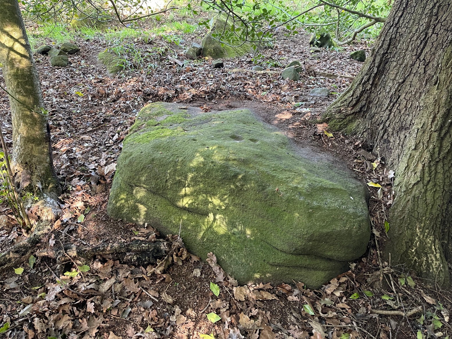
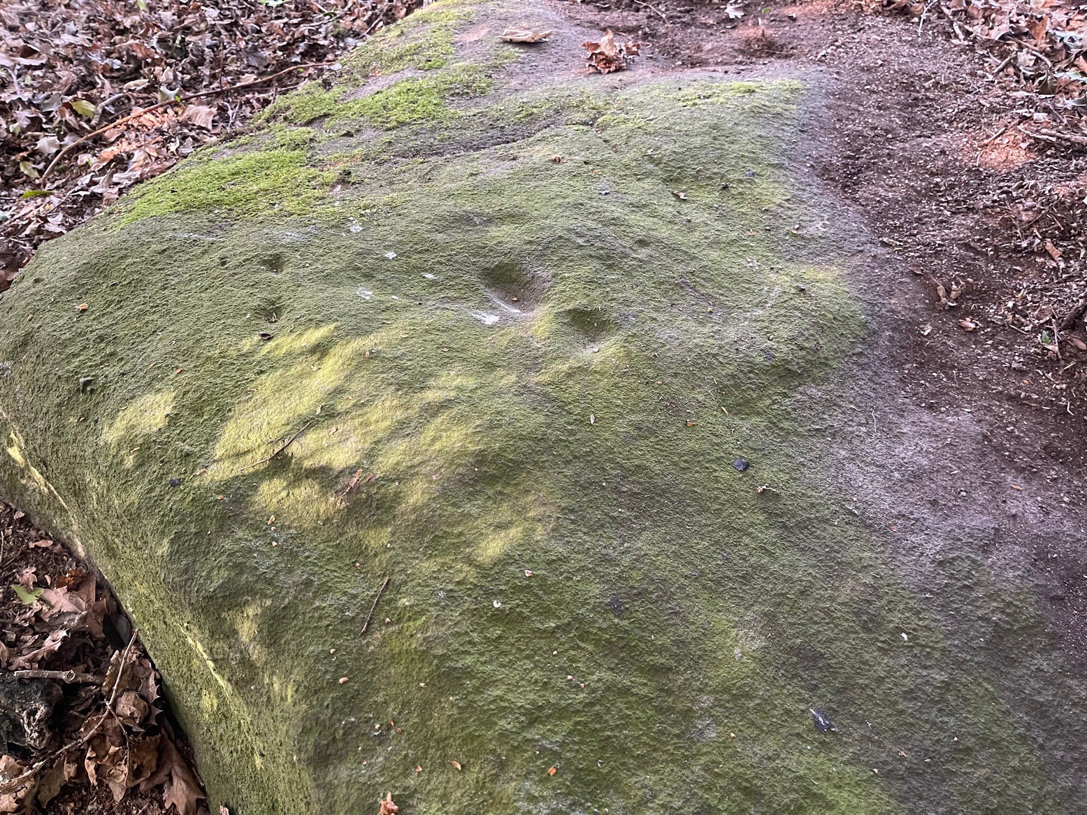
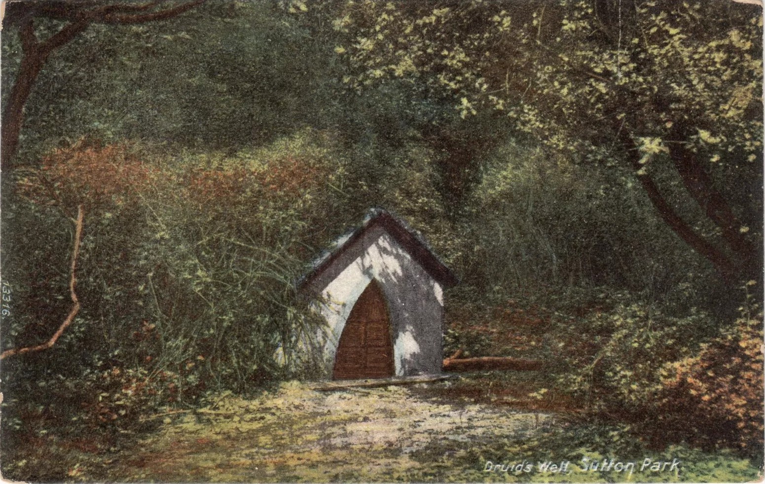
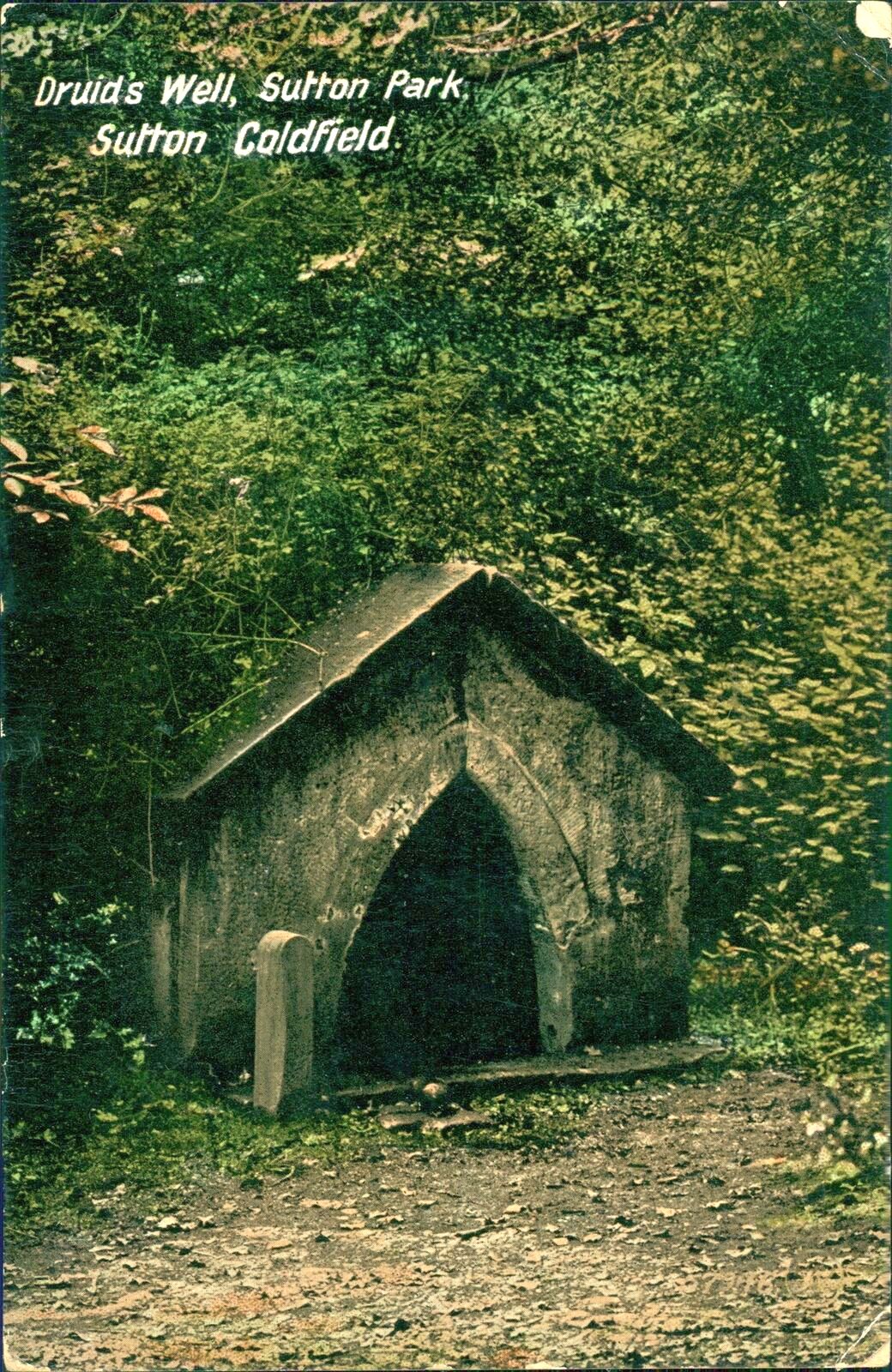
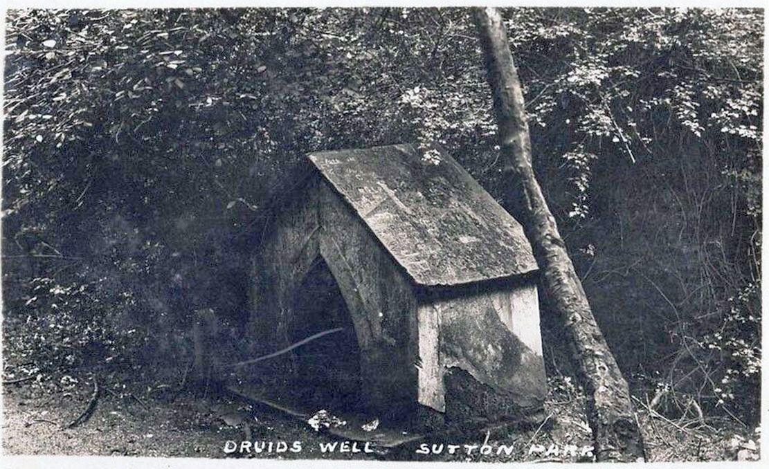
Highlighted on the 1884 Ordnance Survey map of the region and located beyond the far eastern end of Braceridge Lake, this legendary well has seen better days. A small well-house once covered the spring, but all we have left today is little more than a rectangular stone-lined concrete hole-in-the-ground where the waters collect (hopefully some local folk can bring it back to life). But in the 19th century it was well known, much frequented and maintained.
Not much seems to be known about its mythic history, as the traditions surrounding its dual pagan-christian dedication seem to have been forgotten. When the local writer Tom Burgess (1893) came to explore its history, he merely wrote:
“How it came to be called the Druids’ Well is not known, it is scarcely necessary to say that it can have no Druidical connection; it is very probable, however, that it was dedicated to Saint Mary long before the dam of Bracebridge Pool was made by Ralph Bracebridge in the reign of Henry V.”
Druids Well in 1917Druid’s Well in 1932
Jeremy Harte (2008) suggested that this well’s druidic association may have come from a local man, William Hutton who, in the middle of the 18th century, “speculated on a druid sanctuary near Sutton Coldfield.” But before Hutton, the 17th century Staffordshire topographer, Robert Plot, suggested that an arch-druid held residence on Barr Beacon, which is less than three miles west of here. This idea was echoed by Midgley (1904) who told that Barr Beacon “is supposed to have been a Druidical shrine.” Just over three miles to the northwest, the Druid’s Heath (a place-name derived, apparently, from an old family) at Aldridge also had its own array of folklore which, perhaps, may have had something to do with this well’s association. When Roy Palmer (1976) wrote about the Druid’s Well in his folklore survey, he told that Sutton Coldfield,
“is said once to have been the seat of the arch-druid of Britain; perhaps this was his well, which was later christianized.”
So much to choose from…
References:
Bord, Janet, Holy Wells in Britain – A Guide, HOAP: Wymeswold 2008.
Bracken, L., History of the Forest and Chase of Sutton Coldfield, Simpkin Marshall: London 1860.
Harte, Jeremy, English Holy Wells – volume 2, Heart of Albion press: Wymeswold 2008.
Midgley, W., A Short History of the Town and Chase of Suton Coldfield, Midland Counties Herald: Birmingham 1904.
Palmer, Roy, The Folklore of Warwickshire, Batsford: London 1976.
Acknowledgements:Huge thanks for use of the Ordnance Survey map in this site profile, reproduced with the kind permission of the National Library of Scotland.
Holy Well (destroyed): OS Grid Reference – SP 8234 9542
Also Known as:
Our Lady’s Well
Archaeology & History
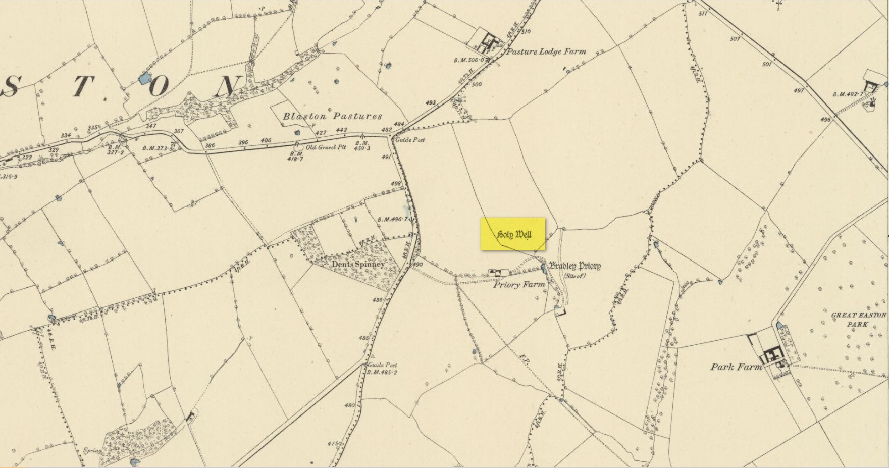
Site shown on 1885 map
There seems to be very little known about this site. It was located in fields just above the site of the Augustinian Priory of St Mary, founded in 1220 CE, where now is Priory Farm, but there seems to be no trace left of it. The great Leicestershire antiquarian John Nichols said the well had been dedicated to Our Lady, the Virgin Mary. This was echoed in John Curtis’ (1831) survey, who told that, “where the Priory formerly stood, a Dwelling House has been erected; and near it is a Well called Our Lady’s Well.” He told that it was deep and “walled below the surface.”
References:
Curtis, John, A Topographical History of the County of Leicester, W. Hextall: Ashby-de-la-Zouch 1831.
Rattue, James, ‘An Inventory of Ancient, Holy and Healing Wells in Leicestershire’, in Transactions Leicestershire Archaeological & Historical Society, volume 67, 1993.
Trubshaw, Bob, Leicestershire and Rutland’s Holy Wells, Heart of Albion: Nottingham 2024.
Acknowledgements:Huge thanks for use of the Ordnance Survey map in this site profile, reproduced with the kind permission of the National Library of Scotland.
Cup-and-Ring Stone (removed): OS Grid Reference – NT 12364 32627
Also Known as:
Drumelzier Carving
Archaeology & History
Position of stone in cairn
A carving that was located at the edge of a cairn on a knoll on the east-side of the River Tweed, this is an odd design that now lives in Edinburgh’s central museum: odd, inasmuch as the design looks as if it’s a typical cup-and-ring carving, yet none of the cups on this stone were ever hollowed or pecked out, and so the “cups”, so to speak, are actually small rings (if that makes sense!). There are a number of similar unhollowed “cups” on other carvings that are found associated with prehistoric tombs, so perhaps this aspect was something of a burial trend—amongst a very small tribal group, perhaps… It’s an element that was remarked upon in Simpson & Thawley’s (1972) examination of petroglyphs in neolithic tombs that were called “passage grave style” carvings: a sort of dyslexic cup-and-ring design no less! The intriguing thing about this carving is that it’s one in a small cluster of dyslexic cup-and-rings that are found in this part of Scotland—in an area where rock art itself is pretty scarce. Which begs the question: was it a local tribal style? Anyhow…
The carving was first uncovered when J.H. Craw (1930) excavated the aforementioned cairn, finding therein a number of cists. There’s speculation that the petroglyph might originally have been a covering stone for one of the cists, but we don’t know for sure. Craw described the carving as follows:
Craw’s 1930 sketchRon Morris’ 1981 sketch
“The ring-marked slab…measures 3 feet by 2 feet by 6 inches. It lay at the north side of the cairn (highlighted in sketch, PB), outside the encircling ring, but may originally have been the cover of cist No.2. On the upper side are five shallow ring-markings, four being double and one single. The former measure 3 inches to 4 inches in diameter, and the latter 1¾ inch. The figures are thus much smaller than in typical cup-and-ring-marked stones, and the lines are only ¼ inch in width. The only similar markings known to me are on a slab which I found a number of years ago near the site of several former cairns, and forts at Harelawside near Grant’s House, Berwickshire. The stone is now in our Museum.”
The “museum” in question being Edinburgh’s National Museum (I don’t know if it’s in a box somewhere or on public display, which is where it needs to be). If anyone can get a good photo of this carving, please send it to us or add it on on our Facebook group.
Morris, Ronald W.B., “The Cup-and-Ring and Similar Early Sculptures of Scotland; Part 2 – The Rest of Scotland except Kintyre,” in Transactions of the Ancient Monuments Society, volume 16, 1969.
Morris, Ronald W.B., The Prehistoric Rock Art of Southern Scotland, BAR: Oxford 1981.
Ritchie, Graham & Anna, Edinburgh and South-East Scotland, Heinnemann: London 1972.
Royal Commission on the Ancient & Historical Monuments, Scotland, Peeblesshire – volume 1, Aberdeen University Press 1967.
Simpson, D.D.A. & Thawley, J.E., “Single Grave Art in Britain,” in Scottish Archaeological Forum, no.4, 1972.
Acknowledgements:Huge thanks for use of the Ordnance Survey map in this site profile, reproduced with the kind permission of the National Library of Scotland.
A little-known multiple ringed carving was discovered a few years ago during the excavation of a prehistoric cairn just immediately east of the A701 roadside, several miles south of Broughton. The cairn itself had been recognised many years prior to the recent excavation, when one of two cists inside it was noted by R.B.K. Stevenson (1940), and which was subsequently described in slightly more detail in the Royal Commission Inventory (1967). But when the modern investigation was undertaken by the Biggar Archaeology Group in 2008, a damaged but impressive carving was uncovered that somehow hadn’t been noticed before. It was described in Tam Ward’s (2008) excavation report where he told that,
Carving in situ (photo courtesy Jim Ness)Carving looking N: courtesy Jim Ness
“lying almost immediately on the east side of Cist 1 is an angular rock…measuring 1m long and over 0.3m wide on the uppermost face, itself lying at an angle facing SW and away from the cist. The rock has fractured due to weathering in post deposition times, as indeed several other surface stones had, but on the widest part of the upper surface are at least seven concentric lines faintly pecked into the smooth flat surface of the stone. The lines are up to 10mm wide and appear to have been intended to form semi ovals on the edge of the rock. The outer ring forms an arc of c270mm on the long axis by c140mm on the short one (the former measurement being straight between the ends of the lines and the latter being a radius across the design). The terminals of the inner curved line are about 80mm apart. The lines are slightly irregular in distance from one another. Although it is far from certain, it does not appear that the rock has been part of a larger one with a more complete design on it, rather the pecking appears not to have been finished since the surface of the rock is similar in appearance overall while the abrasion of the carving varies.”
Fractured design (photo courtesy Jim Ness)
The carving remains in place with the cist, which was covered back over when the excavation had been finished.
Carvings such as this are uncommon in this neck o’ the woods; although less than a mile downstream from here, on the other side of the river, another petroglyph—known as the Drumelzier carving—accompanied another prehistoric tomb. Apart from this, there’s a great scarcity of carvings scattering the Lowlands—although it’s likely that there are others hiding away, waiting to be found on these hills…
References:
Royal Commission on the Ancient & Historical Monuments, Scotland, Peeblesshire – volume 1, Aberdeen University Press 1967.
Stevenson, R.B.K., “Cists near Tweedsmuir,” in Proceedings Society Antiquaries, Scotland, volume 74, 1940.