Crosses / Legendary Rocks (destroyed): OS Grid Reference – SE 1975 2909
Archaeology & History
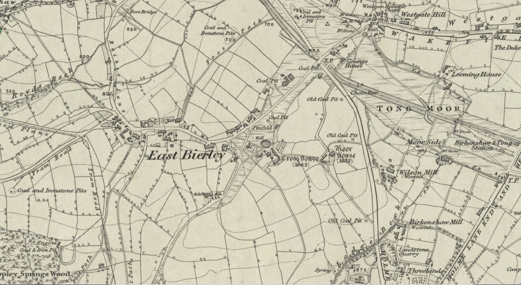
Site location at Cross House
Not to be confused with a much more renowned namesake above Ilkley, this was the name given to two old stones that once existed in the middle of the East Bierley hamlet (as it was then) southeast of Bradford. They were two large boulders next to each other, not far from the early farmstead of Cross House (see map, right) and were described in James Parker’s (1904) historic collage of the area, where he informed us that:
“On the village green (are) the primitive large stones locally called the “Cow and Calf stones,” which used to be in days gone by a Preaching Cross and Market Cross.”
When William Cudworth (1876) described the place nearly thirty years prior, he only mentioned a single cross, telling us:
“There is a lane which has long been called Kirkgate at Birkenshaw, leading up to an ancient cross on the hill. The fact of this cross being on the hill must have given rise to the name Kirk (church) gate, as there was not, until a few years ago, any church at Birkenshaw. In a previous paper we had occasion to notice the existence of the cross as an evidence of a pre-church period.”
The meaning behind the name Cow & Calf is unexplained by our respective authors, although Cudworth’s citation of “the cross as an evidence of a pre-church period” is probably not without merit here. It seems very likely that the animal names of the two large stones—akin to the Cow & Calf Rocks at Ilkley and others of the same name elsewhere in the country—that sat near the top of the hill, probably possessed a creation myth similar to others of the same name. From this, it seems logical that local folk held the rocks as important, which would have obviously attracted the regressive attention of Church—so they stuck a cross here to christianize the place and in doing so ensured that local people could continue using the place as a meeting place. This practice (as if you didn’t already know) was widespread.
Although Mr Cudworth seems to give the first real account of the place, field-name records of 1567 listed a ‘Cowrosse’, which may have been the “cross on the Cow” stone. A.H. Smith (1961) listed the site and suggested the element –rosse may derive from a local dialect word meaning a marsh, but a ‘cow’s marsh‘ seems a little odd. It is perhaps just as likely that an error was made in the writing of rosse instead of crosse.
References:
Cudworth, William, Round about Bradford, Thomas Brear: Bradford 1876.
Parker, James, Illustrated History from Hipperholme to Tong, Percy Lund: Bradford 1904.
Smith, A.H., The Place-Names of the West Riding of Yorkshire – volume 3, Cambridge University Press 1961.
Mentioned only in passing in the Becca and Aberford Enclosure Act of 1825, all remains of this site have gone. It was subsequently referred to by Edmund Bogg (1904) in his journey through Elmet as previously standing where the Roman road veered off to the northeast from the “new road”, as it was then. Bogg’s brief description told that from Nut Hill,
“A little distance south, where the old and new roads part, formerly stood a cross; Highcross Cottage keeps its memory green.”
References:
Bogg, Edmund, The Old Kingdom of Elmet, James Miles: Leeds 1904.
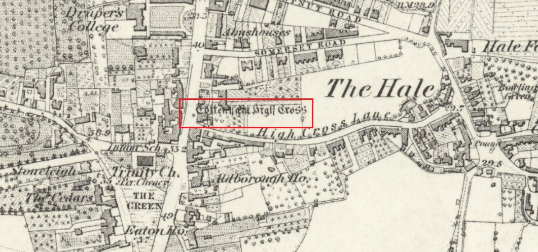
The Cross is on the east side of the A10 Tottenham High Road, on the traffic island at the Monument Way Junction.
Archaeology & History
Cross shown on 1873 map
One of the earliest records of what was called the “hie crosse” is contained in a court-roll of 1456. It was at that time a wooden wayside cross, but there are hints that its origins may go back to Roman times. The Cross is next to what was the southern end of Ermine Street, built by the Romans where there was no pre-existing roadway and described as the most important thoroughfare in Britain: built to give direct communication to the main centres of the military occupation at Lincoln and York. Writing of Roman land survey marks, the now discredited early 20th century Middlesex historian Sir Montagu Sharpe (1932) thought Tottenham Cross possibly marked an earlier (i.e. Roman) stone, although no archaeological evidence has been found to support this. As it was next to Ermine Street it could equally have been a milestone or ceremonial pillar. After the Romans left it may have become a local heathen shrine which, with the coming of Christianity, was ultimately replaced by a wooden cross—but this is speculation, and we will probably never know why and when the original cross was placed where it was.
Originally in the historic County of Middlesex, the settlement of Tottenham surrounding the Cross was known from mediaeval times to the 19th century as ‘Tottenham High Cross’. Local historian William Robinson writing prior to 1840 thus describes the Cross:
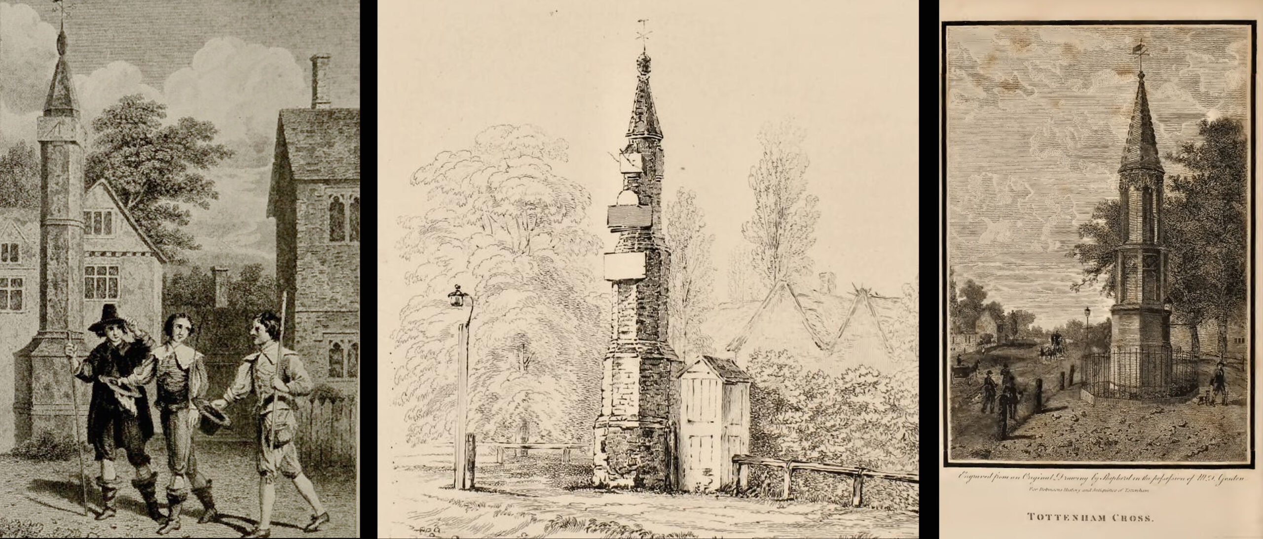
“About the year 1580, a column of wood was standing, with a square sheet of lead on the top to throw off the water, supported by four spurs: these, being decayed and rotten, were taken down, about the year 1600, by Dean Wood, Dean of Armagh, who at that time resided in a house on the east side of it, and who erected on its site an octangular brick column, pointed at the top and crowned with a weathercock, and the initials of the four cardinal points, and under the neckings, small crosses, which were called tau-crosses, according to the true cross or Greek letter T.
“Tottenham High Cross, as it appeared in 1788, was an octangular brick pillar, divided into four stories, viz.: a double plinth, first portion of the pillar; second portion, of the same; and a pinnacle; each plinth and story rendered distinct one from the other by certain appropriate mouldings ; and the whole design appeared without any kind of ornament, pointed at the top and crowned with a weathercock. The Cross having fallen into decay, several of the inhabitants of the parish entered into a subscription, in the year 1809, for the purpose of putting it into a proper state of repair, and about the sum of £300. was raised. It was accordingly repaired, and covered with Parker’s cement. The octangular plan, and the proportions of the Cross in its four stories, have not been departed from ; but in other respects it is a new work ; some of the decorations seem to be formed from the exterior and interior of the chapel of Henry VIII; the double plinths or pedestals are as plain as before, but the intermediate mouldings are new; the first portion of the pillar consists of angular pilasters at each cant done with a pointed head; compartment of five turns, connecting itself with another compartment; above it diamonded, with a shield containing an imitation of the black letter. As there are eight faces to the upright, of course there are as many shields, each bearing a letter of the same cutting, beginning at the west face, TOTENHAM: in consequence of there being but eight shields, one of the T’s in the spelling has been necessarily dispensed with. The mouldings between this story and the second are worked into an entablature, with modern fancy heads and small pieces of ornaments alternately set at each angle.
“Second story—small buttresses at the angles of the octagon, with breaks and pinnacles, but no bases. The face of each cant has a compartment embellished with an ogee head, backed with narrow pointed compartments. The mouldings between this story and the pinnacle, making out a fourth story, give, at each angle, crockets, and its termination is with a double finial, but not set out in geometrical rule to the crockets below : there is at the top a vane, with N. E. W. S. The base is surrounded with a neat iron railing on Portland stone curb. The date at which these alterations were made is not placed in any conspicuous part of the structure.”
(left) engraving based on Samuel Wale’s 1759 illustration to Compleat Angler; (centre & right) 19th C views pre- and post-renovation
The craftsman who carried out the modernisation was a Mr. Bernasconia, working to the designs of a Mr. Shaw. Not everyone was pleased by the transformation. A regular contributor identified only as ‘An Architect’ made these caustic comments in the November 1809 edition of the Gentleman’s Magazine:
“Tottenham High Cross has this summer been covered over with Compo: it previously bore a simple appearance, but is now rendered of a very rich and elaborate cast, doing away in the first instance the Architectural history of the erection; and allowing it possible that there might once have been on the spot an Eleanora Cross, holding in contempt, by a want of due imitation, the characteristic style of decoration prevailed at at the time of the Queen’s demise. But according to the system of our Professional innovators, to destroy a sacred relick of antiquity, and to restore it as it is called, upon a model quite in a different style and nature, is one and the same thing. “Any thing is Gothick.”
“….Surveyed November 1809. Entirely covered with the proclaimed everlasting stuff, Compo; a stuff now the rage for trowelling over our new buildings, either on the whole surface, or in partial daubings and patchings; it is used in common with stone work, for instance, on an arcade, half one material, half the other; “ making good,” as it is called (abominable expedient) the mutilated parts of Antient Structures, there sticking on until it reverts (after exposure to the air for three or four years, more or less) to its first quality, dirt and rubbish, and then is seen no more….
“Provided this Compo effort had been advanced on any other occasion, and on any other piece of ground, where no piece of Antiquity was to become the spoil, such as an object to mark the centrical point of three or four counties, a general standard of miles or any other common document for the information or amusement of travellers, all would have been well, and some praise might have been bestowed, for its tolerable adherence to the above style, if not for the material wherewith it is made up. But as nothing of this sort will come in aid of the innovators, and only the barefaced presumption, “ alter or destroy, what was,” is to be encountered, let the detail of parts, put this matter to issue….”
Folklore
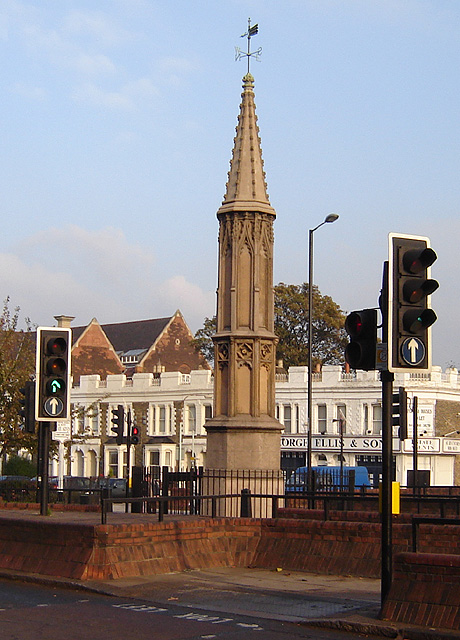
A modern view (Wikipedia Creative Commons)
The Cross stood in front of the Swan Inn, a place frequented by fishing writer Izaak Walton in the 1640s when he would go to fish in the nearby River Lea. In 1653 he published The Compleat Angler describing his fishing activities in the classical form of a philosophical dialogue between him as ‘Piscator’ and ‘Venator’ (hunter) and other passing characters, starting and ending his adventures at the High Cross. The 1759 edition of Compleat Angler contains the earliest illustrations of the Cross, with some slight artistic licence, by Samuel Wale.
Afterword
As the Cross now stands in the maelstrom of North London’s traffic, it is worth recalling American traveller Nathaniel Carter’s 1825 observation when travelling north from London:
“Passing Tottenham Cross, we entered a rich agricultural country, possessing the usual charms of English landscape.”
References:
An Architect (pseud.) – Architectural Innovation No. CXXXIX – The Gentleman’s Magazine, November 1809
Anonymous – Tottenham High Cross, The Gentleman’s Magazine, April 1820
Blair, John, The Church in Anglo Saxon Society, Oxford University Press 2005
Carter, Nathaniel Hazeltine, Letters From Europe..in 1825 ’26 & ’27, G & C & H Carvill, New York, 1829
Margary, Ivan D., Roman Roads in Britain, 3rd Ed., John Baker: London 1973.
Robinson, William, The History & Antiquities of the Parish of Tottenham, 2nd Ed., Nicholls & Son, W. Pickering, W.B. Hunnings: London 1840.
Sharpe, Montagu, Middlesex in British, Roman & Saxon Times, 2nd Ed., Methuen: London 1932.
Walton, Izaak, The Compleat Angler, Facsimile of the 1st Ed., containing illustrations from the 2nd US edition by John Major, No imprimatur, 1907.
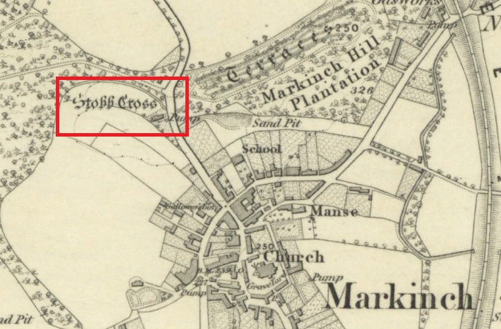
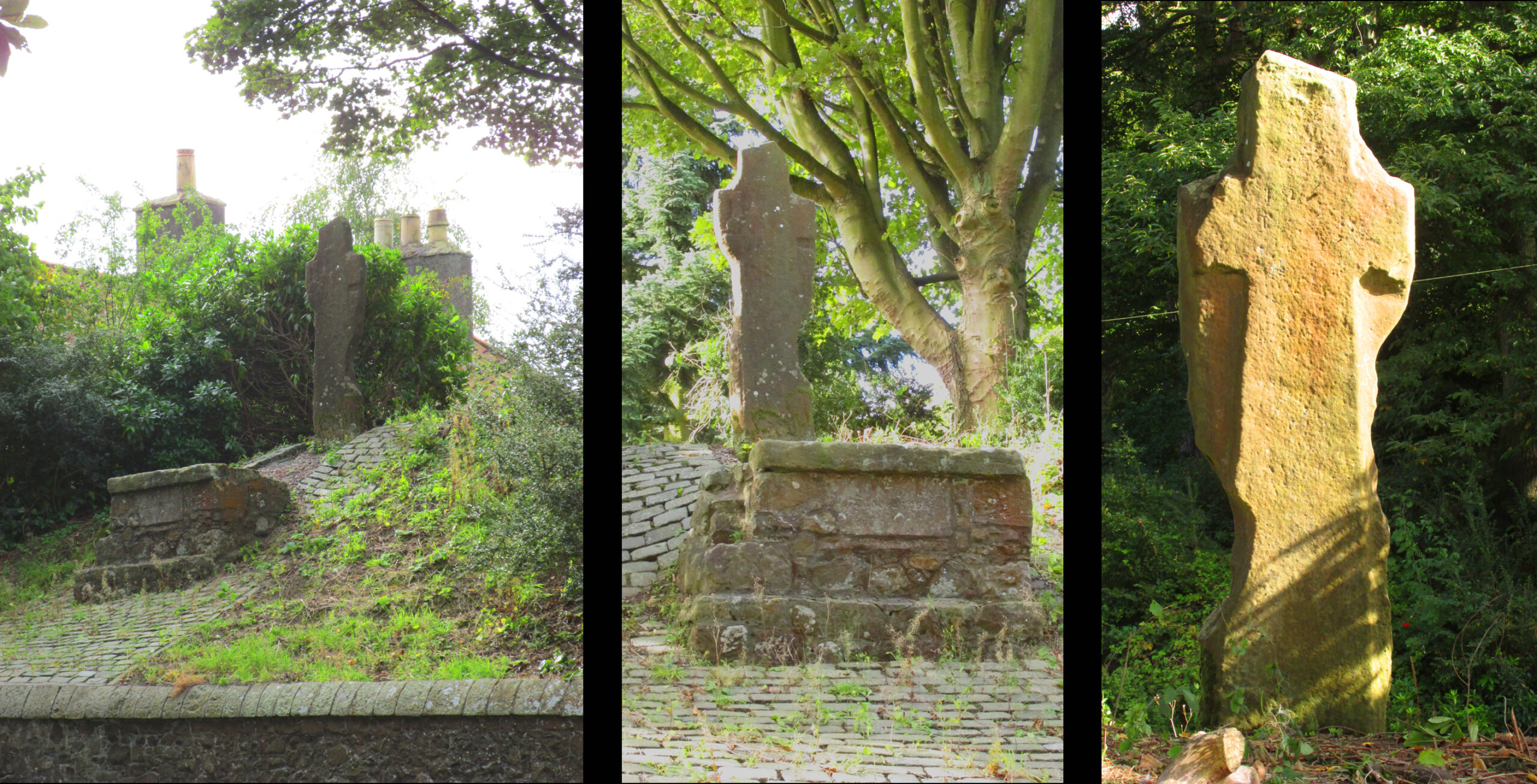
The cross is located on a bluff of land overlooking the west side of Stob Cross Road on the northern edge of Markinch.
Archaeology & History
In 1933, following a visit in 1925, the county archaeological inventory described it thus:-
Close beside the East Lodge of Balbirnie House, on a knoll 200 feet above sea-level, stands a stone known, from the nature of its sculpturings, as the “Stob Cross.” It is a somewhat mutilated rectangular slab, 7 feet 5 ½ inches in height, 2 feet broad at the base and 6 inches thick, having a plain cross carved in relief on the east and on the west face. The cross on the east is now very much damaged but sufficient remains to indicate that the arms have been 1 foot wide and that the shaft has measured 1 foot 5 inches across at the intersection. On the west face the design stands out in relief from 1 to 1 ¼ inches. The arms of the cross measure 11 ½ inches in width, and the upper limb, which tapers slightly to its extremity, is 12 ½ inches across at the point of intersection. The shaft measures 1 foot 2 inches across below the arms and widens gradually downwards to 1 foot 8 inches at the base. In 1790, when the cross was in danger of falling, the Earl of Leven had the position faced up with masonry, and the monument now stands, with its major axis north and south, on a two-stepped base of modern construction.
Roadside views l. & centre – Rear view r.
It’s certainly had a hard life, and its official designation as ‘early medieval’ leads us to suspect that it may have been a decorated Pictish cross that has had its ornamentation obliterated by Reformation iconoclasts. Those same iconoclasts may have concocted the ‘history’ recounted by Rev John Thomson (1794) in the Old Statistical Account of 1794 of what he describes as a ‘very coarse piece of work’:-
‘Vulgar tradition says, that it was erected to the memory of a gentleman, who fell on this spot, in a mortal encounter with one of his neighbours.’
Writing of Markinch, nineteenth century historian Aeneas Mackay (1896) has this to say:-
‘A cell of the Culdees was established there by one of the last Celtic bishops, and the ancient cross near Balgonie [sic] may mark its site.’
Modern place-name research ascribes Markinch as a place where horses were grazed while their owners were attending the early mediaeval courts and assemblies at Dalginch a quarter of a mile to the east, so the cross may at that time have been a waymarker. A roadside plaque describes the Cross as possibly marking the limit of an ancient sanctuary enclosure related to the church of St Drostan (known locally as St. Modrustus) in the centre of Markinch. Additionally, it was on the ancient (and recently revived) Fife Pilgrim Way from Culross to St Andrews, so would have been a wayside station for the pilgrims. which if it was a Pictish cross would have made it a target for desecration by iconoclasts. We are lucky that it has survived at all, and with the revival of the Pilgrim Way as a long distance path it will attract many new admirers.
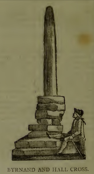
This long lost Cross could once be seen close to the Tudor era Byrnand Hall, which stood on the north side of the High Street. The Hall was demolished around 1780, and replaced by the present building, which is now a political club. The Cross was taken down around the same time, so we’re very fortunate to have a contemporary sketch.
Harry Speight (1906), the Great Yorkshire antiquarian, described the Cross when he was writing of the ‘big houses’ of Knaresborough, saying:
“Another notable old mansion was Byrnand Hall, which stood at the top of the High Street facing Gracious Street, and was rebuilt about a century ago. It was the property and seat for many generations of one of the leading families of Knaresborough, named Byrnand, one of its members being recorder of York in 1573. Opposite the house stood a very ancient stone cross, consisting of a plain upright column, without date or inscription, supported by several rudely-formed stones placed on three tiers or steps. It appears that one Richard Byrnand paid a fine and was permitted to enclose a cross standing on a piece of waste land then lately belonging to Robert Nessfield. The cross may be conjectured to have been either a memorial or boundary-stone. In those days ” it was not enough,” says the old antiquary, Hearne, ” to have the figure of the cross both on and in churches, chapels, and oratories, but it was put also in church-yards, and in every house, nay, many towns and villages were built in shape of it, and it was very common to fix it in the very streets and highways.
“This ancient relic, the site of which is now marked by a brass cross sunk in the causeway, was in after times called the Byrnand Hall Cross, from its proximity to the house of the same name. It stands on the road equidistant between York and Leeds, being eighteen miles from either place.”
At the end of the eighteenth century, E. Hargrove wrote:
“The (Byrnand) family mansion was situated at the end of the High-street, leading towards York. Near it formerly stood an ancient Cross, which being placed on the outside of the Rampart, and opposite to the entrance into the borough, seems to have been similar in situation, and probably may have been used for the same purpose, as that mentioned by Mr. Pennant, in his History of London, which stood without the city, opposite to Chester Inn; and here, according to the simplicity of the age, in the year 1294, and at other times, the magistrates sat to administer justice. Byrnand-Hall hath been lately rebuilt, by Mr. William Manby, who took down the remains of the old Cross, and left a cruciform stone in the pavement, which will mark the place to future times.”
Abbot J.I. Cummins, writing in the 1920s about the Catholic history of Knaresborough, told:
“Of the Byrnand Cross beyond the old town ditch the site is now marked in York Place by a brass cross let into the pavement for Christians to trample on.”
The Cross occupied an important position in the Knaresborough of old, at one of the highest points of the town by the junction of the modern High Street and Gracious Street, this latter being the road down the hill to the riverside and the troglodytic shrines of St Robert of Knaresborough and Our Lady.
Assuming the eighteenth century drawing is an accurate representation of the Cross, it does give the impression of considerable antiquity, and looks to have been 15-16 feet (4.75m.) high. From its appearance it looks like either a prehistoric monolith or an Anglo-Saxon ‘stapol‘ or column, and if it was the latter, it may have been erected to replace an earlier heathen wooden column or sacred tree following the replacement of the old beliefs by Christianity. If so, there may be no reason to deny Hargrove’s speculation that Byrnand Hall Cross once had a similar juridical function to the Chester Inn Cross in London.
References:
Bintley, Michael D.J., Trees in the Religions of Early Medieval England, Woodbridge, Suffolk, Boydell Press 2015.
Cummins, J.I., “Knaresborough,” in The Ampleforth Journal, Vol XXIV, No II, Spring 1929.
Hargrove, E., The History of the Castle, Town and Forest of Knaresborough, 5th Edition, Knaresborough 1790.
Speight, H., Nidderdale, from Nun Monkton to Whernside, London, Elliot Stock, 1906.
Cross (destroyed): OS Grid reference – TA 0424 2064
Archaeology & History
This long lost wayside cross was described in various local records from 1621 upwards. In the definitive place-name survey of this area, Kenneth Cameron (1991) told us that this was,
“A medieval cross dedicated to St James, situated at the point where the Thornton and Burnham roads meet… Mr R. Newton comments, “said to have replaced a wayside shrine. The foundations of the shrine were exposed when the Home Guard dug a defensive trench there at the beginning of the last war. Foundations destroyed by a bomb.””
References:
Cameron, Kenneth, The Place-Names of Lincolnshire – volume 2, EPNS: Nottingham 1991.
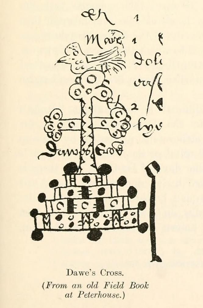
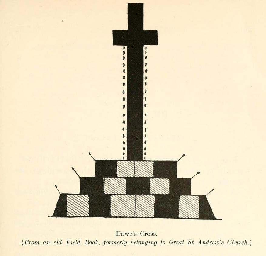
This is one of several medieval stone crosses in Cambridge that were destroyed several centuries ago. This particular one was erected on a three-stepped stone base at the old crossroads where, today, the modern A1307 of Regent Street meets the A603 Lensfield Road. It was described in an old Field Book of 1575 as standing being beside an old poplar tree, long gone. Mr H.P. Stokes (1915) gave us a short account of the site, telling:
“In describing the lane called “Deepway” between the London Road and the Hadstock Way and known as “King’s Lane” from the latter road to Hinton Way, mention was made of a Cross (called Dawe’s Cross) which stood at what is now known as Hyde Park Corner. Dawe’s Cross is often mentioned in ancient deeds, and in an old Field Book, which formerly belonged to the vestry of the Church of St Andrew the Great, there was a most interesting representation of it. This is here reproduced…from a copy in the celebrated Bowtell MSS.”
The cross stood along one of Alfred Watkins’ (1932) “archaic tracks”, or leys, in this area—although he wasn’t aware of its existence.
Cup-and-Ring Stone: OS Grid Reference – NS 8551 8819
Archaeology & History
Looking down on C-7c
Near the northwestern end of the small geological ridge that runs to the west of Castleton farmhouse, close to an awesome nine-ringed carving, we find this more simplified triple-ringed petroglyph. And although the carving is easy enough to describe, its labelling (as ‘Castleton 7c’) is rather troublesome. As with other carvings in this locale, the name of the stone is based on a survey done by Maarten van Hoek in the mid-1990s. But van Hoek’s sketch of Castleton 7c and the one shown in our photos, whilst very similar, possess attributes that aren’t on van Hoek’s drawing. Now this isn’t too odd, as many petroglyphs look different when lighting conditions change; to the point where some features you can see one day are almost invisible the next. But this carving has attributes that are very difficult to miss – and van Hoek’s detailing tended to be good. But, all this aside: until we can verify with certainty one way or the other and despite my suspicions that this isn’t what van Hoek described, I’m still entering this carving as Castleton 7c. So – now that bit’s out of the way…!
When we visited the site two years ago the day was dark and overcast, so we didn’t really have good conditions for seeing any faint carvings. But this wasn’t faint, thankfully. It was completely buried beneath soil and gorse bushes, but thankfully Paul Hornby managed to unearth the one you can see in the photos. If it is the Castleton 7c petroglyph, it was rediscovered by van Hoek on one of his ventures here in 1985.
Carving showing wavy lines on right…and from another angle
When we visited the site we only managed to uncover a small section of the stone, as the roots of the surrounding gorse prevented us from seeing more. (it’s tough stuff unless you’ve got the right gardening equipment!) The section we uncovered consisted of a cup-and-triple-ring. This is consistent with van Hoek’s sketch and description; but we also found there were two very notable ‘arcs’ on the outer edge of the rings—nearly opposite each other—as if another, fourth ring had been started. You can’t really miss these elements – and even in the poor lighting conditions we had, these outer arcs are very evident on a number of photos – especially when they are expanded to full-scale. However, as I mentioned, we were unable to uncover all the rock; but when van Hoek was here there was far less herbage. What he saw on this carving was as follows:
“Deturfing part of this ridge revealed a fine cup with three rings with a broadly pecked tail; one solo cup; one large oval ring with small central cup; and a faint cup with two rings, the outer one incomplete. The rock slopes 12º ENE.”
Crap drawing done in crap lightingvan Hoek’s 1996 sketch
The “broadly pecked tail” he mentions is also not really clear in any of the 60 photos we took. There is a faint line that runs through the three rings, into the central cup and out the other side: a single curving line no less. It’s certainly visible, but it’s far from broad. But there are a number of other lines coming out of the rings. These maybe just natural scratch marks, or even scratches acquired from farming activity. It’s difficult to say. In the poor light that we had, there as looked to be a single cupmark a few inches away from the rings, but this isn’t consistent with the position of the cupmark on van Hoek’s sketch.
There’s a simple solution to all this: we need to revisit the site and expose more of the rock. At least that will tell us once and for all whether this is the same as van Hoek’s stone, or whether we’ve found yet another new carving. Watch this space, as they say! 😉
References:
van Hoek, Martin A.M., “Prehistoric Rock Art around Castleton Farm, Airth, Central Scotland,” in Forth Naturalist & Historian, volume 19, 1996.
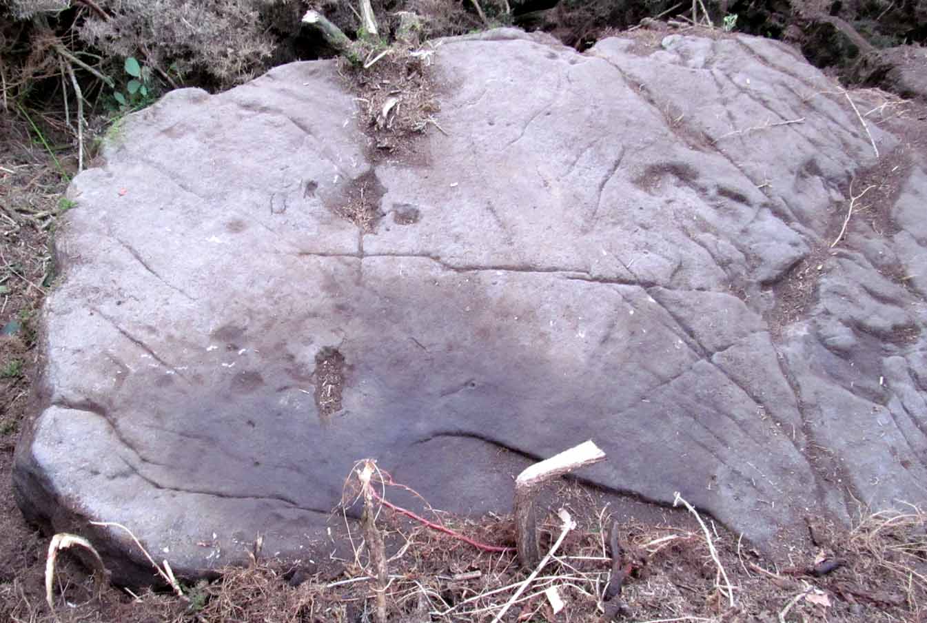
As with other carvings in this locale, the name of the stone is based on a survey done by Maarten van Hoek. (1996) It’s a pretty simplistic design within the impressive Castleton complex, found at the southeastern end of the gorse-covered rocky ridge, about 70-80 yards west of the farmhouse. It was uncovered on a visit here by Nina Harris, Paul Hornby, Frank Mercer and Lisa Samson on Sunday 19 November, 2018.
The cup-marked stoneLarge cup & arc of 3
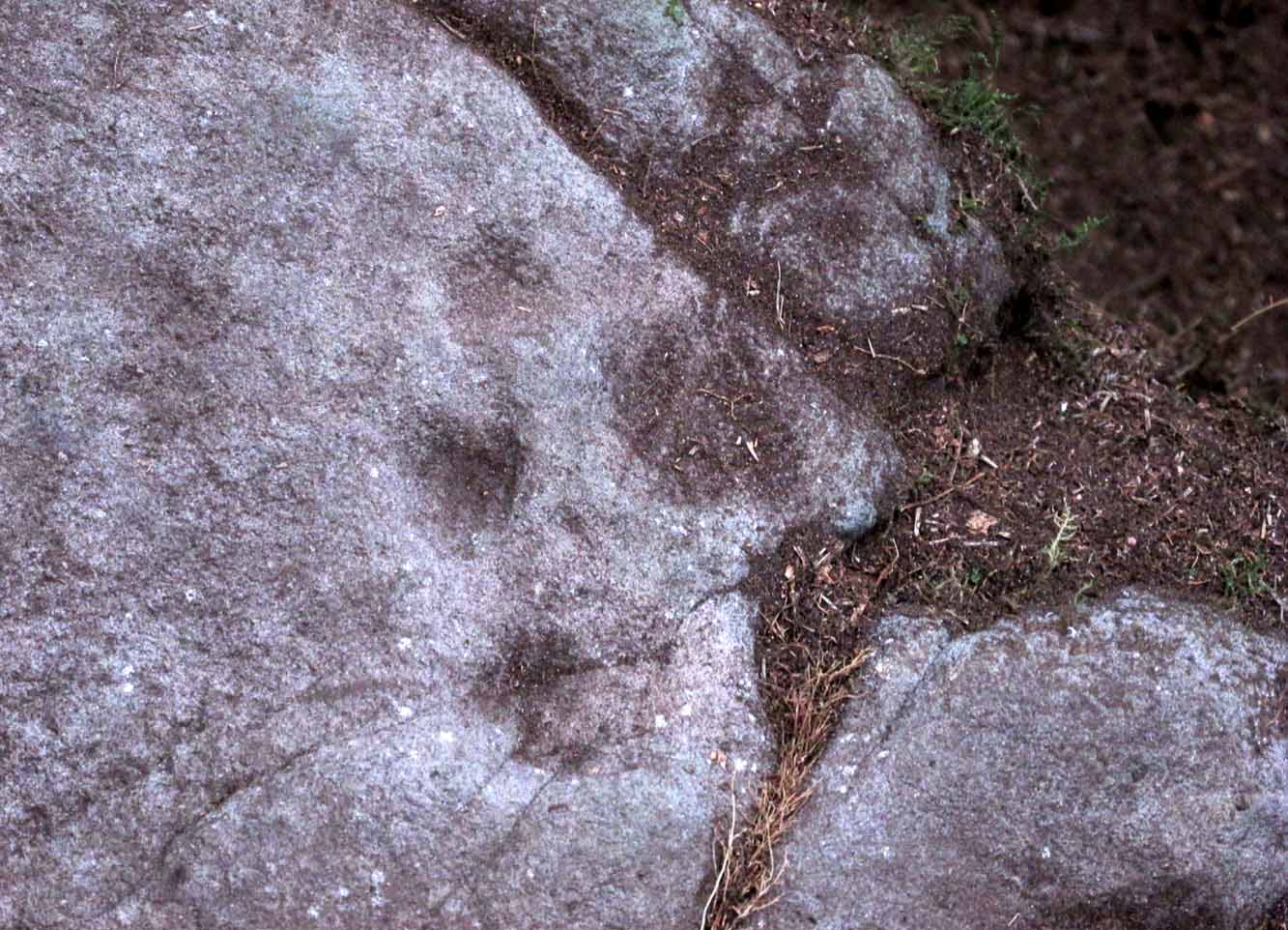
Unlike the others in the Castleton complex, this carving is probably of interest only to the hardcore petroglyph hunters. The design consists of at least ten cup-marks on the uncovered section of the rock, one of which appears to have a broken circle with two ‘entrances’ either side of it, so to speak. The most notable element in the design is close to the edge, where an arc of three cups almost corners a larger cup right at the edge. There may be more carved elements to be found on the westerly side of the stone, which was covered in deep vegetation when we came here.
References:
van Hoek, Martin A.M., “Prehistoric Rock Art around Castleton Farm, Airth, Central Scotland,” in Forth Naturalist & Historian, volume 19, 1996.
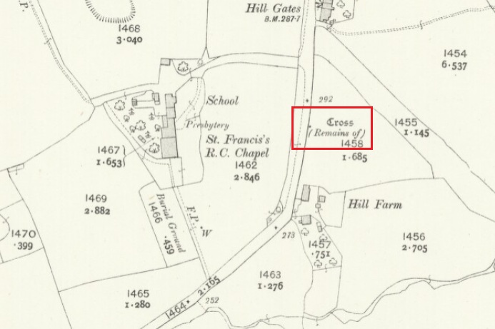
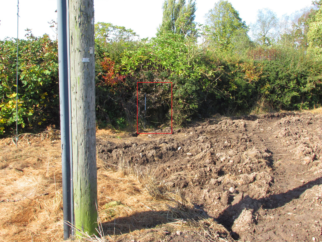
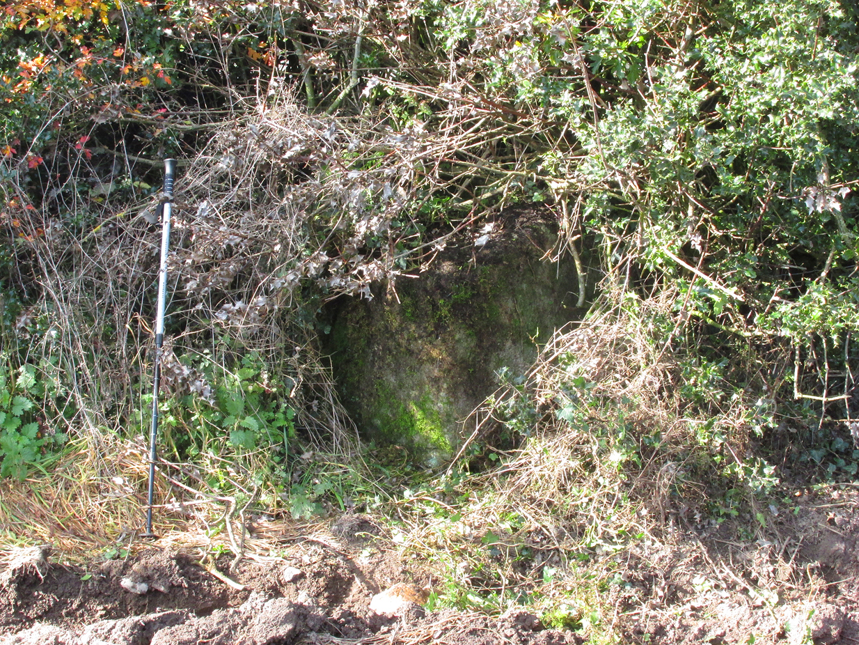
The Cross base is situated in a thick hedgerow on the east side of Horns Lane, opposite St Francis’ Hill Chapel, just to the north of and on the field side of the electricity transmission line that crosses the road at this point. It can be accessed from the field to the north by crossing the stream. In winter the Cross base is just visible from the road side through the hedge.
Archaeology & History
This cross is not described or noted by Henry Taylor in the 1906 edition of his Ancient Crosses and Holy Wells ofLancashire. All that survives is the substantial socketed base of what is likely to have been a mediaeval cross. It is almost completely hidden in the hedge, and is only accessible for ‘hands-on’ inspection from the field side of the road.
It was described by Historic England as:
‘The socket-stone of a probable wayside cross 1.0m square and 1.5m high…. Its present position in a pasture field suggests that it is not in situ.’
Cross position highlightedHidden in the boscage
Despite this description, the substantial nature of the base leads me to query why anyone would wish to move it from elsewhere. It is more likely that past land-owners have encroached on to the ancient highway, and fenced it accordingly. Maybe the Hill Chapel congregation will at some consider exposing the base on its hill crest position and insert a replica cross?
There is no record of what happened to the original Cross. According to a pamphlet describing Hill Chapel, “this house appears to have always been in Catholic hands”, but no mention is made of the Cross. A likely culprit for its destruction is the early nineteenth century Protestant fundamentalist the Reverend Richard Wilkinson.
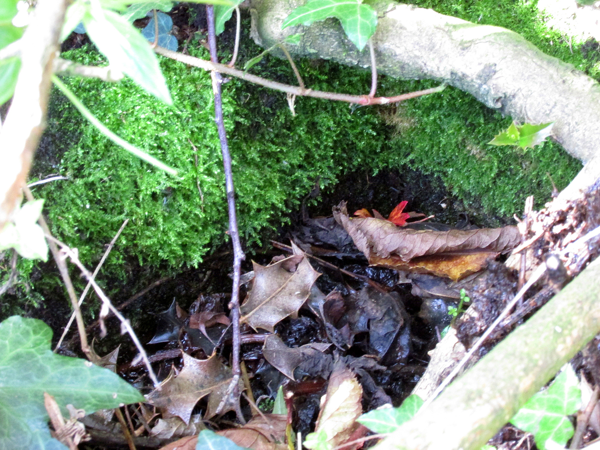
The leaf-filled cross-base
In view of the continuity of Catholic ownership and worship at the Hill Chapel site over the road since before the Reformation, and the sustained persecution suffered by local Catholics in the centuries following the Reformation, it is very unlikely that they would have drawn attention to themselves by erecting the Cross, making it almost certainly of pre-Reformation construction.
Reference:
Anonymous, Hill Chapel Goosnargh, privately published pamphlet available from Hill Chapel, n.d..