Wayside Cross: OS Grid Reference – NO 29607 02202
Also Known as;
- Stobb Cross
- Canmore ID 29950
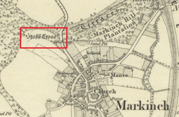
The cross is located on a bluff of land overlooking the west side of Stob Cross Road on the northern edge of Markinch.
Archaeology & History
In 1933, following a visit in 1925, the county archaeological inventory described it thus:-
Close beside the East Lodge of Balbirnie House, on a knoll 200 feet above sea-level, stands a stone known, from the nature of its sculpturings, as the “Stob Cross.” It is a somewhat mutilated rectangular slab, 7 feet 5 ½ inches in height, 2 feet broad at the base and 6 inches thick, having a plain cross carved in relief on the east and on the west face. The cross on the east is now very much damaged but sufficient remains to indicate that the arms have been 1 foot wide and that the shaft has measured 1 foot 5 inches across at the intersection. On the west face the design stands out in relief from 1 to 1 ¼ inches. The arms of the cross measure 11 ½ inches in width, and the upper limb, which tapers slightly to its extremity, is 12 ½ inches across at the point of intersection. The shaft measures 1 foot 2 inches across below the arms and widens gradually downwards to 1 foot 8 inches at the base. In 1790, when the cross was in danger of falling, the Earl of Leven had the position faced up with masonry, and the monument now stands, with its major axis north and south, on a two-stepped base of modern construction.
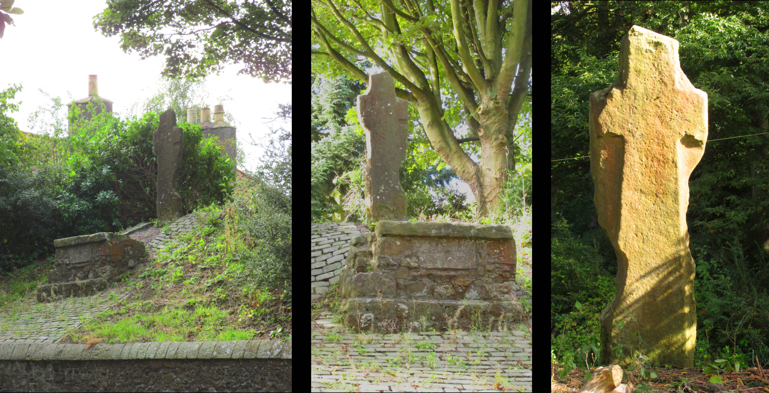
It’s certainly had a hard life, and its official designation as ‘early medieval’ leads us to suspect that it may have been a decorated Pictish cross that has had its ornamentation obliterated by Reformation iconoclasts. Those same iconoclasts may have concocted the ‘history’ recounted by Rev John Thomson (1794) in the Old Statistical Account of 1794 of what he describes as a ‘very coarse piece of work’:-
‘Vulgar tradition says, that it was erected to the memory of a gentleman, who fell on this spot, in a mortal encounter with one of his neighbours.’
Writing of Markinch, nineteenth century historian Aeneas Mackay (1896) has this to say:-
‘A cell of the Culdees was established there by one of the last Celtic bishops, and the ancient cross near Balgonie [sic] may mark its site.’
Modern place-name research ascribes Markinch as a place where horses were grazed while their owners were attending the early mediaeval courts and assemblies at Dalginch a quarter of a mile to the east, so the cross may at that time have been a waymarker. A roadside plaque describes the Cross as possibly marking the limit of an ancient sanctuary enclosure related to the church of St Drostan (known locally as St. Modrustus) in the centre of Markinch. Additionally, it was on the ancient (and recently revived) Fife Pilgrim Way from Culross to St Andrews, so would have been a wayside station for the pilgrims. which if it was a Pictish cross would have made it a target for desecration by iconoclasts. We are lucky that it has survived at all, and with the revival of the Pilgrim Way as a long distance path it will attract many new admirers.
References:
- Forbes, A.P., Kalendars of Scottish Saints, Edmonston & Douglas: Edinburgh 1872.
- Mackay, Aeneas J.G., A History of Fife and Kinross, Blackwood: Edinburgh 1896.
- Markinch Heritage Group, – http://www.markinchheritage.org.uk/Index.asp?MainID=5250
- Royal Commission, Inventory of Fife, Kinross & Clackmannan, HMSO: Edinburgh 1933.
- Taylor, Simon & Márkus, Gilbert, The Place Names of Fife – volume 2, Shaun Tyas: Donnington 2013.
- Thomson, Rev John. The Statistical Account of Scotland – volume 12, Creech: Edinburgh 1794.
© Paul T. Hornby, The Northern Antiquarian, 2020