Take the B934 road south, uphill, out of Dunning, for 2.1 miles (3.4km), past Kippen, past Pitmeadow and past Quilts. It’s the track to Knowes that you’re after! Along this track, keep to the field-side on your right, following the edge of the fencing until you reach the small copse of trees. At the far side of the trees a gate takes you into the field with the standing stone, which is just over 100 yards to the north. You can’t miss it!
Archaeology & History
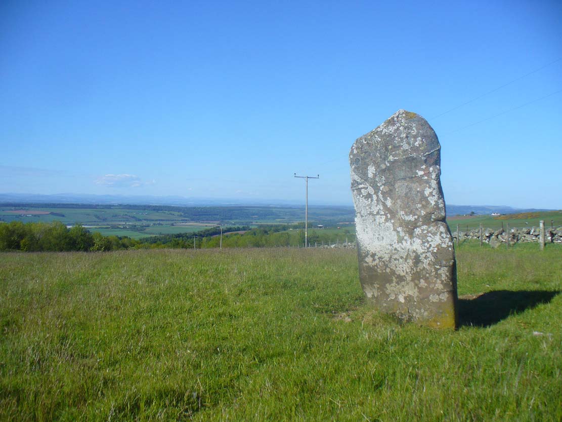
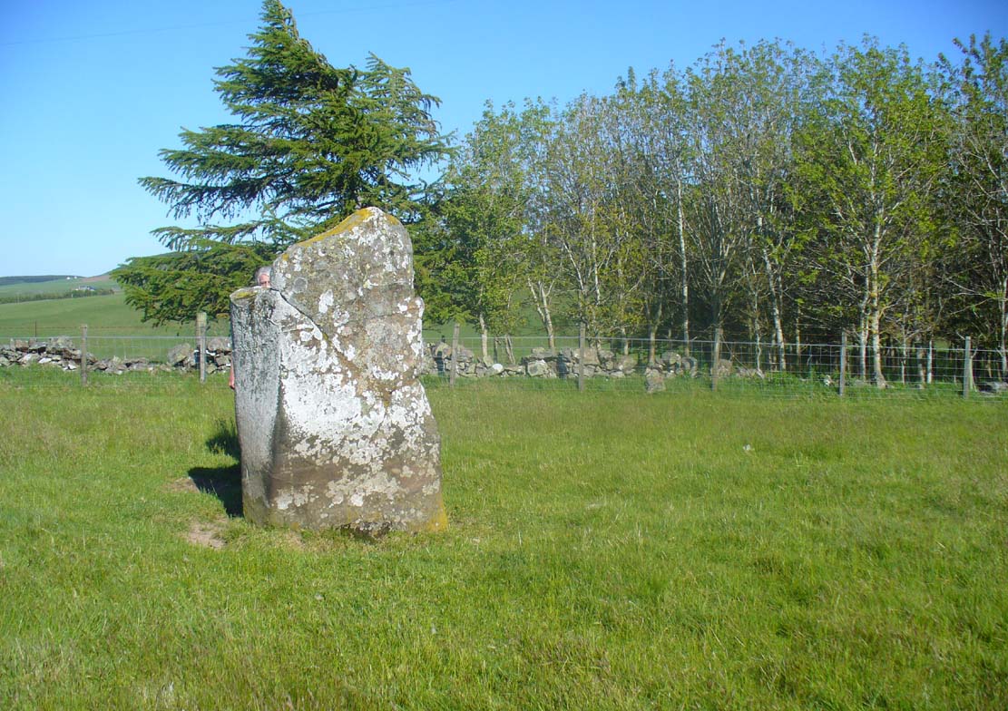
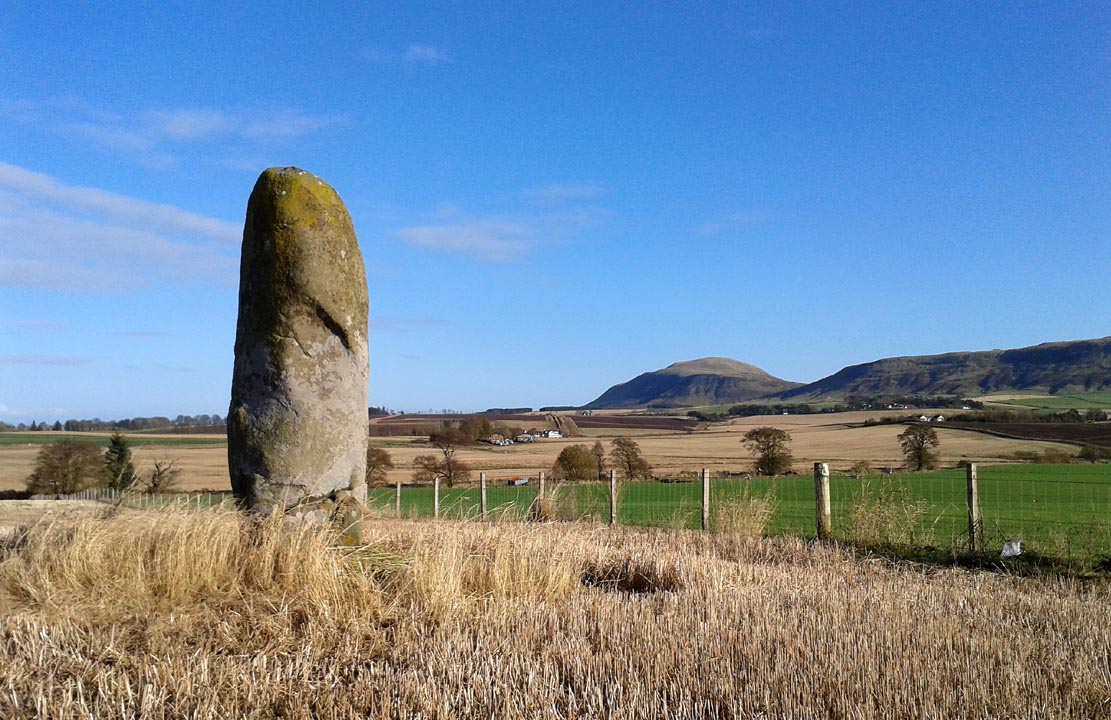
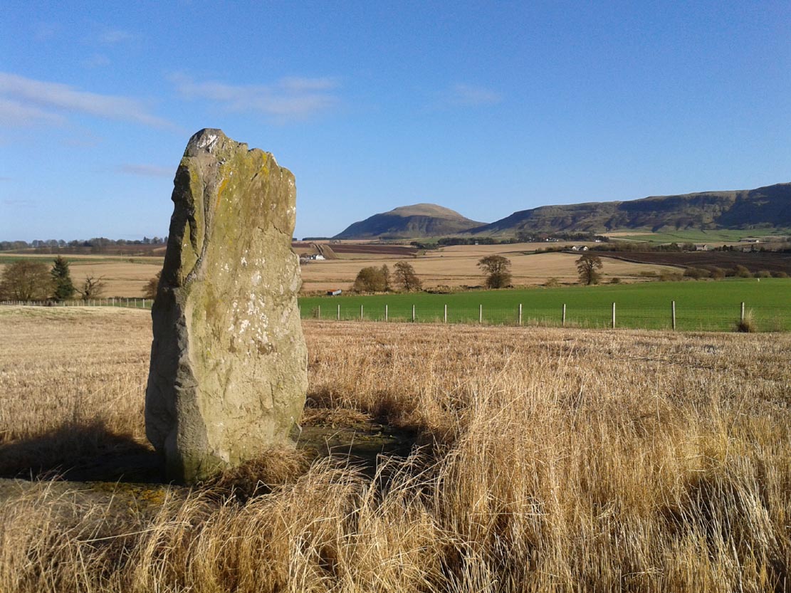
Although mentioned in several folklore works and just a couple of archaeology tomes, almost nothing has been written about this large upright standing stone. A very bulky stone nearly seven feet tall, it has been broken into pieces at sometime in the recent past but, thankfully, good locals put the stone back together and placed it upright once again. Its position in the landscape is quite superb, overlooking the lowlands of Tayside below and then far into the rising mountains of Perthshire and beyond, easy fifty miles or more.
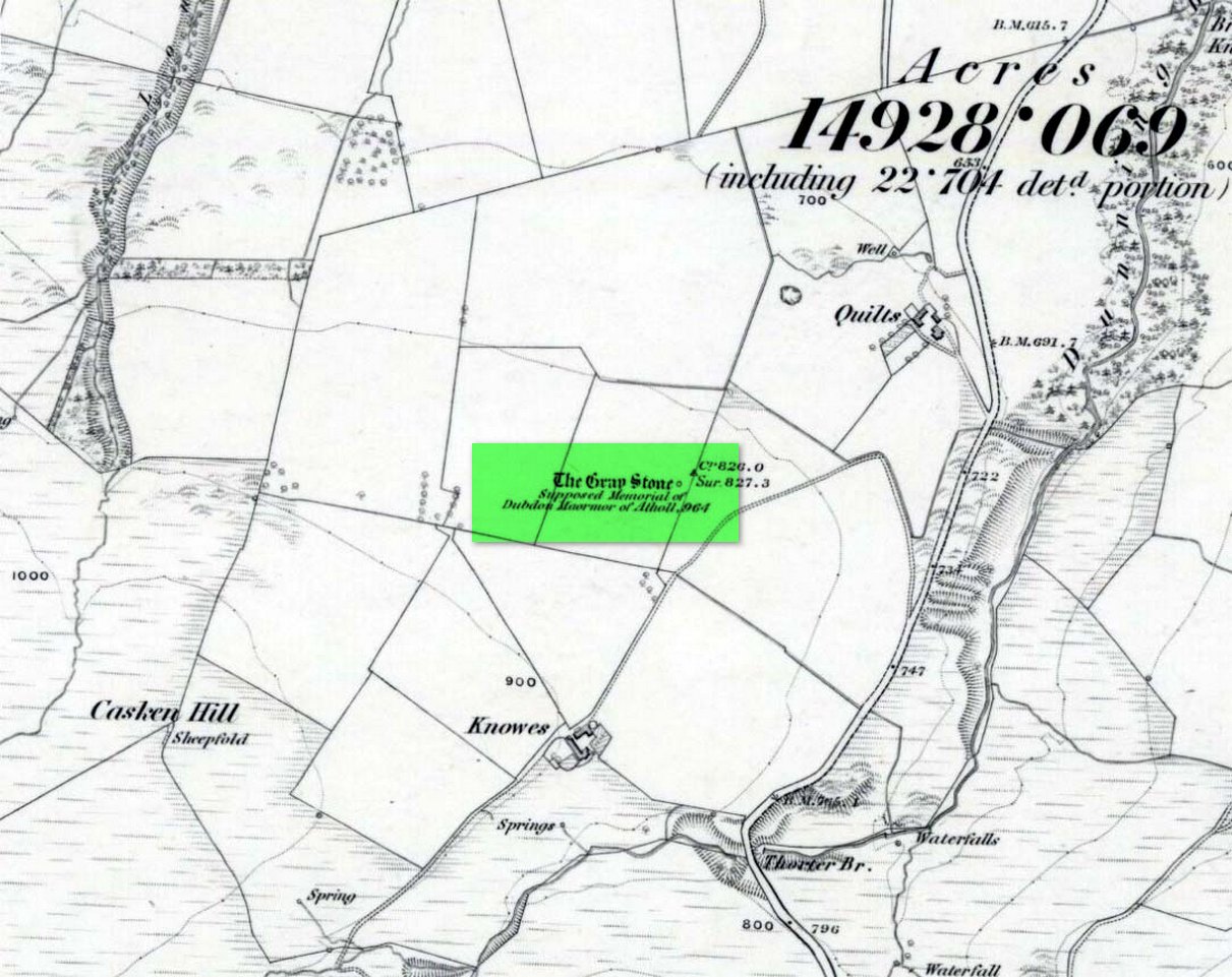
Grey Stone, looking southGray Stone on 1866 map
Shown on the earliest Ordnance Survey map of the area, the name of the stone is somewhat of a puzzle, for in a lot of cases ‘gray’ stones are found on local boundary lines—indeed, the name gray stone and boundary stone are interchangeable in many cases—yet the nearest boundary from here is some distance to the east. It may simply relate to the colour of the rock (although this is unlikely). Whatever its reason, it’s an impressive stone and is well worth checking out!
Folklore
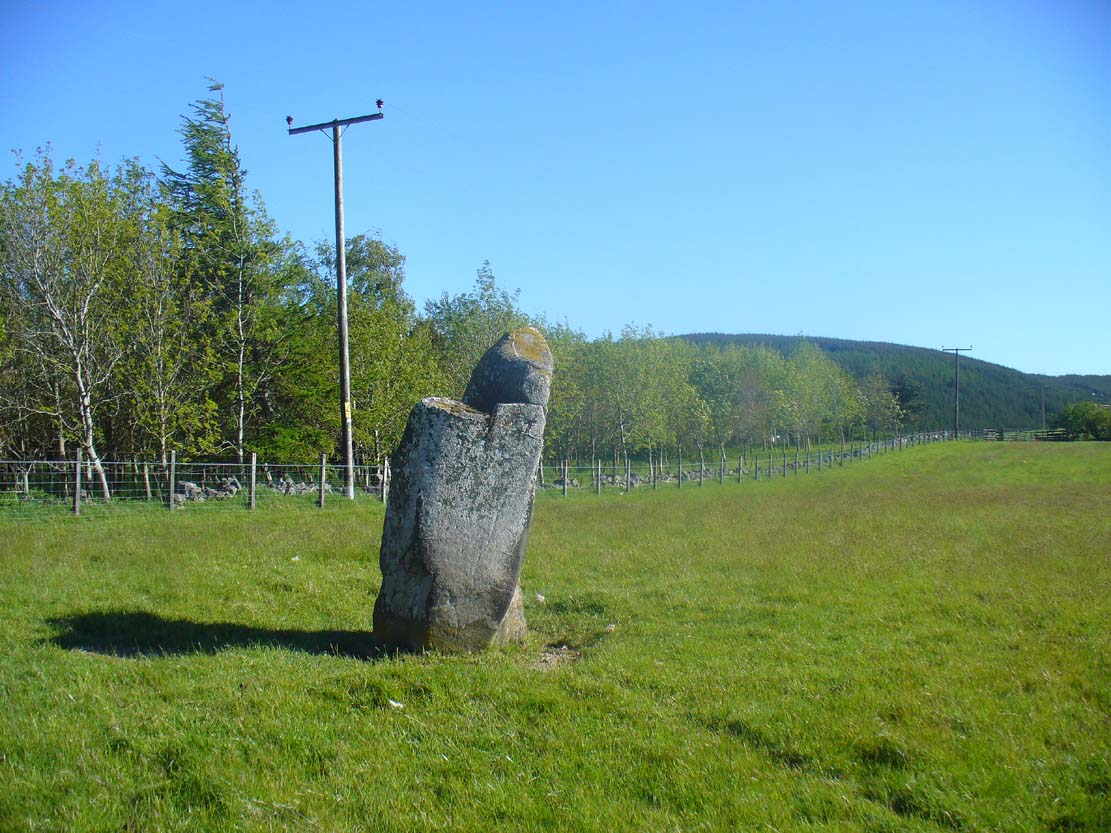
Gray Stone, looking east
The local farmer told that the field where the Grey Stone lives was known as the Big Stane Field. Makes sense! Legend has it that the Gray Stone was the burial place of Maormor, the Steward of Atholl in the Battle of Duncrub, after dying in Thanes Field (Watson 1995), on land to the north of Dunning village in 964-5 CE.
References:
Holder, Geoff, The Guide to Mysterious Perthshire, History Press 2006.
McKerracher, Archie, Perthshire in History and Legend, John Donald: Edinburgh 1988.
Swarbrick, Olaf, A Gazetteer of Prehistoric Standing Stones in Great Britain, BAR: Oxford 2012.
Watson, Angus, The Ochils: Placenames, History, Tradition, PKDC: Perth 1995.
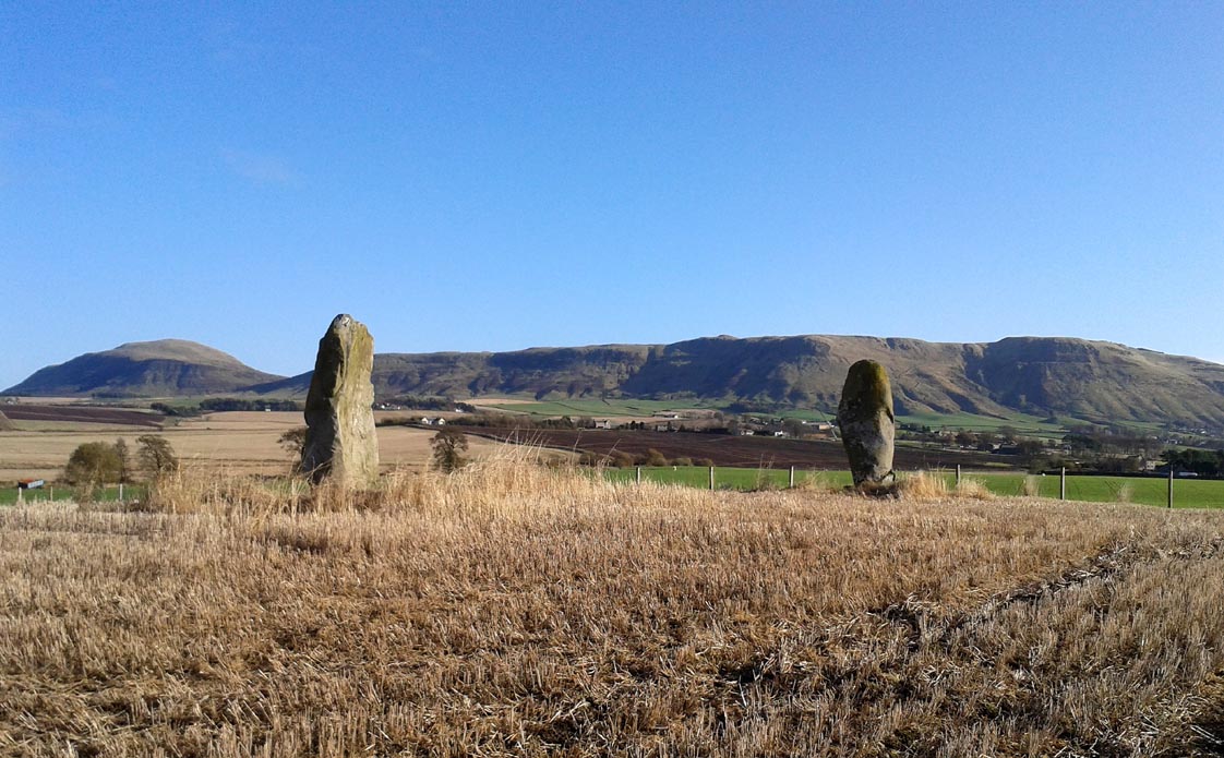
Drive from Milnathort SE down the A911 road towards Balgedie and Scotlandwell. About a mile out of the village, keep your eyes peeled on the farmed fields on your left. You’ll notice the standing stones a few hundred yards ahead and, if you, see them in time, will be able to park up by the track on your left a coupla hundred yards before Orwell Farm. Ensure you visit this site between October and March – otherwise the fields are in full crop.
Archaeology & History
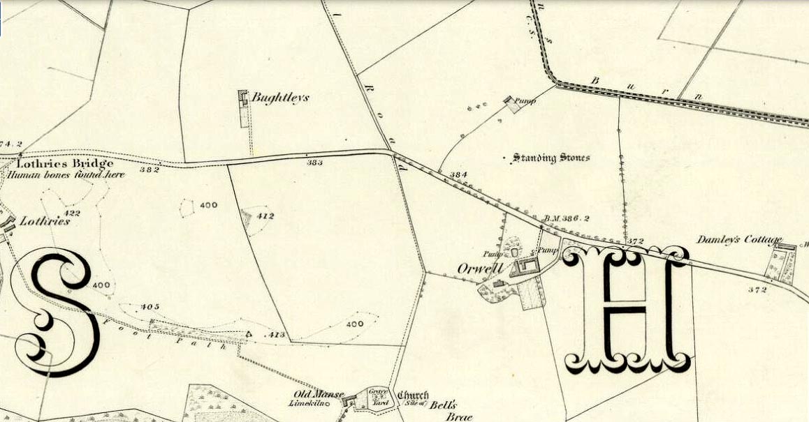
Stones marked on the 1857 map
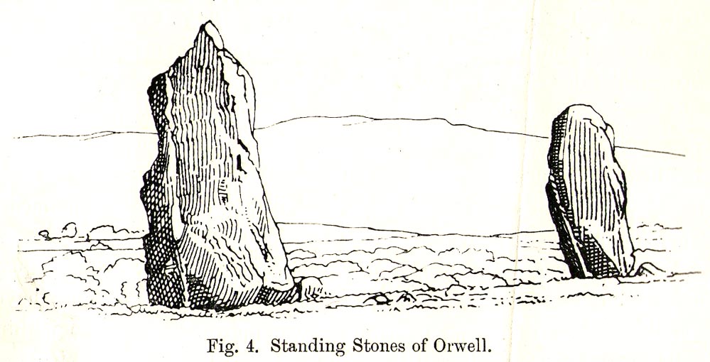
These are impressive standing stones by anybody’s standards. Although we have two impressive uprights today on the highest point in the potato fields, in the 19th century the place-name writer Liddall (1896) told that “in this district are still three large pillar stones known as the Standing Stones of Orwell.” (my italics) Their existence was recorded, he said, in early topographical accounts in an obsolete place-name Mawcloych, or “place of the stones.” But if there were three standing stones here, they must have stood prior to the article written by the pseudonymous “W.H.”, who described them in the October edition of The Scottish Journal in 1847, saying:
“About half-a-mile above the old (Orwell) churchyard, in a field by the roadside, are two large upright stones, known as “the Standing Stones of Orwell.” They are placed east and west of each other about fifteen yards apart—that to the west is flat, and about six feet in height—the one to the east is of a round form, tapering slightly to the ground, and stands nine feet high. The latter, although still of considerable size, has lost somewhat of its circumference within the last ten years, and, at the present moment, there is a large crack down one side, which, by the action of the weather, will lead to a further diminution of its bulk. It has not been ascertained to what depth these stones are embedded in the earth, but it must be considerable, in order to retain them in the position they occupy.
“The common belief is, that these stones are of Danish origin, erected in commemoration of a victory, or to mark the spot where those who had fallen in battle were interred. This supposition is so far countenanced by the fact that a stone coffin, of large size, was found on digging up the space between the stones. Similar coffins have also been turned up in the same field, and, ten or twelve years ago, the ground was dug up in several places by a neighbouring proprietor, when large quantities of bones, much decomposed and mixed with charcoal, were discovered.”
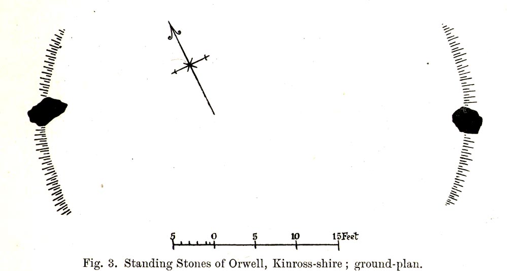
Fred Coles 1906 ground-plan
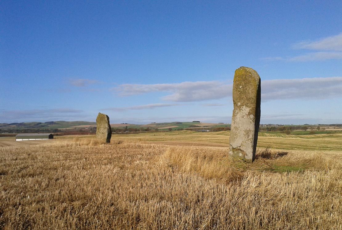
Orwell Stones, looking north
This early description telling of the poor condition of one of the stones presaged its eventual fall in the late 1960s; but this thankfully led to an archaeological evaluation which gave us more information about the site. Before this however, the great northern antiquarian Fred Coles (1906) visited the stones in August 1904, describing them with his usual meritorious detail, telling:
“They stand on a very gently rising ground, the space between them and for some distance to the south being somewhat higher than the surrounding field. In ground plan they are related as shown (attached). The east stone is the higher, standing 9 feet 8 inches clear of theground, smooth-sided and hexagonal. At the base its girth is 9 feet 9 inches, swelling up at the 5-foot level into 10 feet 8 inches. The West Stone, very rugged and angular, is 7 feet 5 inches in height, girths at the base 11 feet 1 inch, and at about 3 feet upwards, 10 feet 5 inches, its broadest side facing the East Stone. Both are of whinstone. The shortest distance between the two Stones is in a line nearly north-west, and measures 46 feet 10 inches.
“Mr R. Kilgour, one of the oldest residents of Kinross, showed me a fine partially flattened oval pebble of dark reddish quartzite, measuring 5 inches by 2⅞ inches, which he found in the ground between these two Stones. The abrasion at each end clearly shows that this pebble has been used as a pounder.
“In a book which to some extent deals with local antiquities, occurs the following passage with reference to these two Standing Stones: ‘In the same field stone coffins have occasionally been turned up by the plough; and, about the beginning of the 19th century, the ground was in many places dug up by the neighbouring proprietor, when quantities of bones much decomposed and mixed with charcoal were discovered.’”
But after the west stone fell down, J.N.G. Ritchie (1972) and his team turned up to resurrect it—and also check out what might be underneath it. His initial notes of the findings were published in Discovery & Excavation Scotland, which said:
“Excavation at the bases of these two standing stones…was undertaken prior to the re-erection of the W stone and to the embedding of both stones in cement. The original position of the fallen stone could be detected only as a slight hollow in the natural gravel, but as this corresponded with the position of the stone on Coles’ plan…the stone could be re-positioned comparatively accurately.
“A cremation deposit was found in an insubstantial stone setting in a scoop in the natural gravel some 0.5m S of the stone. The E stone, which is an impressive whinstone 3.8m in total height, had been set up in a hole 1.5m x 1.4m and 0.75m in depth. Within the pit on the SW side of the stone there was an unusual two-storeyed cremation deposit; the lower cremation was contained within a rough setting of stones with one side formed by the standing stone itself, and was covered by a flat slab. On this slab and again surrounded by a setting of small stones was the upper cremation. It seems most likely that these were inserted into the stone hole at the time of the erection of the stone. Another cremation was found at the lip of the stone hole on the SE side. The discovery of cists and cremation patches in the same field in the early 19th century suggests that the stones have acted as a focus for such burials.”
The southeasterly stone
The northwesterly stone
Ritchie (1982) later wrote how they had found “burnt dog and pig bones with the lower cremation deposit,” implying “rituals” at the site. He even posited how such deposits at standing stones “may have a bearing on their postulated use as astonomical markers,” although Alexander Thom’s (1990) exploration of the Orwell stones indicated no archaeoastronomy here. So it seems very obvious that these giant monoliths were markers for a neolithic and/or Bronze Age cemetery or necropolis in prehistoric times. Aubrey Burl (1993) defined the stones here as having “an Irish setting, with the east emphasized, as alway, by the taller stone.”
Fred Coles’ 1906 drawing
Unmentioned by the archaeologists in all of the references I have at hand, is the probable relationship the Orwell stones had with the rising background of the Lomond Hills to the east, with its archaic legends of cailleach, neolithic tomb creations and other geomantic indicators. These elements (and more) need to be explored more diligently by forthcoming students. It’s a remarkable setting as far as I’m concerned!
References:
Burl, Aubrey, “Pi in the Sky”, in Douglas C. Heggie’s Archaeoastronomy in the Old World, Cambridge University Press 1982.
Burl, Aubrey, From Carnac to Callanish, Yale University Press 1993.
Ritchie, J.N.G.,”Orwell Standing Stones,” in Discovery & Excavation in Scotland, 1972.
Ritchie, J.N.G., “Archaeology and Astronomy: An Archaeological View”, in Douglas C. Heggie’s Archaeoastronomy in the Old World, Cambridge University Press 1982.
Royal Commission on the Ancient & Historical Monuments of Scotland, Fife, Kinross and Clackmannan, HMSO: Edinburgh 1933.
Simpkins, John Ewart, County Folklore – volume VII: Examples of Printed Folk-Lore Concerning Fife, with some Notes on Clackmannan and Kinross-Shires, Folk-Lore Society: London 1914.
Thom, A., Thom, A.S. & Burl, Aubrey, Stone Rows and Standing Stones – volume 2, BAR: Oxford 1990.
“W.H.”, “A Ramble in Kinross-shire,” in The Scottish Journal of Topography, Antiquities, Traditions, volume 1, 1848.
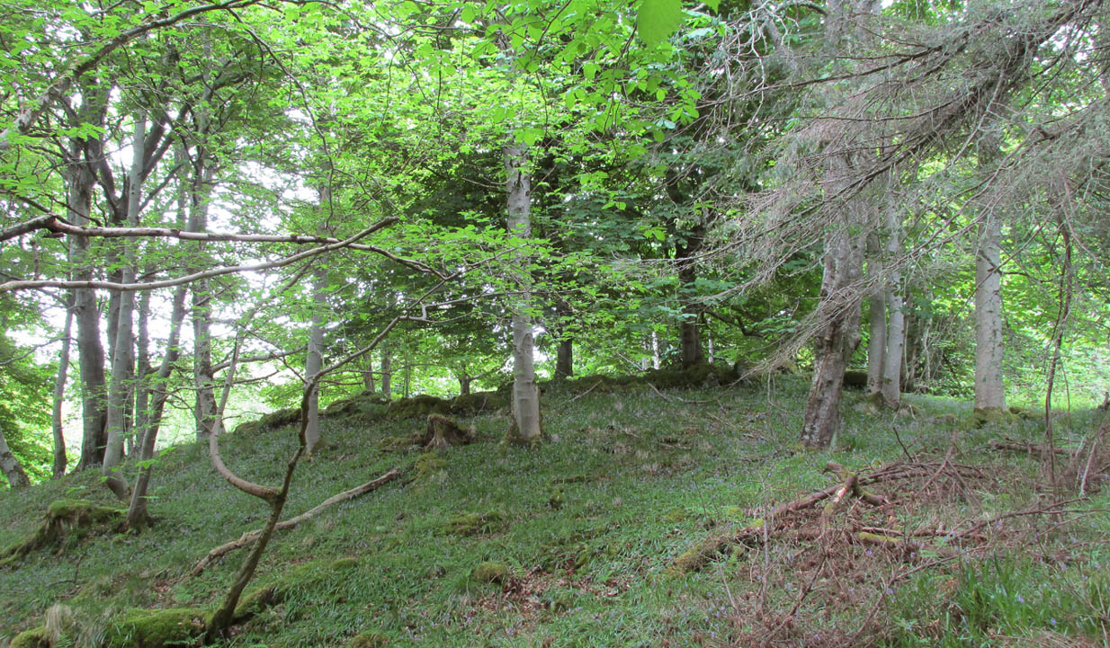
I approached this by walking along the B8438 road northwest out of Tongue village, towards the road-crossing over the Kyle of Tongue. There’s a small tiny road on the right (easily missed) nearly a mile out, just as the road starts to bend, which leads you down to Tongue House. Go along here for about 325 yards (300m) and just as the road bends to the left, walk into the woods. Keep straight forward, following the low-level stream, and when you see the buildings ahead of you, veer diagonally upslope until you hit the large Tongue Burn. Cross this and walk uphill to the tree-covered knoll ahead. You’re there!
Archaeology & History
…and again, looking north
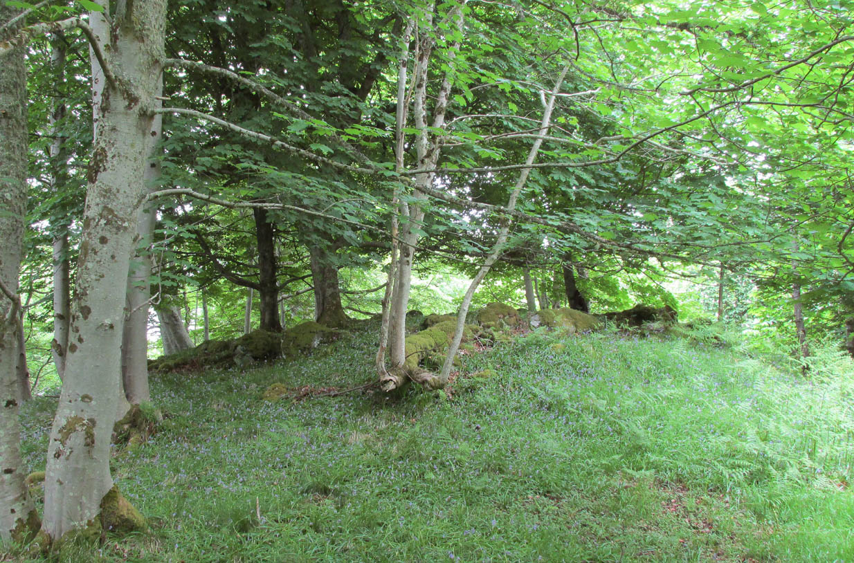
From the descriptions I’d read of this site, I wasn’t expecting much at all—but it was much better than I anticipated, and in a beautiful woodland setting too. Admittedly the site is much overgrown, but the overall size, edges and outline of the tomb is easily discernible. In pacing across it, from outer-edge to outer-edge, it measured 18 yards by 19 yards across. All round the edges are many overgrown tumbles of smaller rocks which obviously had been part of the cairn in previous centuries; but it is primarily defined by the larger earthfast rocks at the very top of the natural knoll in the trees, all of them covered in deep mosses.
The site was first mentioned in James Horsburgh’s (1870) survey of the region. He explored a small section of the monument and, upon digging, found a chamber therein—defined by Audrey Henshall (1963) as “a single compartment chamber”—telling us:
“A little to the south of Tongue House, and near the fountain head that supplies it with water, there is the chamber of a cairn of the same description as that near Skelpick, but rather smaller; on clearing it out, I found that one of the large upright stones had two holes bored artificially a short way into each of its sides, but not quite opposite, the holes were about 3 inches diameter.”
However, these internal structures have not been seen since and in Henshall & Ritchie’s (1995) catalogue of Sutherland’s giant tombs, there is some confusion over the definition of the structure itself, questioning whether or not it was indeed a chambered tomb.
“The ‘chambered cairn’ is a circular stone structure overgrown with small trees and covered in leaf-litter and moss. A kerb about 15m in diameter can be traced for much of the circuit. The kerb is of unusually substantial and closely-set boulders which have the appearance of the base of a massive wall such as is inappropriate for a dun or a broch rather than a cairn. The interior is filled with loose stones including some quite large boulders, roughly to the level of the top of the kerb. There is no indication that these boulders have formed part of a neolithic chamber or that the structure was a cairn. There seem to be three possibilities: that the structure is not Horsburgh’s cairn; that the structure is that which he investigated but that he was mistaken in regarding it as a chambered cairn; that the writers are mistaken in identifying the structure as a ruined broch or dun.”
Despite this, the general consensus today is that the monument is indeed a chambered cairn.
References:
Henshall, Audrey S., The Chambered Tombs of Scotland – 2 volumes, Edinburgh University Press 1963 & 1972.
Henshall, Audrey S. & Ritchie, J.N.G, The Chambered Cairns of Sutherland, Edinburgh University Press 1995.
Royal Commission on Ancient & Historical Monuments, Scotland, Second report and inventory of monuments and constructions in the county of Sutherland. HMSO: Edinburgh 1911.
A recent visit to try find this intricate carving—the only one of its kind in Clackmannanshire—proved unsuccessful, and so I add it here in the hope that someone might know where it is and bring it back to light. It looked like quite an impressive petroglyph. If the stone isn’t hiding in undergrowth at the edge of someone’s garden, it may well have been destroyed—which would be appalling. As a unique design, this important carving should have been preserved. Even when the Victorian explorers found it, the covering stone circle had been greatly damaged and many stones in the ring had been removed. This carved stone remained intact however. When Mr R. Robertson (1895) and his friend visited the site, it was covered in sand and dirt and had fallen to the side of an internal cist:
“On clearing this away a remarkable feature was brought to light. The block was found to be elaborately ornamented on its sides and upper surface, with rings, spirals and lines. The labour of cutting these in the hard granite with primitive tools of the period must have been very great. Several successful photos of the stone and its carvings were taken by Provost Westwood, Dollar…. This stone has now been removed to the vicinity of Tillicoultry for safety.”
In the same article, George Black told slightly more of the design:
“The covering stone of the cist…bears on the face a series of concentric circles, and spirals springing from one of the groups of circles, Four grooves also unite the same set of circles with the left-hand edge of the stone. On the edge shown in the photograph there is another group, consisting of two concentric circles. The unevenness of the surface of the stone appears to have been of no moment to the sculptor of the circles, as the incisions follow the surface into its sinuosities and depressions.”
Not long after Robertson & Black’s visit, the great megalithomaniac Fred Coles (1899) came here—and he found that the “spirals” that Mr Black described were nothing of the sort.
“The huge irregularly-shaped diorite boulder which covered the cist has several cup-and-ring marks on one face and one side…. These marks are now, so I was informed when inspecting them, very much less distinct than they were when the photograph was taken (above) in 1894. It would be difficult now to describe the incised markings with accuracy; it is difficult even to see them when wet. But…I must take exception to the term ‘spirals’ as applied to any of these ‘rings.’ There are three groups of rings so placed as to make the outermost ring in each group touch that of the others (not an uncommon form), but there is no one true volute.
“…What is more noteworthy is the group of four long parallel, nearly perpendicular grooves issuing (probably) from the outermost ring of the group of five rings, and ending at the edge of the boulder.”
Alison Young’s 1937 sketch
Cole also noted that the carvings were to be found on the upper surface of the stone. It would seem very probable that the excessive erosion which Cole described was due to the fact that the stone was, many centuries earlier, exposed to the elements within the stone circle and not buried as it later came to be. It makes sense.
The excessive erosion was spoken of by the Royal Commission (1933) lads, aswell as the last person to describe the site, Ronald W.B. Morris (1981), who said that during his visits here between 1966-75,
“the author has only found traces of possible cups visible on the rough surface, which has flaked badly.”
Morris (1981) said that the stone measured “1½m by 1¾m by ½m (5½ft x 4½ft x 2ft)”—and was last known to be some 10 yards NW of the Tillicoultry House cottage, but we could locate no trace of the stone or its carving. If anyone is aware of the whereabouts or fate of this important neolithic carving, please let us know.
Morris, Ronald W.B., “The Cup-and-Ring and Similar Early Sculptures of Scotland; Part 2 – The Rest of Scotland except Kintyre,” in Transactions of the Ancient Monuments Society, volume 16, 1969.
Morris, Ronald W.B., The Prehistoric Rock Art of Southern Scotland, BAR: Oxford 1981.
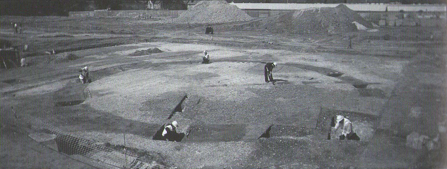
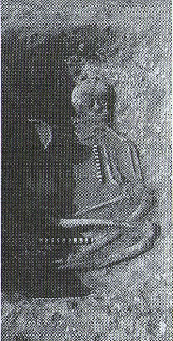
Tumulus (destroyed): OS Grid Reference – TR 389 661
Archaeology & History
A little-known site which archaeologist Brian Philp (2002) called “a Bronze Age barrow”. When the old Greyhound Stadium at Ramsgate was being demolished for a new housing estate, planning conditions required an archaeological evaluation and so Philps and his team set out to explore the area in February 2000. They weren’t to be disappointed! Unearthing a ring ditch nearly 20 yards (18m) across, they found that it had been cut into the local chalk some three feet deep. Although there was no obvious entrance, the northeast section of the ancient monument,
“was found to be covered by a compact layer of flint metalling. This was a wide and well-made surface or platform, perhaps of Iron Age date, which clearly covered the silted ring-ditch, Nearby was a large male skeleton in a very shallow grave and with head missing due to later disturbances.”
The excavated ring ditch (after Philp 2002)
The crouched skeleton (after Philp 2002)
But the best was yet to come! In another section of the circular monument, cut into the chalk itself, they found a complete male skeleton laid in typical foetus position, on its left side, with a large beaker pot positioned in front of it. These beakers are pretty common and tend to be seen as once holding food enabling the dead to eat in their journey into the Land of the Dead. It makes sense. The entire monument has since been completely destroyed.
References:
Philp, Brian, Archaeology in the Front Line, KARU: Dover 2002.
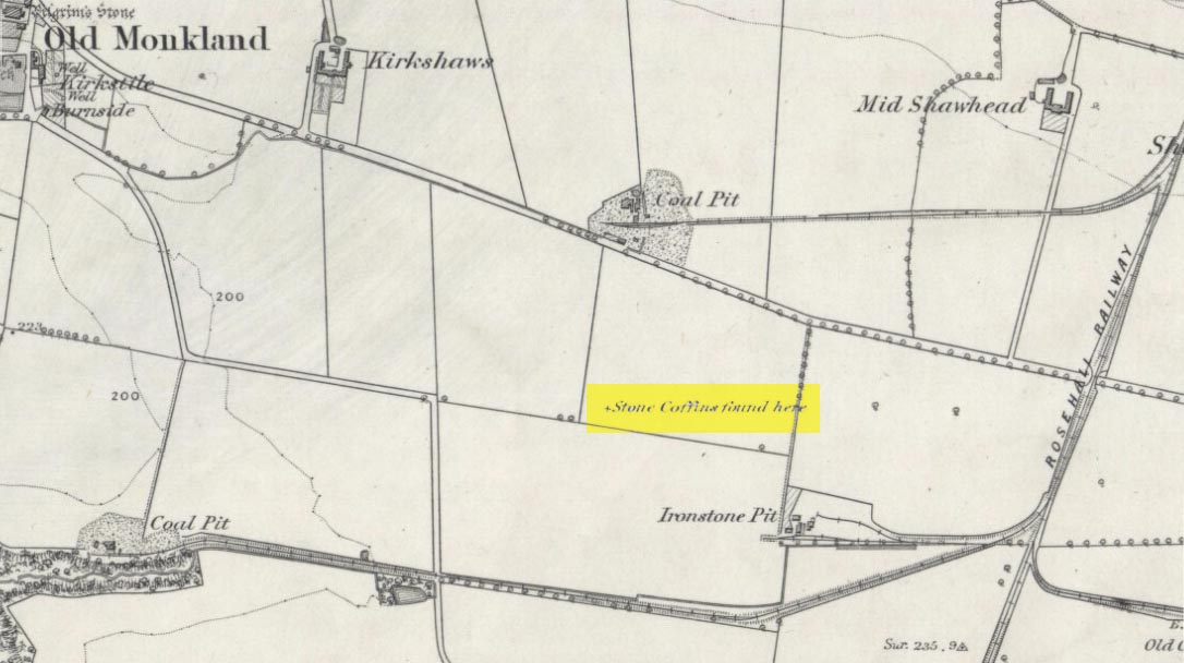
On the flat meadowlands below the slopes of Old Monkland, half-a-mile southeast of the legendary Pilgrim’s Stone, an old mound once lived. It may have been here for thousands of years but, with the encroachment of the toxic Industrialists, its time was coming to an end. The mound was levelled in 1832 and, beneath it, relics from a truly ancient past were unearthed – and destroyed of course. The account of its demise was told in the Glasgow Evening Post of May 26 that year. Many years later, the Royal Commission (1978) lads unearthed the information and included the site in their inventory for prehistoric sites in Lanarkshire. They told:
“In 1832 four cists were discovered during the levelling of a small mound 900m SE of Old Monkland Church. The cists, which measured about 1m by 0.6m, contained the remains of crouched inhumations, two of them double burials with the skulls at opposite ends of the cists. A stone hammer-head and a coin were found in one cist, the latter no doubt indicating subsequent disturbance. There is now no sign of the site, and it is not certain from the report whether the cists were inserted into a small natural mound or were covered by a barrow.
“The present farmer states that his father discovered a single cist during ploughing in the same field; it contained a pottery vessel which the landowner, Mr Sholto Douglas, was thought to have presented to a museum, but it cannot now be traced.”
References:
Royal Commission on the Ancient & Historical Monuments of Scotland, Lanarkshire: An Inventory of the Prehistoric and Roman Monuments, HMSO: Edinburgh 1978.
The location of what was, in all likelihood, a small Bronze Age burial on the edge of old Shotley Bridge (as it was in the mid-19th century) remains a mystery. It’s likely that the position of the site is now beneath someone’s house in the town. Its existence was thankfully recorded in correspondence between a “Mr. John Dixon, of the Engineer’s Office, Consett Ironworks,” and the great John Collingwood Bruce. Dixon’s letter dated October 13, 1856, told:
“I take the liberty of informing you of the discovery of a coffin, of some description or other, in a field near ShotleyBridge. I have visited the place and enclose a sketch² made on the spot as it appeared when I saw it. Some workmen were excavating sand and came upon it about a foot beneath the surface. The only remains that we can ascertain to have been in it, are a few pieces of bone, barely recognizable as such, and now in the hands of Dr.Renton. I have not yet seen them. He tells me that one fragment resembles a portion of a skull, but that they are in such small pieces it is difficult to say what they are. I shall endeavour to get a piece — as, if the surface remains, I apprehend we shall be able to say whether they are human or not. Possibly it may never have been a human coffin —though from the paved bottom and the appearance of great age the stones possess, and also the bearing NW and SE, I am inclined to think it must be one. The dry situation — a sloping hillside — would tend to preserve the remains of bones. I cannot hear of any urns, or the fragments of any, having been found in it. They may, if ever there were any, have been destroyed. The coffin may have been opened before, and rifled — say hundreds of years ago. It seems unaccountably short — as I believe the older ones are generally distinguished by their great size; but it may have been, and probably was, merely a receptacle for burnt remains, either in urns or not. The paving I mentioned had all disappeared when I saw it. As it consisted of small stones, they had doubtfully been carried away. Not being an antiquarian, or skilled in antiquarian lore, I cannot do more than form an idea about it, but shall be glad to hear your opinion at any time you may find it convenient.”
In a second letter, replying to Mr Bruce’s enquiries, Dixon added that a piece of flint had been found amongst the debris which, he thought,
“might possibly turn out to be part of an ancient weapon; and if so, might lead to some solution of the question.”
As Dr. Bruce pointed out: many ancient British graves were not uncommonly as short as three feet. In so called “rude times it would seem that a grave was made much shorter than the body—which was doubled up, and thrust in.” It was his opinion that the grave here was prehistoric. We have to agree with him. But where exactly was this place? Does anyone know…?
References:
Anon., “Discovery at Shotley Bridge,” in Proceedings Society of Antiquaries Newcastle-upon-Tyne, volume 1, no.22, 1856.
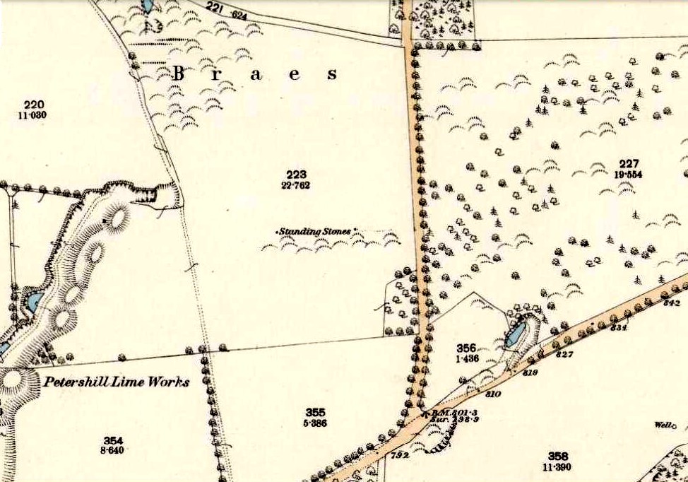
Various ways to get here: from Bathgate either take the Drumcross Road eastwards and up, or north up the Puir Wife’s Brae till you reach the crossroads where, upon the hillock north, you’ll see the old stone standing on the ridge. If you come down from Cairnpapple Hill (as most visitors are likely to do), go south for more than a mile and keep your eyes peeled in the fields to your right, shortly before the staggered crossroad. You can’t really miss it.
Archaeology & History
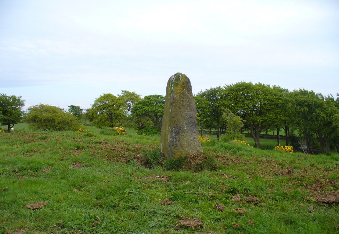
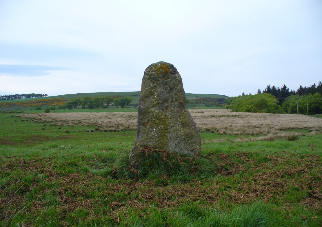
Gala Braes standing stone
About a mile south of the superb Cairnpapple Hill, in a well-manured field at the edge of a small ridge with a vast view to the south and west, this now-solitary standing stone lives quietly and alone, gazing over its old landscape. Standing about 5½ feet tall, it seems as if the monolith has been split along its southern side at some time in the not-too-distant past, leaving a damaged wedge-shaped monolith, with one very thin eastern edge and a wider western side. The stone itself was erected to align roughly north-south-east-west.
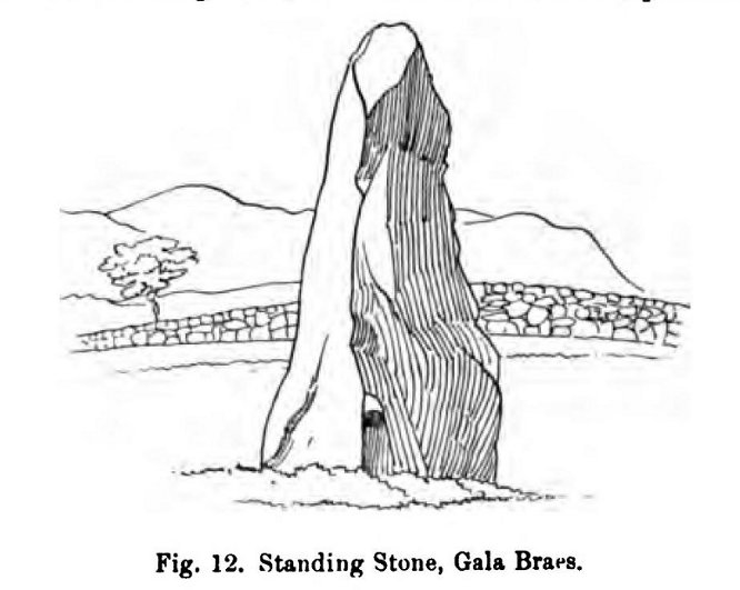
The monolith was first shown on the 1854 Ordnance Survey map of the region, along with its fallen companion (Gala Braes 2) nearly 75 yards to the west, but descriptions of the place by antiquarians are scarce. Not until Fred Coles (1903) visited here did we gain a decent account. He wrote:
“I examined this site in August 1902. It is about a mile to the east of Bathgate, and occupies the summit of a ridge extending some 300 feet westwards of the byroad that branches off due N, near the farm of Clinkingstane. The ridge is about 850 feet above sea-level. On reaching it, I found but one Standing Stone,—a rough whinstone boulder, split very unevenly, and jagged on the south side, very smooth on the two shorter sides, and girthing at the base 10 feet 5 inches. The longest edge trends WNW and ESE. It stands 5 feet 3 inches high and occupies the highest spot on the ridge.”
Whilst Mr Coles was pottering about, the courteous local farmer approached him and they began chatting about the old place—as tends to happen more than often in olde Scotland. When he,
“…asked if any digging had ever been made at either of these stones, Mr Carlaw replied that many years ago an old Bathgate worthy known as “The Apostle” persuaded his (Carlaw’s) father to dig at the base of the upper Standing Stone (the one at present erect), and they found human bones. The farm of Gala Braes has been in the tenancy of a Carlaw for upwards of a century.”
Whatever became of the old bones isn’t known. A few years later, the Royal Commission (1929) lads bimbled over to check the place out and found that it was still very much as Coles had described more than twenty years earlier, but added, “it bears no trace of sculpture.” This has since changed. Faint outlines of lettering, seemingly only a hundred years old perhaps, have been etched onto its northern face. As for the etymology of this place, Coles (1903) suggested:
“Assuming, however, that the bones found at the upper Stone were human, and taking cognisance of the fact that throughout Scotland there are many knowes, hills, hillocks and laws which are distinguished by the epithet Gallow or Gala, and that in or at many of these human remains and interments (some of them prehistoric) have been discovered, we may place this site on the Gala Braes of Bathgate in the same general group.”
Gala Braes, with Cairnpapple Hill to rearFred Coles’ 1903 drawing
Curiously he makes no mention of the nearby ‘Clinkingstane’ a few hundred yards east: an etymological curiosity that Angus MacDonald (1941) thought may have derived from a “knocking stone”; but is a word with hosts of dialect meanings, making it difficult to define with any real certainty (at the moment anyway). Just past the Clinkingstane we had the “cross on the ridge” of Drumcross—on the same ridge as our standing stones—which may well have been an attempt to keep people away from our older, more authentic heathen heritage.
The late great Alexander Thom (1990:2:341) also visited the site, but despite its impressive landscape setting and relative proximity to Gala Braes 2, he could find no astronomical orientations here. For Thom, that’s a feat in itself!
From the main street through Alva, between the Co-op and the corner shop, go up the small road at the side of the Johnstone Arms Hotel (Brook Street) and, at the small crossroads, straight across as if following the sign to the golf course. Stay along the track parallel with the Alva Burn waters and as you go into the trees a hundred yards or so along, to your left is a disused quarry, with a couple of plaques telling you its brief history. This is the spot!
Archaeology & History
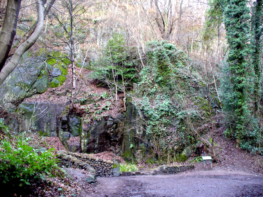
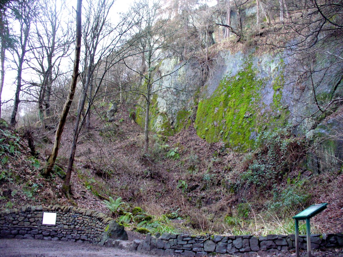
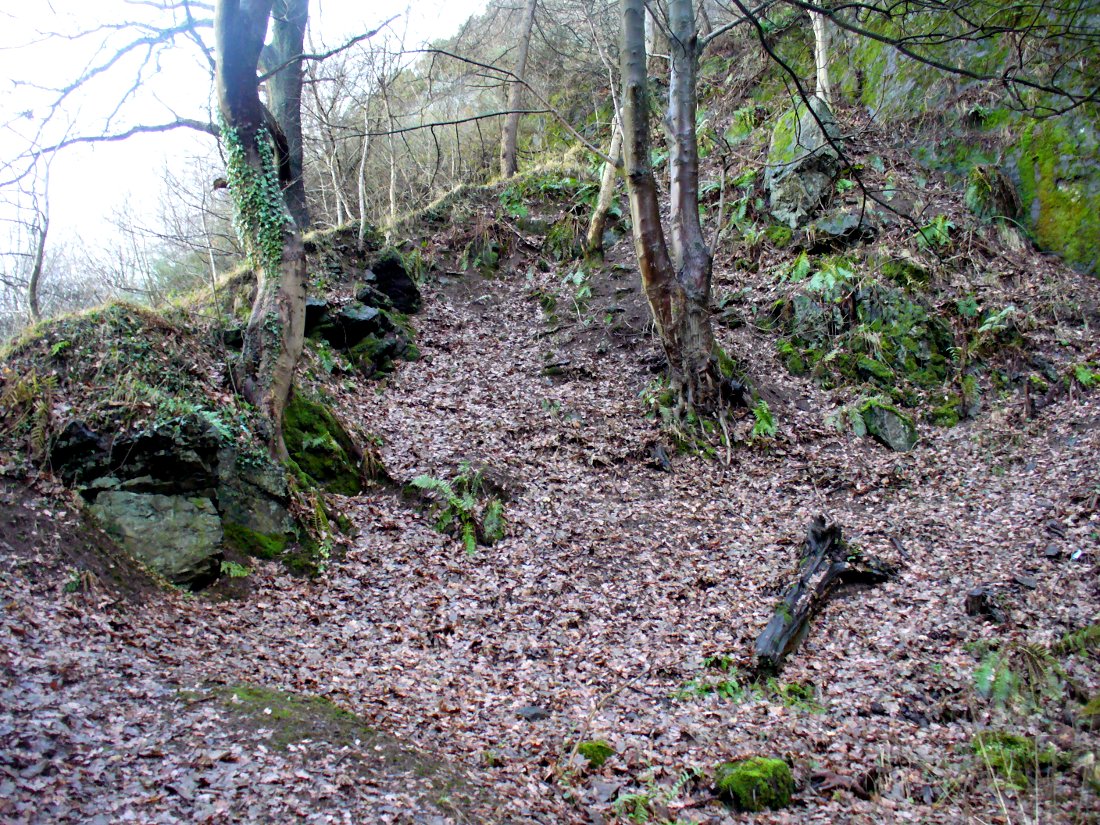
This is a truly fascinating site for a number of reasons. Sadly, we can no longer see what had been here for oh so many thousands of years thanks, as usual, to the industrialists destroying the land here. Although in this case, without them we’d be unaware of its very existence. Additionally, there is a twist to the industrial’s find, which seems to have stopped further quarrying by some local people….
The tomb was somewhere in the left-middle
Listed in the relative Royal Commission accounts (1933; 1978), without comments, the tale is a simple one, but was narrated in some detail by J.G. Callander (1914) in Scotland’s prodigious Society of Antiquaries journal. During some quarrying operations over the Christmas period of 1912, James Murdoch “uncovered the remains of a human skeleton which had been buried in a natural cavity in the rock.” Three weeks later, local police officer George Donald and Dr W.L. Cunningham of Alva, accompanied Mr Callander to the site and made a detailed assessment of what had been found. He wrote:
“The quarry in which the grave was found is situated at the mouth of Alva Glen, a few yards distant from the right bank of the burn which flows through it. The body had been placed in a cavity or rock shelter in the face of the cliff, about 40 feet from the base, and about 200 feet above sea-level, and a rough, curved wall of dry-stone building, about 1 foot in thickness, had been built across the opening, which faced the east, the ends of the wall being still in situ when I visited the site. The space enclosed measured about 4 feet 6 inches from north to south, and about 5 feet from east to west. Subsequent to the burial the whole face of the rock and the walling had been covered, to a thickness of probably some 6 feet, by soil and detritus washed down from the hill face above. The greater part of the floor of the cavity was formed of clean, broken, angular stones, but the space on which the body was placed had been covered with a thin layer of soil preparatory to the burial. No charcoal or charred wood, which is so often seen in prehistoric graves, was found in this deposit. The skull lay in the north end of the grave, on its right side, facing the rock to the west, the vertebrae and ribs followed a line to the south, and the nether limbs were inclined towards the interior of the cavity. The whole face, including all the teeth and the lower jaw, was a-wanting. Apparently the body had been placed in a flexed position, half on its side and half on its back. Nothing else was found in the grave but a quantity of snail shells, probably twenty or thirty, which were nearly all broken, the few complete examples being in a very fragile condition.
“Elsewhere it has been stated that these formed a necklace, but while they were strewn out in front of the skeleton for a distance of over 3 feet, none of them showed any signs of artificial perforation. The species of Helixis is probably hortensis, the common garden snail.”
Mr Callander then included a lengthy description of the body itself, some of whose bones were fractured. He told that a certain
“Professor Bryce states that the skeleton is that of a dwarf of about 4 feet 2 inches in stature. The epiphyses are all fully united, although the line of union is visible on the surface at some points. Growth must therefore have been completed, and the person must have been, if the union of the epiphyses of the long bones had pursued its normal course, over twenty-one years of age…”
Regarding the sex of the dwarf, Mr Bryce wasn’t 100% certain, but told:
“The calvaria shows the general characters of a female skull, but it cannot be stated definitely that the individual was a woman, because the cranial characters are such as might have been present in a dwarf of the male sex. The calvaria is of moderate size, and is well formed.”
Bryce concluded as a whole that this person was in reasonably good health and, from the condition of the bones, showed “there was no evidence of the disease known as rickets.” In his final remarks he told:
“The general conclusions to which a careful examination of the skeleton leads, is that we have here to do, not with a representative of a dwarfish race, but with an individual who from premature union of the epiphyses was to a remarkable degree stunted in growth. The condition is a well-known one, and the class of dwarfs, in which this individual must be included, is well recognised.”
Probable spot of the lost tomb
The exact spot of the tomb appears to have been destroyed, or at the very least is certainly covered over and no longer visible. The section of the quarry looking east, into which the tomb was built, is all-but gone and no initial evidence prevails to show its exact location. However, it would seem from the description to have been close to the tops of the tree-line, perhaps giving a clear view to the rising sun in the east. Perhaps…
The position of this tomb, enclosed high up in the cliffs, hidden away at the entrance to the deeply cut ravine of the Alva Glen, is intriguing in that it is a rarity. Ravines like this are always peopled by olde spirits in animistic tribal traditions — and this dangerous glen with its fast waters and high falls would have been no different, especially to the Pictish people who we know were still here even after the Romans had buggered off. Is it possible that this figure was a guardian to the Glen itself, a medicine woman or shaman, whose very Glen was her home? We know from traditional accounts in many of the North American tribes that dwarves were accessories to the spirit worlds, and some were shamans. (Park 1938) In northern and central European lore, these small people are “the mysterious craftsmen-priests of early civilizations.” (Motz 1987) Whilst in Scottish lowland lore, the ‘Brown Man of the Muirs’ was a dwarfish creature described by Briggs (1979) as “a guardian spirit of wild beasts”, or watered-down shaman figure. There is more to this burial than meets the eye of dry academia…
Folklore
The Alva Glen—in addition to being beautiful and home to the Ladies Well—was long known to be one of many places in the Ochils that were peopled by the faerie folk. (Fergusson 1912) Local people still say this place is haunted by the spirit of a dangerous witch called Jenny Mutton.
It’s worth reiterating the words of Mr Callander (1914) regarding the finding and subsequent death of the man who uncovered this fascinating tomb, as some folk (then as now) think his demise was as inevitable as the man who planned on building turbines in Glen Cailleach:
“On the 24th December last, while quarrying stone for road metal in a quarry at the foot of the Ochils, at Alva, James Murdoch uncovered the remains of a human skeleton which had been buried in a natural cavity in the rock. Two days later he was killed at the same spot by the fall of a mass of overhanging rock, a tragic sequel, which not long ago would have been considered a judgement on him for disturbing the dead.”
References:
Briggs, Katherine M., A Dictionary of Fairies, Penguin: Harmondsworth 1979.
Corbett, L., et al., The Ochil Hills, Forth Naturalist & Historian 1994.
Drummond, A.L., “The Prehistory and Prehistoric Remains of the Hillfoots and Neighbouring District”, in Transactions Stirling Natural History & Antiquarian Society, volume 59, 1937.
Fergusson, R. Menzies, The Ochil Fairy Tales, David Nutt: London 1912.
Gimbutas, Marija, “Slavic Religion,” in Encyclopedia of Religion – volume 13 (editor M. Eliade), MacMillan: New York 1987.
Motz, Lotte, “Dvergar,” in Encyclopedia of Religion – volume 4 (editor M. Eliade), MacMillan: New York 1987.
Park, Willard Z., Shamanism in Western North America: A Study in Cultural Relationships, Evanston: Chicago 1938.
Royal Commission on the Ancient & Historical Monuments, Scotland, Inventory of Monuments and Constructions in the Counties of Fife, Kinross and Clackmannan, HMSO: Edinburgh 1933.
Royal Commission on the Ancient & Historical Monuments, Scotland, The Archaeological Sites and Monuments of Clackmannan District and Falkirk District, Society of Antiquaries of Scotland 1978.
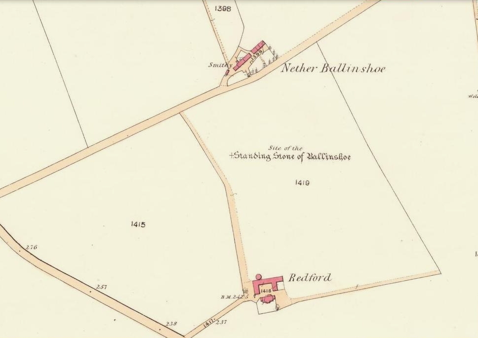
In a region that is full of prehistoric remains, we find here another example of another megalithic site that was sadly destroyed, not too long ago by the scale of things. Found in association with a large prehistoric urn, we are thankful to have a couple of early local history accounts that describe the place. The stone was obviously of some considerable height and bulk, though I can find no specific references to the dimensions of the monolith. It was described effectively in the middle-half of the 19th century by Andrew Jervise (1853), who told us:
“‘The Stannin Stane of Benshie’, which stood for unknown ages…was demolished by gunpowder about half a century ago, and the spot is now covered by luxuriant crops of corn. This rude monument of antiquity is supposed to have been about twenty tons in weight; and at a considerable depth below it, a large clay urn, measuring about three feet in height and of corresponding circumference, was found containing a quantity of human bones and ashes. Like its rude protector, however, the urn was broken to pieces; and, beyond the mere fact of its discovery, nothing authentic, as to either the style of its manufacture, or the precise nature or state of its contents, is preserved.”
More than 30 years later, A.J. Warden (1884) and then J.G. MacPherson (1885) all but copied Mr Jervise’s words, adding no further information.
From some reason, a small chapel dedicated to St. Ninian (NO 41567 51932) was built about 100 yards or so to the southwest of the old standing stone. Its ruins are still to be seen. Whether this was an attempt to divert local people away from their animistic ecocentricism at the stone, into the more ecocidal egocentricism of the incoming christian cult (as was/is their common practice), we may never know for sure.
Folklore
The local name of this stone, ‘The Stannin Stane of Benshie’, indicates simply that this was “the standing stone at the hill of the faerie folk” (or variations thereof) and suggest it stood upon or next to a mound. I can find no immediate reference to stories of the little people here, and their whisper may have faded into unconscious memory. Does anyone know more about this place?
References:
Jervise, Andrew, The History and Traditions of the Land of the Lindsays in Angus and Mearns, Sutherland and Knox: Edinburgh 1853.
MacPherson, J.G., Strathmore: Past and Present, S. Cowan: Perth 1885.
Royal Commission on the Ancient & Historical Monuments of Scotland, The Archaeological Sites and Monuments of Central Angus, Angus District, Tayside Region, Edinburgh 1983.
Warden, Alex J., Angus or Forfarshire: The Land and People – Descriptive and Historical – volume 4, Charles Alexander: Dundee 1884.