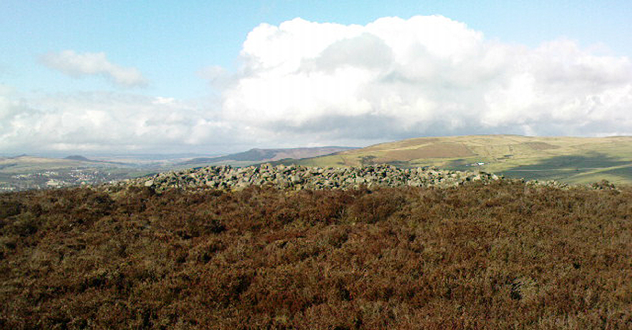
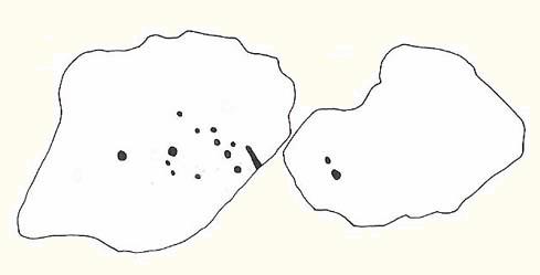
Black Hill Round Cairn, Low Bradley Moor, Skipton, North Yorkshire

Cairn:  OS Grid Reference – SE 0087 4753

Also Known as:

  1. Black Hill Cairn
  2. Bradley Moor Round Cairn
  3. Queen’s Cairn
The Black Hill Round Cairn, Bradley Moor - looking north
The Black Hill Round Cairn, Bradley Moor – looking north

Getting Here

Various ways here.  Best is probably taking the footpath onto Farnhill Moor a few hundred yards east of Kildwick Hall.  Head for the cross-bearing Jubilee Tower (supposedly built upon an ancient cairn), NW, keep going past it uphill until you reach the walling 350 yards north, where a seat let’s you have a rest.  Climb over the wall! Alternatively, walk eastwards and up through the steep but gorgeous birch-wooded slopes of Farnhill Wood; and as the moortop opens up before you, the great pile of rocks surmounts the skyline ahead. You can’t miss it! (NB: the spot cited on the OS-map as the cairn is in fact another site, 100 yards NW)

Archaeology & History

Its an awesome place in an awesome setting. You can see 360-degrees all round from this giant mass of rocks — something which was of obvious importance to the people who built it. If it had been placed 20-30 yards either side of here, that characteristic would not occur. Indeed, this is the only place anywhere on these moors where such a great view was possible. Important geomancy, as they say (or whatever modern term they give it these days).
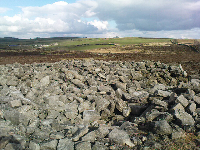
Bradley Moor Cairn - looking down to the Long Cairn
Bradley Moor Cairn – looking down to the Long Cairn
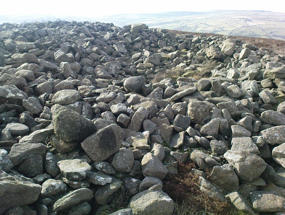
Small section of the old cairn

Although the tomb is still of considerable size (at least 100 feet across) and made up of thousands of stones, it has been severely robbed of stone in years passed, for walling and other building materials.  A number of other small cairns scatter the heathlands a few hundred yards roundabout this central giant (though are hard to find in the deep heather); and there is a distinct cairn circle about 100 yards to the northwest, which has yet to be excavated.  This cairn circle can be made out quite easily if you stand on the ridge about 30 yards west of here, looking down the slope.  An then of course we have the equally huge  Black Hill Long Cairn, less than 100 away, aligned northwest-southeast, which obviously had an important archaeological relationship with this giant round cairn.  Also around this and the adjacent long cairn, numerous flints and scrapers have been found, showing humans have been here since at least the early neolithic period.  And recently, what seems to be a fallen standing stone has been found laying in the heather, 168 yards to the north.

This site in particular gives me the distinct impression that it was the most important of the various sites upon these moors. It’s got a distinctly female flavour to it – and it’s old name of the Queen’s Cairn seems just right.  Maybe it’s the fact that when I first visited the place, a great thunderstorm broke through the previously perfect skies, scattering lightning bolts all round for perhaps thirty minutes — so I stripped myself naked and reached my arms out-stretched, cruciform, screaming to the skies in the pouring rain!  Thereafter, no clouds appeared in the skies for the rest of the day.  It was a brilliant welcome to the place!

References:

  1. Cowling, E.T., Rombald’s Way, William Walker: Otley 1946.
  2. Keighley, J.J., ‘The Prehistoric Period,’ in Faull & Moorhouse’s West Yorkshire: An Archaeological Survey, I, WYMCC: Wakefield 1981.
  3. Raistrick, Arthur, ‘Prehistoric Burials at Waddington and Bradley,’ in YAJ 119, 1936.

© Paul Bennett, The Northern Antiquarian

Long Bredy Cursus, Dorset

Cursus:  OS Grid Reference – SY 5718 9115

Also Known as:

  1. Martin’s Down Cursus

Archaeology & History

Although very little of this cursus can be discerned on the ground, the scar of the monument is clearly visible from the air (as the GoogleEarth image shows, below).  In 1989 the great archaeo-geomancer, Paul Devereux, visited the place hoping to see the monument, but said that no remains were visible at ground level, although noted how its western end is marked by the Long Bredy burial mound.  Sitting amidst a mass of later neolithic and Bronze Age ceremonial remains, this old cursus aligned SE to NW.  Devereux told how,

“the extended axis of the cursus…to the east, goes through a group of round barrows on the crest of a ridge on Black Down about a mile away. If diagrammatic material published by an investigating archaeologist is accurate, the alignment continues to the Nine Stones circle…immediately by the roadside a short distance west of Winterbourne Abbas.”

The monument has been measured at be at least 130 yards (100m) long and 28 yards in diameter at its greatest point.

References:

  1. Pennick, Nigel & Devereux, Paul, Lines on the Landscape, Robert Hale: London 1989.

© Paul Bennett, The Northern Antiquarian

Litton Cheney, Dorset

Timber Circle / Earthworks:  OS Grid Reference – SY 556 917

Getting Here

From Litton Cheney go north up the White Way road until it meets the main A35 crossroad.  Go across the road, then get over the fence on your right and onto the rise in the hill.  These earthworks, or timber circle remains, are under your feet!

Archaeology & History

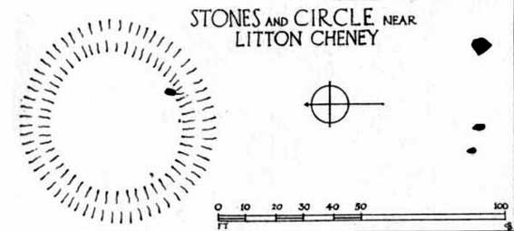
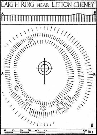
Lay-out of site by O.G.S. Crawford, 1939

Shown on modern OS-maps as an ‘earthwork’, but ascribed elsewhere as a timber circle, when Stuart & C.M. Piggott visited and surveyed this site in the 1930s, they thought it to be the remains of stone circle.  Found on a prominent rise in the landscape with excellent views all round here, the Piggott’s description of the site told:

“It consists of a shallow ditch with internal bank, enclosing a somewhat oval area measuring 75 feet from north to south, and 63 feet from east to west. The ditch, which lies on the southeast, where the ground has been disturbed, does not reach a depth of more than about one foot, while the bank rises nowhere above 2.5 feet. It is possible there was an entrance on the southeast, but the bank is disturbed at this point. On the crest of the bank on the southwest are 3 almost circular depressions, some 6 feet in diameter, and placed 20 feet distant from one another along the circumference of the bank. Another similar depression is on the northeast, while yet another may have existed in the disturbed portion of the bank on the southeast.”

It was these finds which led them to suppose a ring of stones originally surmounted this small hillock, twelve in all.

Lay-out of the circular remains, by O.G.S. Crawford
Ground-plan by O.G.S. Crawford

Another site — which they called ‘Litton Cheney 2’ — was found less than 50 yards to the east of here by a Mr W.E.V. Young and the Piggotts.  These remains comprised of, “a very shallow and regular ditch surrounding a circular area 47 feet in diameter.  A single sarsen lies on the inner lip of the ditch on the southeast” which, they thought, may have been the solitary remains of yet another stone circle. Three other sarsen stones were found 90 feet south of here, but they were unsure whether they related to the circle or not.

Archaeological remains from here dated from 2200-1400 BC and local researcher Peter Knight (1996) thought that the sites ascribed here as megalithic rings to be correct.  He also found that tumuli visible some 5 or 6 miles southeast of here, on top of Black Down Hill (where the Hardy Monument’s found), “marks out the winter solstice sunrise.”  A dip in the horizon to the northwest, he claims, also marks the summer solstice sunset from here.  Knight also mentions how “both Litton Cheney sites lie close to a ley line going to the Nine Stone Circle and beyond.”

References:

  1. Knight, Peter, Ancient Stones of Dorset, Power: Ferndown 1996.
  2. Piggott, Stuart & C.M., ‘Stone and Earth Circles in Dorset,’ in Antiquity, June 1939.

© Paul Bennett, The Northern Antiquarian

Lechlade Cursus, Gloucestershire

Cursus:  OS Grid Reference – SP 2125 0046

Archaeology & History

In Pennick & Devereux’s (1989) early assessment of our enigmatic cursus monuments, he wrote the following brief notes of this particular site:

“The crop marks of another fragmentary cursus were found in Gloucestershire immediately north of Lechlade, to the west of the River Leach. The crop marks aligned northwest-southeast for 174 yards (160 metres) and were 160 feet (50 metres) wide. Only the square northwest end is known. Excavations were carried out in 1965 in advance of gravel workings. No finds were reported, but two out of three cuttings revealed a post-hole on the inside of the ditch.”

References:

  1. Pennick, Nigel & Devereux, Paul, Lines on the Landscape, Hale: London 1989.

© Paul Bennett, The Northern Antiquarian


Langbar Stone, Langbar Moor, North Yorkshire

Cup-and-Ring Stone:  OS Grid Reference – SE 11180 52052

Also Known as:

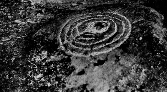
  1. Carving no.41 (Feather)
  2. Carving no.459 (Boughey & Vickerman)

Getting Here

Langbar Moor carving - with extra ring
Langbar Moor carving © Richard Stroud

Various ways to get here (being in the middle of the moor n’ all).  I s’ppose the best way is to go from Langbar village, up hill to The Old Pike giant cairn, then follow the footpath on about 100 yards before dropping down the slope to your right, south (NOT the other way!).  You’ll notice some walling and an old path near the bottom of the slope SE from you – head in that direction, but before you get there, a coupla hundred yards before, stop and look around.  Good luck!

Archaeology & History

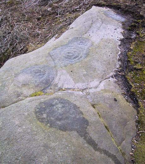
Found halfway up the southern slope beneath The Old Pike giant cairn, we find this large, flat earthfast stone, on which are the very faded remains of archetypal cup-and-ring motifs. At the top-end of the stone are slightly more pronounced cup-markings – seemingly more than is shown on the drawing, with the multiple-rings halfway along the stone. On the southeastern part of the stone, Richard Stroud found another previously unseen aspect of the carving, consisting of one large ring, with perhaps a line running out to the east. This can be seen in the water-highlighted photo.

Langbar Stone, with small single circle not noticed by archaeologists
Langbar Stone, with extra single ring not previously noted

If you visit this carving, try and get to the Middleton Moor CR-482 stone half-a-mile southwest – where I for one got the distinct impression that whoever carved that stone, also carved this one!  Barmy p’raps — but if we don’t allow subjective interface here and there, we never learn a damn thing!

Listed as stone 459 in Boughey & Vickerman’s (2003) survey, they erroneously ascribe Eric Cowling to have found it in Rombald’s Way (1946), whereas the first mention of it appears to have been by Stuart Feather in 1966 (though Cowling does mention a ‘Langbar Stone’, but illustrates another one nearby).

References:

  1. Boughey, Keith & Vickerman, E.A., Prehistoric Rock Art of the West Riding, WYAS 2003.
  2. Cowling, Eric T., Rombald’s Way, William Walker: Otley 1946.
  3. Feather, Stuart, ‘Mid-Wharfedale Cup-and-Ring Markings. No.41, Langbar Moor, Ilkley,’ in Bradford Cartwright Hall Archaeology Group Bulletin, 11, 1966.

© Paul Bennett, The Northern Antiquarian

Knotties Stone, Otley Chevin, West Yorkshire

Cup-and-Ring Stone:  OS Grid Reference – SE 20772 44181

Also Known as:

  1. Carving no. 396 (Boughey & Vickerman)

Getting Here

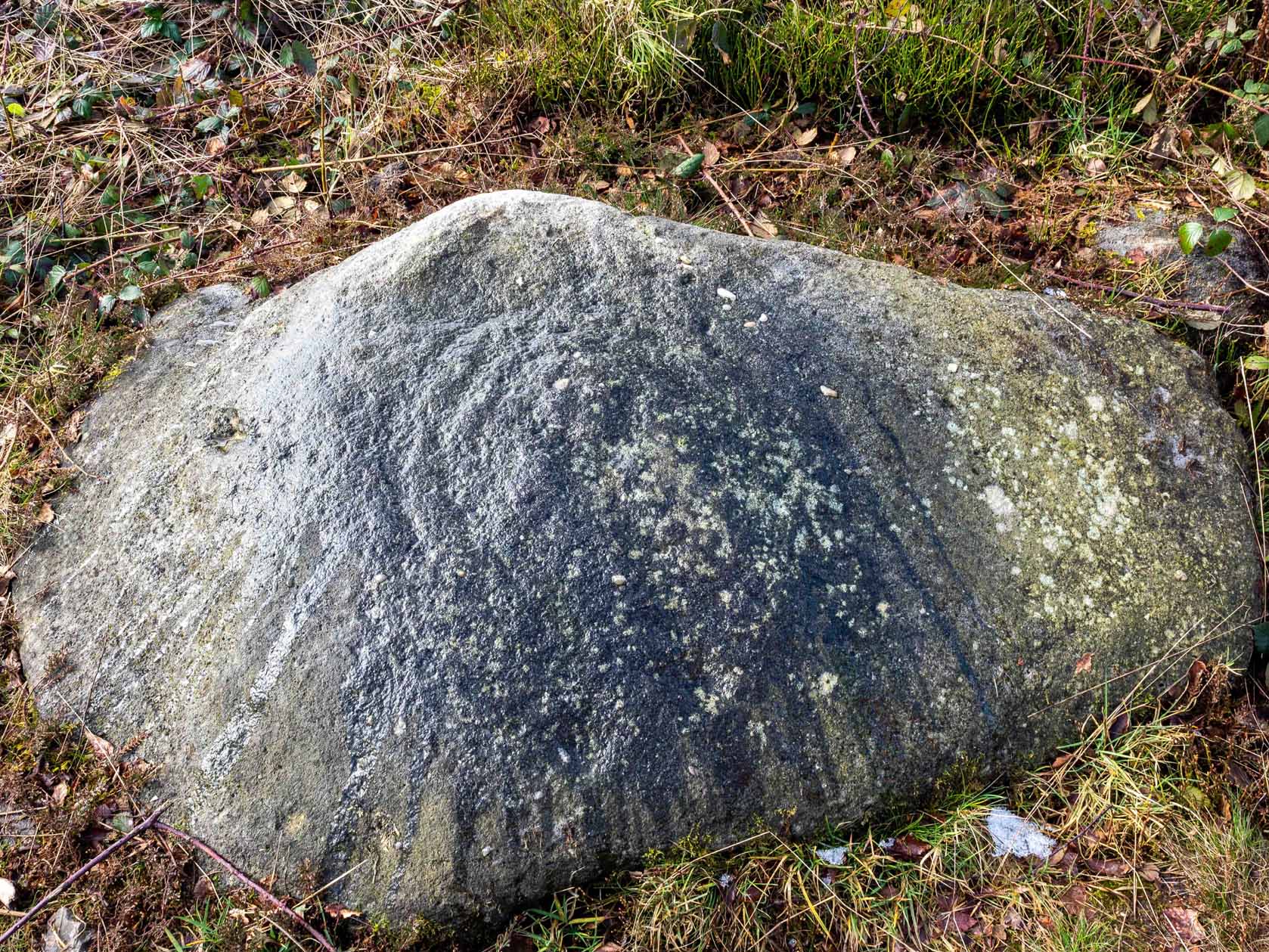
Knotties stone (photo, James Elkington)

From The Royalty hotel, walk along the footpath onto the Chevin itself, turning left then walk about 350 yards east, past the small copse of trees.  Just north of the main path before the land slopes down you’ll find it.  It’s carved on an earthfast rock about 6 feet long.

Archaeology & History

This is an excellent carving if you’re into cup-and-rings!  Eric Cowling (1940) first described the stone* in an article for the Yorkshire Archaeology Society.  Although it’s somewhat faded, when the stone’s wet and the sun’s low on the horizon, you can make out more rings than just the three which Boughey & Vickerman (2003) described in their survey.

Folklore

Knotties Stone (E.T. Cowling)

Although the Chevin itself has a tradition of ‘supposed’ heathen goings-on in bygone days, the carving has nothing specific said about it.  Although one intriguing bit of info comes from the old Otley historian, Harold Walker (1974), who said that, “blocks of stone were sent from (the) Chevin to form the foundations of the Houses of Parliament”!

Those lying deviants probably smashed up a few bits of extra rock art when they did this — not that those sort of people give a shit about anything unless it’s about money.

References:

  1. Boughey, Keith & Vickerman, E.A., Prehistoric Rock Art of the West Riding, WYAS 2003.
  2. Cowling, E.T., ‘A Classification of West Yorkshire “Cup-and-Ring” Stones,’ in Archaeology Journal, 97, 1940.
  3. Cowling, E.T., Rombald’s Way, William Walker: Otley 1946.
  4. Hotham, John Paul, Halos and Horizons, Hotham Publishing: Leeds 2021.
  5. Walker, Harold, This Little Town of Otley, Olicana: Otley 1974.

* Graeme Chappell tells me that this carving was named after Cowling’s nickname, Knotty!

© Paul Bennett, The Northern Antiquarian 

Kilninver, Oban, Argyll

Standing Stone (destroyed):  OS Grid Reference – NM 8250 2207

Also Known as:

  1. Canmore ID 22969

Archaeology & History

Marked on the earliest 6-inch Ordnance Survey map of this area (1875), this 4ft tall standing stone (now gone) once stood on the east bank of the River Euchar. The prehistoric cairn 400 yards to the west on the other side of the river would seem to have had some relationship with the stone, as they aligned to the equinoxes.

References:

  1. Royal Commission on the Ancient & Historical Monuments of Scotland, Argyll – volume 2: Lorn, HMSO: Edinburgh 1974.

© Paul Bennett, The Northern Antiquarian


Keill Vreeshey, Crosby, Isle of Man

Standing Stone:  OS Grid Reference – SC 3316 8014

Archaeology & History

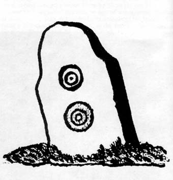
Keeill Carved Stone (Shaw 1877)

Seemingly destroyed, this carved standing stone was first described in Shaw’s Tourist Guide to the Isle of Man (1877), where he says it stood by the wall of the chapel, telling how it was “one of several stones inscribed with various designs and inscriptions.”

Hope that I’m wrong, but it seems like we’ve lost some more good old cup-and-ring art…

References:

  1. Shaw, N., Tourist Guide to the Isle of Man, 1877.

© Paul Bennett, The Northern Antiquarian

High Street Barrow, Towthorpe, East Yorkshire

Tumulus:  OS Grid Reference – SE 881 637

Also Known as:

  1. Towthorpe Barrow 1

Getting Here

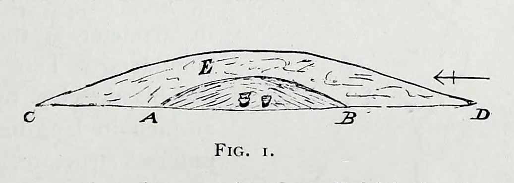
Mortimer’s sketch of Towthorpe-1 barrow

The faded remains of this old burial mound can vaguely be seen just off the right-hand (east) side of the B1248, across the road from the track which leads down to Burdale North Wold farmhouse, between Fimber and Wharram-le-Street.

Archaeology & History

Known as Towthorpe Barrow No.1 in the Mortimer survey (1905), there are a number of prehistoric tombs and other remains close to this site (which will be described on TNA as time goes by).  Some of you might think the lengthy description here a little unworthy, but I believe the extensive archaeological notes on this site by an archaeological legend, J.R. Mortimer, is a good indicator of the dedication and interest to which he gave each and every tomb that he opened (this’ll be the first of many). His slightly edited account told:

“This mound is situated near the centre of the (Towthorpe) group, close to High Towthorpe. Here the green lane…is crossed by the high road from Malton (B1248), through Wharram-le-Street… Part of this road, for some distance south and north of the barrow, is called ‘High Street’ by the old inhabitants of the neighbourhood…

“On 4 May, 1863, the writer, with the assistance of R. Mortimer and two workmen, commenced to open this mound. It was the first British barrow he had the pleasure of examining. A trench 10 feet wide was cut across its centre from the northern to the southern margin…

“The upper portion E, to a depth of 16 inches, consisted chiefly of the surface soil of the neighbourhood, the bottom part of which was reddened as if by the action of fire. Close below this was a stratum of wood and ashes and other dark matter, 2-3 inches in thickness; and then a lenticular bed of tough drab-coloured clay, 29 feet in diameter, and 12-14 inches thick in the centre, gradually thinning towards the circumference. The upper part of this bed of clay, which was in contact with the stratum of wood ashes, was reddened by fire; its under surface had a similar appearance and rested upon what seemed to be a second stratum of burnt and decayed matter, 2-3 inches in thickness, similar to that already described. The clay forming this lenticular bed contained numerous small fragments of grey flint, characteristic of the chalk of the neighbourhood. It must have been obtained from one of the valley bottoms (either Burdale, Wharram-le-Street or Duggleby), in which are exposures of the Kimeridge clay. In these places, angular pieces of flint and chalk crumble from the hillside, and mix with the clay, imparting a greyish colour to it. This is especially the case at Burdale, where there is a fine spring at the base of the chalk, and a small pond resting on the Kimeridge; and it is probably from this place that most of the clay for the construction of this barrow was obtained. It is not easy to explain the method by which the clay was transported, but several tons had evidently been used in this case. Many other instances in which material from a distance has been used in the erection of the barrows of this neighbourhood are recorded in (the Yorkshire Wolds).

“In the centre of the mound, at the base of the lenticular bed of clay and below the ashes (which probably represent the residue of a funeral pyre) stood two food vases, close together, and near to these, decayed bones (the remains of a human body) and a chipped flint. The smaller and more ornamented vase was situated to the south of its fellow. It measures 4.5 inches in neight, 5.5. inches in diameter at the top, and about the same across the shoulders. The ornamentation had been impressed on the plastic clay by a thin square-ended tool, about half-an-inch in length, which showed in the impression of a fine notched structure, and was equally divided into ten ridges about the size of the indentations on the milled edge of a shilling, and almost as truly cut. In the lower groove which runs round the vase are four pierced projections.

“The other vase is about 5 inches high and about 6 inches in diameter at the top and across the shoulders. Three encircling lines of short vertical cuts, rudely and apparently hastily made, previous to baking the vase, represent its entire ornamentation.

“During the excavation we collected from the material of the mound a dozen hand-struck flint flakes of various sizes, and a small splinter from the cutting-edge of a green-stone celt.”

Mr Mortimer returned to do further excavations here on Christmas Eve and Christmas Day in 1865, with the hope of finding more — but apart from a finely-cut knife made of black flint, nothing else was located. This was the first of Mortimer’s hundreds of diggings into the tombs and dykes of East and North Yorkshire.

References:

  1. Marsden, Barry M., The Early Barrow Diggers, Tempus: Stroud 1999.
  2. Mortimer, J.R., Forty Years Researches in British and Saxon Burial Mounds of East Yorkshire, A. Brown: London 1905.

© Paul Bennett, The Northern Antiquarian

High Carr Rocks, Keighley, West Yorkshire

Cup-and-Ring Stones:  OS Grid Reference – SE 0578 4395

Getting Here

High Carr Cup-Markings (1 & 2)

Loadsa ways to get to this little outcrop, which the Boughey & Vickerman survey (2003) says comprises of five different carvings (CRs 33-37).  I’m not so sure misself.  When Stuart Feather first found these in the 1950s, he only thought three stones were carved, which I think is the more accurate.

Most folk would probably prefer to walk down the slope from Holden Gate down the footpath past Jaytail Farm, then dropping down to the very bottom of the fields (south) where you’ll see a small knoll with a cluster of rocks just in front of the tree-line.  But I wandered up thru the ‘Private’ (ahem!) woodland, wet-thru in the pouring rain, and clambered over the wall right to the very spot (the old dowser’s ‘seek-and-find-rock-art’ nose worked again!).

Archaeology & History

High Carr Cup-Marked Stone
High Carr Cup-Marked Stone – from Hedge’s Carved Rocks on Rombald’s Moor

Listed in John Hedge’s (1986) survey as carvings 1-5, I’d say there’s one “definite” carving here, but the others – comprising simply of cups – are a little dubious.  The main carving has at least six definite cup-markings, found on the rock at the highest point of the knoll at the bottom of the field.  The drawing in Hedge’s survey shows as many as 12 cups on this stone, but I’m not totally convinced.  Another stone right next to the main one has, perhaps, a cup-marking or two on it – but again, these may be natural.

Of the other alleged carvings, it was difficult to work out as they were literally covered in tons of cow-shit. It seems this rock-outcrop is the local bovine toilet!  A lovely secluded place though, with plenty of wildlife to see.  Next stop from here: the great Holden waterfalls!

References:

  1. Boughey, K. & Vickerman, E.A., Prehistoric Rock Art of the West Riding, WYMCC: Wakefield 2003.
  2. Feather, S., ‘Three Bronze Age Rock Carvings near Keighley,’ in CHAGB 4:3, 1959.
  3. Hedges, John D., The Carved Rocks on Rombald’s Moor, WYMCC: Wakefield 1986.

© Paul Bennett, The Northern Antiquarian