Dun Chathach, Connel, Argyll

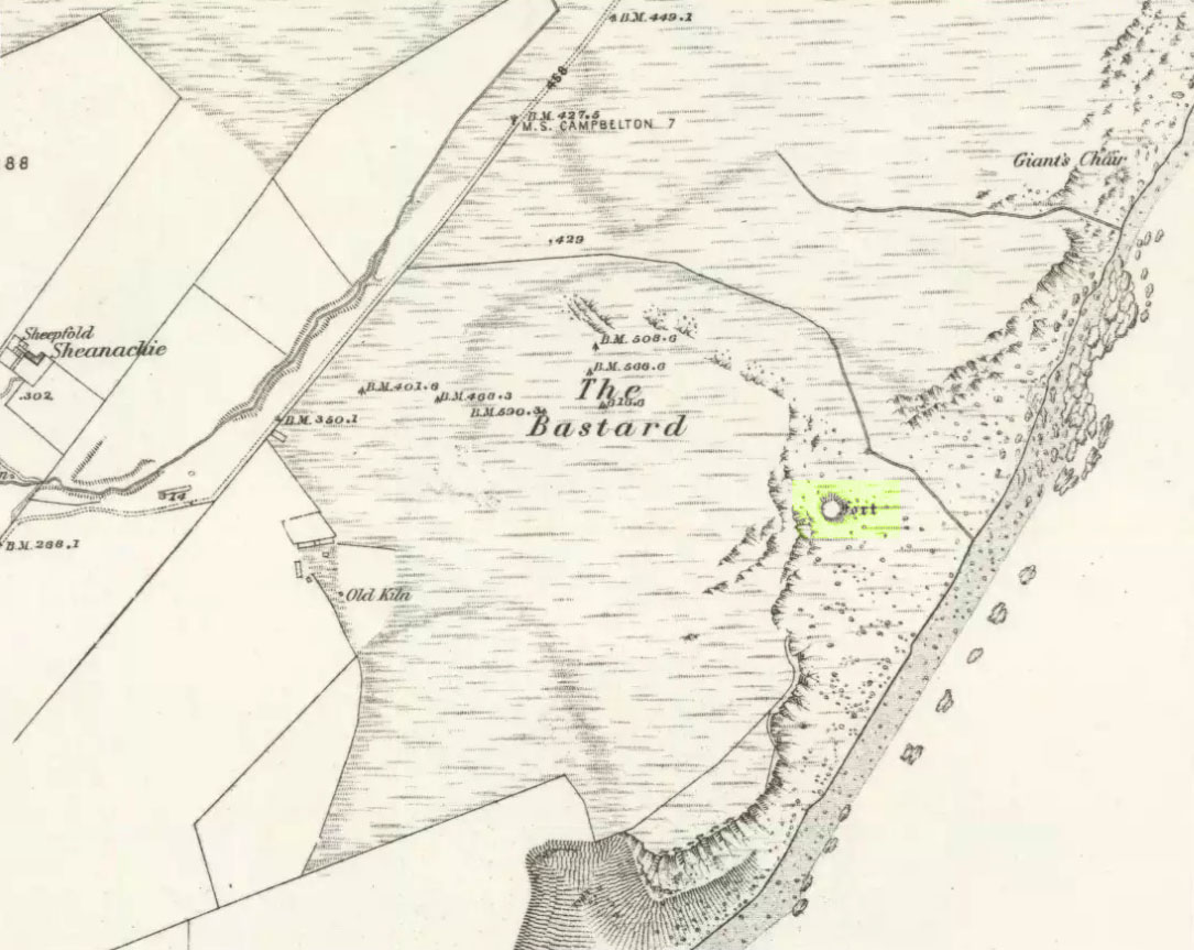
Hillfort: OS Grid Reference – NM 9674 3401

Also known as:

  1. Canmore ID 23261
  2. Dun Cathich

Getting Here

Dun Chathach (drawn by Miss J. Knox Smith 1885)

Go up from Oban on the A85, past Connel and towards Taynuilt, keeping your eye out for where the train-line crosses the road. Just before this is a small road on your left leading down to the sea, with the train line running parallel all the way down. Go right to the end and then look up to the rocky rise a coupla hundred yards on where the train line runs out of view round the coastal edge. That’s it!

Archaeology & History

When Scottish writer and historian R. Angus Smith (1885) first saw this, the close arrangement and size of the stones that make up the edges of this dun made him think this was actually a stone circle up here.  Sadly it wasn’t to be.  Following an examination of the site in 1969 by members of the Scottish Royal Commission (Argyll – Volume 2, 1975), they described Dun Chathach as,

“circular in plan…measuring 18.3 metres in diameter externally. The wall, which has been about 3.4 metres in average thickness, is now reduced to a low grass-grown stony bank, but considerable stretches of the outer face are still visible in situ. Many of the facing stones, which lie as much as 1.6 metres below the level of the summit, are of massive proportions, the largest measuring 1.4 metres by 1.3 metres and 1 metre high. It is uncertain which of the three gaps now visible in the wall indicates the site of the original entrance.”

Folklore

Legend has it that this was a hill of battles.  It was also said by R. Angus Smith (1885) to “have been used as one of a chain of beacons,” with the next fire on being lit upon a small hill nearer Connel called Tom na h-aire, ‘the mound of watching.’

References:

  1. Royal Commission on the Ancient & Historical Monuments, Scotland, Argyll- volume 2, HMSO: 1974.
  2. Smith, R. Angus, Loch Etive and the Sons of Uisnach, Alexander Gardner: London & Paisley 1885.

© Paul Bennett, The Northern Antiquarian

Carlowrie, Kirkliston, Midlothian

Cup-and-Ring Stone (destroyed):  OS Grid Reference – NT 138 746

Archaeology & History

Lost carving of Carlowrie

Two-thirds of a mile west of the Cat Stane, on land immediately north of the River Almond by Edinburgh Airport in an area that was reported in 1780 to be “filled with the skeletons of human bodies,” this old petroglyph could once be found.  The Scottish Royal Commission (1929) described it as being a covering stone for a short prehistoric tomb near the OS-grid reference cited here, “but when discovered it was much broken by the plough that it does not appear to have been preserved.”  They refer instead to the last report of the site in the Scottish Society of Antiquaries journal, where we were informed that the cover stone was,

“marked with three series at least of concentric circles… The widest diameters of the sets of rings cut on the inside of the lid is about five inches, and each set is composed of five concentric circles.”

All trace of this carving appears to have been lost.  Other carvings reported nearby in the 19th century also appear to have been lost or destroyed.

References:

  1. Morris, Ronald W.B., The Prehistoric Rock Art of Southern Scotland, BAR 86: Oxford 1981.
  2. Royal Commission on Ancient & Historical Monuments, Scotland, Midlothian and Westlothian, HMSO: Edinburgh 1929.
  3. Simpson, J.Y., The Cat-Stane, Edinburghshire, Neill & Co: Edinburgh 1862.
  4. Simpson, J.Y., “On Ancient Sculpturings of Cups and Concentric Rings,” in Proceedings of the Society of Antiquaries, Scotland, volume 6, 1864-66.

© Paul Bennett, The Northern Antiquarian


Lesser Cursus, Larkhill, Wiltshire

Cursus Monument:  OS Grid Reference – SU 1056 4350

Also Known as:

  1. Small Cursus
  2. Stonehenge Smaller Cursus

Archaeology & History

James Fergusson’s drawing of both cursus monuments

Just like its much larger companion, the Stonehenge Cursus earthwork a short distance to the south, this Lesser or Small Cursus is generally deemed by archaeologists to “speak of a clear religious or ritual aspect to this patch of downland that…reaches back generations before the first Stonehenge was built.” (Pitts 2001)  The monument was aligned roughly east-west, showing possible relationships with the rising and setting of both sun and moon. (though I wouldn’t get too carried away with that misself…)

When Fergusson (1872) described this and its larger cursus companion a few hundred yards away, he thought they may have been dug to mark out lines of battle in prehistoric times, denouncing the horse-racing course hypothesis that was still in vogue at the time.  His theory drew evidence from the numerous prehistoric tombs scattering this area of Salisbury Plain, but seemed more influenced by notions of prehistoric barbarism and warfare than ideas relating to a cult of the dead — which was yet to reach it heights in the archaeological minds of Victorian England.  But, like other cursus monuments all over the British Isles, this one also seemed to have a distinct relationship with monuments of the dead: for at its western extremity (until being ploughed out of existence) was a large round barrow, catalogued as the “Winterbourne 35” tomb.  Tim Darvill (2006) tells its wider tale:

“Levelled by ploughing between 1934 and 1954, the Lesser Cursus was investigated in 1983 as part of the Stonehenge Environs Project… Three trenches were cut into different parts of this large monument, showing that there were at least two main phases to its construction.  Phase 1 comprised a slightly trapezoidal enclosure 200m by 60m, whose ditch may have been recut more than once and in part at least deliberately back-filled.  In Phase 2 this early enclosure was remodelled by elongating the whole structure eastwards by another 200m.  This extension comprised only two parallel side ditches, making the whole thing about 400m long with a rectilinear enclosure at the west end with entrances in its northeast and southeast corners giving access into a second rectilinear space, in this case open to the east.”

Lesser Cursus aerial view
Ground-plan of the Lesser Cursus (after Richards 1990)

The entire structure had finds dating from the periods between 3650-2900 BC; and the aerial imagery showing an oval-shaped structure near the eastern end was confirmed by geophysical surveys — though precisely what this is has yet to be ascertained.

It seems likely that this and other cursus monuments were, to a very great degree, not only related to mortuary practices but — as their development occurred at the same time as the destruction of Britain’s great forests began — to be monuments to the gods themselves.  This seems very evident at a couple of cursus monuments where animal deposits were made in some of the great mounds at their terminii, where archaeologists had previously assumed— incorrectly — the mounds to have been human burial mounds.  More about this in due course…

References:

  1. Darvill, Tim, Stonehenge: The Biography of a Landscape, Tempus: Stroud 2006.
  2. Devereux, Paul, The Haunted Land, Piatkus: London 2001.
  3. Fergusson, James, Rude Stone Monuments in all Countries, John Murray: London 1872.
  4. Loveday, Roy, Inscribed Across the Landscape, Tempus: Stroud 2006.
  5. North, John, Stonehenge, Harper-Collins: London 1997.
  6. Pitts, Mike, Hengeworld, Arrow: London 2001.
  7. Richards, Julian, The Stonehenge Environs Project, English Heritage: London 1990.

© Paul Bennett, The Northern Antiquarian


Raven’s Stone, Elgol, Strathaird, Skye

Standing Stone (destroyed):  OS Grid Reference – NG 520 144

Folklore

This once-famous standing stone appears to have gone.  It was described in Otta Swire’s (1961:230) superb book on the folklore of Skye, where she wrote:

“Overlooking Elgol is Bidein an Fhithich. Near here once stood the famous Raven’s Stone, about which the Brahn Seer prophesied. It is believed that this prophecy, however, can never be fulfilled, as seventy or eighty years ago the stone was broken up and the main portion of it is now incorporated in one wall of the Glendale church, according to the Rev. A. R. Forbes’ Place Names of Skye. The stone was believed to have had some connexion with old pagan religious ceremonies.”

The Brahn Seer (more commonly known as the Brahan Seer) was Coinneach Odhar, a 16th century prophet who is said to have foretold the Battle of Culloden and other events.

References:

Swire, Otta F., Skye: The Island and its Legends, Blackie & Sons: Glasgow 1961.

© Paul Bennett, The Northern Antiquarian

Kilmarie, Kirkibost, Strathaird, Skye

Stone Circle (destroyed):  OS Grid Reference – NG 552  172

Also Known as:

  1. Cille Mhaire

Folklore

Omitted from Burl’s (2000) magnum opus, the great Scottish folklorists Otta Swire (1961) is the singular reference to the forgotten stone circle that once existed here.  She wrote:

“The site of the old church of Kilmarie and of the stone circle whose proximity no doubt originally called it into being are now no longer to be seen. The ruins of the old church, I am told, were swept away by the sea during that great storm in the 1920s which also blew down the Dunvegan woods.  The storm followed not long after the burial near the old church of an unknown sailor taken from the sea, and there were those who believed this to be the cause of the church’s disappearance, for, as the old Gaelic rhyme says: “The sea will search the four russet divisions of the universe to find her children,” and Kenneth MacLeod advises that a body taken from the sea should always be buried near the water’s edge, or the sea, desiring to recover her own, will flood much land in search of it.

“This church is said to have stood on the site of an older church of St. Maelrhuba (Servant of Peace) who was the patron saint of south-eastern Skye.”

References:

  1. Burl, Aubrey, The Stone Circles of Britain, Ireland and Brittany, Yale University Press 2000.
  2. Swire, Otta F., Skye: The Island and its Legends, Blackie & Son: Glasgow 1961.

© Paul Bennett, The Northern Antiquarian 

Bel Stane, Causewayhead, Stirling, Stirlingshire

Standing Stone (destroyed?):  OS Grid Reference – NS 805 958

Archaeology & History

Nearly a hundred years ago Christina Buchan told the local writer Donald Morris (1935) about this seemingly forgotten and lost megalithic site.  The narrative she gave told:

“I remember a stone which was known among the Causewayhead people as the Bel Stane. (The name is significant)  It originally stood in the Doocot Park on Spittal Farm.  This park overlooks the high road from Causewayhead to Bridge of Allan and adjoins the steading of Spittal… When the road leading up through the village of Causewayhead was formed (about 1820), the garden of William Robb’s cottage near the foot of the Broad Loan was somewhat altered in shape.  He put up a new gate and, requiring a gatepost, he lifted the Bel Stane from Doocot Park and set it up at the front of his own house to support the gate.  It was a stone of pillar-shape and stood four or five feet above the ground, and I do not remember whether they were any markings on it.  The cottage became ruinous many years ago and the garden ran waste.  A new house is now built on the site, but the Bel Stane has been lost.”

There is a possible contender for the lost Bel Stane, used again as another gatepost, on the south-side of the road some 450 yards to the east (at NS 80922 95931).  The stone in question is somewhat fatter than usual gateposts, about four-feet tall, and has the eroded appearance of considerably greater age than many others.  The monolith isn’t mentioned in the Royal Commission’s Stirlingshire inventory. Further information would be very welcome.

References:

  1. Morris, David, B., ‘Causewayhead a Hundred Years Ago’, in Transactions of the Stirling Natural History and Archaeological Society, 1935.

© Paul Bennett, The Northern Antiquarian


Pathfoot Stone, Airthrey, Stirling, Stirlingshire

Standing Stone:  OS Grid Reference – NS 80604 96871

Also Known as:

  1. Airthrey Castle West
  2. Canmore ID 47166

Getting Here

Not too troublesome to locate really… It’s at the top-end of the University, just above the side of the small Hermitage Road, about 100 yards along.  Keep your eyes peeled to your left!

Archaeology & History

Pathfoot Stone

Today standing proud and upright, this ruinous standing stone has been knocked about in the last couple of hundred years.   Although we can clearly see that it’s been “fixed” in its present condition, standing more than 10 feet high, when the Royal Commission lads came here in August 1952 (as they reported in their utterly spiffing Stirlingshire (1963) inventory), it wasn’t quite as healthy back.  They reported:

“Many years ago the stone, which is of dark grey dolerite, fell down and was broken, and the basal portion, now re-erected, is only 3ft 10in high; two large fragments however, still lie beside the base, and the original stone is said to have stood to a height of 9ft 4in.  Of a more or less oblong section throughout, the re-erected stones measures 2ft 10in by 1ft 10in at ground level, swells to its greatest dimensions (3ft 2 in by 1ft 9in) at a height of 1ft 4in, and diminishes at the top…”

…and again!

But the scenario got even worse, cos after the Royal Commission boys had measured it up and did their report, it was completely removed!  Thankfully, following pressure from themselves and the help of the usual locals, the stone was stood back upright in the position we can see it today.  And — fingers crossed — long may it stay here!

Folklore

Commemorative plaque!

A plaque that accompanies the monolith tells that the old village of Pathfoot itself was actually “built around this standing stone” — which sounds more like it was the ‘centre’ or focus of the old place.  An omphalos perhaps?  The additional piece of lore described in Menzies (1905) work, that an annual cattle fair was held here,  indicates it as an ancient site of trade, as well as a possible gathering stone: folklore that we find is attributed to another standing stone nearby.

References:

  1. Fergusson, R. Menzies, Logie: A Parish History – volume 1, Alexander Gardner: Paisley 1905.
  2. Hutchinson, A.F., “The Standing Stones of Stirling District,” in The Stirling Antiquary, volume 1, 1893.
  3. Hutchinson, A.F., “The Standing Stones and other Rude Monuments of Stirling District,” in Transactions of the Stirling Natural History and Antiquarian Society, 1893.
  4. Royal Commission on the Ancient and Historical Monuments of Scotland, Stirlingshire – volume 1, HMSO: Edinburgh 1963.

© Paul Bennett, The Northern Antiquarian


Corwen Cross, Denbighshire

Cross & Cup-Marked Stone:  OS Grid Reference – SJ 0787 4340

Getting Here

Simple.  The church in the centre of the village across from the T-junction with the A5 is where it’s at!

Archaeology & History

Cross-base with cup-marks (from Owen, 1886)

At Corwen churchyard we find a number of curious old stone relics — not least of which is this seemingly 12th century christian cross, more than seven-feet tall, on the west side of the church. Not only does this have a curious history in itself, but the base on which the cross stands has what may be at least seven cup-markings etched on it.  These were first mentioned – I think – by Elias Owen in his Old Stone Crosses of the Vale of Clwyd, (1886) who wrote:

“The stone basement in which the (cross) shaft is placed is elliptical in form, with transverse and conjugate diameters measuring respectively 64 and 60 inches; it is 12 inches or so thick, is of a slaty nature and might have been procured in the neighbourhood… There are seven peculiar artificial depressions along the surface of the pedestal, strongly resembling the cup-markings which are found occasionally on the capstones of cromlechs, etc. They are irregularly arranged: on the north side there are three, almost in a line; and on other parts of the stone there are four of these marks. They differ somewhat from each other in size and shape, but they are for the most part circular, though one is more of an oblong than a circle. They vary also in depth, one being two-and-half inches deep, while the others are shallow. The largest is three inches in diameter; the others are not so broad.”

Owen makes note of a previous description of the Corwen “cross” by Thomas Pennant in 1784, where sounds as if this stone had a decidedly megalithic precursor. He told us:

“A most singular cross in the churchyard merits attention: the shaft is let into a flat stone, and that again is supported by four or five rude stones, as if the whole had been formed in imitation of, and in veneration of, the sacred Cromlech of very early times.”

Two other crosses are found at Corwen church – one of which has a decidely heathen legend attached to it. The Carreg y Big yn y Fach Rhewllyd monolith is also found here, in the porch wall.  A few miles east of here we also find another cup-marked stone, shown on The Old-Fashioned Antiquarian website.  Looks a good n’!

References:

  1. Owen, Elias, Old Stone Crosses of the Vale of Clwyd and Neighbouring Parishes, Bernard Quaritch: London & Oswestry 1886.

© Paul Bennett, The Northern Antiquarian


Studfold Ring, Ampleforth, North Yorkshire

Enclosure / Settlement:  OS Grid Reference — SE 58122 79855

Also Known as:

  1. Studford Ring

Getting Here

Studfold Ring from above

Pretty easy to find.  From Ampleforth town centre, go left at the T-junction and 100 yards on a footpath takes you up into the sloping fields above the town. Follow the footpath up (avoiding the fall into the small wooded valley on your left) and keep going across the fields. Follow the path towards the point of the woodland on the level, then walk along its edge until you see a rounded copse of trees on your left, with a surrounding ditch. You’ve found it! (if you hit the road, turn back & walk 100 yards)

Archaeology & History

Thought to have been first constructed in the late Bronze Age period, in 1963 R.H. Hayes described this site as being “the finest enclosure type of earthwork in the district,” telling:

“It is roughly quadrangular, some 54 yards across, rampart to rampart, with internal ditch 12ft wide and in places still 4ft in depth. The rampart is 24-26ft wide and 9-10ft high above the bottom of the ditch. It is of earth and rubble with an entrance 9ft wide on the ESE. One gets the impression that the central area is a araised platform above the level of the surrounding moor.”

Studfold Ring on 1856 OS-map

At the time of Hayes’ description, conclusions about the purpose of this site were difficult. He drew parallels between this and two other sites in northeast Yorkshire: one on Great Ayton Moor and another near Borrowby on Newton Mulgrave Moor.

On the outside of the ‘enclosure’ he described “a curious turf (?) bank 6ft wide and 2ft high which curves around the tumuli to the northeast, following the ditch of one of them, thence to another mound 32ft in diameter north of the Ring, whence it turns due west and runs towards a dewpond in the junction of three turf walls,” finally adding, “It could be connected with ancient cultivation.”

According to Eilert Ekwall (1922), the name Studfold probably derives from,

“‘Stodfalod’, which is a common name for old Roman (or other) enclosures. The name indicates that the Anglo-Saxons often used such old enclosures for horsefolds.”

Place-name master A.H. Smith (1956) reinforces this and tells us the dates of this name are even later; describing,

stod-fald OE, ‘a stud-fold, a horse enclosure’; the word is often applied to ancient enclosures which the Anglo-Saxons used for horse-folds.”

Modern archaeo’s have added the etymologist’s notion of a ‘horse enclosure’ onto their summaries of the site in recent years.

…to be continued…

References:

  1. Ekwall, Eilert, The Place-Names of Lancashire, Manchester University Press 1922.
  2. Hayes, R.H. ‘Archaeology: Dikes and Earthworks,’ in J. McDonnell’s A History of Helmsley, Rievaulx and District, Stonegate Press: York 1963.
  3. Smith, A.H. English Place-Name Elements, II, Cambridge University Press 1956.
  4. White, Stanhope, The North York Moors: An Introduction, Dalesman: Clapham 1979.

Acknowledgements:  Huge thanks to Martin Dawes for correcting my initial erroneous route to the site.

© Paul Bennett, The Northern Antiquarian 


The Bastard, Campbeltown, Argyll

Hillfort / Dun:  OS Grid Reference – NR 7612 1220

Also Known as:

  1. Canmore ID 38722
  2. Dun Bastard

Getting Here

The Bastard on 1869 map

Pretty easy.  From Campbeltown, follow the coastal round south for about 8 miles, past the TV masts on the skyline and the hamlet of Feochaig, where you’ll see the large rounded hill on your left near the coast: that’s The Bastard!  Go onto the hill’s eastern sides and drop down the steep slope towards the large bend in the burn where its remains are on a ridge close to the cliffs overlooking the sea.  The ruins are pretty faint but if you scout around, you’ll find it.

Archaeology & History

I couldn’t believe it when I found this one – so had to get the notes to the site and add what I could find!  When the fellas from the Scottish Royal Commission checked the place in 1960, they described,

“On a narrow shelf halfway down the east flank of the hill named The Bastard there are the remains of a dun…  Oval in plan, the dun measures about 15m by 12m internally and is entered from the east, where a stretch of the outer face is visible. Here the wall is 4m thick on either side of a straight passageway, 0.9m wide, which exhibits no trace of door-checks.”

The Bastard (RCAHMS 1971)

There are other remains a few yards to the southeast of the main structure which are thought to be “remains of an outer wall…about 1.2m in thickness, which has been drawn across the shelf to provide additional protection for the entrance”, more probably from the weather conditions than invasive incoming humans.

To the immediate north we have a mythic-sounding Giant’s Seat (just above the natural arch) and west is the abode of the fairy folk – but I aint checked out the tales behind them yet.

References:

  1. Royal Commission Ancient & Historic Monuments, Scotland, Argyll – Volume 1: Kintyre, HMSO 1971.

© Paul Bennett, The Northern Antiquarian