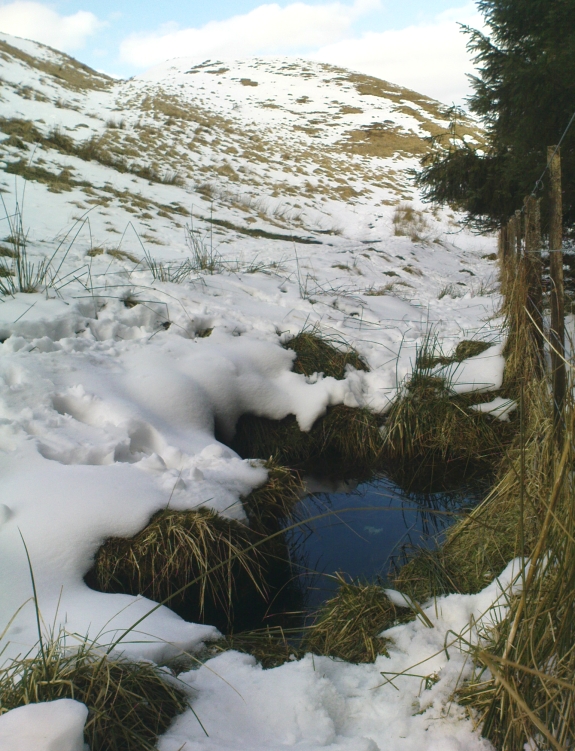
Follow the same directions as if you’re going to the Maiden Castle fairy hill. About 100 yards before reaching the hill, on the right-hand side of the footpath between the tree-line and the small stream, you’ll see a small pool of water. That is the Maiden’s Well.
Archaeology & History
Maiden’s Well & the fairy haunt of Maiden Castle hill behind
A mile northeast of the faerie-haunted Butter Well, just on the border of Clackmannanshire and Perthshire, we find this little-known magickal spring. More than a century ago, the story of this remote well was heard about hundreds of miles away by one Rev. Andrew Clark of Oxford, “who heard it from the late sexton of the parish of Dollar, in the county of Clackmannan” and who then mentioned its existence to the great Victorian Celtic scholar John Rhys (1901), who subsequently wrote of it as being “a fine spring bordered with flat stones, in the middle of a neat, turfy spot”, close to the legendary faerie hall of Maiden Castle. The well itself has now given birth to a pool whose waters, so folklore and text ascribe, always provides good clear water even in the height of summer.
The local historian Hugh Haliburton (1905) told that the well obtained its name from a princess who was held captive in Castle Campbell in the valley to the southwest, and that she was sometimes allowed out of prison by her captors, to walk to the well and drink its waters.
Folklore
This tale has been mentioned by various historians and, no doubt, has some religious relevance to the faerie lore of Maiden Castle, close by, Bruce Baillie (1998) told:
“A story associated with it states that it is haunted by the spirit of a beautiful maiden which only appears at night and, should any male attempt to kiss her, coronary thrombosis occurs.”!
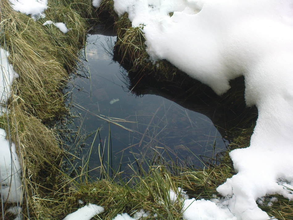
The Maiden’s Well pool
Earlier accounts tell of magickal rites that could be used to invoke the beautiful maiden, but once again dire consequences may befall the poor practitioner.
To this day, local people visit the well and make offerings to the spirit of the waters, as you’ll see if you come here. Some of the remains here are very old; and a visit not long ago indicated that offerings were made even when surrounded by depths of snow in the middle of a freezing winter.
References:
Baillie, Bruce, History of Dollar, DMT: Dollar 1998.
Fergusson, R. Menzies, The Ochil Fairy Tales, Clackmannan District Libaries 1985.
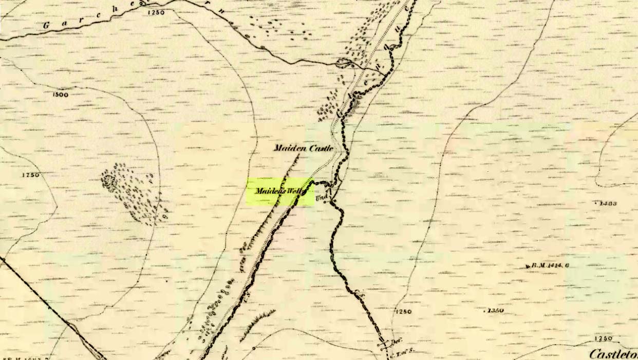
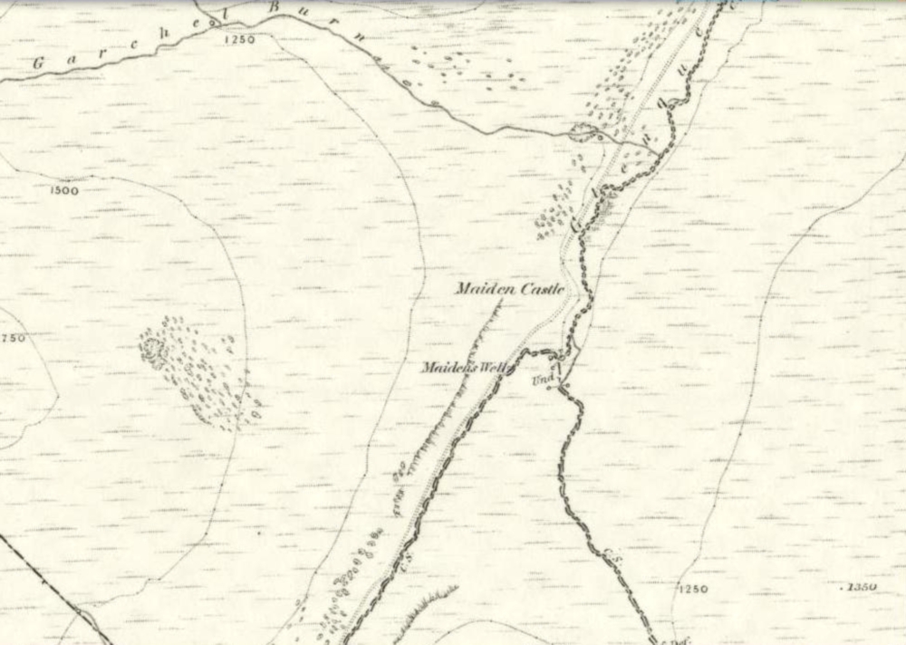
1860 map showing Maiden Castle (and the Maiden’s Well)
Take the small steep road uphill from the town of Dollar in Clackmannanshire towards Castle Campbell. Less than 100 yards above the small parking spot by the small white house near the top of the hill, turn to walk up the footpath on your right above the house, following the edge of the depleted forestry plantation parallel with the valley. Cross the valley a few hundred yards up, but keep to path on the other side that stays parallel with the stream. You’ll hit a small rocky glen a half-mile up. Walk thru it, alongside the very edge of the forest till the trees break and there’s a gap in the hills. You’ve just walked past the Maiden’s Well and in front of you is a large natural rounded hill, which the footpath bends around. This hill is the Maiden Castle. (if you walk round this, a view into the eastern hills and a small lake opens up ahead of you)
Archaeology & History
The fairy hill of Maiden Castle
A large rounded hill marking the opening of Glenquey to the north and the Glen of Care to the south. Although ascribed in place-names old and new as a ‘castle’, there are no remains as such left here to account for this title. Angus Watson (1995) tells of the possibility of the place deriving its name from the Gaelic Creag Ingheann, or maiden crag. In Bruce Baillie’s (1998) survey of the area, in trying to give some relevance to the place-name, he points out that whilst no hillfort or cairn that might help account for the folklore (see below),
“Large-scale maps indicate a spot opposite on Hillfoot Hill as Greig’s Grave. There would seem to be something ancient here but of what nature it is, at the moment, impossible to say.”
When we visited the place yesterday, snow still covered much of the ground hereby, so we couldn’t do our usual explorations seeking for old sites (even the hut circles 100 yards away were covered over). The legendary healing waters of the Maiden’s Well are below here, by the side of the burn.
Folklore
This large rounded hillock was evidently a place of some importance in bygone days if the folktale here is anything to go by. Although the story echoes the some of the core sequences of modern ‘close encounter’ abduction events, other ingredients here tell of more arcane peasant rites that were once part of the social structure of our ancient heathen tribes:
“A piper, carrying his pipes, was crossing from Glendevon to Dollar in the grey of the evening. He crossed the Garchil (a little stream running into the Quaich), and looked at the Maiden Castle and saw only the grey hillside and heard only the wind soughing through the bent. But when he had passed beyond it, he suddenly heard a burst of lively music and turned round to look at what was causing it. And there, instead of the dark knoll which he had seen a few moments before, he beheld a great castle, with lights blaring from the windows, and heard the noise of dancing issuing from the open door. He went back somewhat incautiously to get a closer view, and a procession issuing at that moment from the Castle’s open door, he was caught up and taken into a great hall ablaze with lights, while people were dancing on the floor. He was at once asked to pipe to them and was forced to do so, but agreed to do so only for a day or two. At last getting anxious, because he knew his people would be wondering why he had not come back in the morning, as he had promised to do, he asked permission to return home. The faeries seemed to sympathise with his anxiety and promised to let him go if he played a favourite tune of his, which they seemed fond of, to their satisfaction. He played his very best. The dance went fast and furious, and at its close he was greeted with loud applause. On his release he found himself alone in the grey of the evening, beside the dark hillock, and no sound was heard save the purr of the burn and the soughing of the wind through the bent. Instead of completing his journey to Dollar, he walked hastily back to Glendevon in order to relieve his folk’s anxiety. He entered his father’s house and found no kent face there. On his protesting that he only gone away for a day or two before, and waxing loud in his bewildered talk, a grey old man was aroused from a doze beside the fire, and told how he had heard when a boy from his father that a piper had gone away to Dollar on a quiet evening, but had never been seen or heard since, nor any trace of him found. It turned out the piper had been in the ‘Castle’ for a hundred years.”
The Fortean experts John Keel (1971) and Jacques Vallee (1970) both contended, quite rightly, that some aspects of the ancient encounters related in such folklore has strong parallels to modern UFO ‘abduction’ events. In addition, Paul Devereux (1989) cites that such events occur where strong geomagnetic forces exist in proximity to rock outcrops, as found here.
There is the additional feature in these stories of the music of both faerie and pipers alike, whose revelling jigs carry the mortal out of time and, when returning back to human life, find no one recognises them. This is a condition of some rites of passage in traditional societies, where mothers and fathers no longer recognise their child after they have been through the rituals after visiting spirit-lands and returning as adults for the first time: an element in our faerie-lore that has been overlooked in assessing the nature of these fascinating tales.
References:
Baillie, Bruce, History of Dollar, DMT: Dollar 1998.
Devereux, Paul, Earthlights Revelations, Blandford: London 1989.
Fergusson, R. Menzies, The Ochil Fairy Tales, David Nutt 1912.
Keel, John A., UFOs: Operation Trojan Horse, Souvenir Press: London 1971.
Rhys, John, Celtic Folklore – Welsh and Manx: volume 1, Oxford University Press 1901.
Vallee, Jacques, Passport to Magonia: From Folklore to Flying Saucers, Tandem: London 1975.
Watson, Angus, The Ochils: Placenames, History, Tradition, PKDC: Perth 1995.
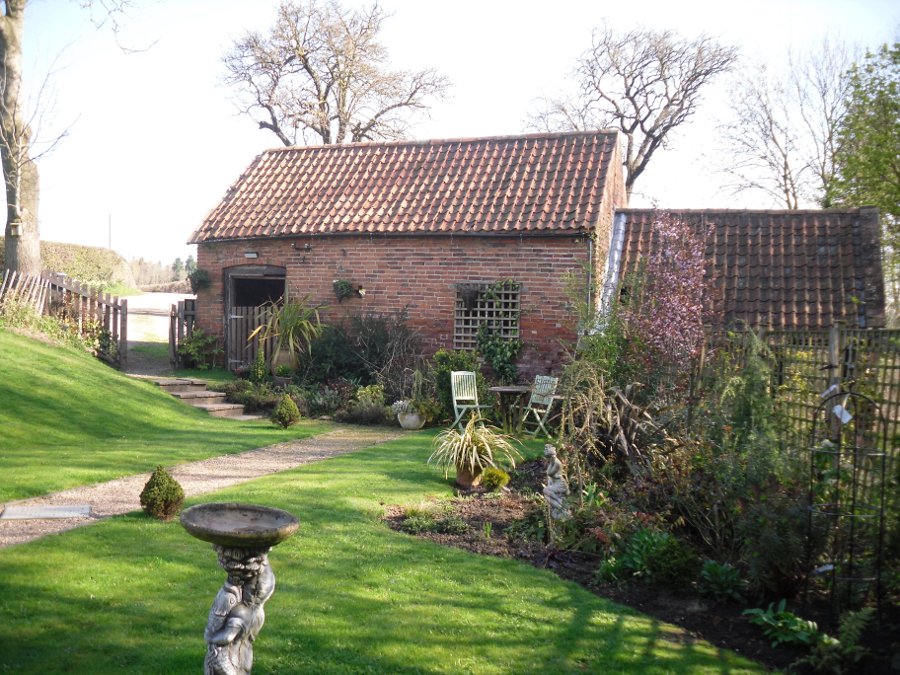
To find Westhorpe, take the lane on the left as one leaves Southwell, and then the next left, Bath Lane. The cottage is the only house on this lane and the well arises on the edge of its private garden. Ask permission to view.
Archaeology and History
The earliest record of a religious institution here is in 1482, when a chapel was erected dedicated to the saint. Whether this was built to cater for those who sought the well is unclear, but it seems likely. Little is recorded of its mediaeval history. Of its post-Reformation history, Dickinson (1819) notes that a Mr. Burton of Norwood Park built a house and bath at the site in 1720. He appears to have used the saint as support for its properties as:
“Over the head of the fountain was a plate, on which some Latin verses were inscribed, much to the honour of the tutelary saint, and the reputation of the water.”
Stone slab describing the wellThe running waters
It is thought that the cottage and barn at the site may be the remains of this venture, although, I was informed by the occupant that the barn had mediaeval features. When Bob Morrell (1988) visited he was also told that a bath-like structure with steps down was located nearby, but an exact location was unknown, and the current occupiers were similarly unaware of it when I visited. This was probably a relic of Mr Burton’s exploitation. This appears to have been a brief period, for as Shilton (1818) notes, it
“…would have retained them to this day, had there been the due accompanyments (sic) for luxurious lounge, intrigue and scandal commodiously attached.”
Modern stone wall above well
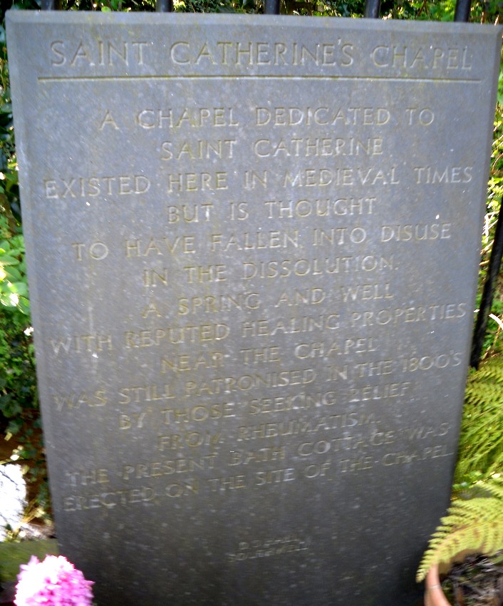
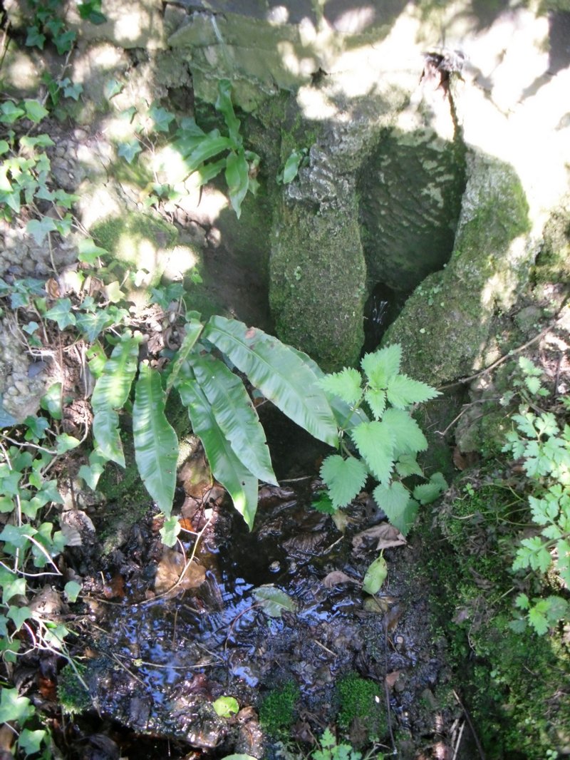
St. Catherine’s Well itself is found between Bath Cottage and the barn. It arises in a brick-lined square structure capped with a broken slab. This sits on an older structure which has the appearance of calcareous rock; although any petrifying properties are not noted by previous authors. When first visited the well house was dry; however, a more recent visit in spring showed a considerable flow (despite a dry winter). It flowed from a clay pipe within the well house and leaves through a smaller pipe set into the calcified part and then down to the dumble below. In this dumble appear to be some dressed stone which may have been part of the original structure. Beside the well on the bank above is a small slate monument which records:
“A chapel dedicated to St. Catherine existed here in medieval times but it is thought to have fallen into disuse at the dissolution. A spring and well with reputed healing properties near the chapel was still patronised in the 1800s by those seeking relief from rheumatism. The present bath cottage was erected on the site of the chapel. D.J Hall Southwell.”
Folklore
Not much but its waters were said to be a cure for rheumatism being particularly cold.
References:
Dickinson, W. (1787), A History of the Antiquities of the Town and Church of Southwell, in the County of Nottingham. Nottingham.
Morrell, R. W. (1988), Nottinghamshire Holy Wells and Springs. Nottingham
Parish, R.B. (2010), Holy wells and healing springs of Nottinghamshire. Nottingham
Rattue, James (1995), The Living Stream: Holy Wells in Historical Context, Boydell: Woodbridge.
Shilton, R. P. (1818), The History of Southwell in the county of Nottinghamshire. Nottingham.
Landscape of Giants Knowe (photo by Marion Woolley)
Amidst the colourful and nurturing landscape close to the gigantic Dunruchan standing stones and just along the road from the solitary Craigneich stone, in the field across the road above Straid farmhouse could once be seen a fascinating-sounding prehistoric site that has sadly been destroyed. Some of the remains of this old monument can be found in the field-clearance of stones just over the fence, above the top of the field (many fields round here have scatterings of large stone clearings at the field edges), but we have no detailed accounts of the site. It was mentioned in early notes by the Ordnance Survey to have been,
“A large circular heap of small stone and gravel entirely removed in 1831. An urn filled with ashes and several stone coffins were found under it.”
The local historian John Shearer (1883) later told us that,
“A small mound of earth on the farm of Strayd, called Crock-nafion or the Giant’s Knowe, or the Fingalian’s Knowe, was cleared away several years ago. An urn containing burnt bones was discovered.”
Any additional information about this site and its folklore, would be greatly appreciated.
Folklore
To the west along Glen Artney whence our view takes us from here, old legend told that the valley was once the abode of a great giant who lived in a cave in one of the mountains thereby. In mythic lore, giants were the creation deities of hills, mountains and other geological forms, whose narratives were overturned and demonized by the incoming christian cult many centuries ago. It is likely that this once great tomb was deemed as the burial-place of our local giant – which would make this prehistoric site neolithic in age. But — logical though it is — this idea is pure speculation…
References:
Hunter, John, Chronicles of Strathearn, David Philips: Crieff 1896.
Shearer, John, Antiquities of Strathearn, David Philips: Crieff, 1883.
On the level ground a half-mile south of the large Fairy Knowe prehistoric tomb, Bridge of Allan had a site of its own up until being destroyed sometime in the 19th century. Nothing much is known about the tomb – or “cist containing a skeleton”, as the Royal Commission (1963) lads called it – apart from the notes given in J.E. Alexander’s (1868) essay on the Fairy Knowe, where he told:
“It is right, however, to mention, that a few years ago, in digging the foundations of the house of Annfield, Bridge of Allan, at nine feet from the surface, there was found in the sand, and apparently undisturbed, a fine cist, containing the skeleton of a young female; and under the right arm was a small clay urn, corroborating the opinion of Professor Innes, that in many cases the so-called urn was simply a domestic jar to contain food for the deceased.”
A Mr R. Swift from Bridge of Allan told that the cist was located at the newly-named Lentran, along Kenilworth Road. Does anyone know anything more about it?
Royal Commission on the Ancient & Historical Monuments Scotland, Stirlingshire: An Inventory of the Ancient Monuments – volume 1, HMSO: Edinburgh 1963.
Thought to have been destroyed in the 19th century, folklorists and historians alike didn’t seem to be able to locate this little-known folklore relic, which is still alive and well in one of the fields by the village. The exact nature of the stone isn’t known for certain. Legend reputes it to have been one of the four boundary stones which gave the village its name; it was also said that they were Roman altars and the Fairy Stone was one of them, which was moved from the village boundary during the Rebellion of 1715 and placed nearer the centre.
Folklorist M.C. Balfour (1904) seemed to think that stone had gone when he wrote about it. Writing about it in the past tense, he told,
“The Fairy Stone however, certainly had an existence, for a person, 80 years of age, remembered its situation to the south of the village, near the old road, and that it was squared, and had a square “cistern hewn out of its top,” which was called the Fairy Trough, and traditionally said to have had a pillar fixed in it.”
But when former Ley Hunter editor Paul Screeton (1982) came looking for the stone in the late 1970s, he was fortunate in coming across an old local:
“Some time ago while looking for the Fairy Stone at Fourstones…I came across a farmer who pointed it out and remarked that a few years previously when the road was widened the local lengthsman made sure it was not destroyed, though it had to be moved a short distance.”
Folklore
Of the four boundary stones surrounding the village, they were “supposed to have been formed to hold holy water,” said Balfour (1904). But the title Fairy Stone given to one of them had this tale to account for it:
“A couple of miles or more down the South Tyne is Fourstones, so called because of four stones, said to have been Roman altars, having been used to mark its boundaries. A romantic use was made of one of these stones in the early days of “The Fifteen.” Every evening, as dusk fell, a little figure, clad in green, stole up to the ancient altar, which had been slightly hollowed out, and, taking out a packet, laid another in its place. The mysterious packets, placed there so secretly, were letters from the Jacobites of the neighbourhood to each other; and the little figure in green was a boy who acted as messenger for them. No wonder that the people of the district gave this altar the name of the ‘Fairy Stone’.”
References:
Balfour, M.C., Country Folk-lore volume 4: Examples of Printed Folk-lore Concerning Northumberland, David Nutt: London 1904.
Screeton, Paul, “The Long Man of Wilmington,” in The Ley Hunter, no.92, 1982.
Terry, Jean F., Northumberland Yesterday and Today, Andrew Reid: Newcastle 1913.
Watson, Godfrey, Northumberland Place Names, Sandhill: Morpeth 1995.
Acknowledgements: Big thanks to Paul Screeton for the grid-reference!
Probably the easiest (direction wise) is if you’re coming from Dick Hudson’s public house on the southern road surrounding Rombalds Moor. From the pub, head left (east) along Otley Road (passing Weecher reservoir) for 1.9 miles (3.1km) until you reach Reva reservoir where a track leads you to the waters. A small parking spot is on the left-side of the road. From here, go through the gate and along the footpath across the field for nearly 300 yards to the next gate; go through here and walk to your right for about 60 yards where uyou’ll reach a small straight dyke (keep your eyes peeled!) running NW (to your left): walk along here for nearly 200 yards until it hits another shallow dyke bearing right; follow this dead straight for 35 yards after which it changes direction, but you need to keep walking straight on forward for another 60 yards or so. Look around!
Archaeology & History
First photo of the carving
This carving is one in a cluster of previously unrecorded petroglyphs, uncovered in the summer of 2011 during a Northern Antiquarian bimble on the northern edge of Rombald’s Moor. The carvings were found as a bi-product of uncovering a previously undiscovered cairn circle, close to the Twelve Apostles stone circle. In assessing and exploring the newly-found circle, it was noticed that a small opening in the near horizon highlighted a rise in the landscape barely a mile away. This ‘opening’ in the land was not visible if you walked 25 yards either side of the cairn circle – but was very notable at the circle itself.
“We need to have a look at that site,” I said. “It’s position looks to have been relevant to this circle.” (or words to that effect) And a couple of weeks later we met up and walked to the place in question.
Fraggle Rock carving, looking westFraggle Rock carving, looking south
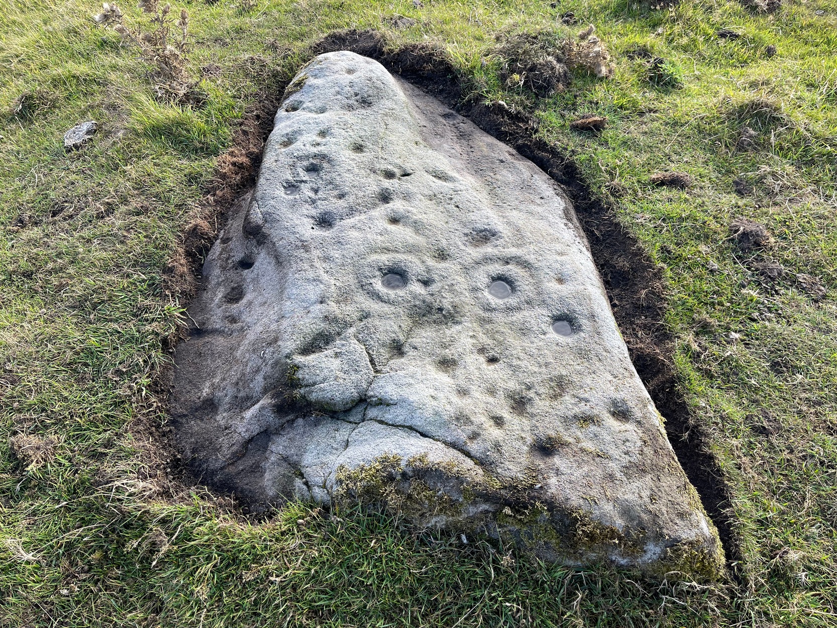
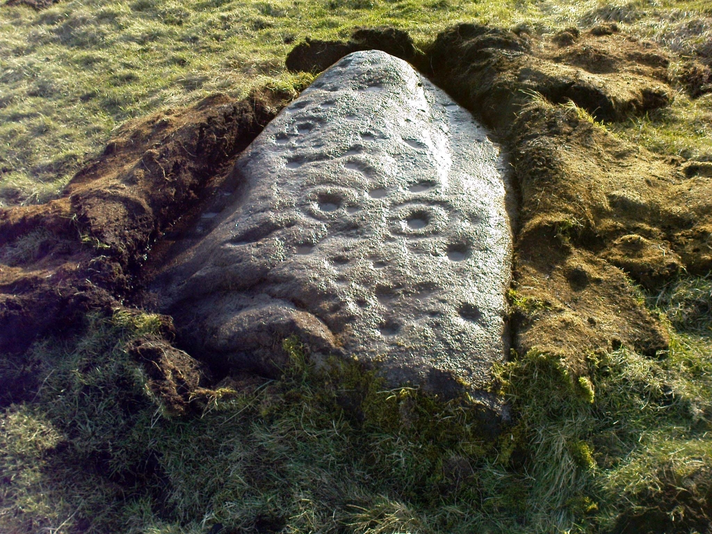
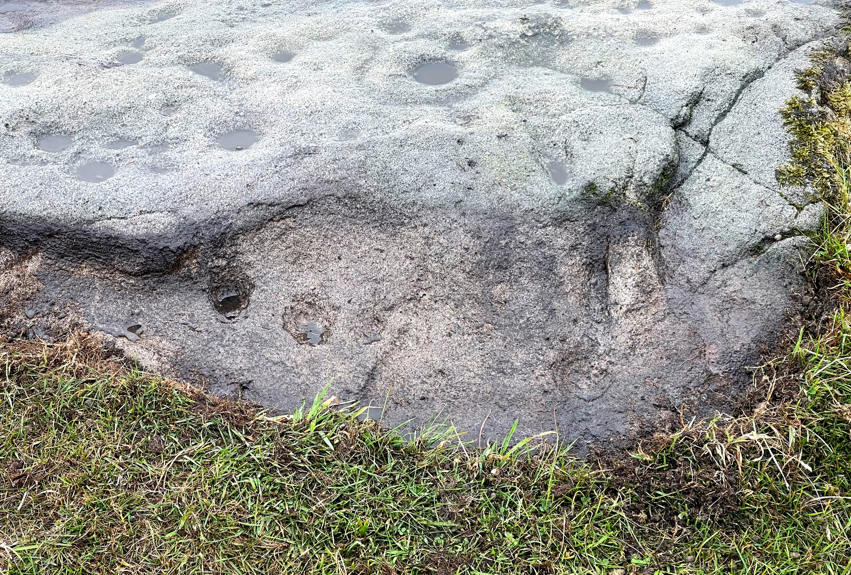
Within five minutes we came across a couple of previously unrecorded cup-marked stones, of simple design, right in line with the cairn circle. As we walked around this spot, then headed back in the direction of the circle, a cluster of small stones were noticed on the slope. One had what looked like a single cup-marking near its edge, but the rest of the rock was completely covered in vegetation. Paul Hornby and Michala Potts had, by now, already found several other previously unrecorded cup-marked stones close by; but as I carefully rolled back the vegetation at the edge of this particular rock, cups-and-rings and carved lines seemed to be covering most of its surface. It was a good one!
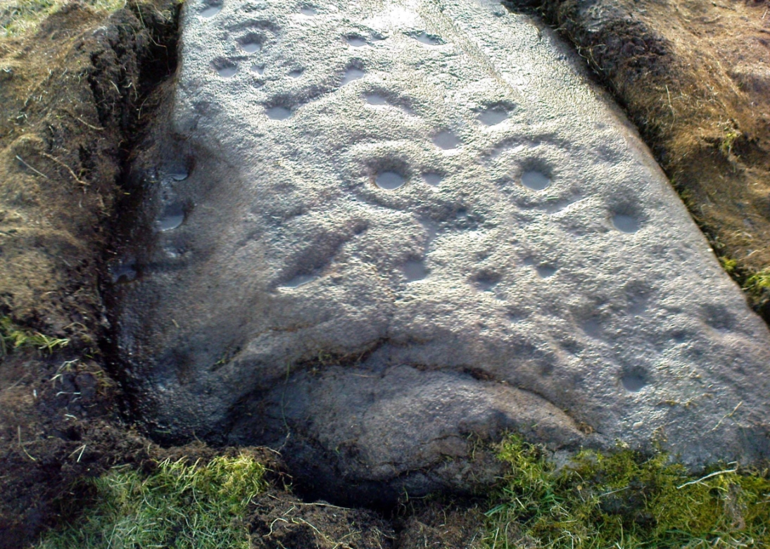
Face on the Fraggle Rock
We called it the Fraggle Rock after noticing that when you look at the stone from one end, the two main cup-and-rings are likes two large eyes carved above a large natural down-turning ‘mouth’ feature, similar to some of the creatures’ faces on the muppets or the similar kid’s TV show, Fraggle Rock! (sad aren’t we!?) The photo here shows you what we mean.
The primary design consists of at least 3 cup-and-rings, 2 partial cup-and-rings, 28 cups and several carved lines along which some cup-markings are linked to others. The most notable of the carved lines is the longest (barely visible in the photos), running from a single cup-mark at the southernmost rounded end of the stone, almost straight and parallel with a natural ridge or dip along the rock, until it meets the largest of the cup-and-rings (one of the eyes on the Fraggle’s face!). Don’t ask me why, but for some reason this long faint line seemed the most perplexing element of the carving.
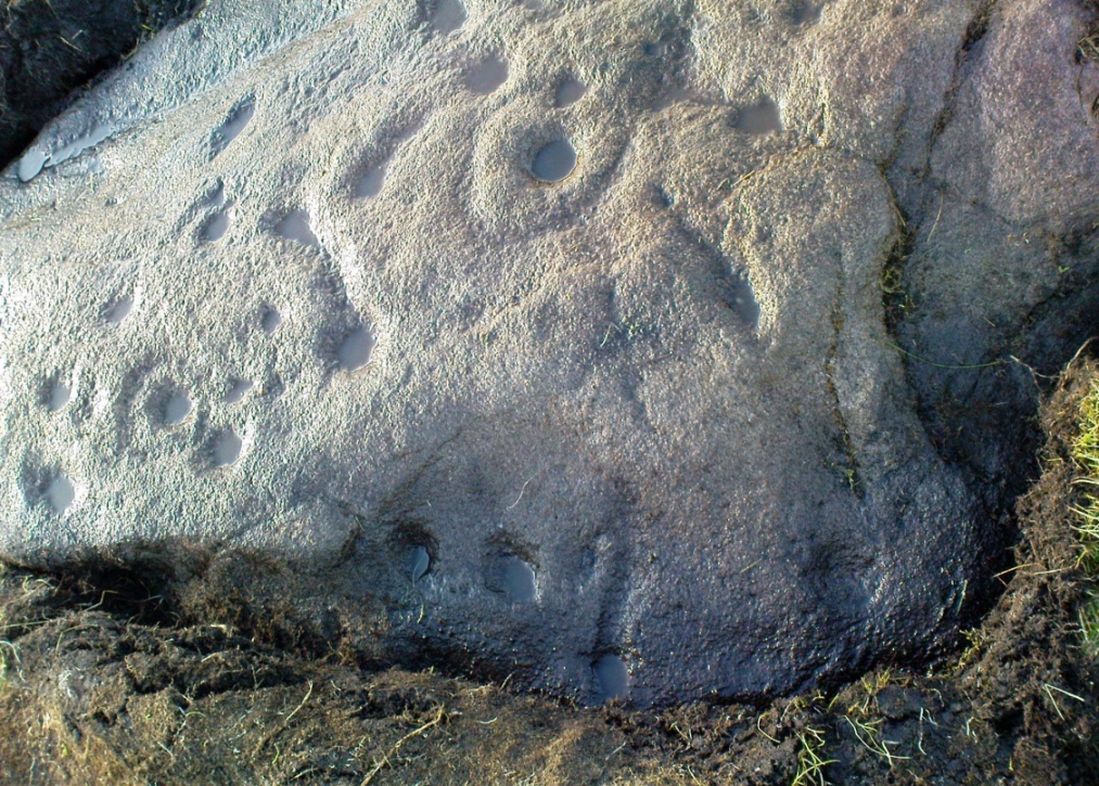
Eastern edge with low cupsCup-marks on rock edge
Most of the design is carved on the upper face of the stone, but a small part of the rock dips into the ground on its eastern side and a small group of cups and a single carved line, in a very good state of preservation, are etched right at the edge of the stone. Unusual. Another faint cup-and-ring is less than 100 yards west; and a fascinating cup-and-lines stone, with at least four long carved ridges running like hair from the top of the stone into the Earth, is a short distance to the north. A number of others are in this and adjacent fields.
One of the first photos, just as the mud had been cleared
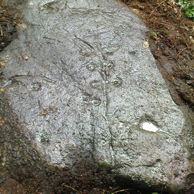
This carved stone was rediscovered by Michala Potts on the rainy afternoon of August 26, 2011, on a Northern Antiquarian excursion to explore some of the cup-and-rings on Ilkley Moor. The entire stone was totally covered in soil and leaves, and Michala spent some considerable time carefully clearing the dead vegetation to unveil the carvings beneath.
Close-up of cups & scars
This carving has at least 12 cup-marks on its slightly inclined surface, with several artificial carved lines and some that are obviously geophysical in origin. (we really could do with a geologist with a cup-and-ring fetish to accompany us on some of our outings!) But the main feature of this carving — as the photos here illustrate — appears to be the natural crack that runs up through the middle of the stone, either side of which have been etched a number of cup-markings attached by small lines or ‘branches’, giving the distinct impression of a tree. Whether this was a deliberate artistic feature (a tree), or just another Rorscharch response to non-linear systems on our behalf (more probable), we’ll never know. On the moors northeast of here on the other side of the Wharfe valley, the Tree of Life Stone acquired a similar association due to its design; but this Ilkley design, sadly, aint quite as good as the one on Askwith Moor.
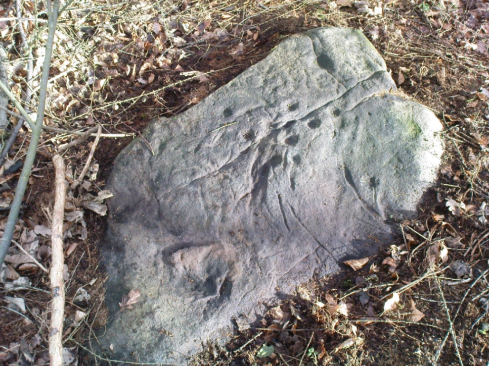
Tree Stone, showing modern industrial scars
There are some puzzles on this stone aswell. Other lines scar the rock which are definitely man-made, but they are of a different nature and age. The marks have been scarred by more modern metal tools, or were caused by heavy metal machinery that have rested on the rock at some time in the not-too-distant past. You can see the curved deep scratches in the photo here to the right. It seems likely that when the modern houses were built straight across and above here, this cup-marking was damaged by the workers — although they didn’t know it was here as the stone had not been catalogued by the Ilkley archaeologists. But there’s also another peculiar feature on this stone. Someone a century or two ago also carved other fainter features into the stone, seemingly lettering, on the northeast edge of the rock. They can be seen faintly on the second photo, above.
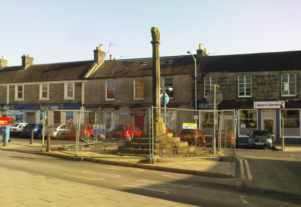
Dead easy to find. Get into the centre of the lovely little town centre of Kincardine, down High Street, and there upon its steps at the roadside, you can’t miss the it!
Archaeology & History
A few days ago when I came to have a look at this old cross (17th century according to the Royal Commission) it was surrounded by protective railings while some work was being done in the town centre. Thankfully it was a glorious bright day and allowed for some good photos!
It is a typical mercat cross, as Mair (1988) called them: a stone pillar, mounted on steps, with some sort of crowning edifice on top. The monument was described in the Royal Commission (1933) report of the region, where they wrote:
“The market cross stands at the southern end of High Street and consists of an octagonal shaft with moulded base and capital, placed on a rise of six octagonal steps, having a spread of 14½ feet. Above the square abacus is a stone sculptured with the arms of the Earls of Kincardine on the one side and a thistle ornament on the other. The arms are: Quarterly, 1st and 4th, a lion rampart; 2nd and 3rd, a saltire and chief. The shield is flanked by two men in armour as supporters, is surmounted by a coronet and helm, mantled and wreathed, and has for crest a naked arm, flexed, issuing out of a cloud and holding a man’s heart. The cross must be later than 26 December, 1647, when the Earldom was created.”
References:
Beveridge, David, Culross and Tulliallan: Its History and Antiquities – 2 volumes, William Blackwood: Edinburgh 1885.
Mair, Craig, Mercat Cross and Tolbooth, John Donald: Edinburgh 1988.
Royal Commission on the Ancient & Historical Monuments, Scotland, Inventory of Monuments and Constructions in the Counties of Fife, Kinross and Clackmannan, HMSO: Edinburgh 1933.
Small, John W., Scottish Market Crosses, Eneas Mackay: Stirling 1900.
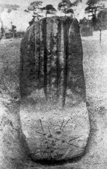
Similar in size and appearance to one of the cup-marked Tuilyies standing stones in Fife, Scotland, it was our old ley-hunter, Alfred Watkins, who described this stone in his Ley Hunter’s Manual (1927), along with giving us the old photograph taken by one of his mates here, which also showed the cup-and-ring carvings near the base of the stone. Are they still visible? (I’ve not been here, hence mi ignorance!) Watkins thought the cup-markings at the bottom represented some of the local leys—but unfortunately they don’t.
Folklore
Legend says that the deep grooves running down the stone were made by men sharpening arrow-heads on it (like a whetstone). There was also the usual christian Victorian fable that the stone was used by the druids and that the grooves on the stone were where the blood of their human sacrifices was channelled to the ground! The stone was also said to have some relationship with the nearby Calder Stones (which seems probable).
References:
Cowell, Ron, The Calderstones – A Prehistoric Tomb in Liverpool, Merseyside Archaeological Trust 1984.
Watkins, Alfred, The Ley Hunter’s Manual, London 1927.