St. Mark’s Well, Easterhouse, Glasgow, Lanarkshire

Holy Well (destroyed):  OS Grid Reference – NS 667 653

Archaeology & History

St Marks Well on 1864 map

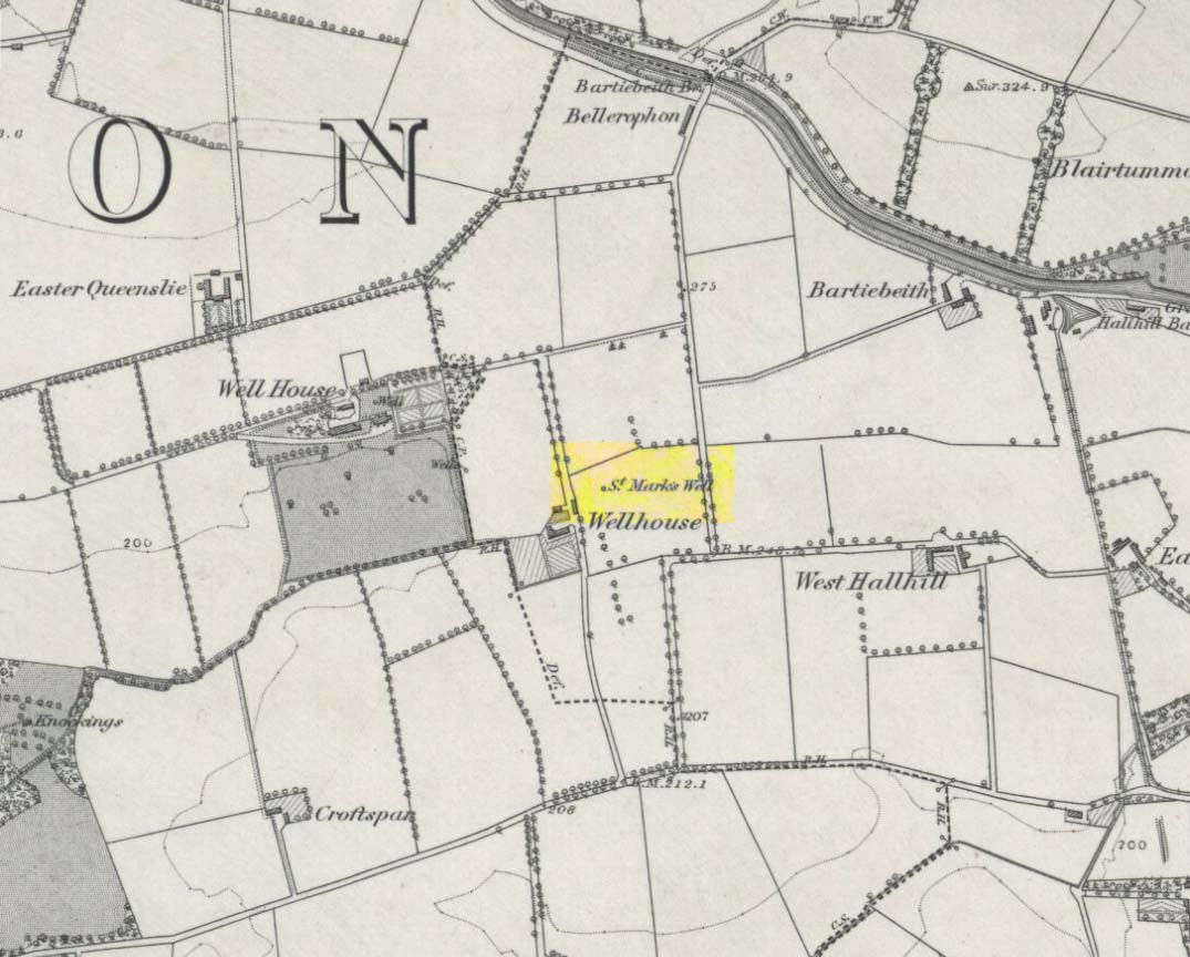
Information on this long forgotten holy well that once flowed a few miles east of Glasgow city centre, beneath what is now Wellhouse estate, is all but lost.  Local history works of the area tell us little (though there must surely be something somewhere?) and even the place-name surveyor of this area—Peter Drummond (2014)—could find nothing.  Noted by the Ordnance Survey lads in 1858, when they came to re-survey the area again in 1899 its waters had, it seems, been covered and carried into the ‘Well house’ less about 50 yards to the southwest (another ‘Wellhouse’ found 150 yards further west is the site that gives the estate its present name).  From thereon, this wellhouse and St. Mark’s Well fell into the forgotten pages of history and, sadly it seems, even its oral tradition has died…

The origin and nature of the ‘well house’ isn’t too troublesome, as Drummond (2014) explains:

“The name Wellhouse exists in several places in Scotland, and could indicate a ‘house beside wells’, or a protective ‘house over wells’; the early record here suggests the former, since the first Glasgow Water Company’s Act was obtained in 1806, many years later.”

However, the reasons behind the dedication to St. Mark at this probably heathen arena in times gone by, seems to be quite a mystery.  Perhaps the folklore of the saint concerned may be of some help.

Customs practiced on St. Mark’s Eve and St. Mark’s Day (April 24-5) are replete with animistic elements throughout and are certainly not christian!  Six months after the old New Year, we find rituals once more allowing, not for the passing of, but the emergence of the dead: bringing the spirits into the Spring and Summer. Divination rites were practiced with Cannabis sativa no less!  Prophecy and wise-women were advisors to the young.  Walking backwards around wells were known at some St. Mark’s wells; whilst others without his name—but on this saint’s day—were leapt across, symbolizing the crossing of danger and darkness in the ritual calendar. All around this period of time, up to and including Beltane, the end of the dark cold year has passed, and these plentiful rites are prequels to the lighter days, warm spring, summer and good autumn: all vital rites for the people in their myths of the eternal return…

St. Mark’s Well at Glasgow meanwhile, seems to have lost its old tales… Surely not?

References:

  1. Banks, M. MacLeod, British Calendar Customs: Scotland – volume 2, Folk-lore Society: Glasgow 1939.
  2. Bennett, Paul, Ancient and Holy Wells of Glasgow, TNA 2017.
  3. Drummond, Peter, An Analysis of Toponyms and Toponymic Patterns in Eight Parishes of the Upper Kelvin Basin, University of Glasgow 2014.
  4. Eliade, Mircea, The Myth of the Eternal Return, Arkana: London 1989.
  5. Greene, E.A., Saints and their Symbols, Sampson Low: London 1897.
  6. Hole, Christina, Saints in Folklore, M. Barrows: New York 1965.
  7. Wright, A.R., British Calendar Customs: England – volume 2, Folk-lore Society: London 1938.

© Paul Bennett, The Northern Antiquarian 


Silver Well, Shouldham, Norfolk

Holy Well (destroyed?):  OS Grid Reference – TF 6753 0817

Archaeology & History

Once found in the small woodland known as the High Plantation, this holy well has, seemingly, long since fallen back to Earth.  Mary Manning (1994) included it in her survey where she told that in earlier days it could be seen

“in a field which has drainage ditches and cultivation. Here was formerly marshy land draining to the Nar and lying on the south slope of the Nar valley.”

She thought that the title ‘Silver Well’ meant it was a holy site, but others told that it was due to a silver scum that formed on the surface of the waters—and it was a chalybeate (or iron-bearing spring) this is possible.

It was described in Francis White’s (1854) Directory of Norfolk for Shouldham:

“On Mr. Cotton’s estate is a fine chalybeate spring, called Silver Well, which gives rise to a small rivulet which passes through the village.  Near this a new spring was discovered about 20 years ago, and both of them possess similar properties to those of Tunbridge Wells.”

This secondary “spring” was another chalybeate well, above which a stone obelisk was erected in 1839.

Folklore

In relation to the object found in the well, Manning (1994) thinks “the objects found could have been pagan votive offerings in a venerated well.”  She also told that:

“The well is the subject of a local legend, which takes two forms.  One version is that at the Dissolution, treasure from one of the abbeys was hidden in the well.  The second says that workmen repairing the well brought up a container/box of silver ware, which was inadvertently dropped back and never recovered.  Both tales attribute the silver colour of the well water to the effect of passing over silver treasure.”

A variation on this was noted by folklorist W.B. Gerish (1892) who told that the silver which the workmen dropped back into the well, did so as a result of the devil fighting them over it, and they fled!

References:

  1. Anonymous, Kelly’s Directory of the Counties of Cambridgeshire, Norfolk and Suffolk, Kelly’s Directories Ltd 1925.
  2. Gerish, W.B., Norfolk Folklore Notes, 1892.
  3. Hope, Robert Charles, Legendary Lore of the Holy Wells of England, Elliott Stock: London 1893.
  4. Manning, M., Taking the Waters in Norfolk, NIAS: Norfolk 1994.
  5. White, Francis, Gazetteer and Directory of Norfolk, 1854.

© Paul Bennett, The Northern Antiquarian 


Grey Stone, Newsholme Dean, Oakworth, West Yorkshire

Cup-Marked Stone:  OS Grid Reference – SE 00621 40841

Also Known as:

  1. Carving no.2 (Boughey & Vickerman)

Getting Here

Grey Stone, Newsholme Dean

Take the same directions as if you’re visiting the Cob Stone Field carving; but instead of going into the field on your right, walk down the track about 100 yards towards the large barn below.  As you walk down keep your eyes peeled to the field on your left and, right up against the wall of the barn, you’ll see a large boulder resting quietly. That’s what yer after!

Archaeology & History

This large faded cup-marked rock whose western side has been split off in recent years, has a scatter of “up to 21 small shallow worn cups” on its upper surface.  They can be difficult to see in some light, but they’re definitely there (as Ray Spencer’s photos clearly show), fading slowly into Nature’s winds and storms.  A couple of ‘lines’ running down the edge of the stone are  due to modern farm-workings.

Close-up of the cups
Sketch of the design

Several other rocks in this and adjacent fields have what may be faded remains of other cup-markings, but without guidance from a geologist or a stone-mason, we can’t know for sure whether they’re authentic or not.  It’s likely that there are other authentic carvings hiding in this area—they just need sniffing out!

References:

  1. Boughey, Keith & Vickerman, E.A., Prehistoric Rock Art of the West Riding, West Yorkshire Archaeology Service 2003.

Acknowledgements:  Huge thanks to Ray Spencer for us of his photos in this site profile. Thanks Ray.

© Paul Bennett, The Northern Antiquarian 


Picketts Beck East, Askwith Moor, North Yorkshire

Cup-and-Ring Stone:  OS Grid Reference – SE 1708 5054 —  NEW FIND

Getting Here

Cup-and-ring stone in situ

From the Askwith Moor Road parking spot, head across the road and take the directions to the Woman Stone carving about 510 yards (467m) across the moors to the west.  From here, look straight down the slope and head towards the largest boulder at the bottom, 20-30 yards away.  About 10-20 yards to the right of this, zigzag about in the vegetation until you find the small stone amidst the bracken.  You’ll find it!

Archaeology & History

This small stone, whose natural contours and cracks have been utilised in the design of the petroglyph, may once have been part of a prehistoric tomb, perhaps rolled or thrown downhill from the nearby Askwith Moor Cairnfield.  I say this due to the size and portability of the stone, i.e., it’s small and barely earthfast, giving an increased likelihood that its present position was not its original one.  But we might never know…

Rough sketch of the design
Close-up of the carving

It’s almost archetypal in design, being a primary cup-and-ring, with what appears to be a faint inner ring etched marginally within the larger notable incomplete circle, just an inch beyond the inner central cup.  From this same cup runs a carved line, out to the near edge of the small stone.  Single cup-marks occur on the edges of the rock, as can be seen in the photos: three, possibly four of them.  One of the cups, where the stone narrows to a rounded point, may also have had a partial ring around it.  When we found this stone a few weeks ago, the day was grey and overcast and the light was poor, so our photos do not highlight the carving too well.

(Note: the OS grid-reference for this stone is an approximation: pretty damn close, but not close enough. If someone ventures here and can get the exact grid-ref, we’d be most grateful.)

© Paul Bennett, The Northern Antiquarian 


Wester Cairnfield (02), Askwith Moor, North Yorkshire

Cup-Marked Stone:  OS Grid Reference – SE 1698 5070

Getting Here

Faint cupmarks clearly visible

From the Askwith Moor Road parking spot, head west to the Askwith Moor cairnfield. Keep walking west, going downhill past the main cluster of rocks.  If you begin zigzagging amidst the heather hereby, you’ll eventually come across this relatively small stone which, even when the heather is deep, thankfully rises to the surface.  The Wester Cairnfield 1 carving is close by.

Archaeology & History

Although I presumed that Graeme Chappell and I found this petroglyph when we surveyed the area in the 1990s, I cannot find an early account of it in my files, so must presume that when James Elkington, James Turner and I came across it a few weeks ago, it was the first view of the stone in many a century… It’s another simple carving, only of interest to the mad rock art hunters out there.

...and from another angle
…and from another angle

When we first found it, it seemed to me (with the sunlight effects on the stone) that two cup-marks had been etched here; but as Mr Elkington pointed out, from the angle he was looking at the stone, there were another two.  He was right.  But it’s nothing special to look at, sadly, and is probably only of interest to the real hardcore petroglyph nutters amongst you. (please note that the grid-ref for this carving needs revising and may be 50 yards either side of the one given)

© Paul Bennett, The Northern Antiquarian 


Wester Cairnfield (01), Askwith Moor, North Yorkshire

Cup-Marked Stone:  OS Grid Reference – SE 16966 50674

Getting Here

Cup-mark near top-right

From the Askwith Moor Lane parking site, take the directions to the Askwith Moor Cairnfield.  Walk westwards for about 100 yards down the gradual slope, towards the boggy land below, but before reaching the reeds, still in the moorland heather, there are a scatter of rocks.  Just keep zigzagging about until you find it. It’s a reasonably large stone.

Archaeology & History

'Cup mark' on vertical face
‘Cup mark’ on vertical face

This is one of several simple cup-marked stones found down the slopes about 100 yards west of the Askwith Moor Cairnfield.  When James Elkington, James Turner and I re-surveyed this area again recently, I wondered whether it was a newbie or had already been located when Graeme Chappell and I did our tedious surveying of this region in the 1990s—and it turned out that we did!  The carving is nothing special to look at, even if you’re a petroglyph zealot.  Comprising of a distinct single cup-mark on the top nose of the rock, another is visible on the vertical south face, and another possible is on its eastern face.

1894 map of shooting target

When we look at the early maps of this area, we find that to the north and south of this stone once existed ‘Shooting Houses’.  As we can see on the attached map, the position of one of the shooting targets is very close to the location of this stone and so we must conclude that the cups on the vertical face were done by gunshot and are not prehistoric. However, the distinct cup on top of the stone retains its prehistoric link.

© Paul Bennett, The Northern Antiquarian 


Hawksworth Moor Cairnfield (01), West Yorkshire

Cairns:  OS Grid Reference – SE 140 443

Getting Here

One of Hawksworth Moor's cairns
One of Hawksworth Moor’s cairns, looking west

Take the same directions as if you’re visiting the Great Skirtful of Stones giant cairn on the boundary of Burley and Hawksworth.  Cross the wire fence on its southern-side and, cross the (usually overgrown) prehistoric trackway 50-60 yards away.  Keep in the same direction onto the pathless moor for about the same distance again, zigzagging back and forth, keeping your eyes peeled for some small overgrown rocky rises.  You’ll find ’em.

Archaeology & History

Not to be confused with the much larger Bronze Age graveyard further south on the same moorland, this little-known prehistoric cemetery has had little of any worth written about it since the 19th century and—like many sites on these moors—has received no modern archaeological attention.

Close-up of one of the cairns
Two of the cairns, looking NW

On my last visit to this site with James Elkington in 2015, only four of the heather-clad cairns were visible; but if you explore here after the heather has been burned away, a half-dozen such tombs are found in relatively close attendance to each other.  They are each about the same size, being roughly circular and measuring between 3-4 yards across, 10-12 yards in circumference and a yard high at the most. As you can see in the attached images, they are quiet visible even when the heather has grown on them.

Another cairn in this group

This small cairnfield may stretch across and link up with the secondary cairnfield a half-mile to the southwest.  More survey work is required up here.

As with the circle of Roms Law and the Great Skirtful of Stones, this relatively small cluster of cairns seems to have had a prehistoric trackway approaching it, running roughly east-west.  A short distance west are the much-denuded waters of the Skirtful Spring.

References:

  1. Bennett, Paul, The Old Stones of Elmet, Capall Bann: Milverton 2001.
  2. Faull, M.L. & Moorhouse, S.A. (eds.), West Yorkshire: An Archaeological Guide to AD 1500 (4 volumes), WYMCC: Wakefield 1981.
  3. Wardell, James, Historical Notes of Ilkley, Rombald’s Moor, Baildon Common, and other Matters of the British and Roman Periods, Joseph Dodgson: Leeds 1869. (2nd edition 1881).

Acknowledgements: Huge thanks to James Elkington for use of his photo in this site profile.

© Paul Bennett, The Northern Antiquarian


The Maypole, Alconbury, Huntingdonshire

Maypole (removed):  OS Reference Number TL 18554 75972

Getting Here

Maypole Square, outlined in red on the 1901 OS map

Maypole Square forms the junction of High Street, Church Way and Chapel Street in the centre of the village.

Archaeology & History

The Alconbury Maypole had passed out of living memory by 1942, but was historically attested by the ‘Maypole Square’ in the centre of the village.

Folklore

C.F. Tebbutt wrote in 1950:

“At Alconbury, it is remembered that about 1890 an old soldier, who lived in the corner house (east end) of the row of cottages facing Maypole Square, used to dig holes in the road opposite the row and set up May bushes there on May day”.

References:

  1. C.F.Tebbutt, “Huntingdonshire Folk and their Folklore”, in Transactions of the Cambridgeshire and Huntingdonshire Archaeological Society, Volume VI, part V, 1942.
  2. C.F.Tebbutt, “Huntingdonshire Folk and their Folklore II”, in Transactions of the Cambridgeshire and Huntingdonshire Archaeological Society, Volume VII, part III, 1950.

© Paul T. Hornby 2016 The Northern Antiquarian


Bogle’s Well, Glasgow, Lanarkshire

Sacred Well:  OS Grid Reference – NS 597 650

Archaeology & History

Of all the ancient wells in the city of Glasgow, this has to be one of the most intriguing! Descriptions of it are few and far between, but it is the name of the site which is of interest, to folklorists and occult historians alike.  For the word ‘Bogle’ is another term for a ‘boggart’ or goblin of some sort!  The well is mentioned in Andy MacGeorge’s (1880) excellent study in his description of ancient wells in the city. Citing notes from the 17th century, amidst many sites,

“Another was Bogle’s Well, in regard to which there is a minute of the town council “that Bogillis Well should be assayed for bringing and convoying the water of the same to the Hie street according to the right the town hes thereof,” and the magistrates are recommended to arrange for having this done “by conduits of led.””

…Obviously in the days when they were clueless about lead-poisoning!  The word ‘bogillis’ is the early plural form of the bogle, or bogill (Grant 1941:201).  But where exactly was this old well?  Are there any other records hiding away to help us locate its original position?  It seems to have been one in a cluster of legendary and holy wells in a very small area scattered between Glasgow’s cathedral, down the High Street and to the northern banks of the River Clyde… (the grid-reference given for this site is an approximation)

In a less esoteric fashion, the occult historian Jan Silver suggested that the name of the Well may relate to the family name, ‘Bogle’.  This could indeed be the real story behind the well’s name.

Folklore

Traditionally ascribed in the lower counties of England to be an evil malicious sprite, in more northern counties and in Scotland the creature was said by Katherine Briggs (1979) to be a more “virtuous creature”, akin to the helpful brownies or urisks of country lore.  This was said to be the case in William Henderson’s (1868) Folklore of the Northern Counties. Whether this well was haunted or the home of a bogle, we do not know as the folklore of this site appears to be lost; so I appeal to any students who might be able to enlighten us further on the place.  The Forteans amongst you might have a cluster of ‘hauntings’ hereby, perhaps….

References:

  1. Bennett, Paul, Ancient and Holy Wells of Glasgow, TNA 2017.
  2. Briggs, Katharine, A Dictionary of Fairies, Penguin: Harmondsworth 1979.
  3. Grant, William (ed.), The Scottish National Dictionary – volume 2, SNDA: Edinburgh 1941.
  4. Henderson, William, Notes on the Folklore of the Northern Counties of England and the Borders, W. Satchell: London 1879.
  5. MacGeorge, Andrew, Old Glasgow, Blackie & Son: Glasgow 1880.
  6. MacKinlay, James M., Folklore of Scottish Lochs and Springs, William Hodge: Glasgow 1893.
  7. Steele, Joyce, Seeking Patterns of Lordship, Justice and Worship in the Scottish Landscape, Glasgow University 2014.

© Paul Bennett, The Northern Antiquarian


The Maypole Tree, Little Paxton, Huntingdonshire

Maypole & Ritual Tree (destroyed):  OS Grid Reference TL 18831 62757

Getting Here

Imposing trunk of The Maypole Tree, right background

The road layout of the village has changed since the destruction of the Tree, but its approximate position was on the north side of the present High Street, at the junction with the east side of St James’ Road.

Archaeology & History

The Little Paxton Maypole Tree was a very late survival of a tradition where Mayday revellers danced around an actual tree rather than a symbolic tree in the form of a maypole.  It was described as “a tall straight elm tree” that stood in front of what was then the village Post Office, and from what may be the only surviving photograph, it appears that only the very substantial trunk survived of what was clearly a very old tree.

The 1887 6" OS Map, showing the Maypole Tree outlined in red
1887 6″ OS Map, showing the Maypole Tree outlined in red

A Miss Ethel Ladds, who had been born in Little Paxton, recalled in the early 1940s:

I remember the old tree very well, it was always called ‘the Maypole’, but I don’t know any more about it, except that they used to dance round it“.

The St Neots Advertiser recorded that the Maypole Tree was blown down in a great gale on 24th March 1895.

Folklore

While this writer has been unable to find direct folklore relating to the Little Paxton Maypole Tree, it may be worth remarking that botanically the Elm tree is a cousin of the Stinging Nettle, the Hop and Cannabis.  Another Elm Tree used for May revels was the Tubney Elm, near Fyfield in Berkshire and recorded by Matthew Arnold, in his ‘Scholar Gipsy’.

References:

  1. C.F. Tebbutt, “Huntingdonshire Folk And Their Folklore”, in Transactions of the Cambridgeshire & Huntingdonshire Archaeological Society, Volume VI, Part V, 1942
  2. C.F. Tebbutt, “Huntingdonshire Folk And Their Folklore”, in Transactions of the Cambridgeshire & Huntingdonshire Archaeological Society, Volume VII, Part III, 1950
  3. Gerald Wilkinson, Epitaph For The Elm, Arrow Books, London, 1979

© Paul T. Hornby 2016 The Northern Antiquarian