Healing Well (destroyed): OS Grid Reference – NS 5619 6654
Archaeology & History
Along the B808, between Beith Street and Byres Road, where it meets the main Dumbarton Road, the memory of Cooper’s Well is preserved in the street-name. It was one of more than a dozen springs in the area, but was one of the most renowned by local people.
Although not shown on the early OS-maps, thankfully the local historian and folklorist—and early environmentalist, it must be said!—James Napier (1873), gave a good account of it in his excellent work on the traditions of the area:
“Cooper’s Well was situated on the side of the road at the north-west end of Well Street, at the corner of where the Gas-work wall now is. It was about three feet deep, and had two steps leading down to the water from the road. Two sides and back were walled up higher than the road, and covered with a stone slab. It was celebrated in the neighbourhood as a drinking water, being strongly chalybeate, and therefore could not be used for cooking purposes. Although shallow, it was never frozen during winter (so that it must have come from a considerable depth), and it was cold in summer. On a warm summer Sunday evening we have seen people, not only from all parts of the village, but from the gentle houses in the neighbourhood, carrying water from the Cooper’s Well to drink. It is from this well the street has its name. The Gas-work dried up the well. There was a story current of some Glasgow people who were visiting at Mr. Sharp’s of Horslethill. Mrs. Sharp had been baking some oatcakes with butter or dripping in them, which caused them to be very fine and short. The Glasgow gentlemen were anxious to know how they were baked, and were told that they were baked with the Cooper’s Well water, some of which they had got a drink of. Shortly after some of the gentlemen sent out their servants to Partick for a supply of the water, but the servants could not succeed in making the cakes so nice as those got from Mrs Sharp. For long after this, butter-cakes were known in and around Partick as Cooper’s Well bread.”
I have to admit I’ve not visited this site, but presume that all trace of the site has disappeared.
Get onto the A763 road several miles east of Glasgow city centre and go along Gardenside Avenue onto the Carmyle estate. A few hundred yards on, turn right down Carmyle Avenue, then left onto River Road. Follow the footpath along the edge of the River Clyde for nearly a mile—past the recently destroyed John’s Well—until you hit the remnants of Kenmuir Woods. You’ll reach some large polluted pools and when you reach the gap between the first and second pool, walk into the trees above the river and the Well is there.
Archaeology & History
The decaying remains of this old well can still be seen, incredibly, in the small copse of trees that are Kenmuir Woods, just a few yards above the River Clyde, 160 yards below the M8 and the same distance west of the Daldowie sewage treatment works, with polluted water treatment pools just yards away! Not the sort of place you’d take a partner for any sort of marriage ceremony whatsoever nowadays! But it wasn’t always like this of course. Only since the Industrialists stamped their mark…
When Hugh MacDonald (1860) wrote the finest narrative of this arena in the middle of the 19th century, his evocative words painted the entire landscape with a veil untouched since his days. Indeed, it is truly like another world compared to the sacrilege of what we see today:
“It is a wild and bosky scene, covered with a picturesque profusion of timber, and is the habitat of flowers innumerable. The weaver herbalists of Camlachie and Parkhead find it a perfect storehouse of medicinal rarities; and on Sundays they may be seen in sickly groups prying into every green recess in search of plants which old Culpepper would have loved for their rare qualities, or carrying them home in odorous bundles, confident of having obtained a mastery over “all the ills that flesh is heir to.” The botanist may also occasionally be seen lurking here, vasculum in hand, or on bended knee, examining the structure of some strange flower. But even the mere general lover of flowers will here find much to reward his attention. At present the May-flower (Caltha palustris), the wild hyacinth, the craw-flower of Tannahill, the red campion (Lychnis dioica), the odorous woodruff (Asperula oderata), the globe-flower or lucken gowan (Trollius europœus), and many others are in full bloom, and so thickly strewn that even as the poet says, “You cannot see the grass for flowers.”
“At the foot of the bank, near its upper extremity, there is a fine spring, which is known by the name of the ‘Marriage Well,’ from a couple of curiously united trees which rise at its side and fling their shadows over its breast. To this spot, in other days, came wedding parties, on the day after marriage, to drink of the crystal water, and, in a cup of the mountain-dew, to pledge long life and happiness to the loving pair whom, on the previous day, old Hymen had made one in the bands which death alone can sever. After imbibing a draught of the sacred fluid from the cup of Diogenes, we rest a brief space on the margin of the well.”
One wonders how far back in time the attribution of ‘Marriage Well’ from the animism of the trees went; and whether marriage ceremonies were performed here, quietly, away from the prying eyes of the Church and invading english in centuries much earlier under the guidance of the Moon. It’s probable…
Nature’s cloak was still intact here when, many years after Hugh MacDonald’s visit, the local writer Dan McAleer (1930) informed us that,
“Shy bridesmaids and their groomsmen used to visit after a wedding to drink the mystic waters of the Marriage Well. Certain places about the woods were well adapted for picnics, etc. After tea and refreshments the lads and lassies passed hours in amusement trying to step over the well and anyone soiling the water in any way while stepping across it would not get married that year.”
Much of the beauty of the landscape and Her waters, and the rich romance that arises from Her cyclical forms are long gone from here now… Cold ‘progress’ bereft of the necessity of Nature’s sanctity is no progress at all… Although the genius loci of the place may have long since gone, at the very least the regional council—or decent locals, if the council can’t be arsed—could erect some memorial and save the failing Marriage Well from what seems to be its close and final demise….
References:
Carpenter, Edward, Civilization: Its Cause and Cure, George Allen & Unwin: New York 1914.
Healing Well (destroyed): Os Grid Reference – NS 5931 6500
Also Known as:
West Port Well
Archaeology & History
Once found near the old crossroads of Trongate, Arygle Street and Stockwell Street, the Trongate Well is another of old Glasgow’s lost sites, piped-off and added to the city’s water system sometime in the 19th century. A pity, as the fresh water from here was highly regarded (moreso than the modern stuff with its chlorine and other unnecessary additives). The well could be found where the Highland Gaelic Society built their own public house and, as a result, was very popular with local folk. It was,
“Opposite the old Black Bull in Trongate…afterwards covered in, which was famous in the palmy days of cold punch, and which is alluded to in Cyril Thornton as ‘the West Port Well.’” (MacGeorge 1880)
Old cattle markets were held here and MacGeorge (1880) wrote how it was a very popular and favourite place in its day, “surrounded by large numbers of the town’s people waiting a supply.”
The old Black Bull pub was much used by drovers and across from it was the old draw well, whose waters were of such renown that they were described in the verse, The Lament of Capt Paton, thus:
“Or if a bowl was mentioned,
The Captain he would ring,
And bid Nelly to the West Port,
And a stoup of water bring;
Then he would mix the genuine stuff,
As they made it long ago,
With limes that on his property
In Trinidad did grow.
O! we ne’er shall taste the like
Of Captain Pateon’s punch no mo’!”
Healing Well (destroyed): OS Grid Reference – NS 594 645
Archaeology & History
Mentioned briefly in James MacKinlay’s (1893) classic survey, this site was an ancient draw-well sunk near the old city centre but, like the ancient Moot Hill close by, has long since been destroyed. It is described amidst Andy MacGeorge’s (1880) historical survey of the ancient wells where he wrote:
“There was another…at the Barras Yet, near the port of that name at the foot of Saltmarket. It is mentioned in a minute of council in 1664, which ordains that ‘in respect of the heighting of the calsay at the Barrazet the well there be heightit twa stones higher round about, for preservation of childerin falling therein.’”
Although its exact whereabouts is not known, the proximity of the old fountain known as the Sir William Collins Memorial Fountain 100 yards east into the Glasgow Green Park at the bottom of the Saltmarket, might have robbed the Barrasyett Well of its water supply to gain existence.
Healing Well (destroyed): OS Grid Reference – NS 5996 6406
Also Known as:
Arms Well
Archaeology & History
1865 OS-map of Arns Well, Glasgow
Taking its name from the local dialect word relating to Alder trees (Alnus glutinosua) that grew above the source of the waters, Arns Well had already been destroyed by the end of the 19th century, but prior to this it was renowned as one of the social gathering places in Glasgow Green. Highlighted on the original Ordnance Survey of the area in 1865, Arns Well was also a place where artists and poets gathered – and a number of old prints of Glasgow were drawn from here.
Originally the waters emerged from marshy ground and used to be known as “the Peat Bog,” but by 1777 a small well house was built to contain the waters and make it a feature in the wider architectural landscape of the Glasgow Green park area. Once the spring had been channelled, its waters “were considered to be amongst the best to be had in Glasgow, particularly for making tea and adding to whisky.” In James Clelands’s (1813) municipal survey of the area he told how some thought that the water supply from Arns Well was “inexhaustible.”
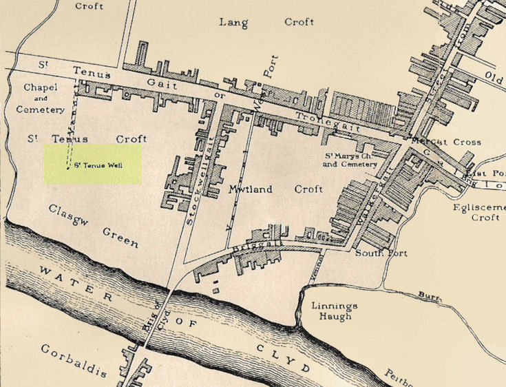
Whilst I’m in Glasgow (big thanks to Aisha!) I thought I’d check out any remaining heathen sites that might still be visible. Many have perished of course, beneath the weight of religious industrialism—this one included. Even when the Ordnance Survey lads came here in 1858, it had already been destroyed. All that we now know of it comes from the writings of the earlier historians like Walker (1883), Renwick (1921) and co.
Known in early records as St. Theneu (mother of the legendary St. Mungo, who also had sacred wells dedicated to him in Glasgow, Gleneagles and much further afield), trackways and burns hereby were also named after this curious character, and a chapel was also commemorated to her, which fell into ruin several centuries ago. Its position was highlighted on a late-16th century sketch of Glasgow village—as it was then—immediately south of the chapel, just north of the River Clyde. The best description we have of it comes from a detailed paper on the holy wells of Glasgow by a Mr Brotchie (1920), who told:
“Where the subway station of St. Enoch’s Square stands…there was at one time the well of St. Tenew, the mother of St. Kentigern or Mungo. It is thus described by a writer in 1750, “The ruins of a small chapel stood beside the well whose waters were sheltered by a bush, on which were to be seen, especially in early summer, bits of rags of all kinds and colours, while in the well itself enterprising boys were wont to get small coins. The rags and the coins were the offerings of people, principally women, who came to drink of the waters of St. Tenew’s Well, and left these trifles as thank offerings.”
“This ancient well of St. Tenew stood near a chapel erected over the tomb of St. Tenew, and the ground in its vicinity remained sacred in the eyes of the faithful as the last resting place of the holy woman who had watched the infant steps of the great apostle of the Cambrian Britons, St. Mungo, the patron saint of Glasgow. The Trongate and Argyle Street, which now stretch westwards from the cross, were in old times a country road leading to St. Tenew’s chapel, kirkyard and holy well. In a deed of 1498 mention is made of “the blessed chapel where the bones of the beloved Tenew, mother of the blessed confessor, Kentigern, rest.” When M’Ure wrote his History of Glasgow in 1736, the remains of this old chapel and kirkyard were described as standing “in a solitary spot in the country surrounded by cornfields.” Looking westwards from St. Tenew’s Well in 1750, a writer describes the scene as “open country, pastures and cornfields, rude-looking country homesteads, barns and other farm buildings, and enclosed kailyards,” where now stand the busy arteries of Jamaica Street, the Caledonian Railway Station, and the miles of tenements that stretch westward to Anderston, Finnieston and Partick.
“We have a comparatively recent record of the holy well of St. Tenew in the statement of the late Mr Robert Hart, who told M’George that he had been informed by an old man, a Mr Thomson, who had resided in the neighbourhood of St. Enoch’s Square, that in the beginning of the last century, say 1800, he recollected the well being cleaned out, and of seeing picked from the debris at the bottom many old coins and votive offerings. St. Tenew’s Well was a holy well. For centuries it was a place of pilgrimage and was much resorted to for cures, especially in pre-Reformation days. In 1586, James VI, addressed a letter to Mr Andrew Hay, commissioner for the west of Scotland, condemning the practice of people making pilgrimages to wells and chapels, but the royal edict was powerless to stop the practice and St. Tenew’s Well was resorted to by people in trouble as long as it was in existence. The road that led to it was known up to the 15th century as St. Tenew’s Gait or path. Indeed, it was so named till 1540, when the name of Trongate begins to make its appearance in old city deeds. This name, of course, owes its origin to the granting in 1490 by James IV, to the Bishop of Glasgow of the privileges of a free tron in the city—hence our Trongate of today.”