Very little is now known about this sacred site that was once found “a few hundred yards east from the New Church at Low Harrogate.” (Hunter 1830) Even most of travellers and medical experts who wrote about the numerous Harrogate wells in the 18th and 19th century bypassed its quietude; and by the time Mr Hunter wrote about it in his great descriptive catalogue, its healing or medicinal qualities had been forgotten.
He told that “the spirit in the water…or that with which it is infused, has long been most actively engaged in adding real or fancied comforts to the (Harrogate) Fair, and is now in much more general use” than the two other holy wells in the town. It was, he said, “the best water for making tea and more extensively used for that purpose than any in the neighborhood of Harrogate.” It would also appear to have been built over at some time in the not-too-distant past…
Folklore
St Ann (saint’s day – July 26) was a giant in early christian and Islamic myths. An apocryphal figure, She was the Great Mother of the mother of Christ—the Virgin Mary—and was Herself a Virgin until, in Her old age, after seeing a bird feeding a chick, decided She wanted a child and so eventually gave birth to Mary. An old woman giving birth when the Springtime appears (when birds and other animals become fertile) is the same motif found in the lore of the Cailleach in Ireland and Scotland (and parts of northern England). Pre-christian lore at this old well would seem evident here.
References:
Hunter, Adam, The Waters of Harrogate and its Vicinity, Langdale: Harrogate 1830.
Healing Well (covered): OS Grid Reference – TQ 6000 3963
Archaeology & History
Shown on early OS maps as a chalybeate spring, the denuded remains of this site can still be seen in Dunorlan Park, between the tearoom and the lake, where the spring can be seen on the left beneath a large tree. It was first described in John Britton’s (1832) famous account of the area, who told us:
Site shown on 1872 map
“There is a spring, called Burnt House Spring, situated in a little dell, in a romantic spot to the right of the road leading from Tunbridge Wells to Pembury. It is a good chalybeate, and the iron is in a state of carbonate. This spring rises rapidly into a stone basin, placed in the centre of a circular excavation, about ten feet in diameter and six or eight feet deep, which is bricked round, and with the remains of stone steps leading down to the basin at the bottom. This spring, therefore, has clearly been, at some time, made use of as a medicinal water. It was accidentally discovered choked up with rubbish. The country about Tunbridge Wells abounds with springs of this character.”
The spring was cleaned up some time ago and its waters rise in a square stone-lined chamber—accessed by four stone steps—into a circular stone basin, before flowing down a short channel and into the drains. I’ve no idea whether or not the water is still drinkable.
References:
Britton, John, Descriptive Sketches of Tunbridge Wells and Calverley Estate, Longman: London 1832.
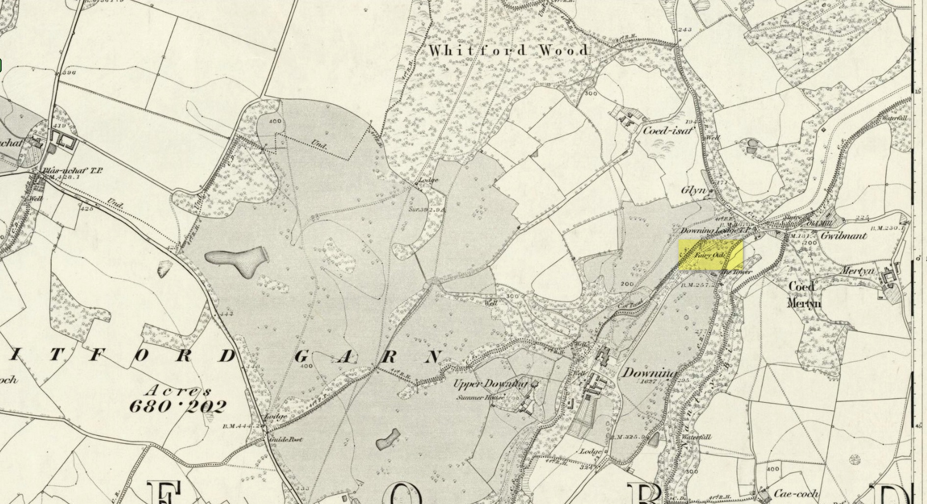
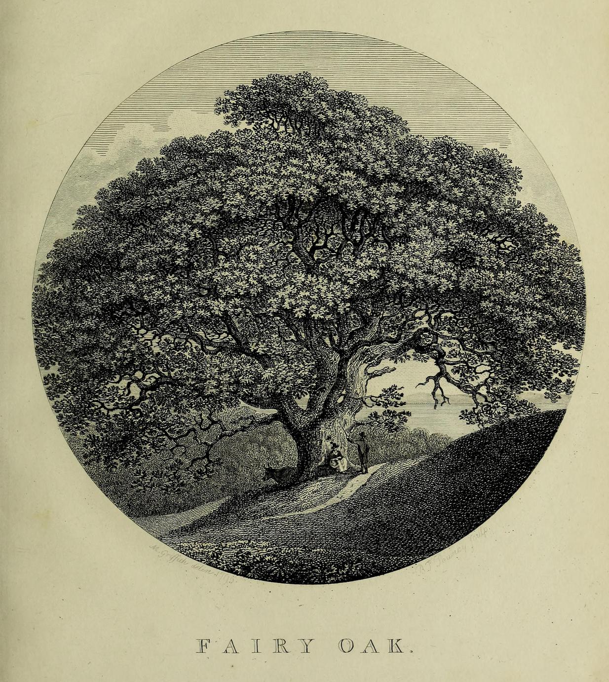
Highlighted on the earliest Ordnance Survey map of the region in 1878 and described much earlier by Thomas Pennant (1796)—almost as legendary as the fairies themselves in some parts—this ancient tree was obviously a place of great repute in the mythic history of the people in previous centuries. Animistic relationships with the landscape were still deeply embedded in the daily lives of our peasant communities all across the country when Pennant wrote about this place. In his antiquarian history of the area he described the great mansion of Downing Hall and in its grounds the ruins of Molandina Abbey. “Above this,” he wrote,
Fairy Oak on the 1878 mapPennant’s 1796 drawing
“is a spreading oak of great antiquity, size, and extent of branches: it has got the name of the Fairy Oak. In this very century a poor cottager, who lived near the spot, had a child who grew uncommonly peevish; the parents attributed this to the fairy, and imagined that it was a changeling. They took the child, put it in a cradle, and left it all night beneath the tree, in hopes that the tylwydd têg, or fairy family, or the fairy folk, would restore their own before morning. When morning came they found the child perfectly quiet, so went away with it, quite confirmed in their belief.”
Nearby, and in the same grounds of the mansion, Pennant told there to be an even older and greater oak tree that “has in it furrows so deep, and of aspect so uncommonly venerable, as to render its shade as worthy of the solemn rites of the Druids.”
References:
Pennant, Thomas, The History of the Parishes of Whiteford and Holywell, B. & J. White: London 1796.
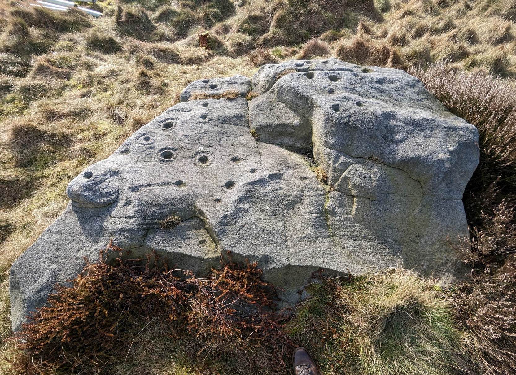
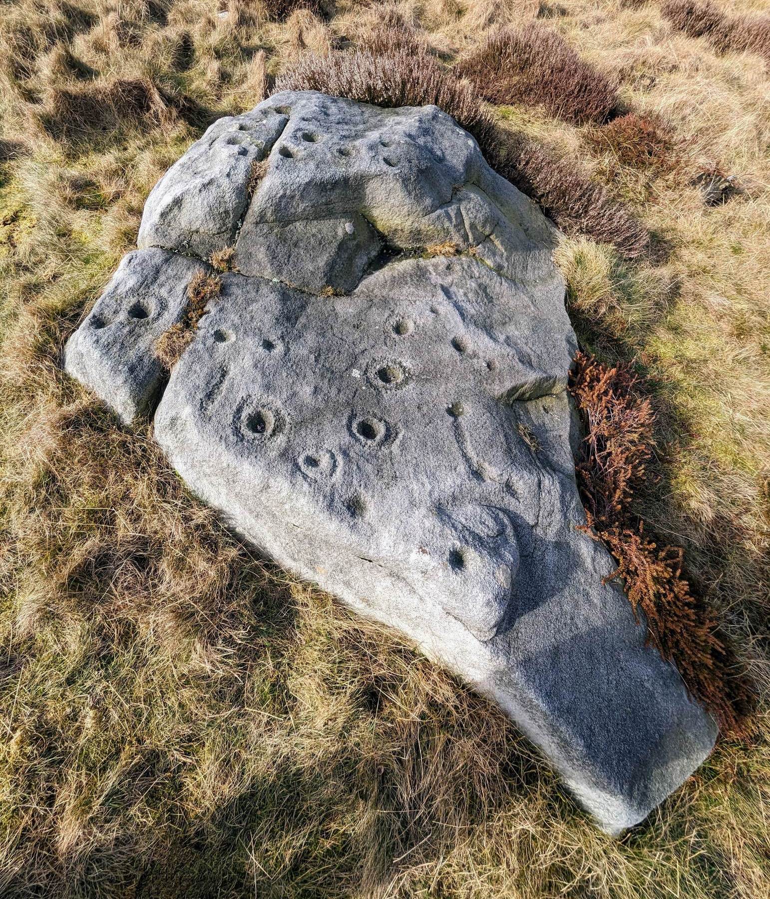
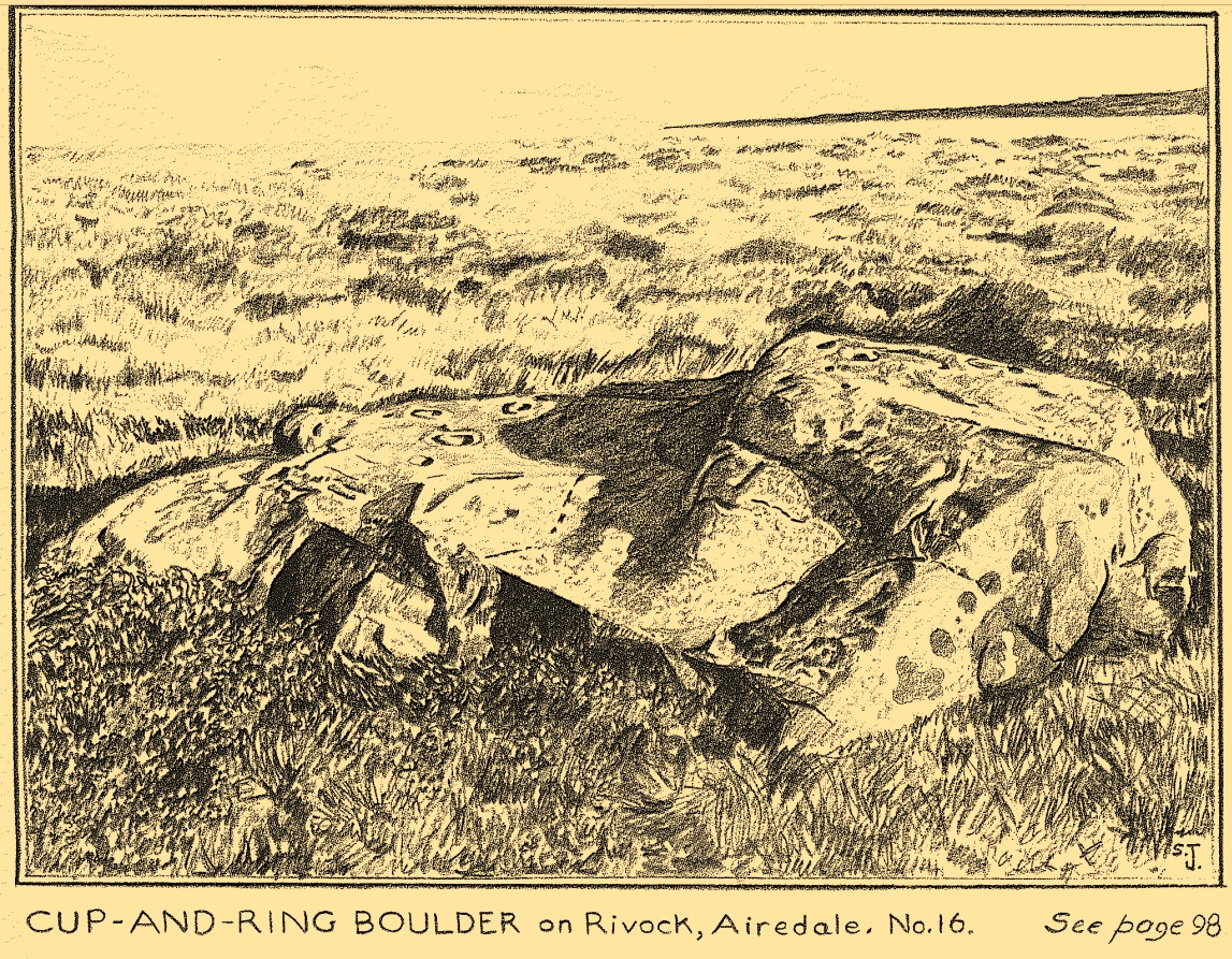
The best/easiest way to approach this and the Rivock carvings as a whole is to reach the Silsden Road that curves round the southern edge of Rombalds Moor (whether it’s via East Morton, Riddlesden, Keighley or Silsden) and keep your eyes peeled for the singular large windmill. About 200 yards east of this is a small parking spot, big enough for a half-dozen vehicles. From here walk 450 yards east along the road till you hit the dirt-track/footpath up towards the moor. Follow the track up for about 400 yards and you’ll see the crags a half-mile ahead of you. Get up there to the Wondjina Stone and follow the walling east for about 175 yards where you’ll see a track-cum-clearing in the woods. Walk along and the first large stone on your left is what you’re after.
Archaeology & History
I first visited this carving in my teenage years in the 1970s, before the intrusive so-called “private” forest covered this landscape and when its petroglyphic compatriots were easier to find. Thankfully this one’s still pretty accessible and possesses a damn good clear design. It was rediscovered in the 1960s by Stuart Feather and his gang, zigzagging their way across the open moors, pulling back the heather to see what they might find. His description of it told how the stone,
“has two roughly level areas, one 18ins and the other 2 feet above ground level. Both (levels) have several well-preserved cup-and-ring markings on them. There are eight single cup-and-rings and 18 cups, two of the latter being joined by a clear channel seven inches long and 1½ inches wide. Nearly all the markings are unusually well preserved and the pocking marks are very clear.”
Note the line running down
He also had “the impression that all the markings on this stone and possibly one other similar stone in the Rivock area have been carved by the same hand, as all the symbols are nearly identical in in type, size and execution.” (this other carving he’s referring to seems to be one about 170 yards to the north, where occasionally “offerings” have been found)
The design from E-W
When John Hedges (1986) and his team checked the stone out he could only make out “seven cups with single rings, twenty two other cups”; whilst the ever descriptive Boughey & Vickerman (2003) saw “twenty-nine cups, eight with single rings.” Eight cup-and-rings is what most people see when the light’s right. There’s also a long, bent carved line on the lower level of the rock, running from near the middle of the stone out to the very edge. It seems to be man-made (although I may be wrong) – and I draw attention to it as this same feature exists on at least three of the other large and very ornamental cup-and-rings hereby within 300 yards of each other – and on these other carvings the long “line” is definitely artificial. Tis an intriguing characteristic…
Stuart Feather’s old sketch
When visiting this petroglyph you’ll notice how some of the carved elements on top of the stone are more eroded than those on the lower section. This is due to the fact that the lower section was only revealed by Feather and his team in the mid-20th century, after it had been covered in soil for countless centuries. As a result you can still see the peck-marks left by the implements that were used to make the carving, perhaps 5000 years ago!
The name of the stone was inspired by a local lady who saw an astronomical function in the design (I quite like it as well). Examples of petroglyphs representing myths of heavenly bodies have been described first-hand in some tribal cultures and, nowadays, even a number of archaeologists are making allusions about potential celestial features in some carvings in the British Isles. That doesn’t mean to say that it’s correct, but the idea’s far from unreasonable…
Anyhow – check this one out when you’re next up here. You’ll like it!
References:
Bennett, Paul, “The Prehistoric Rock Art and Megalithic Remains of Rivock & District (parts 1 & 2),” in Earth, 3-4, 1986.
Boughey, Keith & Vickerman, E.A., Prehistoric Rock Art of the West Riding, WYAS 2003.
Deacon, Vivien, The Rock Art Landscapes of Rombalds Moor, West Yorkshire, ArchaeoPress: Oxford 2020.
Feather, Stuart, “Mid-Wharfedale Cup-and-Ring Markings – no.16 – Rivock,” in Cartwright Hall Archaeology Group Bulletin, volume 8, no.10, 1963.
Hedges, John (ed.), The Carved Rocks on Rombalds Moor, WYMCC: Wakefield 1986.
Morris, Ronald W.B., “The Prehistoric Rock Art of Great Britain: A Survey of All Sites Bearing Motifs more Complex than Simple Cup-marks,” in Proceedings of the Prehistoric Society, volume 55, 1989.
Acknowledgments: Huge thanks to Collette Walsh for use of her photos.
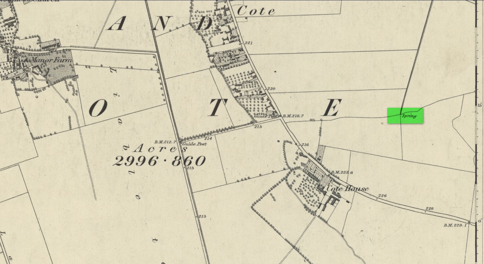
First mentioned as the field-name Holywellefield in the Court Roll of 1432, there is a possibility that this seemingly lost site still exists. It was mentioned briefly in John Giles’ (1848) old history book of the area where he told us that, “a field beyond Cote House on the road to Shifford is still called ‘Holy-well field’, (but) no legend has been recorded.”
If we go 400 yards northeast across the field on the other side of the road from Cote House, a “Spring” that was shown on the early OS-maps would still seem to be actively feeding a dyke that runs roughly north from here. This is probably the holy well that was described in those Court Roll records—and it still seems to exist.
References:
Gelling, Margaret, The Place-Names of Oxfordshire – volume 2, Cambridge University Press 1954.
Giles, J.A., History of the Parish and Town of Bampton, privately published: Bampton 1848.
Acknowledgements:Huge thanks for use of the Ordnance Survey map in this site profile, reproduced with the kind permission of the National Library of Scotland.
I’ve already added a site-profile of the standing stones that used to be close to this loch, and added to it the folklore below; but I realised that for students of water-lore, a separate profile for the loch itself is needed. For those of you who are not into water-lore, I hope you can forgive this repetition.
The loch, its associated chapel and the standing stones were visited at the end of the 17th century by John Brand, who gave a good account of the rituals performed by local people at the time. They regarded the waters here as very special indeed, with great medicinal powers. The loch had sense of sacrality whose nature was intimately tied to the repetition and regeneration of the seasons, valorizing the healing function of the waters.
By the edge of the loch stood St Tredwell’s church, outside of which was a cairn of stones. When people visited here to be cured of their various ailments, they would pick up one of them and cast it into the loch as an offering (some folk would cast money), so that its waters would heal their illness. According to Mr Brand and the local minister, such cures were numerous. The narrative is truly fascinating. Brand told us that,
“nigh to the east end of which this chapel is, is held by the people as medicinal, whereupon many diseased and infirm persons resort to it, some saying that thereby they have got good; as a certain gentleman’s sister upon the isle, who was not able to go to this loch without help, yet returned without it; as likewise a gentleman in the country who was much distressed wifh sore eyes, went to this loch, and washing there became sound and whole, though he had been at much pains and expense to cure them formerly. With both which persons he who was minister of the place for many years was well acquainted, and told us that he saw them both before and after the cure. The present minister of Westra told me that such as are able to walk, use to go so many times about the loch as they think will perfect the cure, before they make any use of the water, and that without speaking to any, for they believe that if they speak this will marr the cure: also he told that on a certain morning not long since he went to this loch and found six so making their circuit, whom with some difficulty he obliging to speak, said to him they came there for their cure.”
For the curing of sore eyes, the loch was specifically resorted to at Easter and during Lent. Traditions such as these are found at other lochs in Scotland and at lakes in many other parts of the world.
Another interesting feature related to the element of Kingship; for the waters of the loch were said to turn red when anything important was going to happen to a member of the royal family.
St Tredwell herself—also known as St. Triduana—has her saints day on October 8.
References:
Banks, M. MacLeod, British Calendar Customs: Orkney and Shetland, Folk-lore Society: London 1946.
Black, G.F., Examples of Printed Folk-lore Concerning the Orkney and Shetland Islands, Folk-Lore Society: London 1901.
Brand, John, A Brief Description of Orkney, Zetland, Pightland Firth and Caithness, George Mosman: Edinburgh 1701.
Eliade, Mircea, The Sacred and the Profane, Harcourt: New York 1959.
Fergusson, Robert M., Rambling Sketches in the Far North, Simpkin Marshall: London 1883.
MacKinlay, James M., Influence of the Pre-Reformation Church on Scottish Place-Names, William Blackwood: Edinburgh 1904.
Holy Well (destroyed): OS Grid Reference – NT 3190 3339
Also Known as:
St Bryde’s Well
Archaeology & History
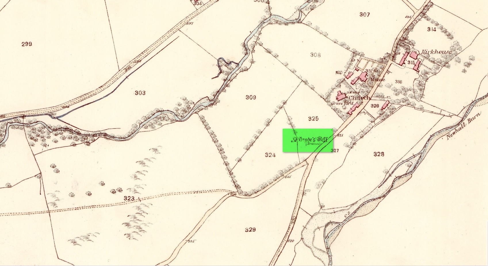
Site shown on 1858 map
Two hundred years ago, located halfway between Traquair’s present parish church and that of the demolished (apparently) 12th century church of St. Bride to the southwest, were the flowing waters of this once sacred water source. But it’s long since been destroyed. It was drained sometime prior to when the Ordnance Survey lads came here in 1856 and its water taken to supply the nearby manse. Subsequent surveys by the Royal Commission (1967) and Mr & Mrs Morris (1982) affirmed its demise. It was listed in the early Scottish holy well surveys, without comment, and I can find no local history accounts of the place.
References:
Hallen, A.W. Cornelius, “Holy Wells in Scotland,” in The Scottish Antiquary, volume 9, 1895.
Royal Commission on the Ancient & Historical Monuments, Scotland, Peeblesshire – volume 2, Aberdeen University Press 1967.
Walker, J. Russel, “‘Holy Wells’ in Scotland,” in Proceedings of the Society of Antiquaries of Scotland, volume 17,, 1883.
Acknowledgements:Huge thanks for use of the Ordnance Survey map in this site profile, reproduced with the kind permission of the National Library of Scotland.
Cup-Marked Stone (lost): OS Grid Reference – NT 3202 3347
Archaeology & History
In 1974, Ordnance Survey reported the existence of “a large piece of sandstone containing two depressions resembling cup marks” in the churchyard wall which, tradition told, originally came from the ruined 12th century parish church (long gone) more than 300 yards to the southwest (at NT 3185 3328). However, in recent years the cup-marks seem to have disappeared and may be hiding behind the overgrowth of ivy in the boundary wall. It needs to be recovered.
Halfway between the location of the original church and the present one, waters from the heathen St Bryde’s Well used to flow, but it had already been drained by 1856.
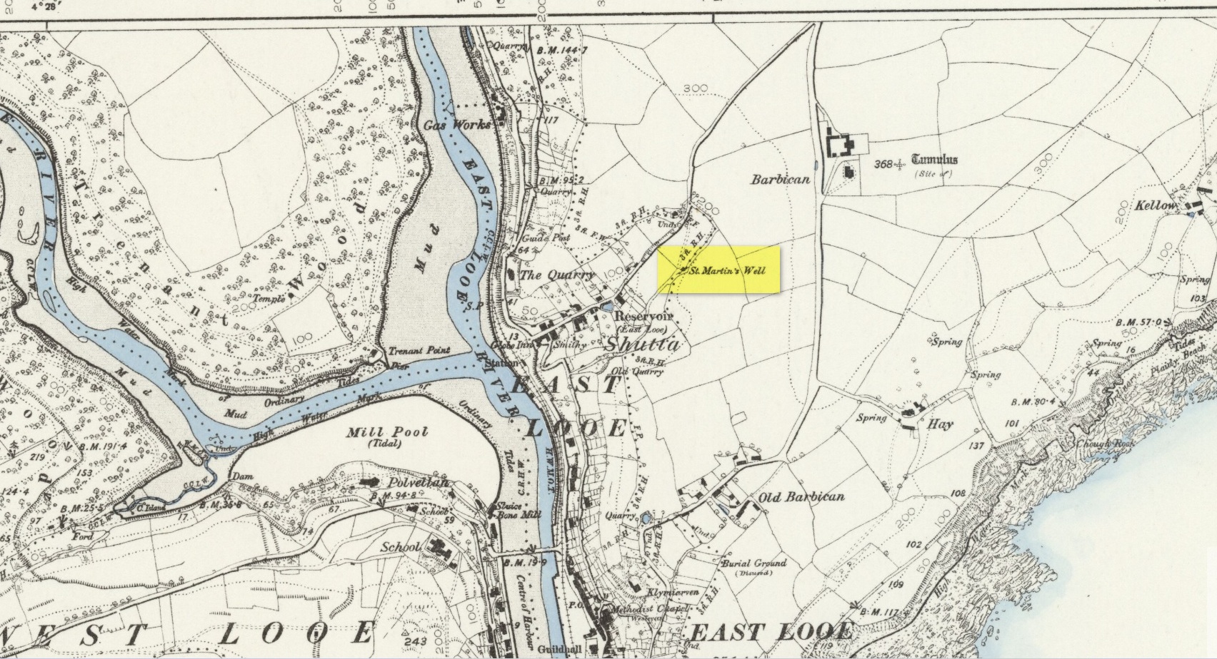
An early dedication to the St Martin of this well is from the 13th century, when referring to the “church of sanctus Martinus” in 1282, whose building is a half-mile to the north. The well itself is located on the old parish boundary, on the footpath today known as the North View.
In earlier days, the water from this site came “flowing out of a rock” giving birth to St Martin’s stream (Quiller-Couch, 1894). “It was much used by the villagers,” they wrote, “because of the excellent quality of the water; now it is covered in with an ordinary wooden lid, and is used to supply the town of Looe with water.”
Things hadn’t changed when Mr Lane-Davies (1970) visited the place, who was far from pleased at its status. “The spring,” he told, “has been enclosed in an ugly shed and the water piped away.”
Despite this, when Meyrick (1982) came here, he thought the site had “a romantic and grotto-like air” to it, but he was equally displeased by barbed wire preventing folk from easily accessing the waters and “spoilt by a certain amount of rubbish.” Unfortunately due to a dreadful accident here in 1993, when a young child fell into the waters and drowned, the site is now completely enclosed by railings to prevent this happening to anyone else.
References:
Bond, Thomas, Topographical and Historical Sketches of the Boroughs of East and West Looe, J. Nichols: London 1823.
Lane-Davies, A., Holy Wells of Cornwall, FOCS: St Ives 1970.
Meyrick, J., A Pilgrims Guide to the Holy Wells of Cornwall, Falmouth 1982.
Quiller-Couch, M. & L., Ancient and Holy Wells of Cornwall, C.J. Clark: London 1894.
Straffon, Cheryl, Fentynyow Kernow: In Search of Cornwall’s Holy Wells, Meyn Mamvro: Penzance 1998.
Legendary Rock (destroyed): OS Grid Reference – HP 5223 0467
Archaeology & History
Whilst classifying this as a “legendary” rock, it was as much a functional stone that played an integral part of local village life in the 19th century and, most probably, way before that. This large stone possessed a large cavity in the shape of a giant human footprint, measuring 12 inch by 4 inch. It could be seen “above the Deeks of Bracon, North Yell, up Hena”, but when first described in 1865, it was said to be “no longer in existence.” Despite this, when an Ordnance Survey dood came looking for it in 1969, he reported it as “still in existence” and known of by local people. Is there anyone in the far far north who can tell us?
Folklore
The impression of the large footprint was natural, but the use to which local people made of it is valuable when we seek to understand pre-industrial customs. The Royal Commission (1946) lads echoed the folklore handed down by J.T. Irvine from 1865, telling that,
“Formerly the people used to wash in dew or rain-water that had gathered in the cavity and stand in it to get rid of warts. The tradition was that a giant had planted one foot here and the other on a stone on the Westing of Unst.”
Healing stones with such properties can be found everywhere on Earth.
References:
Royal Commission Ancient & Historical Monuments, Scotland, Inventory of the Ancient Monuments of Orkney and Shetland – volume 3, HMSO: Edinburgh 1946.