Holy Well (destroyed): OS Grid Reference – SE 80528 42531
Also Known as:
St Everildis Well
Archaeology & History
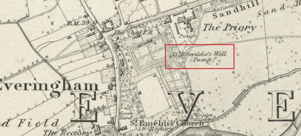
Shown on the 1855 Ordnance Survey map as a ‘pump’, in the grounds of Everingham Priory, the ‘seat’ of the lord of the manor, it was in an enclosure formerly open to the people of the village. It was filled in prior to 1923. The water was described as ‘abundant and excellent.’ Graeme Chapman, in his Yorkshire Holy Wells website states:
‘A few metres to the south of the site of the well the modern OS map marks the start of a stream (SE 8055 4250) which could be the original source of the Holy well’s water.’
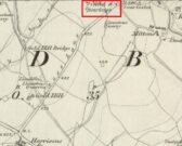
The well shown on the 1855 6″ OS Map.
The present writer has not been able to verify this from the materials available to him.
Everilda, also known as Everild and Averil, is recorded in the York Breviary, printed in 1493. She was a mid Yorkshire Saint who died around 700 CE. According to this source she was of a noble Wessex family who went to Yorkshire with companions Bega and Wulfreda, settling on land called Bishop’s Farm, an estate of the Bishop of York, St Wilfrid , which he gave to them, the place being then called Everildisham. There they established a nunnery, of which all trace is now lost. Her Saint’s day is July 9th. The name of St Everilda has been changed to ‘Emeldis’ in the dedication of the church at Everingham. Some historians claim the village is not named after her, but as a derivation of ‘ham of Eofor’s people’. The only other church known to be dedicated to her is at Nether Poppleton, some 17 miles north west of Everingham.
Folklore
The water of the village and the mothers of Everingham are said to have been blessed by St Everilda, and the Reverend Smith wrote that over a fifty year period, no mother had died in childbirth.
References:
Farmer, David, The Oxford Dictionary of Saints, Oxford University Press, Oxford, 1987
Raine, James, The Dedications of the Yorkshire Churches, The Yorkshire Archaeological and Topographical Journal, Vol II, 1873
Salisbury, Matthew Cheung, The Use of York: Characteristics of the Medieval Liturgical Office in York, Borthwick Institute, York, 2008
Smith, Rev William, Ancient Springs & Streams of the East Riding of Yorkshire, A.Brown & Sons, London, Hull & York, 1923
The site of the well, which was in the historic county of Middlesex, appears to have been on the west side of the present Moorefields Road just north of the junction with St Loy’s Road. The OS reference is an approximation. The restored circular well house to the south of the High Cross at the High Road – Philip Lane junction now popularly known as ‘The Old Well’ or ‘The Old Pump’ by Tottanham Green has been referred to as being ‘St Eloy’s Well’ but this is not the historic well described in this profile.
Archaeology & History
Likely position of the well on the 1873 6″ OS Map
The well was still in existence in 1876, but by the time of the revision of the OS map around 1894, it had been destroyed following building of the Great Eastern Railway’s Enfield branch line and the construction of terraced housing along the new St Loy’s Road.
So where was the well? The 1873 6″ OS map shows a field on parts of which the railway line and St Loy’s Road are now built, and a small area of water is shown in this field which is the likely position of St Loy’s Well on the eve of its destruction, when it was described as a dirty pool of water full of mud and rubbish. If this was the position of the well then it has now been completely built over…
It was described by Robinson in his 1841 History of Tottenham as being:
‘..in a field….on the western side of the High Road…surrounded by willows…it is bricked up on all sides, square and about 4 feet deep..’ ‘ In Bedwell’s time [it was]…always full of water, but never running over; the water of which is said to exceed all other near it.’.. ‘the properties of the water are similar to the water of the Cheltenham springs’.
Thomas Clay ‘s 1619 map of Tottenham, illustrated in Robinson’s book shows a field north west of Tottenham High Cross called ‘Southfeide at St Loys’. The Tottenham historian Wilhelm Bedwell described the well in 1631 as:
‘“nothing else but a deep pit in the highway, on the west side thereof;”….”it was within memory cleaned out, and at the bottom was found a fair great stone, which had certain letters or characters on it; but being broken or defaced by the negligence of the workmen, and nobody near that regarded such things, it was not known what they were or meant.’
This fair great stone with its ‘certain letters or characters that no one knew what they were or meant’ is intriguing especially in view of the well’s proximity to the Roman Ermine Street (Now the High Street). Were those mysterious characters spelling out an undecipherable Latin inscription on a Roman stone? We shall never know, but it hints at a pre-Christian origin or veneration of the well. Another hint is that before the Reformation there was nearby a chapel of St Eloy known as the Offertory*, which may have been originally built to ‘Christianise’ a pre-existing heathen sacred spring. The Roman origins of the well are also hinted at (probably erroneously) by W.L. Bowles in 1830, writing of a ‘Druidical Tour’ that one Sir Thomas Phillipps undertook on the continent, first quoting Phillipps before adding his own conclusion:
‘“Near Arras in France, are found the mount of St. Eloi and the very name of a place, Tote. I have no doubt Druidical remains will be found there, if this be not the very country of Carnutes.”
Now let me observe, that Tote is Taute —Tot—Thoth, latinized into Tewtates by Lucan, &c. the chief deity of the Celts. St. Eloi is neither more nor less than the Celtic word Sul, turned into the Greek the Sun; and Elios, turned into the Catholic St. Eloi, as at Tottenham, Middlesex, anciently Tote-ham, the ham of Taute or Tent, where is also the sacred well of St. Eloi, or ‘Helios’, the Sun !’
Saint Eloi / Eloy /Loy / Eligius, is the patron saint of those who work in the alchemists’ metal of the sun – goldsmiths! He is also the patron saint of blacksmiths, farriers, and all who earned their livings from horses, and lived from around 588 to 660 to become Bishop of Noyon and the evangelising apostle for much of modern day Belgium. His feast day is 1st December, and he had a widespread cult in mediaeval Europe, including England. In addition to being a healing well for humans, one writer hints that the well’s waters may have been employed for healing horses…they certainly would have drunk from it with its proximity to what is now the High Street.
Around 1770, an artist called Townsend (the sources are unsure as whether it was a Mrs or Mr) produced a romanticised drawing of the well, which was exhibited at the Royal Academy in 1770-1. It depicts a hermit beside the well (the Hermitage of St Anne stood to the south of High Cross prior to the Reformation) receiving an offering from a lady. It was engraved and sold as a print, and may be the only image of the well before its demise.
Folklore
In 1819 – 20, John Abraham Heraud wrote a poem about St Loy’s Well, set in the time of St. Edward the Martyr, (the late 970s), entitled ‘ Stanzas in the Legend of St Loy‘ of which the most relevant verses are;
‘TOTEHAM! the Legend of thine olden day, To the last note hath on thine echoes died; But the Bard’s soul still lingers o’er the lay, To muse upon thy transitory pride The pride of times that hath been — blank and void— When all was Nature, big with many a song Of Chivalry and Fame, with Love allied— But Time both changed the scene — now houses throng Where once was solitude — and people crowd along.
Where now thy WOOD, that spread its misty shade O’er twice two hundred acres? — past away! And vain its PROVERB, as the things that fade, Earth, sun, moon, stars, that change as they decay! The lonely CELL, the tenor of the lay, Its grove, which hermit tendance loved to rear; And, St. LOY, mouldering to Time’s gradual sway, Thy rites, thy OFFERTORY disappear;— Forgot thy SPRING OF HEALTH no votary worships there!
Forgot, neglected — still my harp shall dwell On thee, thou blest BETHESDA of ST. LOY! As Fancy muses o’er the vital WELL On years of storied yore, with grief and joy, Exults they were — weeps Truth should e’er destroy! Thrice I invoke the Spirit of the Stream With charm she may not question, or deny, And, like a Naiad, o’er the watery gleam She rises to my voice, and answers thus the theme:— ‘
Heraud wrote a further poem mentioning the well, his ‘Tottenham‘ of 1820, the relevant verse being:
‘St. Loy! here is this fountain—emblem pure Of chaste unostentatious charity— Never in vain intreated, ever sure ; Yet o’er the marge thy waters fair and free Ascend not, overflowing vauntingly, But in thy bounty humble as unfailing, In grief, disease, and sickness, visit thee. But part in joy, changed by thy holy healing To manhood, strength, and life, thy far renown revealing. There is thy offertory, and thy shrine, Simple, inartificial ; nor of fame, Nor any honour, save that it is thine, And all its glory centres in thy name !’
*Footnote – Brian Spencer’s book on mediaeval pigrim badges recovered by archaeologists in London refers (p222) to a distinct ‘London pattern’ of St Eloi badge – is this a hint that the Offertory was a local shrine to St Eloi where such badges were sold to pilgrims? Further research is needed to try to verify this speculation.
Take the Glenfarg road out of Bridge of Earn, cross the motorway and park at the layby past the bend. Go through the gate opposite and follow the track up to the telecoms mast, you can’t miss it..
Archaeology & History
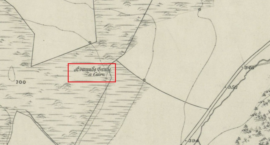
Shown on the 1866 OS Map
Visible from the lowlands below, it is described in the official listing as a cairn of prehistoric date, a funerary monument dating to the late neolithic to early Bronze Age. It is a broadly round stony mound, partially overgrown with turf on the north eastern (mid-summer sunrise) slope of Balmanno Hill, where it has extensive views over the surrounding country. It is 1.8m (6′) high, 17m (56′) across on the N-S axis and 16m (52′ ) on the E-W axis.
The top of the cairn has a depression in it: possibly the result of treasure-seeking long ago, but there is no evidence of any burial cist.
So who was ‘Edmund’? Was this a place of heathen ritual Christianised with the designation of St Edmund during the Anglo-Saxon incursions of the early middle ages, or the name of a local landowner? It is lost to history. The name ‘Balmanno’ can be interpreted as ‘Place of the Big Man’ – so have we an echo of a lost giant legend here in an area of Scotland where such legends abound, and long pre-date the construction of the cairn? Did later people name their local mythic giant ‘Edmund’?
An alternative meaning of ‘Balmanno’ is given by David Dow in the Old Statistical Account – the ‘Town of the Monk’.
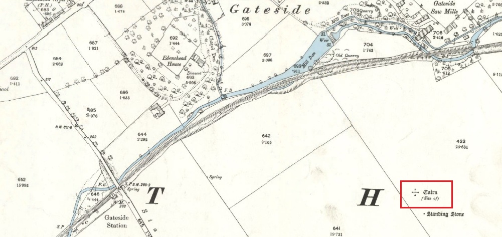
The easiest way is to turn south off the A91 at Gateside onto Station Road, and the site of the cairn is in the third field to the left over the railway bridge. I accessed the site walking along the old railway line and climbing up the embankment.
Archaeology & History
The site of the Cairn on the 1894 25 in. OS map.
In the shadow of the Lomond Hills of Fife, what was once a very large pre-historic cairn, officially described as of ‘unassigned’ period, was quarried to destruction around two hundred and twenty years ago, presumably to provide stones for dykes (stone walls), at that time of enclosures of common land and what the landowners liked to call ‘agricultural improvements’.
In the early nineteenth century, this part of the Eden Valley between Gateside and the Lomond Hills was what would now be called a ritual landscape. There were, according to Miller:
‘nearly in a line between the two Laws ( Lomond Hills) noless than eight “druidical temples” (Stone circles) close together‘
and a number of impressive burial cairns, of which Easter Nether Urquhart seems to have been the largest. There were in addition large numbers of graves containing masses of cremated of human bones. Nearly all this archaeology has been subsequently destroyed by the farmers.
Two local antiquarian writers proposed that all these human remains had been buried there following the battle of Mons Graupius between the Roman Invaders under Agricola, and the Caledonians, and went on to argue that the Eden Valley was the site of this historic defeat for the ancient Caledonians defending their homeland. Whatever and whenever the origins of the cairns and human remains, subsequent researchers disagree with these nineteenth century arguments in favour of the Eden Valley, and tend to favour a more northerly location for Mons Graupius. Nevertheless we have these two historians to thank for leaving us descriptions of the cairn.
One of the antiquarians, Rev. Andrew Small wrote in 1823:
‘The Slaughter here seems to have been so dreadful, that even after the lapse of 17 Centuries the Common tradition of the Country bears, and seems to be as fresh in the Mouths of both old and young as though the battle had been fought only a hundred years ago, – that after this battle the River Eden ran red with blood for two days…’
It seems more likely that the event remembered was part of the campaign by Roman Emperor Septimus Severus and his son Caracalla to subdue the Caledonians around 209-210 CE. Modern writer, Simon Elliott:
‘Archaeological data is now emerging to show ….. a major depopulation event, indicating something close to a genocide was committed by the Romans in the central and upper Midland Valley.’
Andrew Small describing the cairn and some of the cremation remains in 1823:
‘There was also a very large cairn laid upon these ; and the proprietor lately told me that when removing the stones, besides the ashes already mentioned, there was also a pit of pure fine sand by itself, about as fine as is usually put into sand-glasses, which he thinks had been used for regulating the fire in burning of the dead. This cairn stood a little north of an ancient Druids temple, only one stone now remaining, out of ten of which it formerly consisted ‘.
Lieutenant – Colonel, Miller writing in 1829:
‘Farther west ….a very large cairn stood, containing upwards of two thousand cart-loads of stones. Upon removing it about thirty years ago, a pit six feet long, two broad, and of the same depth, was found, quite full of burnt bones; and near it another, two feet square and two deep, full of the finest sand. An urn was also found, near the surface of the cairn, full of bones. A very fine Druid’s temple stood on the south side of it, consisting of seven very large stones…’
As the builders of the cairn didn’t have access to carts, and that the stones all had to be moved by hand, it gives an indication of the manpower needed to build the cairn, and the status of the individuals whose remains were buried there. And we have to question why a special chamber been built into the base of the cairn to hold fine sand, and what was the purpose of this sand?
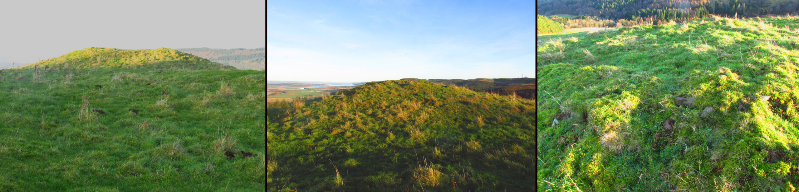
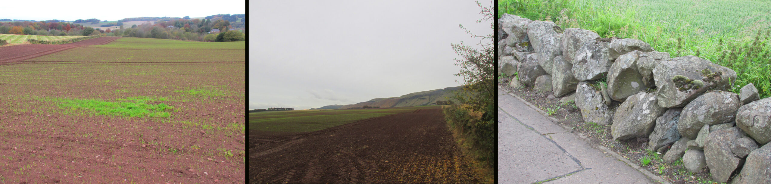
Left – View of Cairn site looking north, centre of the field beyond the tractor tracks. Centre – View looking south. Right – The cairn recycled? Walling on the south side of A91 at Gateside
Folklore
While not writing specifically of the cairn, Revd. Small recounts these tales of the surrounding land, relating it to his belief that it was the site of Mons Graupius:
‘I cannot forbear to mention here, also, a singular circumstance I had from the landlord and landlady, both yet alive, — viz. that before parking or inclosing took place, they were accustomed to have folds built of feal or turf for the cattle lying in at night ; but that, when the folds happened to be in this place where the dead had been burnt, the cattle would never lie in them, but always broke through or leaped over the dyke ; that they were obliged to give a man a boll of barley extra to watch them, when they lay in this spot, which was obliged to be repeated every four or five years in rotation ; but that sometimes the man was not able to keep them in by all his endeavours, the cattle looking wild and terrified in appearance ; and sometimes it required the united efforts of all the hands that could be had to keep them in, oftentimes springing over the fold dykes close beside them, and frequently crouching and trembling as if they would have fallen down with terror, although nothing appeared visible to the visual organs either of the man or those that occasionally assisted him. However, after the discovery of so many ashes and fragments of human bones, the man declared that, had he known of these being so near, he would not have been so fond of watching.’
‘The late farmer of Upper Orquart, a most respectable man, with whom I was well acquainted, and upon whose farm the principal part of the battle was fought, told me also that always when the folds happened to be both at where the Caledonians were burnt as well as the Romans — but particularly he specified the spot where the Romans had been burnt, or the Witch Know or Knoll — the cattle would never lie in the fold, but were always breaking ” the fauld,” as he called it, except when they were particularly watched ; and even that was not always effectual for keeping them from doing it either. This would insinuate as if the spirits of these departed heroes of antiquity sometimes visited and hovered about the places where their ashes had been deposited ; though invisible to the more refined visual organs of the human eye, yet obviously visible in some shape or other to the more gross visual organs of the irrational or bestial tribe, else how can these forementioned occurrences be accounted for? This hypothesis seems to be borne out by Balaam’s Ass perceiving the Angel twice, when he himself could not do so till his eyes were supernaturally opened.’
Afterword
Although the cairn no longer exists, its stones were probably reused for local walling, and it’s likely, but not provable, that the wall on the south side of the A91 past the Station Road turning is built from stones removed from the cairn.
References:
Elliott, Simon, Septimus Severus in Scotland, Greenhill Books, 2018.
Miller, Lt. Col., “An Inquiry Respecting the Site of theBattle of Mons Grampius“, 1829, published in Archaeologica Scotica vol. IV, 1857.
Small, Andrew, Interesting Roman Antiquities Recently Discovered in Fife, John Anderson, Edinburgh, 1823
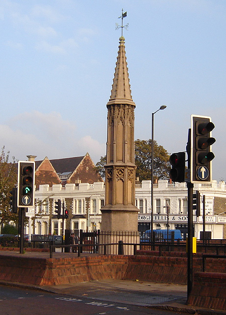
The Cross is on the east side of the A10 Tottenham High Road, on the traffic island at the Monument Way Junction.
Archaeology & History
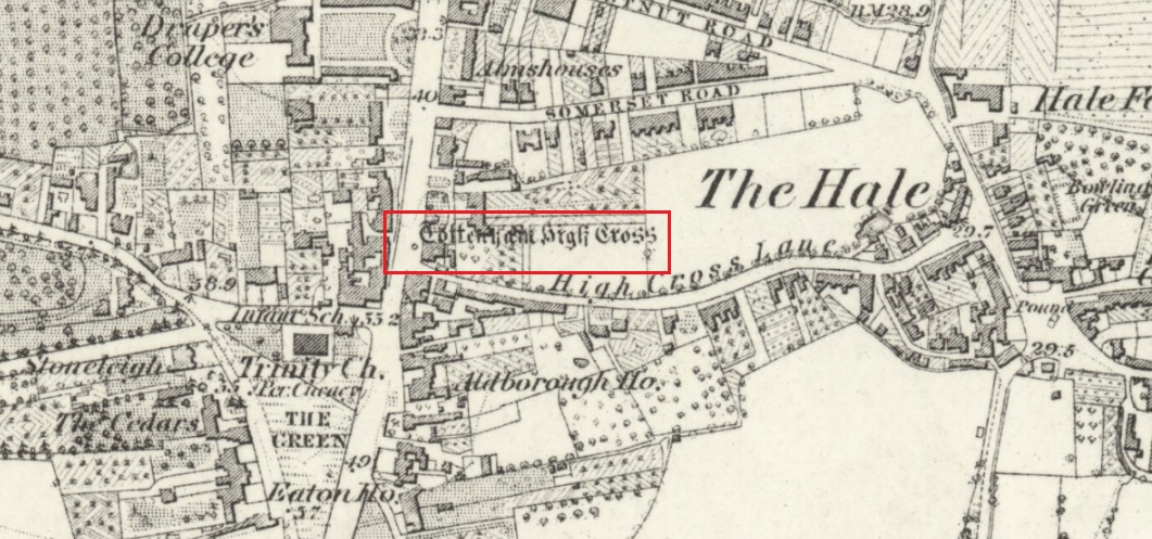
Cross shown on 1873 map
One of the earliest records of what was called the “hie crosse” is contained in a court-roll of 1456. It was at that time a wooden wayside cross, but there are hints that its origins may go back to Roman times. The Cross is next to what was the southern end of Ermine Street, built by the Romans where there was no pre-existing roadway and described as the most important thoroughfare in Britain: built to give direct communication to the main centres of the military occupation at Lincoln and York. Writing of Roman land survey marks, the now discredited early 20th century Middlesex historian Sir Montagu Sharpe (1932) thought Tottenham Cross possibly marked an earlier (i.e. Roman) stone, although no archaeological evidence has been found to support this. As it was next to Ermine Street it could equally have been a milestone or ceremonial pillar. After the Romans left it may have become a local heathen shrine which, with the coming of Christianity, was ultimately replaced by a wooden cross—but this is speculation, and we will probably never know why and when the original cross was placed where it was.
Originally in the historic County of Middlesex, the settlement of Tottenham surrounding the Cross was known from mediaeval times to the 19th century as ‘Tottenham High Cross’. Local historian William Robinson writing prior to 1840 thus describes the Cross:
“About the year 1580, a column of wood was standing, with a square sheet of lead on the top to throw off the water, supported by four spurs: these, being decayed and rotten, were taken down, about the year 1600, by Dean Wood, Dean of Armagh, who at that time resided in a house on the east side of it, and who erected on its site an octangular brick column, pointed at the top and crowned with a weathercock, and the initials of the four cardinal points, and under the neckings, small crosses, which were called tau-crosses, according to the true cross or Greek letter T.
“Tottenham High Cross, as it appeared in 1788, was an octangular brick pillar, divided into four stories, viz.: a double plinth, first portion of the pillar; second portion, of the same; and a pinnacle; each plinth and story rendered distinct one from the other by certain appropriate mouldings ; and the whole design appeared without any kind of ornament, pointed at the top and crowned with a weathercock. The Cross having fallen into decay, several of the inhabitants of the parish entered into a subscription, in the year 1809, for the purpose of putting it into a proper state of repair, and about the sum of £300. was raised. It was accordingly repaired, and covered with Parker’s cement. The octangular plan, and the proportions of the Cross in its four stories, have not been departed from ; but in other respects it is a new work ; some of the decorations seem to be formed from the exterior and interior of the chapel of Henry VIII; the double plinths or pedestals are as plain as before, but the intermediate mouldings are new; the first portion of the pillar consists of angular pilasters at each cant done with a pointed head; compartment of five turns, connecting itself with another compartment; above it diamonded, with a shield containing an imitation of the black letter. As there are eight faces to the upright, of course there are as many shields, each bearing a letter of the same cutting, beginning at the west face, TOTENHAM: in consequence of there being but eight shields, one of the T’s in the spelling has been necessarily dispensed with. The mouldings between this story and the second are worked into an entablature, with modern fancy heads and small pieces of ornaments alternately set at each angle.
“Second story—small buttresses at the angles of the octagon, with breaks and pinnacles, but no bases. The face of each cant has a compartment embellished with an ogee head, backed with narrow pointed compartments. The mouldings between this story and the pinnacle, making out a fourth story, give, at each angle, crockets, and its termination is with a double finial, but not set out in geometrical rule to the crockets below : there is at the top a vane, with N. E. W. S. The base is surrounded with a neat iron railing on Portland stone curb. The date at which these alterations were made is not placed in any conspicuous part of the structure.”
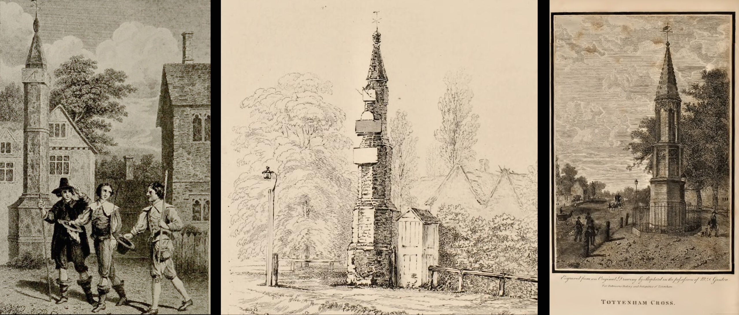
(left) engraving based on Samuel Wale’s 1759 illustration to Compleat Angler; (centre & right) 19th C views pre- and post-renovation
The craftsman who carried out the modernisation was a Mr. Bernasconia, working to the designs of a Mr. Shaw. Not everyone was pleased by the transformation. A regular contributor identified only as ‘An Architect’ made these caustic comments in the November 1809 edition of the Gentleman’s Magazine:
“Tottenham High Cross has this summer been covered over with Compo: it previously bore a simple appearance, but is now rendered of a very rich and elaborate cast, doing away in the first instance the Architectural history of the erection; and allowing it possible that there might once have been on the spot an Eleanora Cross, holding in contempt, by a want of due imitation, the characteristic style of decoration prevailed at at the time of the Queen’s demise. But according to the system of our Professional innovators, to destroy a sacred relick of antiquity, and to restore it as it is called, upon a model quite in a different style and nature, is one and the same thing. “Any thing is Gothick.”
“….Surveyed November 1809. Entirely covered with the proclaimed everlasting stuff, Compo; a stuff now the rage for trowelling over our new buildings, either on the whole surface, or in partial daubings and patchings; it is used in common with stone work, for instance, on an arcade, half one material, half the other; “ making good,” as it is called (abominable expedient) the mutilated parts of Antient Structures, there sticking on until it reverts (after exposure to the air for three or four years, more or less) to its first quality, dirt and rubbish, and then is seen no more….
“Provided this Compo effort had been advanced on any other occasion, and on any other piece of ground, where no piece of Antiquity was to become the spoil, such as an object to mark the centrical point of three or four counties, a general standard of miles or any other common document for the information or amusement of travellers, all would have been well, and some praise might have been bestowed, for its tolerable adherence to the above style, if not for the material wherewith it is made up. But as nothing of this sort will come in aid of the innovators, and only the barefaced presumption, “ alter or destroy, what was,” is to be encountered, let the detail of parts, put this matter to issue….”
Folklore
A modern view (Wikipedia Creative Commons)
The Cross stood in front of the Swan Inn, a place frequented by fishing writer Izaak Walton in the 1640s when he would go to fish in the nearby River Lea. In 1653 he published The Compleat Angler describing his fishing activities in the classical form of a philosophical dialogue between him as ‘Piscator’ and ‘Venator’ (hunter) and other passing characters, starting and ending his adventures at the High Cross. The 1759 edition of Compleat Angler contains the earliest illustrations of the Cross, with some slight artistic licence, by Samuel Wale.
Afterword
As the Cross now stands in the maelstrom of North London’s traffic, it is worth recalling American traveller Nathaniel Carter’s 1825 observation when travelling north from London:
“Passing Tottenham Cross, we entered a rich agricultural country, possessing the usual charms of English landscape.”
References:
An Architect (pseud.) – Architectural Innovation No. CXXXIX – The Gentleman’s Magazine, November 1809
Anonymous – Tottenham High Cross, The Gentleman’s Magazine, April 1820
Blair, John, The Church in Anglo Saxon Society, Oxford University Press 2005
Carter, Nathaniel Hazeltine, Letters From Europe..in 1825 ’26 & ’27, G & C & H Carvill, New York, 1829
Margary, Ivan D., Roman Roads in Britain, 3rd Ed., John Baker: London 1973.
Robinson, William, The History & Antiquities of the Parish of Tottenham, 2nd Ed., Nicholls & Son, W. Pickering, W.B. Hunnings: London 1840.
Sharpe, Montagu, Middlesex in British, Roman & Saxon Times, 2nd Ed., Methuen: London 1932.
Walton, Izaak, The Compleat Angler, Facsimile of the 1st Ed., containing illustrations from the 2nd US edition by John Major, No imprimatur, 1907.
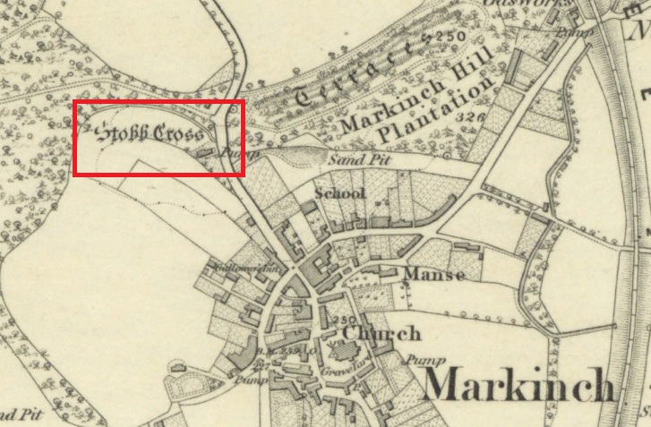
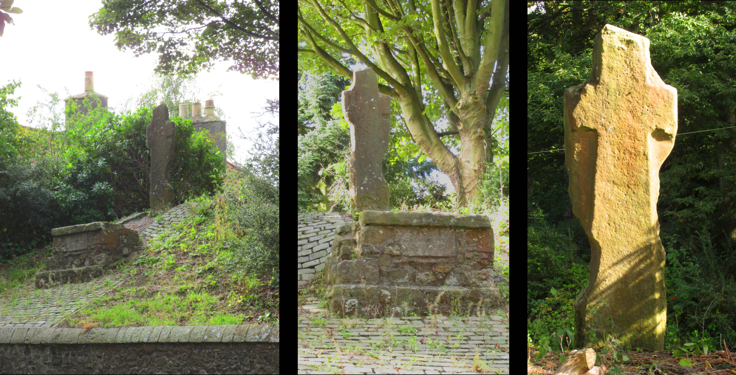
The cross is located on a bluff of land overlooking the west side of Stob Cross Road on the northern edge of Markinch.
Archaeology & History
In 1933, following a visit in 1925, the county archaeological inventory described it thus:-
Close beside the East Lodge of Balbirnie House, on a knoll 200 feet above sea-level, stands a stone known, from the nature of its sculpturings, as the “Stob Cross.” It is a somewhat mutilated rectangular slab, 7 feet 5 ½ inches in height, 2 feet broad at the base and 6 inches thick, having a plain cross carved in relief on the east and on the west face. The cross on the east is now very much damaged but sufficient remains to indicate that the arms have been 1 foot wide and that the shaft has measured 1 foot 5 inches across at the intersection. On the west face the design stands out in relief from 1 to 1 ¼ inches. The arms of the cross measure 11 ½ inches in width, and the upper limb, which tapers slightly to its extremity, is 12 ½ inches across at the point of intersection. The shaft measures 1 foot 2 inches across below the arms and widens gradually downwards to 1 foot 8 inches at the base. In 1790, when the cross was in danger of falling, the Earl of Leven had the position faced up with masonry, and the monument now stands, with its major axis north and south, on a two-stepped base of modern construction.
Roadside views l. & centre – Rear view r.
It’s certainly had a hard life, and its official designation as ‘early medieval’ leads us to suspect that it may have been a decorated Pictish cross that has had its ornamentation obliterated by Reformation iconoclasts. Those same iconoclasts may have concocted the ‘history’ recounted by Rev John Thomson (1794) in the Old Statistical Account of 1794 of what he describes as a ‘very coarse piece of work’:-
‘Vulgar tradition says, that it was erected to the memory of a gentleman, who fell on this spot, in a mortal encounter with one of his neighbours.’
Writing of Markinch, nineteenth century historian Aeneas Mackay (1896) has this to say:-
‘A cell of the Culdees was established there by one of the last Celtic bishops, and the ancient cross near Balgonie [sic] may mark its site.’
Modern place-name research ascribes Markinch as a place where horses were grazed while their owners were attending the early mediaeval courts and assemblies at Dalginch a quarter of a mile to the east, so the cross may at that time have been a waymarker. A roadside plaque describes the Cross as possibly marking the limit of an ancient sanctuary enclosure related to the church of St Drostan (known locally as St. Modrustus) in the centre of Markinch. Additionally, it was on the ancient (and recently revived) Fife Pilgrim Way from Culross to St Andrews, so would have been a wayside station for the pilgrims. which if it was a Pictish cross would have made it a target for desecration by iconoclasts. We are lucky that it has survived at all, and with the revival of the Pilgrim Way as a long distance path it will attract many new admirers.
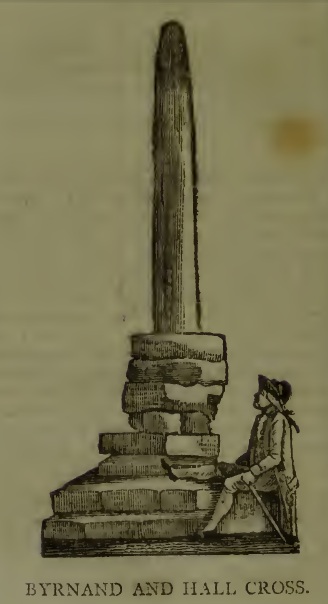
This long lost Cross could once be seen close to the Tudor era Byrnand Hall, which stood on the north side of the High Street. The Hall was demolished around 1780, and replaced by the present building, which is now a political club. The Cross was taken down around the same time, so we’re very fortunate to have a contemporary sketch.
Harry Speight (1906), the Great Yorkshire antiquarian, described the Cross when he was writing of the ‘big houses’ of Knaresborough, saying:
“Another notable old mansion was Byrnand Hall, which stood at the top of the High Street facing Gracious Street, and was rebuilt about a century ago. It was the property and seat for many generations of one of the leading families of Knaresborough, named Byrnand, one of its members being recorder of York in 1573. Opposite the house stood a very ancient stone cross, consisting of a plain upright column, without date or inscription, supported by several rudely-formed stones placed on three tiers or steps. It appears that one Richard Byrnand paid a fine and was permitted to enclose a cross standing on a piece of waste land then lately belonging to Robert Nessfield. The cross may be conjectured to have been either a memorial or boundary-stone. In those days ” it was not enough,” says the old antiquary, Hearne, ” to have the figure of the cross both on and in churches, chapels, and oratories, but it was put also in church-yards, and in every house, nay, many towns and villages were built in shape of it, and it was very common to fix it in the very streets and highways.
“This ancient relic, the site of which is now marked by a brass cross sunk in the causeway, was in after times called the Byrnand Hall Cross, from its proximity to the house of the same name. It stands on the road equidistant between York and Leeds, being eighteen miles from either place.”
At the end of the eighteenth century, E. Hargrove wrote:
“The (Byrnand) family mansion was situated at the end of the High-street, leading towards York. Near it formerly stood an ancient Cross, which being placed on the outside of the Rampart, and opposite to the entrance into the borough, seems to have been similar in situation, and probably may have been used for the same purpose, as that mentioned by Mr. Pennant, in his History of London, which stood without the city, opposite to Chester Inn; and here, according to the simplicity of the age, in the year 1294, and at other times, the magistrates sat to administer justice. Byrnand-Hall hath been lately rebuilt, by Mr. William Manby, who took down the remains of the old Cross, and left a cruciform stone in the pavement, which will mark the place to future times.”
Abbot J.I. Cummins, writing in the 1920s about the Catholic history of Knaresborough, told:
“Of the Byrnand Cross beyond the old town ditch the site is now marked in York Place by a brass cross let into the pavement for Christians to trample on.”
The Cross occupied an important position in the Knaresborough of old, at one of the highest points of the town by the junction of the modern High Street and Gracious Street, this latter being the road down the hill to the riverside and the troglodytic shrines of St Robert of Knaresborough and Our Lady.
Assuming the eighteenth century drawing is an accurate representation of the Cross, it does give the impression of considerable antiquity, and looks to have been 15-16 feet (4.75m.) high. From its appearance it looks like either a prehistoric monolith or an Anglo-Saxon ‘stapol‘ or column, and if it was the latter, it may have been erected to replace an earlier heathen wooden column or sacred tree following the replacement of the old beliefs by Christianity. If so, there may be no reason to deny Hargrove’s speculation that Byrnand Hall Cross once had a similar juridical function to the Chester Inn Cross in London.
References:
Bintley, Michael D.J., Trees in the Religions of Early Medieval England, Woodbridge, Suffolk, Boydell Press 2015.
Cummins, J.I., “Knaresborough,” in The Ampleforth Journal, Vol XXIV, No II, Spring 1929.
Hargrove, E., The History of the Castle, Town and Forest of Knaresborough, 5th Edition, Knaresborough 1790.
Speight, H., Nidderdale, from Nun Monkton to Whernside, London, Elliot Stock, 1906.
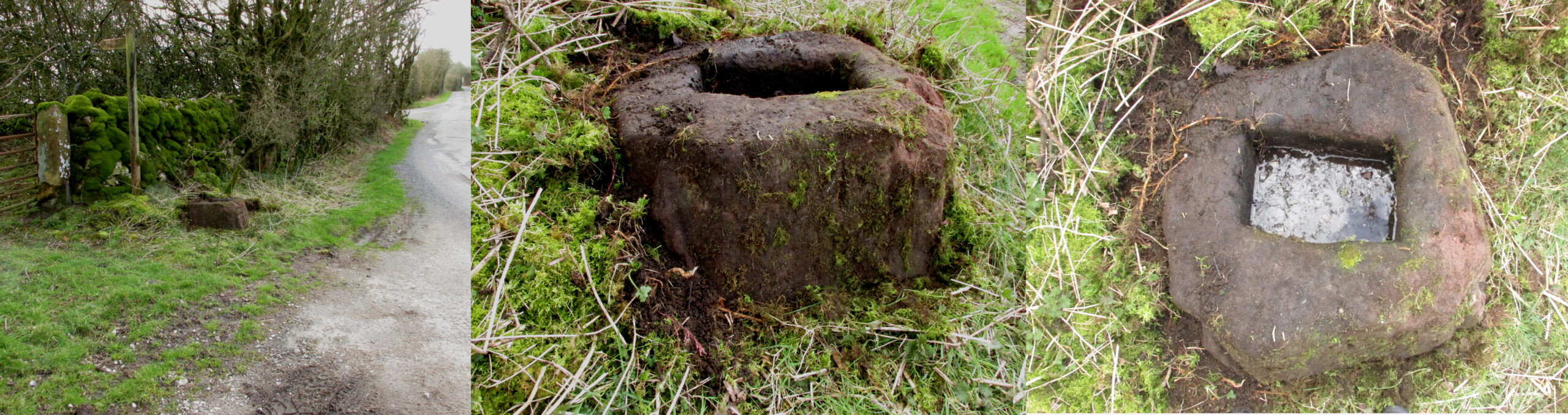
Take the Town End Road out of Slaidburn, and turn right along Wood House Lane at the Gold Hill junction, continue past the entrance to Myttons Farm on the right, and the cross base will be seen on the right next to the gateway just before the sharp left hand bend.
Archaeology & History
Only the socketed red sandstone base of this mediaeval wayside cross survives. It is unusual in that it has carved decorative fluted corners. It has an OS bench mark carved on its north face and has suffered recent damage to one of the corners, probably from a grass cutter. It is beside the old salt road over Salter Fell from Bowland into Lancashire and the Lune Valley.
There is one surviving complete cross and a cross base at the other end of the salt road, south of Hornby. Wood House Lane was known as Cross Lane when the 1850 6″ OS map was printed. It is a Grade II listed building and is described in the citation as:
“Base of cross, probably medieval, sandstone. Of irregular shape with a rectangular socket in the top.”
Three views of the Cross base
Folklore
The farmer of the adjoining land told me that a local elder had told him that the smashed remains of the Cross had been built into an adjoining dry stone wall, which, if this is correct, may indicate
destruction of the Cross at a comparatively late date.
Note: the monument is in the historic county of the West Riding of Yorkshire.
Take the road to Auchlyne from Killin which follows the north side of the River Dochart, and on the edge of the village the stone will be seen on the left hand side behind a hedge, opposite the entrance to ‘Springburn’.
Archaeology & History
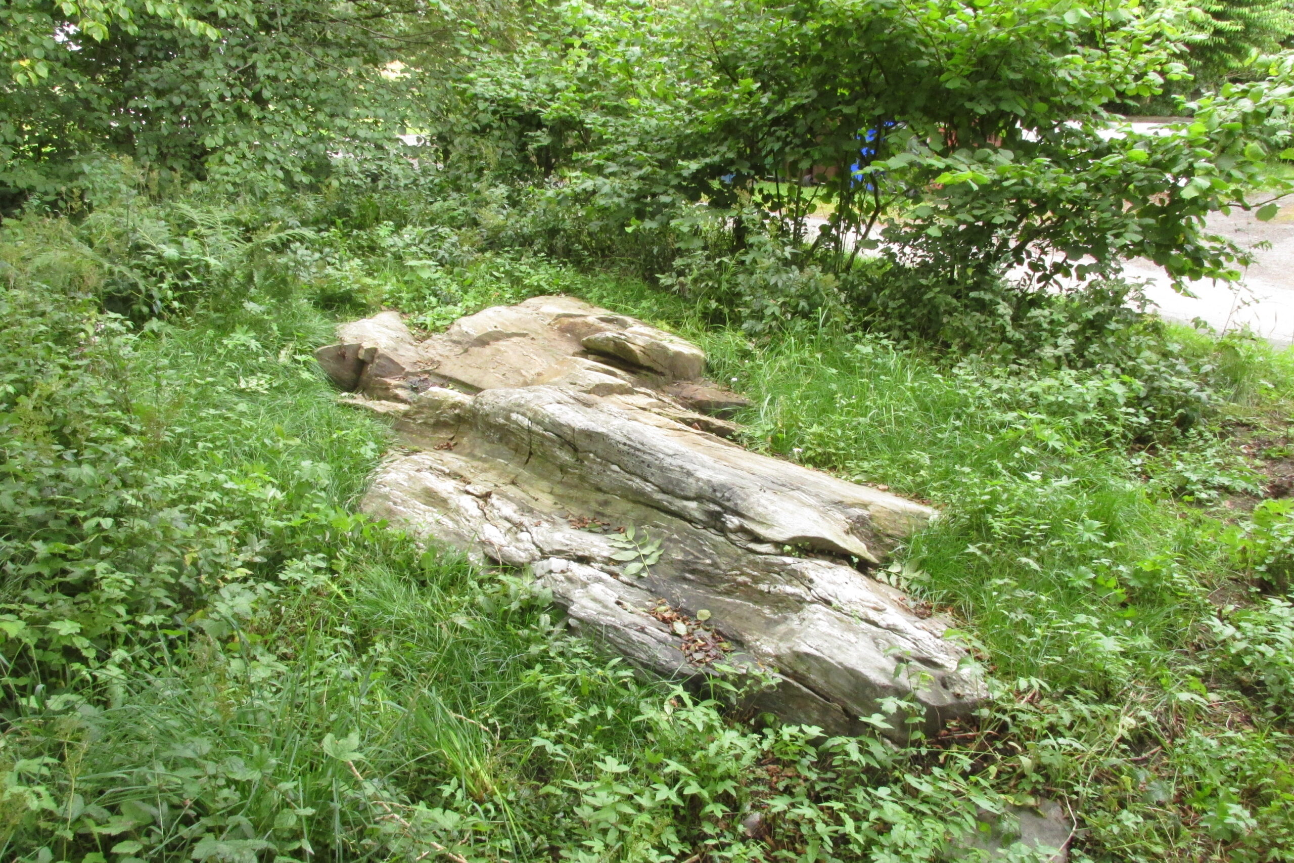
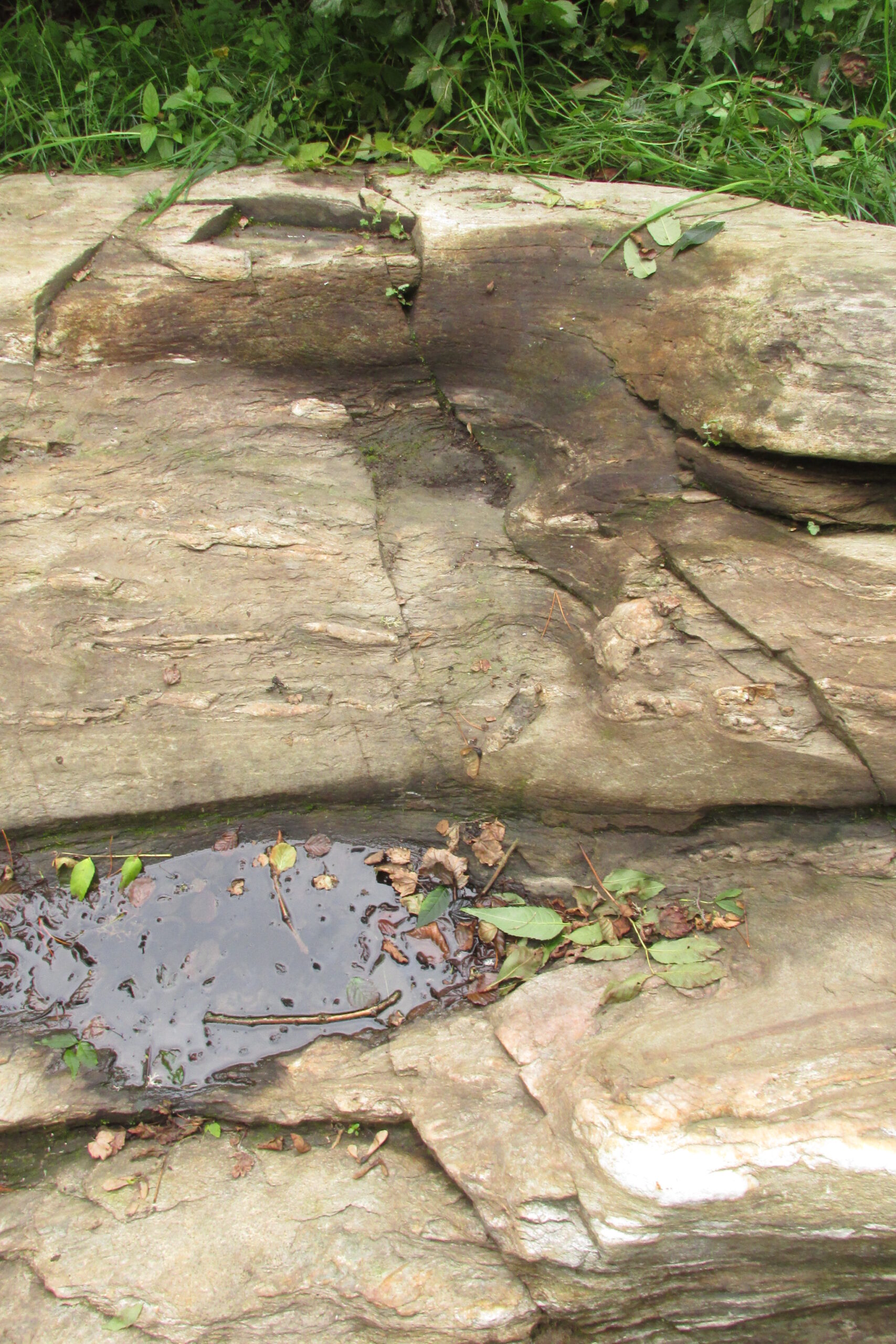
The chair is mentioned in Rev. Gillies’ exemplary work, In Famed Breadalbane (1938):
‘St. Fillan would appear to have had a great liking for stone seats. Besides the one already mentioned…there is..a..flat stone on the top of a knoll about a mile to the west of the village, and on the north side of the river, on which he is said to have sat and taught‘
St Fillan’s Chair, ‘twixt road and riverThe ‘seat’, facing the River Dochart
Two local ladies told us that the Chair had recently been uncovered from the vegetation. It is a flattish earth-fast slab of rock, which has on the right hand side a seat indentation, which faces the river bank about 12 feet away. Its proximity to the river bank would seem to limit its use as a preaching pulpit, and yet, well over a millennium after the death of Fillan, his ‘Chair’ is still remembered. Did the Chair serve another purpose, a purpose that long preceded Fillan and Christianity?
Here at Killin we are in an area of Scotland where Christianity was for long a veil worn very lightly over long-held ancient animistic beliefs and customs. Indeed in the early nineteenth century, missionaries were sent in the face of considerable local opposition by the Haldanes into Gaelic speaking Breadalbane to try to convert the locals to Christianity.
St Fillan and other saints had it seems become the named facilitators for healing at ancient places on behalf of the incoming religion from the Middle East. To the west of Killin, there are the St Fillan’s Pools at Auchtertyre near Tyndrum, where he is reputed to have cured madness but which continued to be used for that purpose until the late eighteenth century at least. There are stones for preventing measles and whooping cough near Killin that are still known and pointed out. So what of our chair?
There is a nineteenth century story of a chair of St Fiacre (Irish born like Fillan) at the village church of St Fiacre near Monceaux in France being used to ‘confer fecundity upon women who sit upon it ‘. The shape and proximity to the river may otherwise suggest St Fillan’s Chair was a birthing Chair? Maybe some very old locals still know the true story of this Chair, but would they tell it?
References:
Anon., Phallic Worship – a Description of the Mysteries of the Sex Worship of the Ancients, privately Printed: London 1880.
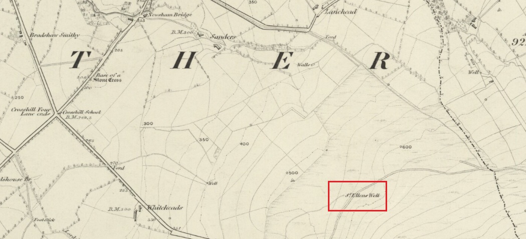
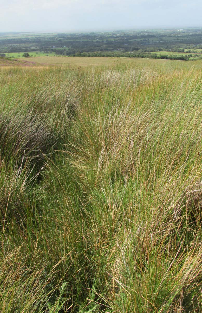
Approaching the site from the north, walk along the Lane Head track, and along the path south-eastwards, then turn right onto the main footpath until coming to the stream. Follow the stream up the fell to the large clump of reeds, then follow your ears until you locate the spring! Or you can approach it along the main footpath from the Oakenclough – Galgate road. The well and the path to it
are on access land.
Archaeology & History
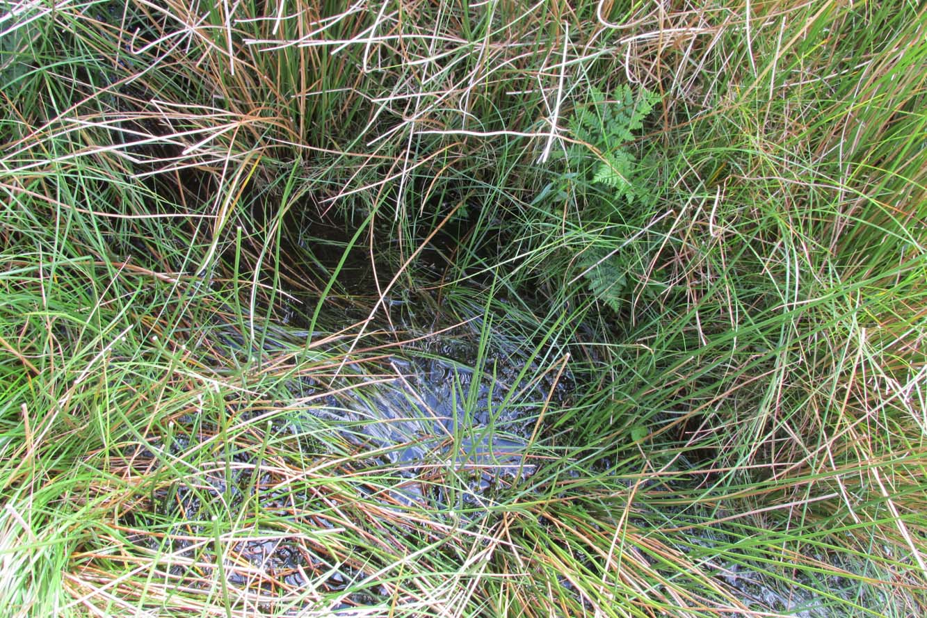
Fortunately recorded by the Ordnance Survey on their 1846 6″ map Lancashire XL, the story of St Ellen’s Well was taken up sixty years later by local holy wells historian Henry Taylor (1906):
Listen for the spring in the reeds
“The site of this holy well is marked on the ordnance map at a lonely spot on Harris Fell, five hundred feet above the sea-level, four and a half miles in a north-easterly direction from the town of Garstang.
“Mr. A. King has kindly examined the site. He writes, 4th August, 1902: “We had no difficulty in locating the spot…. There is no outward indication of the place being used for curative means, and there is no stonework at all. It is a beautifully cold spring which is at the side of ‘Bonny Pad’, a pathway leading across the moor from Harris End, and it was grown around with rushes…. All I can glean about it is that one of the oldest inhabitants, when asked if he knew of it, replied, ‘It will be th’ holy well, you mean.'”
The original dedication of this remote holy well was clearly to St. Helen, and its presence next to the Bonny Pad or path may indicate a pre-Christian dedication to a local cognate of the Celtic Elen Luyddog, Elen of the hosts or ways. The Bonny Pad is shown but not not named on the 1846 map, and follows a broadly southwest to northeast direction from Harris End (again not named on the 1846 map) up to Grizedale Head on the southern edge of the Catshaw Vaccary. It was perhaps an ancient route used by farmers to take their animals up onto the fell for the summer, and return them to the lowlands in the autumn.
Bubbling away at source
The western portion of Bonny Pad is not shown on the modern map and St Ellen’s Well is not marked, and both have it seems passed out of local memory. An elderly farmer I encountered on my way up to the fell had never heard of the Well.
It is certainly worth the walk if only for the delightful sound of this powerfully flowing spring, the water is pure and cold, and it commands a fine view over the Lancashire plain to the coast.
References:
Taylor, Henry, The Ancient Crosses and Holy Wells of Lancashire, Sherratt & Hughes: Manchester 1906.
Wise, Caroline, “Elen of the Roads of Country and Town”, in Finding Elen – The Quest for Elen of the Ways, edited by Caroline Wise, Eala Press: London 2015.