Witches Stones, Kirkton of Auchterhouse, Angus

Cup-and-Ring Stones (lost):  OS Grid Reference – NO 345 392

Also Known as:

  1. Canmore ID 31908
  2. Greenfield Knowe
  3. Greenford Knowe
  4. Sidlaw Hospital
  5. Spittal Stones

Archaeology & History

1843 map showing the 'Stone'

1843 map showing the ‘Stone’

We have no precise location for this carving, nor several of its petroglyphic relatives who lived within this arena for countless centuries until (you guessed it!) the advance of the Industrialists brought their profane ways to the region, with the usual disregard for local people and their unwritten traditions.   Which is a great pity, for there were obviously some old stories and important archaeology hereby.  Aubrey Burl (1988) for one, thought this cup-and-ring carving may have played its part in being one of the stones in a larger “four-poster” stone circle, although local history accounts tell that it was part of an impressive prehistoric tomb.

One of the Witches Stones

One of the Witches Stones

The Witches’ Stone we see illustrated here was one of at least two carvings in a cluster of stones.  The great J. Romilly Allen (1881) wrote about the it, although it seems he never visited the site himself.  Instead, his description came from that of a colleague, a Mr W. McNicoll, who told him that at the position marked on the early OS-map as a single “Stone” that was “Remains of a Druidical Altar” there were in fact

“two in number: one, an upright pointed stone, 5ft by 2ft by 3ft 6in high; ans the other lying 3ft 6in to the southwest, 7ft 6in by 5ft by 2ft 6in thick.  The latter has fifteen cups, varying from 2 to 3in in diameter; one with a single ring carved on the sloping face at the south end of the stone.  It lies horizontally and has two hollows, worn at the ends where the cups are, by the toes of persons climbing onto the top.  The ground under this stone has been partly removed and it appears to rest on two others; but the whole appears to be natural and not a cromlech or rocking stone.”

Folklore

One of the Witches Stones

One of the Witches Stones

Reference was made to this “Witches Stone” in the 1860 Object Name Book of the region, where it was said to have been part of a larger group, “considered to have been used by the Druids as a place of worship.”  This catch-all phrase of druidic relevance should be translated as “local traditional importance” where animistic rites of some sort would have occurred.  Certainly we find the usual reverence or fear in the local tale told by Mr Hutcheson (1905) which he thankfully recorded following his visit to the site:

“Here…occupying a small knoll known locally as Greenfield Knowe, towards the western end of the plateau…two upright standing stones of boulder character formed a conspicuous feature.  They were, if tradition be accepted, the survivors of a larger group.  The same tradition records that the farmer of Greenfield Farm, requiring stones for the erection of dykes, removed some of the standing stones from Greenfield Knowe.  He, however, speedily found unexpected difficulty in carrying out his intentions.  The dykers whom he had employed absolutely refused to use the stones, alleging they would thereby bring misfortune upon themselves and families, , and threatened, rather than risk such calamities, to throw up the job.

“While in this quandry the farmer, it is said, had a vision: a ghostly figure appeared to him, and in a hollow voice warned him against interference with he stones on Greenfield Knowe, and concluded by the adjuration, “Gang ower the howe t’ anither knowe.”  Needless to say, the farmer lost no time in obeying his ghostly visitor.  Next morning he carted back the stones he had removed and sought material for his dykes elsewhere.”

This is probably the same tale, slightly reformed, which the local historian W.M. Inglis (1888) described, when he told that,

“About the beginning of the present century, when a worthy old parishioner was having some repairs carried out upon his house, he removed a few of the large stones with the intention of having them built into the walls.  Throughout the night, however, an eerie feeling came over him, his conscience was on fire, he could get no rest.  Accordingly he got out of bed, yoked his horse into the cart, and like a sensible man replaced yjr sacred stones where he found them, went home, and thereafter slept the sleep of the righteous.”

References:

  1. Allen, J. Romilly, “Notice of Prehistoric Remains near Tealing, in Forfarshire” in Journal of British Archaeological Association, volume 37, 1881.
  2. Burl, Aubrey, Four Posters: Bronze Age Stone Circles of Western Europe, BAR 195: Oxford 1988.
  3. Hutcheson, Alexander, “Notice of the Discovery of Stone Coffins at Auchterhouse,” in Proceedings of the Society of Antiquaries, Scotland, volume 39, 1905.
  4. Inglis, W. Mason, Annals of an Angus Parish, John Leng: Dundee 1888.

© Paul BennettThe Northern Antiquarian


Kilry, Glen Isla, Angus

Standing Stone: OS Reference – NO 2432 5449

Also Known as:

  1. Canmore ID 31093

Getting Here

Take the B954 north from Alyth, and turn left onto the unclassified road at Craigisla House, turning right at Dykehead, then take the right fork at Faulds. Park up by the school about ¼ mile further on, and the stone is in a wooded glade on the opposite side of the road along a track to the left of ‘Standing Stone’ cottage.

Archaeology and History

Quoted in the Canmore database, A.J. Warden, writing in 1882, described the stone:

The standing stone on Broomhall estate is a large amorphous whinstone, standing in a small field near the confluence of the Kilry Burn and the River Isla.  It is c.7′ high and c. 10′ in circumference at the base. Tradition states that it commemorates a battle fought between the laird of Kilry and the Durwards of Peel.’

On the OS map the stone is aligned with the Pitmudie Stones and the Knowehead of Auldallan Stones to the north east.

References:

  1. Warden, A.J.,  Angus or Forfarshire: The Land and People, Descriptive and Historical – volume 3, Dundee 1880-5.

© Paul Hornby, The Northern Antiquarian


Balkello, Tealing, Angus

Standing Stone:  OS Grid Reference – NO 36332 38305

Also Known as:

  1. Canmore ID 31871
  2. The Standing Stone of Balkello

Getting Here

Balkello Stone, W of Tealing

From the little village of Kirkton of Auchterhouse, take the winding road uphill east as if you’re heading to Tealing.  About 1⅓ mile along, where the road has straightened out, keep your eyes peeled on your right (to the south) where—if the vegetation isn’t too high—you’ll see a tall upright stone in the field.  You’ll have to walk along the roadside until you find a gate into the overgrown field.  Good luck!

Archaeology & History

Not to be confused with the legendary Martin’s Stone of Balkello ⅘-mile to the southeast, this is a little-known standing stone hiding above a mass of boscage ‘pon a quiet ridge that fades focus away from the world.  It’s a bittova giant, all but forgotten it seems, and with little history to speak of in literary terms at least.  When we visited the place a short while ago, summer nettles and willowherbs obstructed our initial contact—but we got to the fella eventually.

This dood lives & sleeps at the stone!

Looking east

Standing more than nine feet high and about five feet across, it’s quite a slender monolith that has seen better days.  Its southern face is crumbling away and a large section of it is close to splitting off completely (surely a case for Historic Scotland to fix?).  As you can see in the photos, upper portions of the stone have fallen into the widening crack that promises to fell the stone at some time in the not-too-distant future.  Let’s get it sorted —before it collapses!

Balkello Stone on 1865 map

It was highlighted on the first OS-map in 1865 as the Standing Stone of Balkello, although without antiquated lettering.  But unless there is excellent reason to suggest this was erected in recent times (it wasn’t), its ‘prehistoric’ status needs activating—cos it’s surely prehistoric!  We all thought so anyhoo…  It’s well worth checking out when you’re in the area!

Folklore

When the Ordnance Survey lads first visited the site in 1861, local people informed them that the stone was said to be,

“in Connection with some others in the Parish (and) are supposed to have (been) used to point out the Roads as they were then, merely beaten paths.”

Alfred Watkins students take note!

Acknowledgements:  Huge thanks as always to Paul Hornby, Nina Harris & Frank Mercer for their assistance in our visit here.

© Paul BennettThe Northern Antiquarian


St. Cloud’s Well, Longthorpe, Peterborough, Northamptonshire

Holy Well:  OS Grid-Reference – TL 1678 9815

Also known as:

  1. Holy Well

Getting Here

From Thorpe Green, Longthorpe, then take the Larklands road.  Once a copse of trees appears at the front near a T-junction, the well can be accessed to the side of this wood.

Archaeology & History

The well was enclosed in grounds belonging to St John family, an estate laid out in a style similar to the pleasure gardens of Vauxhall. Within these grounds was an 18th century summerhouse, which has now vanished. A distillery was established here by a Doctor Skirmshire, who lived at Longthorpe, for making ‘considerable quantities of lavender and peppermint, cultivated in adjacent fields..’ (Arrowsmith n.d.).

Sadly, there appear to be no ancient records which justify ascribing an ancient date to the Holy Well complex. Indeed, it would appear to be contemporary with the summerhouse. Perhaps it was built to provide a folly-hermitage to support the legend? It is said that the summerhouse was demolished in the mid-ninteenth century because of the disorderly proceedings undertaken in it by visitors from Peterborough! According to Thompson (1913), the dressed stone was used for the kitchen floor of the nearby Manor House.

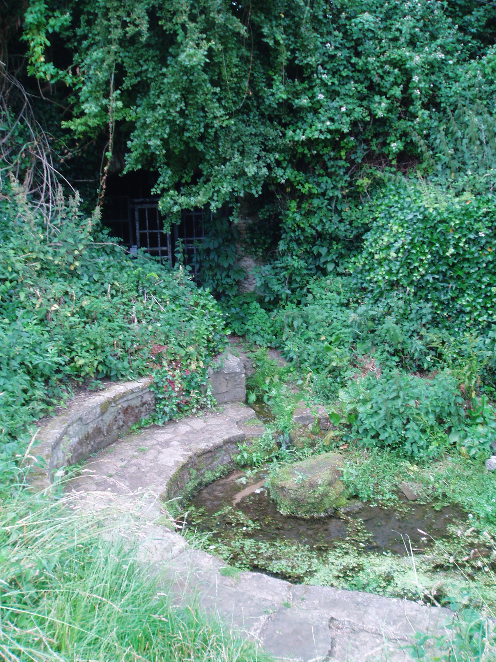
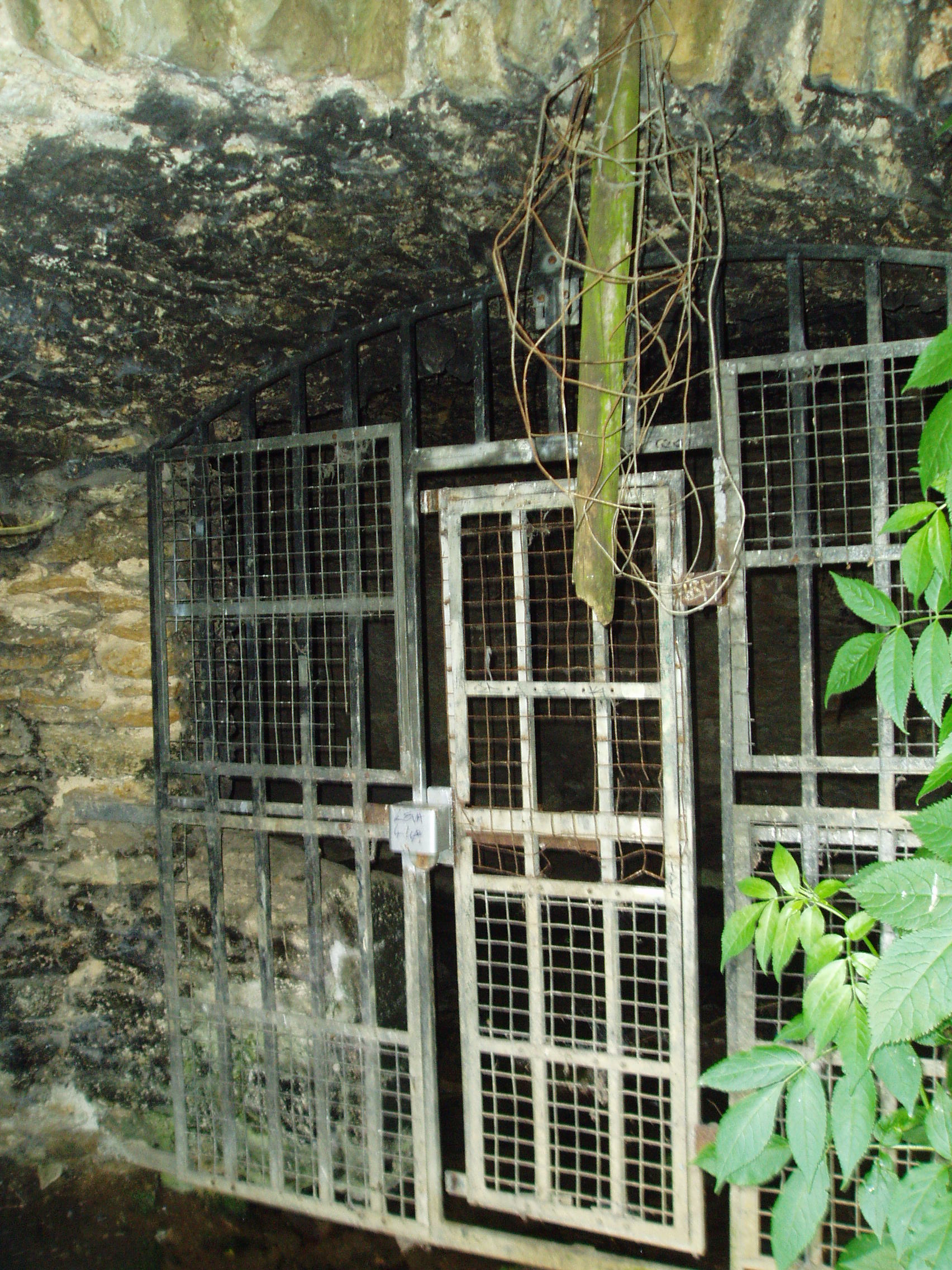
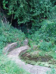
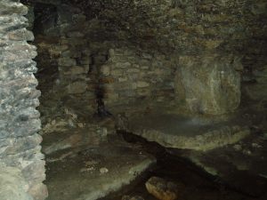
Thompson gives a plan of the well along with an accurate description, which luckily does not differ from the sight which greets the visitor today (although there is now an ugly metal gate on the structure):

‘The subterranean chambers constitute a medley of design and structure; they are not caves, although now underground, but were apparently first built….

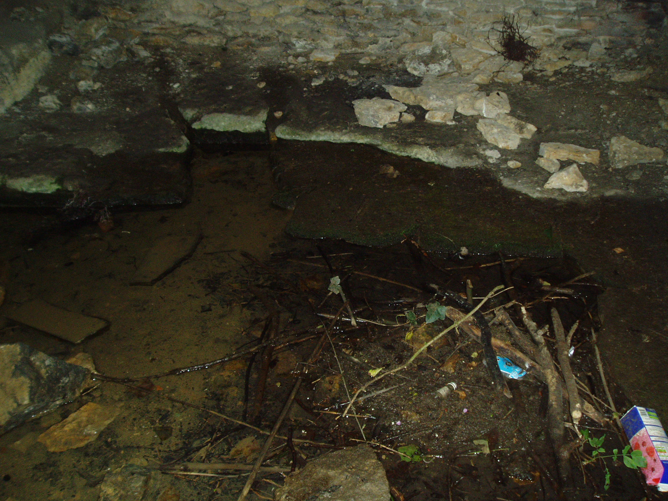
The walls and domed roofs consist of undressed stone. The passage from the pool runs in a direction of N 60 W, and is some six feet long. The entrance being two feet four inches wide by five feet high. The first chamber or antechamber is mostly to the left and nearly at right angles to the passage; it is approximately ten feet by eight feet. In this there is a window high up, evidently a more recent introduction, for the frame is of dressed stone, and the rough stone roof cuts across it, so that external appearance rather than internal use would appear to have been the dominating factor in its design. On the opposite wall of the window is a doorway, and at one time evidently a door, for one stone jamb of dressed stone is left. This doorway opens into the very irregular second or main chamber, roughly twenty feet long, by fifteen feet wide near the widest part. Immediately within the doorway is a well, with dressed stone curb, of three feet internal diameter, and exactly above, in the roof is another smaller circular opening lined with dressed stone as though arranged to draw water from the well from the mound above without going into the chamber, but this is not now open. The well is now choked with stones, but the water used to overflow from the well and run down the passage way to the pool outside, it now flows out oat a lower level leaving the passage way dry. Immediately on the right, after entering the large chamber is am opening leading to a third chamber, smaller, crudely oval, but an indescribable shape, approximately eight to nine feet one way by twelve feet another.

Comparing Thompson’s description and the photograph, one can note a few differences, the main one being that the site in general has become noticeably overgrown. The wall which appears to run along one side has become overgrown and derelict, the pool overgrown, and rubbish-strewn. Within the structure, the curbed well has gone and now one can see the water bubbling from the rock.

Folklore

One side of this is the opening, now blocked up, to a supposed underground passage to Peterborough Cathedral, by which the monks of the Abbey of Burgh, were said to come and bathe in the pool….

To the left of this large chamber, on entering the latter, is a recess some fifteen feet wide and nine feet deep, with a floor consisting essentially of two steps, both apparently of ‘live’ rock, i.e. rock in situ; the upper step being the wider and more like a dais. There is a rather small opening high up on the outer wall of this recess, some five feet from the dais, and is about seventeen inches wide by twenty two feet high, but goes four feet or more in the thickness of the wall or mound without providing an external opening.’

OLYMPUS DIGITAL CAMERAThe site’s greatest fame stems from the tunnel mentioned above by Thompson, which is said to run from the Holy Well to the Abbey at Peterborough. A blocked-up doorway in the third chamber is described as the entrance to this tunnel, although one can imagine that the nature of the whole edifice would lend to such a belief. Certainly records show that the Abbey was supplied by a conduit at the Infirmary end of the Chapel of St Lawrence. However, it is more likely that this took its waters from the St Leonard’s Well at Spital, whose water also filled the Boroughbury Pools and Swan’s Pool.

Yet records show that the Abbey was interested in the site. During Abbot Godfreys tenure, in 1130s the following document states:

Amos ejus viii inclusat porceum Burgi Sumptus iiij I lb: xv sol. Item feat fossutum salveunium inter Thorpe fen et le Dom Sumptus xx sol‘.

Anon 1904-6

OLYMPUS DIGITAL CAMERA OLYMPUS DIGITAL CAMERA OLYMPUS DIGITAL CAMERA


This enclosure cost four pounds and fifteen shillings. Under Abbot Gyerge another document notes the extent of this land (Halywelle), of four acres, three rood and twenty pearches, which until the building of the estate remained the same (Anon 1904-1906). Yet neither of these documents explicitly refers to the laying of a conduit.

The only possible justification for this belief came in November 6th 1964, when workmen, excavating to set up telephone kiosks beside the old Guildhall on Cathedral square, unearthed an underground passage. This continued for twenty five feet under church street, and ran parallel to land belonging to the Almoner’s Garden that was exchanged in the 1194-1200 agreement between the Abbot and the Vicar of Burgh and Longthorpe.  Unfortunately, the underground passage turned out to be some kind of eighteenth century fire precautions.

OLYMPUS DIGITAL CAMERA OLYMPUS DIGITAL CAMERA OLYMPUS DIGITAL CAMERA

Much of the site’s folklore and history derives from a story entitled The Knight of the Red Cross, a story based in the twelfth century, in Richard I’s reign. There is some confusion about the place where this work is published. Thompson (1913)  in his Peculiarities of water and wells states that it is contained within a work called Wild flowers gathered: original pieces in prose and rhyme, printed by J. S. Clarke, with no author or date; whereas  Arrowsmith (n.d) states it comes from a similarly titled, A list of wild flowers found in the neighbourhood of Peterborough, by F. A. Paley. Arrowsmith further notes that the work is advertised on the back of the same author’s Notes on twenty Parish churches round Peterborough, published in 1859. Unfortunately, I have been unable to trace either of these to confirm which is the right source. How much the story is based on any ancient account is unclear. It may be ‘faction’ or fiction, a problem of course with many sites. The applicable parts are produced below as Thompson (1913) notes:

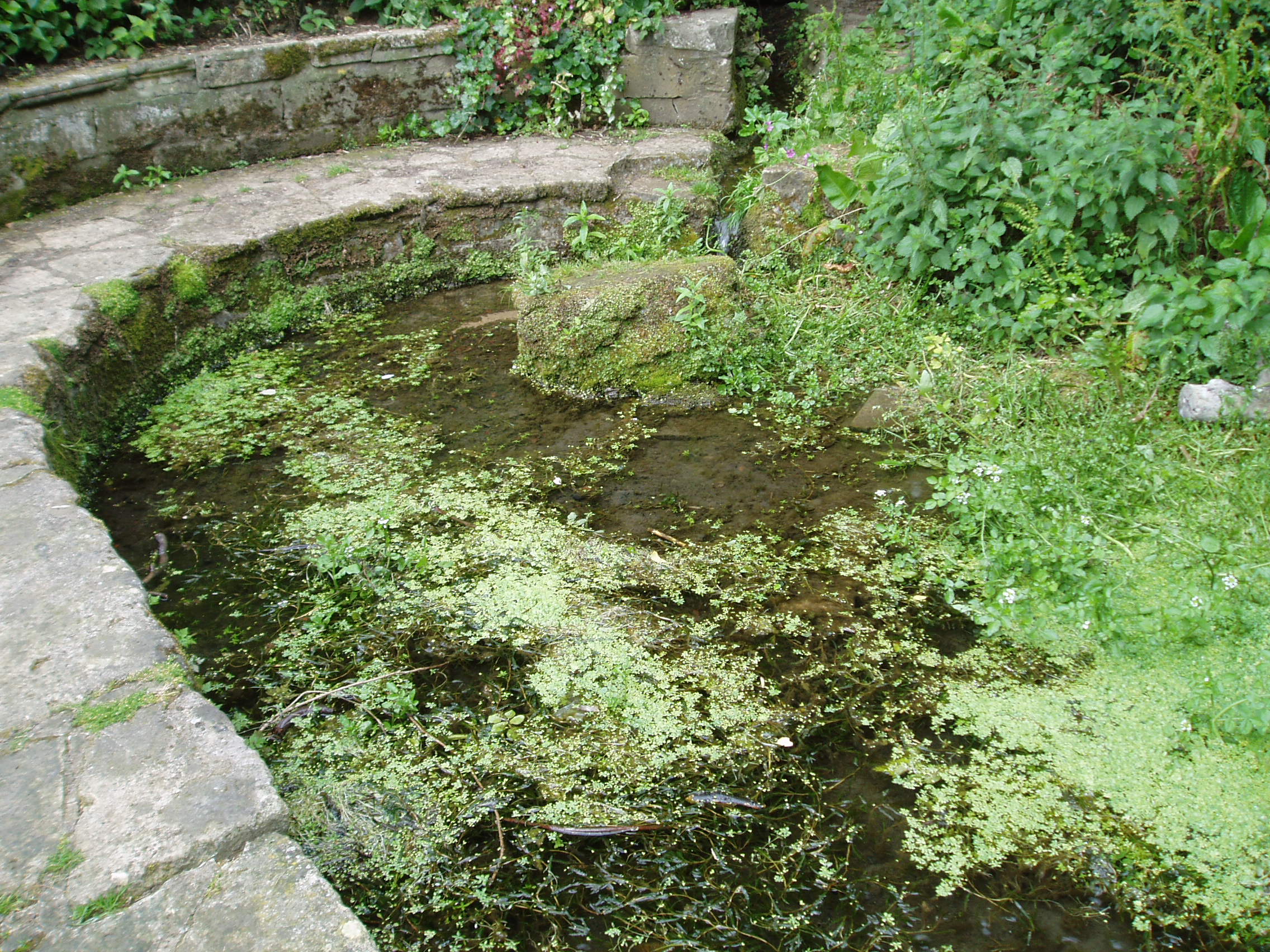
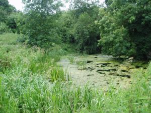
“There is a beautiful spot, called Holywell, in the neighbourhood of Peterborough, well known, and much frequented by the inhabitants. The road lies through a pleasant park, where stands an ancient edifice belonging to the Fitzwilliam family, called Thorpe Hall… After passing the front of this mansion, turn to the left, by the stables and outer buildings will lead, through a white gate, to a small green field from whence this picturesque little spot is seen, with its ivy clad walls, and its dark cypress and yew trees, casting their gloomy shadows around. Passing some broken steps which form the entrance, a shady path conducts to a modern niche, supported by two pilasters, over a slab pavement to a stone basin about six feet in depth and thirty in circumference. This is constantly supplied with clear water, running from the mouth of a subterraneous passage which connects Holywell with the cathedral of Peterborough. An artificial mound of earth is thrown up above this cavity, which is covered with creepers, ground-ivy and a few wild flowers.

Contiguous to the basin are some small fish ponds, partially shaded by beautiful trees; and the green rushes which grow at their bank form undisturbed retreat in which the moor-hen builds her solitary nest. A little further on is a piece of an old pillar, which is gracefully overhung with a wreath of ivy… An old wall surrounding Holywell on two sides, in which traces of windows and doorways are still discernible, is the last feature we shall mention.”

Arrowsmith (n.d) states that these pools have been called ‘Monk’s Stew Ponds’ or ‘Paradise Ponds’, although Arrowsmith considers that the long distance from the Abbey makes it unlikely, as the Abbey was close to good fishing waters  He continues, ‘The waters of this well were formerly in high repute, and were much frequented by those who came on pilgrimages’

Its waters, according to Thompson (1913), are said to be slightly ferruginous, though he detected no sign of it, and nor did I. It was also thought to be efficacious for gout, rheumatism, skin diseases, and good for eyes.

It was believed that a Hermit, called St Cloud, lived at the site. Thompson (1913) continues, quoting J. S. Clarke, that he was ‘of great celebrity, whose pious councils and paternosters were generally in request amongst all pilgrims who visited the spot.’

Some authorities, such as Arrowsmith, have identified this hermit as St Botolph, who is said to have lived within a mile of his chapel during its construction on the Thorpe Avenue site. He is associated with other wells, such as that at Hadstock, Essex, so it is not impossible.

References:

  1. Anonymous, “Holywell,” in Fenland Notes and Queries6, pp.22-4, 1904-6
  2. Arrowsmith, A. L., Longthorpe and its Environs: Microcosm of a Village, privately published: no date.
  3. Bord, J. & C., Sacred Waters, Granada: London 1985.
  4. Parish, R.B., “The Holy Well, or St Cloud’s Well at Longthorpe near Peterborough”, in Living Spring, volume 2, 2002.
  5. Thompson, B., “The Peculiarities of Water and Wells,” in Journal of Northants Natural History Society and Field Club, 18 (135), 1913.

© R.B. Parish, The Northern Antiquarian


Water End Maypole, North Mymms, Hatfield, Hertfordshire

Maypole (removed):  OS Grid Reference – TL 2296 0410

Getting Here

On the east side of Warrengate Road, approached from Welham Green via Dixons Hill Road, or from Brookmans Park via Bradmore Lane.

Archaeology & History

o khy 01170
1920 photo of the Public House. The Maypole is thought to have been in the grounds to the rear

The exact position of the pole is not marked on the 1896 25″ OS map, as it is probable that it had been removed by the middle of the nineteenth century (like the majority of the permanent Hertfordshire maypoles), but local belief in the 1950s and 60s was that it had been in the garden of the Old Maypole (originally known as ‘The Maypole’) public house, which adjoined the smithy in Warrengate Road, Water End.  The public house is stated to have been built around 1520, with later additions, but is now a private house.

The population of Water End and nearby Welham Green was predominantly employed in agriculture, domestic service and straw plaiting, but the area’s proximity to London probably speeded the demise of the ancient traditions like maypole dancing .

Maypole North Mymms
The 1896 OS-map showing the grounds to the rear of the pub

Doris Jones-Baker writes: “The old Hertfordshire maypoles, on May Day decorated with ribbons and a bunch of spring flowers at the top, were described as being ‘as high as the mast of a vessel of a hundred tons, painted often in a diagonal or spiral pattern from bottom to top in yellow and black, or often in vertical stripes of red, white and blue’”

Interestingly, the rear of the public house garden adjoins the Swallow Holes, a geological feature where the intermittent flowing waters of the Mimmshall Brook disappear into the chalk in as many as 15 sink holes. Hertfordshire has an ancient tradition of ‘woe-waters’ related to the local geology, where the flowing or not of a stream or spring was seen to herald ‘sorrow to come’. From personal memory the Mimmshall Brook is normally a dry stream bed which can in winter suddenly turn into a raging torrent, flooding the land behind The Old Maypole. Any tradition of it having been a woe-water has though been lost. But it is just possible that long ago the coming of May Day was also seen to herald the end of flooding of the Mimmshall Brook and may explain the siting of the pole.

The last year that people danced is not recorded, but the local maypole tradition continued; this writer remembers ribbon dancing as a very small child to a fiddle accompaniment around a maypole erected at the nearby, but long demolished Waterend C.E. Primary School, which closed in 1960.

Folklore

As well as Maypole dancing, Hertfordshire had a rich tradition of May day ritual and song, which despite the county’s proximity to London, survived long enough for some of it to be recorded for posterity. While there does not seem to be any ritual recorded for North Mymms, the following was recorded at nearby Hatfield. “On may morning, dressed in white and holding bunches of Hawthorn or, in late seasons, blackthorn blossoms the children sang door to door a local version of the May song, which began:

‘A bunch of May I bring unto you
And at your door I stand,
Come pull out your purse,
You’ll be none the worse
And give the poor Mayers some money….’”

References:

  1. North Mymms Local History Society, North Mymms Pictures From The Past, Welham Green, 2002
  2. Jones-Baker, Doris, The Folklore of Hertfordshire, B.T.Batsford, London, 1977
  3.  Kingsford, Peter, North Mymms People in Victorian Times, Brookmans Park, Hertfordshire, Privately Published, 1986

© Paul T. Hornby 2016 The Northern Antiquarian 


Robin Hood & Little John Stones, Whitby, North Yorkshire

Standing Stones (destroyed?):  OS Grid Reference – NZ 9171 0952

Also Known as:

  1. Robin Hood’s Pillars

Archaeology & History

The 2 stones on 1853 map

The 2 stones on 1853 map

References to these old standing stones are scarce—at least in archaeology books anyway.  Even the usually diligent masters of Burl (1993) and Thom (1990) missed them!  But thankfully our folklorists and antiquarians with their keen interest in popular culture have written about these long lost monoliths, which could once be seen in fields just a mile or so south of Whitby town.

The earliest known account of the site is as the “Robyn-Hood-stone” in records dating from 1540 CE cited in the Cartularium Abbathiae de Whiteby (1881).  It was later described in land registers in 1713 and the fields in which they stood were—and still are—respectively known as Robin Hood’s Close and Little John’s Close.

These Whitby monoliths—like their namesakes in Northamptonshire— weren’t too big.  In Mr Young’s (1817) early description, when the stones were still visible, he told how Robin Hood’s stone was “a stone pillar about a foot square and four feet high”, and Little John’s Stone was “a similar pillar about two-and-a-half feet high.”  Mr J.C. Atkinson, the editor of the Cartularium (1881), also told that the two stones were “still in situ in the earlier part of the present century,” continuing:

“Both stones have now been removed, and are, I was informed, set up again near the enclosing fence of the field in which they stood. Almost beyond question , like the other monoliths of the district, they marked the site of ancient British interments.”

So—do the remains of these old stones still exist somewhere close by as J.C. Atkinson said, either in the walling, as a gatepost, or just pushed over and now covered in grass (like the long lost Thief Thorne standing stone near Addingham)?  Are any northern antiquarians living close by who might enable their rediscovery?

Folklore

A number of writers exploring the mythic histories of Robin Hood have included this site in their surveys, usually repeating the earlier creation myths about them that could be heard in popular culture.  The Whitby historian George Young (1817) told the tale:

“According to tradition, Robin Hood and his trusty mate, Little John, went to dine with one of the Abbots of Whitby, and, being desired by the Abbot to try how far each of them could shoot and arrow, they both shot from the top of the Abbey, and their arrows fell on the west side of Whitby Laithes, beside the lane leading from thence to Stainsacre; that of Robin Hood falling on the north side of the lane and that of Little John about a hundred feet further, on the south side of the lane.”

Whitby folklorist P.S. Jeffrey (1923) took this myth literally, saying how the distance of the arrows fired by the respective folk heroes was “scarcely credible, as the distance in each case is about a mile-and-a-half.”  However, the earlier historian Lionel Charlton (1779) thought the incredible feat quite credible!

The distance between the Abbey and the stones is 1.36 miles (2.2km); but it may be that the direction related in the tale was more important than the distance, as the alignment between the two sites runs northwest to southeast—or southeast to northwest, whichever you prefer!—and may relate to an early astro-archaeological alignment.  Might…..

References:

  1. Anonymous, “Robin Hood in Yorkshire“, in Yorkshire Folk-Lore Journal – volume 1, T.Harrison: Bingley 1888.
  2. Anonymous, “Whitby Arms,” in Yorkshire Folk-Lore Journal – volume 1, T.Harrison: Bingley 1888.
  3. Benedicti, Ordinis S., Cartularium Abbathiae de Whiteby – volume 2, Andrews: Durham 1881.
  4. Burl, Aubrey, From Carnac to Callanish, Yale University Press 1993.
  5. Charlton, Lionel, The History of Whitby and Whitby Abbey, T. Cadell: York 1779.
  6. Doel, Fran & Goeff, Robin Hood: Outlaw or Greenwood Myth, Tempus: Stroud 2000.
  7. Green, Barbara, The Outlaw Robin Hood – His Yorkshire Legend, KCS: Huddersfield 1992.
  8. Gutch, Mrs, County Folk-lore – volume 2: North Riding of Yorkshire, York and the Ainsty, David Nutt: London 1901.
  9. Jeffrey, P. Shaw, Whitby Lore and Legend, Whitby 1923.
  10. Mitchell, W.R., Exploring the Robin Hood Country, Dalesman: Clapham 1978.
  11. Parkinson, Thomas, Yorkshire Legends and Traditions – volume 2, Elliot Stock: London 1889.
  12. Thom, A., Thom, A.S. & Burl, Aubrey, Stone Rows and Standing Stones – 2 volumes, BAR: Oxford 1990.
  13. Young, George, The History of Whitby and Streoneshalh Abbey – volume 2, Clark & Medd: Whitby 1817.

© Paul Bennett, The Northern Antiquarian


Moor Lane Well, Gomersal, West Yorkshire

Healing Well:  OS Grid Reference – SE 2071 2677

Archaeology & History

Moor Lane Well on 1847 OS-map

Moor Lane Well on 1847 OS-map

Not far from the old maypole, the Moor Lane Well was the innocuous-sounding site where legend told that a phantom horse was once seen running up and down the lane—said by old locals to be a “very ancient highway”.  It was also a place where we find an intriguing tale of local disrepute, that brought humiliation to the culprit from the entire village.

There used to be a custom called ‘Riding the Stang’ which persisted in Yorkshire until the end of the 19th century. Thought to be of Scandinavian origin, it involved the culprit being hoisted onto a platform, held up by poles, then carried around the village where the person lived in a most ignominious procession. It was invariably described as being a public punishment and humiliation for faults made by one’s wife. Anyway, in the early 1840s, said H.A. Cadman (1930),

“there were two families who lived at Brecks Farm.  I will not of course divulge their true names, so will describe one of them as the Jones family and the other as the Smith family.  Jones’ wife accused Smith’s wife of having polluted the drinking water and the Smith family left the farm and removed to the top of Moor Lane.  The Jones family wishing to make the most of the affair resolved that Mrs Smith’s effigy should ride the stang.  A long pole was obtained and the effigy was affixed to the centre.  Two men then took hold, one at each end, and walked up Moor Lane, folowed by a huge concourse of people.  The procession stopped opposite Mrs Smith’s house and repeated the nominee.  My informant, a dear old lady, would not tell me the whole of the verse, but it commenced thus:

“It’s neither your fault nor my fault that I ride this stang.”

“After all the verses had been repeated, the stang was taken round Gomersal, when ultimately the effigy was burned with the usual solemnities.

“The other instance of riding the stang occurred also in thge early ‘forties and I believe this was the last occasion of the stang being ridden.  On this occasion a man…was in the habit of beating his wife harder than his neighbours thoughts proper with the result that he had to be punished. Now Jim was a most religious man, but the same rites had to be observed as in the other instance,

“It was for Jim Vasey that religious man
He paid her, he paid her indeed and
If Jim doesn’t alter his manners
We will take his skin “…….” to the tanners.
And if the tanner doesn’t tan it well,
We’ll send it to…”

“One must regret that the old custom of riding the stang has died out, as it must have had its good points.”

Local people could, of course, simply bring it back again!  The Moor Lane Well was one of the main water supplies for the old villagers in bygone times, but seems to have disappeared under the modern houses.  There is, however, a small narrow band of trees where the old waters once ran, amidst which it might still be found—if luck is on our side…

References:

  1. Cadman, H. Ashwell, Gomersal, Past and Present, Hunters Armley: Leeds 1930.

© Paul BennettThe Northern Antiquarian


Mannerly Well, Gomersal, West Yorkshire

Healing Well:  OS Grid Reference – SE 2107 2515

Also Known as:

  1. Manor Lea Well

Archaeology & History

The site is one of the 2 wells on the 1847 OS-map

The site is one of the 2 wells on the 1847 OS-map

Originally called the ‘Manor Lea Well’ because it could be found on the far west of the land belonging to the Manor House, the name later became corrupted to ‘Mannerly’ by local folk. It was one of the four prime water supplies for this part of the old village, but it had other important social and festive rites attached that undoubtedly went back centuries.  H.A. Cadman (1930) told that:

“On Palm Sundays it was the custom for boys to take bottles containing Spanish juice, treacle, and any other sweet thing they could, for the purpose of having them filled with the water from the well. The boys then exchanged bottles with each other and each sampled the others. It was said that no better water existed for this purpose.”

This particular ritual was integral to virtually every Spa Well from Wakefield through to the source of the River Calder.

A Mr G.W. Parker said that the well was to be found at the “extreme Western side” of Manor Lea and was “still in existence” when Cadman wrote about it in 1930, “behind Company Mill” not far from the Moravian Burial Ground.  Do any local historians know if the well is still there, or has it since been destroyed?

References:

  1. Cadman, H. Ashwell, Gomersal, Past and Present, Hunters Armley: Leeds 1930.

© Paul BennettThe Northern Antiquarian


Gomersal Maypole, West Yorkshire

Maypole (destroyed):  OS Grid Reference – SE 2068 2672

Archaeology & History

As in countless villages and towns across the British Isles, Gomersal also once had its maypole near or at the village centre.  We don’t know when the first maypole was erected in the village and many local sites were openly destroyed by rampant christian puritans and similar idiots.  It stood not far from the Moor Lane Well and was described by the regional historian H.A. Cadman (1930), who told:

“The Maypole was at the top of Moor Lane and one can imagine the welkin echoing to the very old song:

‘Come lasses and lads take leave of your dads
And away to the maypole hie.
For every fair has a sweetheart there
And the fiddlers standing by.
For Willy shall dance with Jane
And Johnny has got his Joan.
To trip it, trip it, trip it, trip it,
Trip it up and down.’

Yet as with maypoles up and down the land, testosterone-fuelled Springtime fall-outs happened.  Mr Cadman told:

“Very often May Day gatherings ended up with fights.  Great jealousy always existed between the inhabitants of Great Gomersal, Little Gomersal and Spen.  There is a tradition which has been handed down that the last Maypole in this district stood on Liversedge Green.  This Maypole was demolished in a fight by the Gomersalians and there is a similar tradition about the Maypole on Cleckheaton Green, so as Mr Frank Peel says, “It is evident that ancient inhabitants of Gomersal were more pugnacious than their neighbours.”  I have no evidence when the Gomersal Maypole ceased to exist, but there is abundant evidence to prove that there was one in Gomersal, the proof being that the vane is now in Batley Museum.  It is in the form of a fish.”

If anyone has any further information on this important relic, or its history, please let us know.

References:

  1. Cadman, H. Ashwell, Gomersal, Past and Present, Hunters Armley: Leeds 1930.

© Paul BennettThe Northern Antiquarian


Hawklemass Well, Whittingham, Northumberland

Healing Well:  OS Grid Reference – NU 0683 1228

Archaeology & History

Hawklemass Well on 1866 map

Hawklemass Well on 1866 map

References to this site seem very scarce.  A well is highlighted on the 1866 OS-map of the region close to the spot which D.D. Dixon (1895) said it was found, “near to the Howbalk Lane end, where is also the Hawklemass Stile and Hawklemass Well.”  A stone trough could once be seen here, but its presence today needs to be confirmed by local researchers.  The site is listed in Binnall & Dodds (1943) survey, but with no additional comments to those made by Mr Dixon.

Folklore

The historian D.D. Dixon (1895) told that the village of Whittingham only had one ghost, but it was known as the “Hawklemass Ghost” and was occasionally encountered at the Hawklemass Well:

“This was a place never passed after nightfall by the youth of the village without feeling an eerie, creepy sensation, and with many a furtive glance on either side.  This unearthly visitant, in its gambols and uncanny pranks, was said to rattle the chain by which it was supposed to be bound in a fearsome manner.  It was usually seen or heard by persons who, having lingered long at the village inn, could say with Tam o’ Shanter,

“While we sit bousing at the nappy,
An gettin’ fou and unco happy,
We think na on the lang Scots miles,
The mosses, waters, slaps and styles,
That lie between us and our hame.”

One Saturday night many years ago—perhaps fifty—a poor fellow on his way from Whittingham to Glanton fel into the roadside at Hawklemass, where he was found, quite dead, the next morning by some persons on their way to Glanton meeting.  This sad affair may have given rise to the tradition of the Hawklemass Ghost.”

The name of the old lane at whose junction the Hawklemass Well once flowed, ‘Howbalk Lane’, may derive from a lost tumulus, as the word how (and its variants) regularly relate to prehistoric mounds in our more northern climes.  Such an ancient tomb, close to the well, may be the origin of the ghost story.

References:

  1. Binnall, P.B.G. & Dodds, M.H., “Holy Wells in Northumberland and Durham – part 2”, in Proceedings of the Society of Antiquaries Newcastle-upon-Tyne, 10:2, 1943.
  2. Dixon, David Dippie, Whittingham Vale, Northumberland, Robert Redpath: Newcastle 1895.

Acknowledgements:  With thanks to Gill Rutherford for prompting me to finish this; and to Claire Heron for the OS-map reference.

© Paul BennettThe Northern Antiquarian