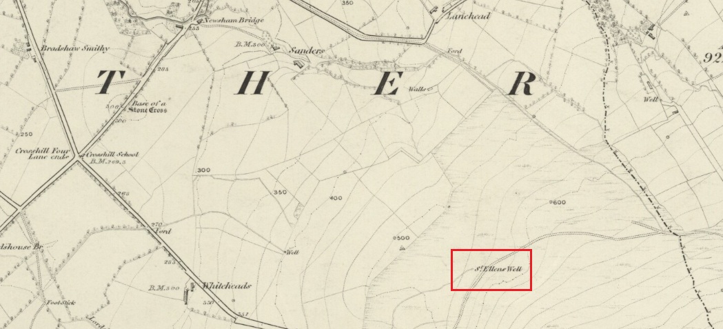
Approaching the site from the north, walk along the Lane Head track, and along the path south-eastwards, then turn right onto the main footpath until coming to the stream. Follow the stream up the fell to the large clump of reeds, then follow your ears until you locate the spring! Or you can approach it along the main footpath from the Oakenclough – Galgate road. The well and the path to it
are on access land.
Archaeology & History
Fortunately recorded by the Ordnance Survey on their 1846 6″ map Lancashire XL, the story of St Ellen’s Well was taken up sixty years later by local holy wells historian Henry Taylor (1906):
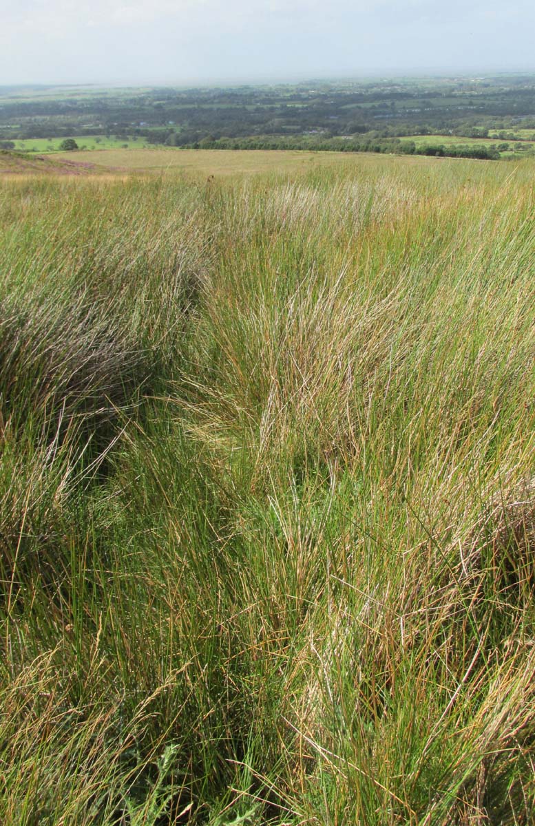
Listen for the spring in the reeds
“The site of this holy well is marked on the ordnance map at a lonely spot on Harris Fell, five hundred feet above the sea-level, four and a half miles in a north-easterly direction from the town of Garstang.
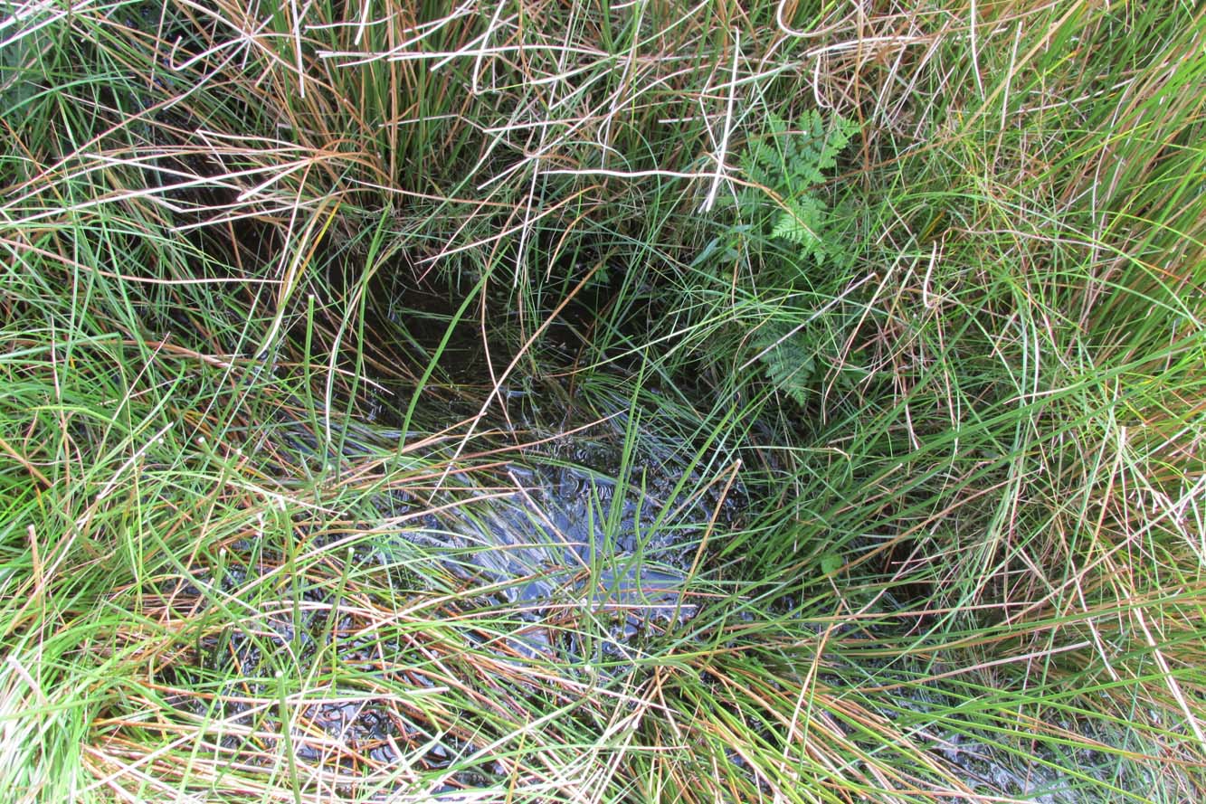
“Mr. A. King has kindly examined the site. He writes, 4th August, 1902: “We had no difficulty in locating the spot…. There is no outward indication of the place being used for curative means, and there is no stonework at all. It is a beautifully cold spring which is at the side of ‘Bonny Pad’, a pathway leading across the moor from Harris End, and it was grown around with rushes…. All I can glean about it is that one of the oldest inhabitants, when asked if he knew of it, replied, ‘It will be th’ holy well, you mean.'”
The original dedication of this remote holy well was clearly to St. Helen, and its presence next to the Bonny Pad or path may indicate a pre-Christian dedication to a local cognate of the Celtic Elen Luyddog, Elen of the hosts or ways. The Bonny Pad is shown but not not named on the 1846 map, and follows a broadly southwest to northeast direction from Harris End (again not named on the 1846 map) up to Grizedale Head on the southern edge of the Catshaw Vaccary. It was perhaps an ancient route used by farmers to take their animals up onto the fell for the summer, and return them to the lowlands in the autumn.
Bubbling away at source
The western portion of Bonny Pad is not shown on the modern map and St Ellen’s Well is not marked, and both have it seems passed out of local memory. An elderly farmer I encountered on my way up to the fell had never heard of the Well.
It is certainly worth the walk if only for the delightful sound of this powerfully flowing spring, the water is pure and cold, and it commands a fine view over the Lancashire plain to the coast.
References:
Taylor, Henry, The Ancient Crosses and Holy Wells of Lancashire, Sherratt & Hughes: Manchester 1906.
Wise, Caroline, “Elen of the Roads of Country and Town”, in Finding Elen – The Quest for Elen of the Ways, edited by Caroline Wise, Eala Press: London 2015.
This stone has very similar qualities to the one found upon Mullach-geal, ⅔ of a mile to the west, as a place where ritual magick was performed. And, just like the Mullach-geal stone, we only have an approximate position of its whereabouts: “behind the village”, as Mr Sands (1878) said. The same words were used by other St Kildan writers when it came to describing the whereabouts of Tobar Childe, so we must assume it to be reasonably close to the old well.
Folklore
Mr Sands seems to be the first person to write about it, telling us,
“At the back of the village is a stone, which does not differ in external appearance from the numerous stones scattered around, but which was supposed to possess magical properties. It is called Clach an Eolas, or Stone of Knowledge. If any one stood on it on the first day of the quarter, he became endowed with the second sight — could “look into the seeds of Time,” and foretell all that was to happen during the rest of the quarter. Such an institution must have been of great value in Hirta, where news are so scanty. To test its powers I stood on it on the first day of Spring (old style) in the present year, but must acknowledge that I saw nothing, except two or three women laden with peats, who were smiling at my credulity.”
Charles MacLean (1977) mentioned the stone a hundred years later, but seems to have just copied this earlier description. Does anyone up there know its whereabouts?
References:
MacLean, Charles, Island on the Edge of the World, Canongate: Edinburgh 1977.
This is a most intriguing site, whose exact location seems to have been forgotten. It was first mentioned in Macaulay’s History of St Kilda (1764) as being one of four stone altars that the islanders used for worship. Three of them were related to the early christian figure of St. Brendan, whose well and chapel remains are on the south-side of the island. However, this fourth stone altar possessed a purely magickal and heathen function. Macaulay initially gives the location as being “on top of a hill to the southwest” of St. Brendan’s chapel; but subsequently tells us it was upon “Mulach-geall” which is a mile NNW. It was an important place to the people of Hirta and its exact position needs to be found and, hopefully, the altar still exists.
Folklore
Despite Macaulay’s conflicting directions of how to get here (a common feature of early writers), he wrote:
“I have already made mention of one St. Kilda altar, that in Brendans Chapel. There are no less than four more in the island, of which three lie at considerable distances from the holy places. There is one particularly on the top of a hill to the south-weft (sic), dedicated according to tradition to the God who presides over Seasons; The God of thunder, lightning, tempests and fair weather. To avert the terrible judgments inflicted by this mighty Divinity, the ancient St. Kildians offered propitiatory sacrifices on this altar, sacrifices of different forts, much like the old Pagans, who offered a black sheep to Winter, or the Tempest, and a white one to the Spring… The place where the people of this island, offered their victims to Taranis, is called Mulach-geall, that is to say, the White eminence or hill…”
More than a hundred years later, Seton (1878) made mention of it, but added no further details.
The invocation to Nature’s elements is something we find echoed at some sites further east, such as the Well of the North Wind on Iona and its compatriot Well of the South Wind. At both these places, so-called ‘pagan’ rituals were used to both placate and invoke the gods and spirits of the wind. This one on St Kilda possessed additional magickal prowess. But where is it? Have we lost it, or is it sleeping somewhere on the edge of Mullach-Geal…?
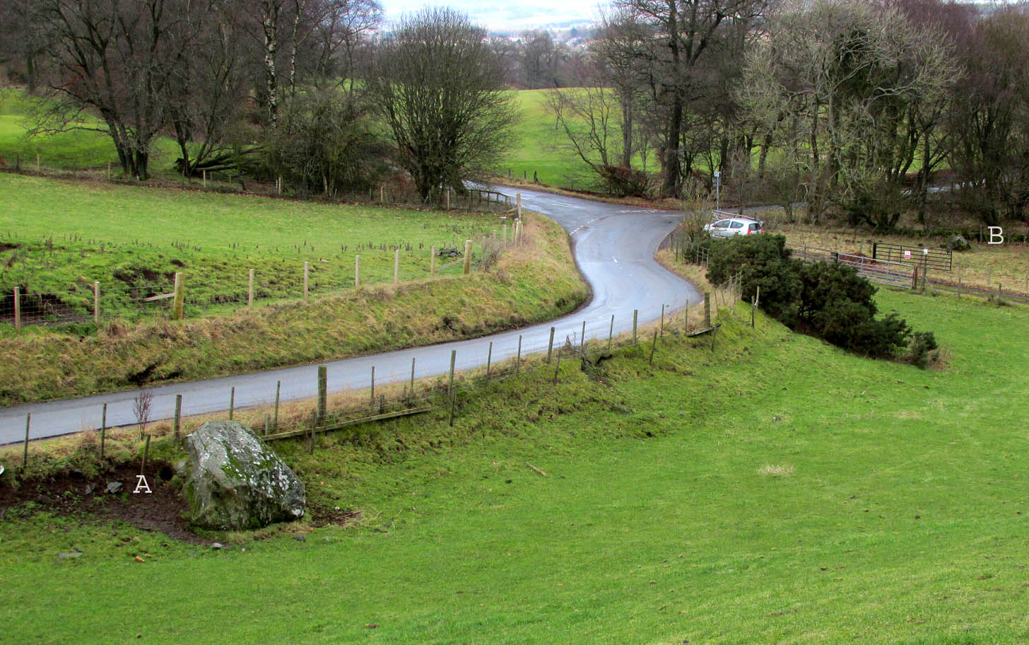
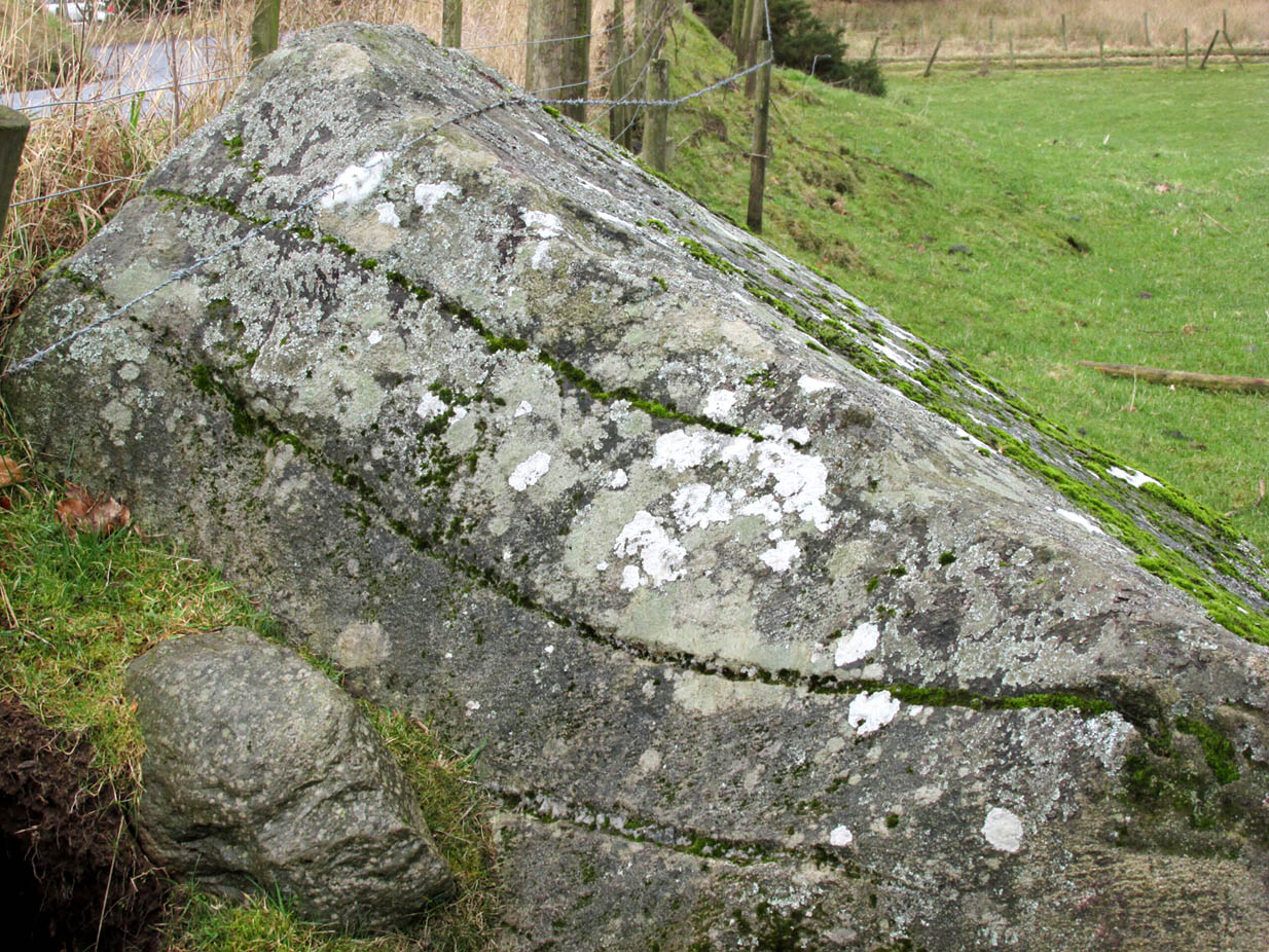
Travelling north from Perth on the A94, take the right turning for Murrayshall just before entering Scone, then take the first right and continue up to the road junction, and park up at the trackway opposite. You’ll see the big stone in the field to the right, up against the road embankment; and the small stone is in the paddock to the left of the trackway at the edge of the trees.
Archaeology & History
Two large glacial erratics which have acquired mythic status and picked up a Christian triumphalist message on the way.
Folklore
In Lawrence Melville’s (1939) excellent local history work, he thankfully put to pen an all-but-forgotten tale of oral tradition:
“Where the road from the Muir of Durdie leaves Kilspindie parish, a grass grown road leads north to Boglebee….. A few yards from the highway lie two large stones, said to have been flung from the Giant’s Hill in Collace parish – the flat topped eminence lying due north from the stones, about two or three miles away, better known as “Macbeth’s Hill”, or “Dunsinane Hill”.
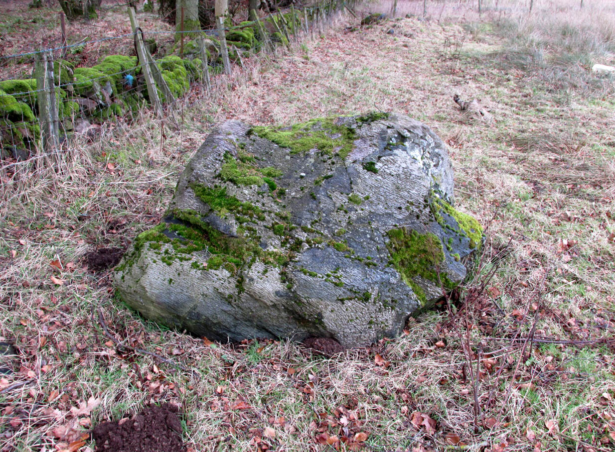
The ‘string’ marks of legendThe smaller stone with its ‘string’ marks
“When the church dedicated to St John in Perth was being built and its tower began to appear, a witch living in Collace was enraged to see this proof of the approach of Christianity and determined to destroy it. She had a son, a giant (after whom the hill receives one of its names), whom she sent to the top of the hill, giving him two huge stones with which to destroy the rising church.
“By her incantations she had supernatural power and knew that when Christianity came her power would be destroyed. She gave him her mutch from her head to be used as sling and in it the giant put the two huge stones. Whirling it around his head, he aimed them in a line with the tower, but, just as he let them fly, the string of his mother’s cap broke and the stones only went the length of Boglebee. The marks on the stones are said to be the marks of the witch’s mutch strings.”
Another view of the larger stone
A familiar folkloric message is remembered the length of Britain: a giant, a devil or other supernatural being throwing stones that either spill out of an apron or otherwise miss their mark. And in this case an unsubtle message to anyone trying to take on the might of the church. But what was the original story of these stones as told by the old time oral storytellers before Christian missionaries stalked the land?
If the string hadn’t broken and the stones had followed their original trajectory they would have fallen south of St John’s Kirk, but it was the thought that counted….
Reference:
Melville, Lawrence, The Fair Land of Gowrie, William Culross: Coupar Angus, 1939.
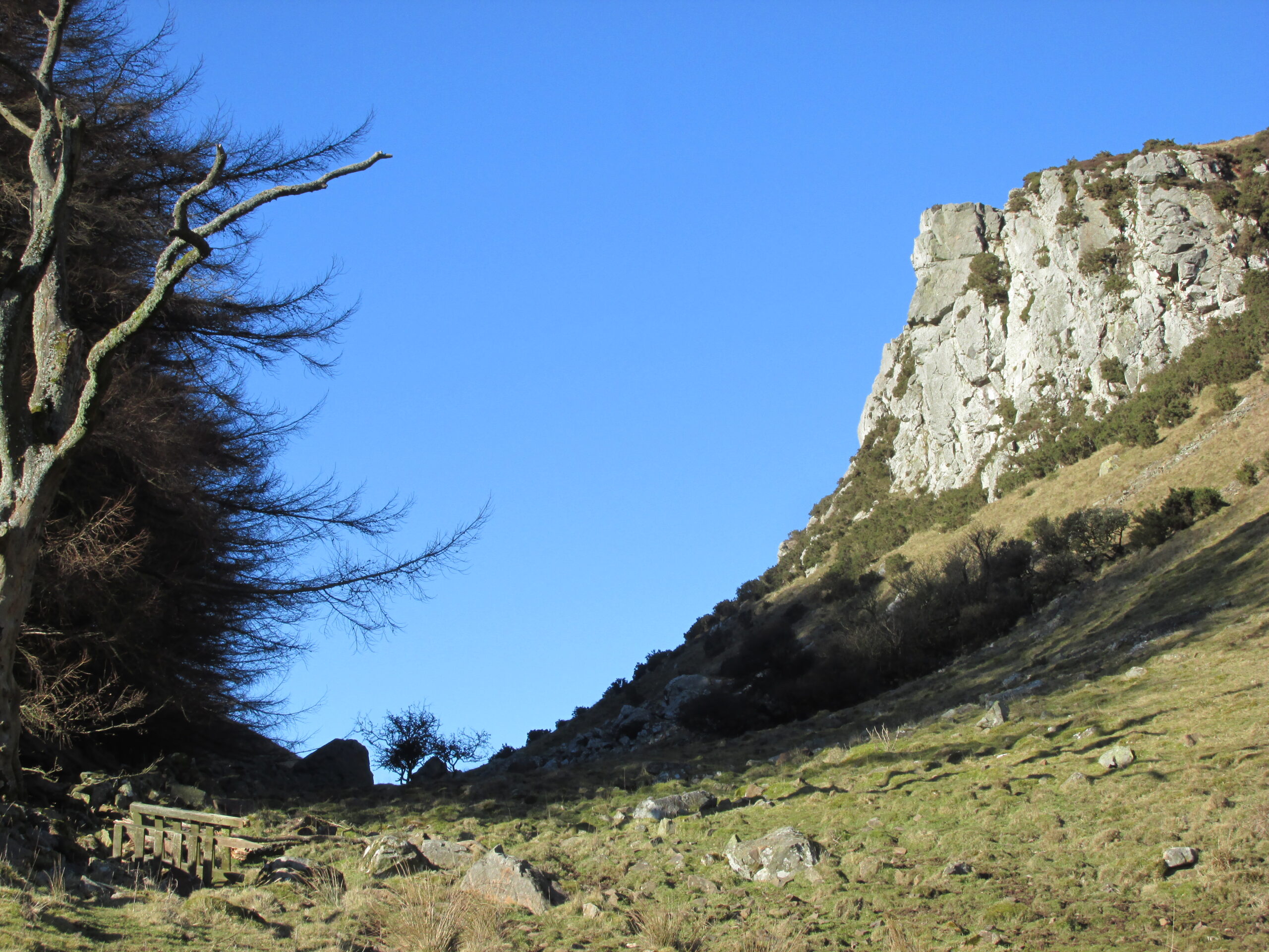
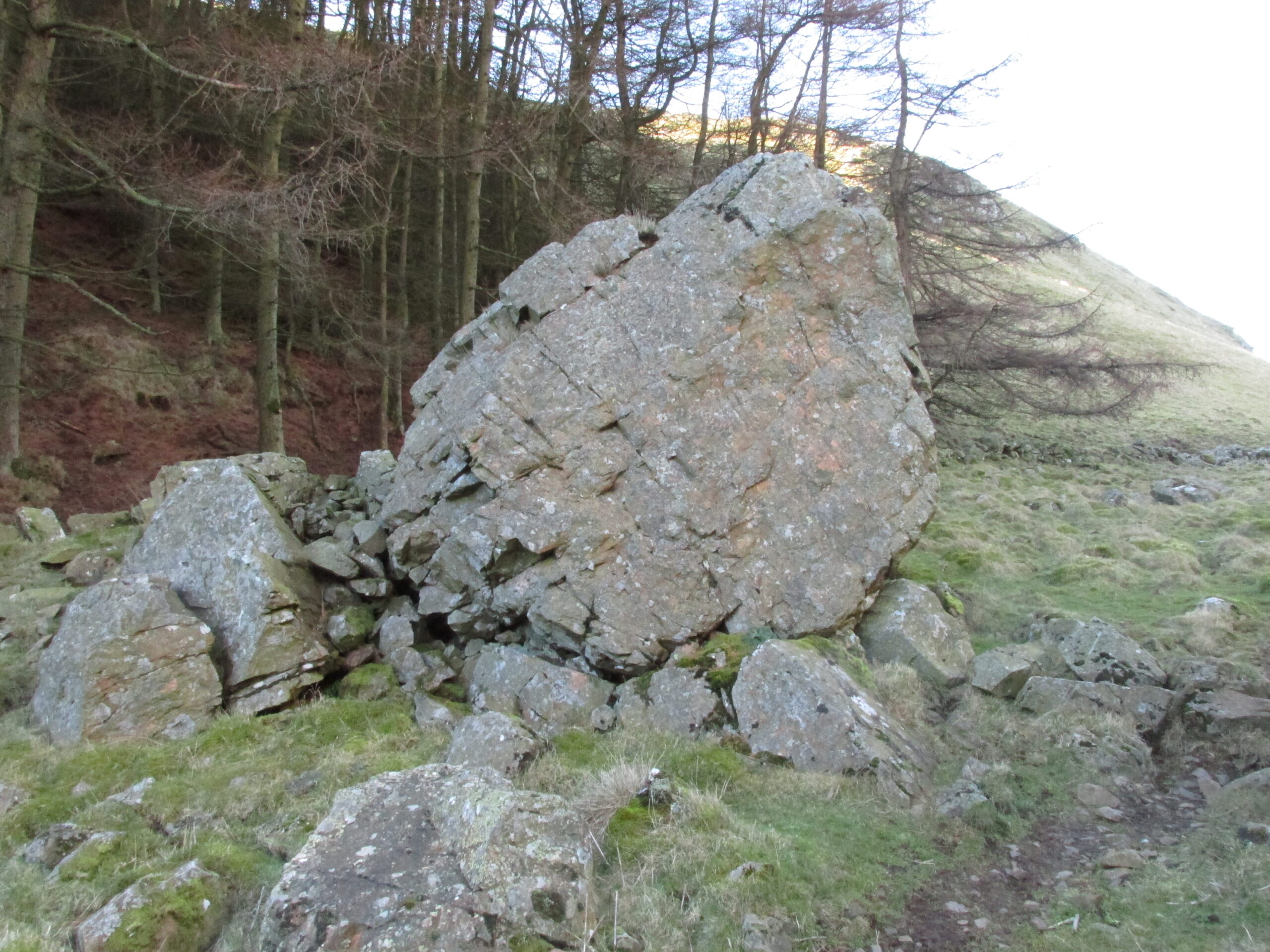
The Rock and Leap may be seen from the B953 Bandirran to Abernyte road. Approach across the fields.
Archaeology & History
A large boulder perhaps 40 tons in weight lies in a ravine between Dunsinane and Black Hill. The ‘Leap’ is a flat topped ledge jutting out from the west side of Black Hill facing Dunsinane.
Folklore
Melville (1939) in his The Fair Land of Gowrie writes of the simple pleasures of the giant:
“From the farther side of the ravine [between Dunsinane and Black Hill], a precipitous rock juts out, which is called the “Giant’s Leap”. According to the lore of the Sidlaws, a giant, who once lived in these parts, leaped from this rock right on to the top of Dunsinane Hill. The giant also amused himself by tossing about a huge boulder which can be seen lying at the bottom of the ravine.”
And adds:
The Big Fellow’s toyGiant’s Leap from the north
“Fairies haunted the hills here and on summer nights they descended to the meadows, where they danced at a spot called “Fairygreen”. The Black Hill gets its name from the dark heath which covers it. Weird and bleak looking for most of the year, the lower slopes are brightened by glowing patches of purple flowers in late summer.”
Fairygreen Farm lies a mile almost due north of Dunsinane.
Reference:
Melville, Lawrence, The Fair Land of Gowrie, William Culross & Son, Coupar Angus, 1939.
Legendary Tree (lost): OS Grid Reference –TL 96 28
Archaeology & History
In more than twenty volumes about Robin Hood in the Northern Antiquarian library, no mention can be found of this all-but-forgotten site, first recorded (I think) in September 1637, in the boundary perambulation account of northern Colchester. In days of olde, folk walked the boundaries annually and so the description given here follows their very footsteps – although the landscape has obviously been altered in places since then. Because of the length of the entire perambulation their account is rather long, so I’ve cut to the piece relating to our legendary oak tree, which gives a good idea of its location. We meet up with them at a place called Motts-Bridge, just above a place that is today called Seven Arches Farm (TL 9630 2595):
“…and so over Mott’s-bridge, and so cross the river by Nicholas Ayleward’s howse into the meadowe crossinge over to the lower ende of West-fielde, and from thence to Buttolph’s brooke leavinge the Brooke alwais upon the left-hand, and so along to Thomas Abrige (which is righte against Robin Hood’s oake). And from thence to Black-brooke under Chesterwelle and so along the Rampiers by Horkesley Heathe to the brooke that is under Langham-park-corner…”
The description of its whereabouts isn’t too clear, but in a subsequent and much longer perambulation account from August 1671, some extra topographical features are mentioned. Starting not far from Mott’s Bridge, down Shett’s Hill to Newbridge,
“and then into the Fields in the occupation of Matth. Ayleward…through a gate a little above the Bridg: and soe along to Matth. Ayleward’s Yard, crosse the River into Matth. Ayleward’s Meadowe, and crosse that Meadowe into the lower part of Westfields, neare to which is a Foote-bridge cross the river, which is called Mott’s-bridge. And soe along through West-fields to a Gate in a lane at or neere the north ende of a Meadow of one Mrs —, now in Samuel Duglet’s occupation, which lane parts West-fields from Bergholt, as the Parsons of each Parish, whoe were both present, affirmed; and, upon a Tree standing neere to which Gate is set a crosse. And from thence to Butolph’s brooke, leaveing the brooke allwaies upon the left-hand; and soe along through Mr Leming’s Meadows and Woods at the ende of them to a Bridge called Thomas Abridge, leading on to Horkesley Heath, which bridge is right against Robin Hood’s Oake, that stood on the pitch of the hill. And from thence along the Naylande Roade over Horkesley-heathe to Blackbrooke under Chesterwell, which Brooke runnes crosse the way at the foote of Horkesly cawsy…”
This second account seems to speak of the tree in the past tense, telling us that “Robin Hood’s Oake, that stood on the pitch of the hill”, but we can’t be completely sure. I presume that there’s no longer any trace of this legendary oak tree; however, considering the fact that oaks can live to an incredible age, it may be worthwhile for a local antiquarian to follow this ancient boundary and see if, perchance, any remaining tree stump might still be there. Y’ just never know…..
There are several other place-names in Essex relating to our mythical outlaw, including Robinhood End at Finchingfield described in 1699, and a farm of the same name nearby; plus a Robin Hood’s Inn near Loughton. (Reaney 1935) There are probably a few more hiding away in field-name records…
NB:The grid-reference map linked to this site is an approximation. If someone can find the exact spot where the tree stood, we’ll update its position.
References:
Morant, Philip, The History and Antiquities of the Most Ancient Town and Borough of Colchester, W. Bowyer: London 1748.
Reaney, P.H., The Place-Names of Essex, Cambridge University Press 1935.
The exact location of this site seems to have been lost. One possible candidate is on the south-side of the village where remains of a large moat exists, meaning that there was a good water supply here to maintain its existence. But this is pure guesswork on my part. The well was mentioned briefly in R.C. Hope’s (1893) classic book where he told us:
“There was a holy well or spring in the village of Holwell, on the borders of Bedford and Hertfordshire; unfortunately both history and site have been forgotten by the villagers at Holywell.”
The site was mentioned as far back as 1086 CE in the Domesday Book as ‘Holewelle’. The place-name authorities Gover, Mawer & Stenton (1938) tell us this derives from a “spring in the hollow” and not a holy well as subsequent writers profess. The only thing that could perhaps fortify the ‘holy’ element is that in some instances early citations of holy wells are written as holi- wells, which this may have been. As all historians know, early spellings of sites are far from accurate.
References:
Gover, J.E.B., Mawer, Allen & Stenton, F.M., The Place-Names of Hertfordshire, Cambridge University Press 1938.
Hope, Robert Charles, Legendary Lore of the Holy Wells of England, Elliott Stock: London 1893.
Smith, A.H., English Place-Name Elements – volume 1, Cambridge University Press 1956.
Tumulus (destroyed): OS Grid Reference – SE 1676 1504
Archaeology & History
The only thing we know of this long lost site comes from a tradition narrated by the Canon Hulbert (1882) in his definitive history of Almondbury parish. High up the hill near the very top of the village where All Saints Church was built, he told how tradition said,
“that a tumulus or mound existed at the west end where now the Clerk’s house stands; which may have been an ancient British site and led to the erection of the church.”
Sadly, there seems to be no further information about the site.
References:
Hulbert, Charles A., Annals of the Church and Parish of Almondbury, Longmans: London 1882.
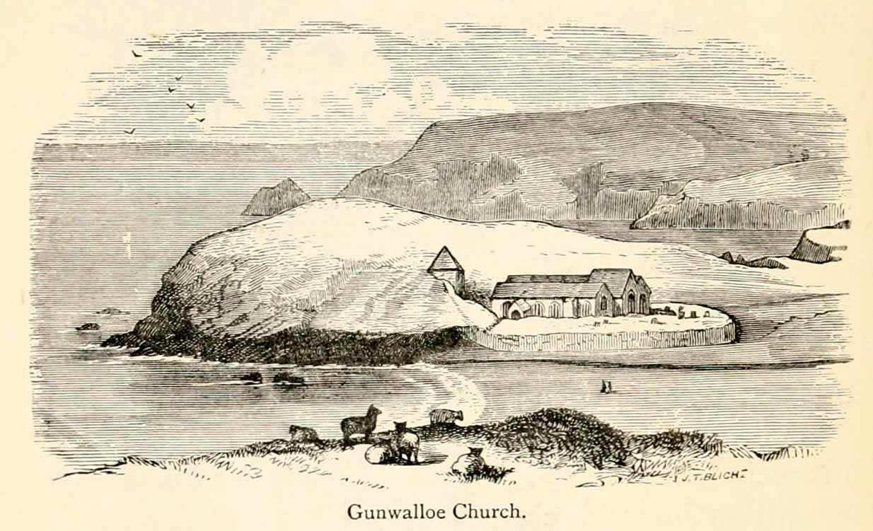
Holy Well (lost): OS Grid Reference – SW 6602 2053
Archaeology & History
The old church at this headland just above the sea was, said Padel (1988), dedicated to Saint Gunwalloe or Winwalloe in 1332 and is thought to have been the character (a hermit by all accounts) who deemed this well to be ‘holy’. In Alfred Cummings (1875) history of Gunwalloe parish, he devotes a short but singular chapter to this holy well which, according to most accounts, has fallen back to Earth. It was found, said Cummings, “close to the church porch, only a few feet over the precipitous rock…and (was) doubtless the resort in former days of many a lad and maiden.”
Yet even in his day, he lamented its loss, telling that.
“The spring that once bubbled up in its rocky basin is no longer there; sand and stones fill up the well at each high tide, and though occasionally cleaned out for the satisfaction of the wayfarer’s curiosity is yet only an imperfect semblance of its former self.”
Yet remnants of practices and traditions of the well were thankfully remembered:
Gunwalloe church in 1885
“That Gunwalloe was considered by the country folk a well of some importance there can be little doubt, for one day in the year, which was called Gunwalloe Day, was set apart for cleaning out this holy well — it was quite at a different time of year to this parish feast — and now only remembered by two old men out of the whole population of the place.
“They fix the time in their memories as the period of tilling barley, for they recollect that on this Gunwalloe Day it was the custom for the men to mend all the cliff roads (doubtless these were useful in days of smuggling when a successful run was a desirable thing), and so strictly was it kept that, if any were found labouring in the fields, a party would go and take them by force, and press them into the service of the holiday makers, who, having mended the roads and cleared the holy well at Gunwalloe, wound up the day with merriment and revelry.”
Such practices are long since gone of course and, so most modern accounts would tell us, the holy well with it. But when J. Meyrick (1982) came looking for the site on the summer solstice of 1980, he seemed a little more fortunate than his predecessors. Located just a few yards from the detached church tower, he spoke with a
“Mrs Wilson, a churchwarden (who) told me that in heavy rain the tower continues to be flooded so the spring is still somewhere about, and curiously enough by the stile to the beach is a small granite trough with rainwater put there by someone no doubt in lieu of the Well and who is to say that the water is not holy! The stream across the dune still meanders a few feet beneath the tower and into this the water from the well would have run, but there seems now no sign of an originating spring in the rocks around.”
Folklore
The church itself possesses a folktale found up and down the land. “It is said,” wrote Blight (1885),
“that the builders intended to erect the church on higher ground, nearer the centre of the parish, at Hingey; but as fast as materials were brought to the place they were, by some mysterious agency, removed during the night to the present site. And here the church was built, it being found useless to contend with a supernatural power.”
The supernatural agencies that are nearly always responsible for such actions tend to be the devil, fairies or other types of little-people.
References:
Blight, J.T., Churches of West Cornwall, Parker: London 1885.
Holy Well (destroyed): OS Grid Reference – TQ 332 911
Also Known as:
My Lady’s Hole
Archaeology & History
Long since gone after drainage operations on Tottenham Cemetery made the waters dry-up, this was one of several holy wells in the Tottenham area. Its history has been described in various old tomes, but the most definitive is found in William Robinson’s (1840) classic on the parish of Tottenham, when the well was still visible. He told us:
“There is a spring which issues from the side of a small hillock on the south side of the Moselle, nearly opposite the Vicarage, leading thence to the Church, called Bishop’s Well. This spring was formerly considered famous for many strange and wonderful cures performed on the diseased by the use of this water. It has been for some years neglected, but of late the owner of the field in which this well is, had it cleansed, and planted some trees round it, and put up posts and rails to prevent the cattle treading down the sides of it. It is said that the water of this well never freezes. In former times this well was in great repute from the purity of its water. The ladies in the vicinity of it were accustomed to send their servants in the morning and evening for water for their tea, from which circumstance it was for many years known by the name of “My Lady’s Hole.” The water of this well is not only esteemed for its medicinal qualities, but particularly for curing disorders of the eye.
“There were formerly many other springs about the village, especially one which issued out of the hill on which the Church stands; and another in Spottons Wood otherwise Spottons Grove, on the north side of Lordship Lane, which in the fifteenth century was of considerable notoriety; but none of which have in former times been so much frequented and held in such repute as Bishop’s Well.”
(Please note: the grid-reference for this site is an approximation)
References:
Foord, Alfred Stanley, Springs, Streams and Spas of London: History and Association, T. Fisher Unwin: London 1910.
Hope, Robert Charles, Legendary Lore of the Holy Wells of England, Elliott Stock: London 1893.