Winterborne Came 18b, Bincombe, Dorset

Tumulus (destroyed):  OS Grid Reference SY 6800 8600

Also Known as:

  1. Monument No.1300126  (Pastscape)

Archaeology & History

Charles Warne's 1848 drawing of the old tumulus
Charles Warne’s 1848 drawing of the old tumulus

A number of very large prehistoric burial mounds, or tumuli, were destroyed in this part of Dorset in the 19th century, including “three on the Came estate, near Dorchester, the property of the Hon Col. Damer.” This one—listed as a “bowl barrow” and known today as the Winterborne Came 18b tumulus in Grinsell’s (1959:148) brilliant survey—was found to house examples of petroglyphs, which are very rare in this part of Britain.  Thankfully before its destruction, the local antiquarian Charles Warne (1848) was present and has left us with a good description of its structure and contents.  After first telling of the demise of two other large tumuli close by, the biggest of them drew his attention:

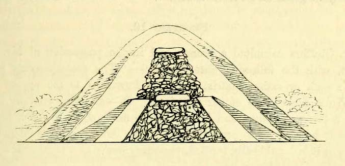
“The last of these mighty mounds (and well do they merit the appellation from their vastness), measured rather more than ninety feet in diameter, and sixteen feet in height; this from the peculiarity of its contents was the most interesting of the three. The annexed rough sketch (above), shewing a central section of the tumulus, may serve to give some idea of the singularity of its composition. About the centre, at a depth of some three feet from the surface, was found lying flat a rough unhewn stone, with a series of concentric circles incised; this, on being removed, was seen to have covered a mass of flints from six to seven feet in thickness, which being also removed we came to another unhewn irregular stone, with similar circles inscribed, and as in the preceding case, covering another cairn of flints, in quantity about the same as beneath the first stone. It was in this lower mass that the deposits were found, consisting of all the fragments of an urn of coarse fabric, and apparently as if placed in its situation without either care or attention, no arrangement of the flints being made (as we have elsewhere seen) for its protection; the want of which observance had completed its destruction.  Under the flints, lying at the base, were the remains of six skeletons, and some few bones of the ox. The skeletons had apparently been placed without order or regularity: with the exception of a few bits of charcoal with the urn, there was no evidence of cremation.”

Nearly twenty years later, Sir James Simpson (1867) also described the tumulus and its carved rocks in his 19th century magnum opus, repeating much of Warne’s earlier description, saying:

“In his antiquarian researches in this county (Dorset), Mr Warne opened , at Came Down on the Ridgeway, a tumulus of rather unusual form. At its base…were found the remains of six unburnt human skeletons…and some few bones of the ox.  Above them, and in the centre of the tumulus, was built up a cairn or heap of flints around a coarse and broken urn, which contained calcined bones.  This mass of flints was surrounded and covered by a horizontal rough slab.  Above and upon this slab was built another large heap of flints, six or seven feet in thickness.  This second heap was capped with another rough slab, lying two or three feet below the surface of the tumulus.  Both these flat unhewn covering slabs had a group of concentric circles cut upon them.”

We don’t know for sure the exact whereabouts of the tumulus, nor the age of the tomb and its remains.  But the size of it may indicate an early Bronze Age and perhaps even neolithic status. The finding of the rock art in the tomb is also an indicator that could push the date back into late neolithic period—but we may never know for sure…

References:

  1. Grinsell, Leslie V., Dorset Barrows, Dorset Natural History & Archaeological Society 1959.
  2. Royal Commission on Historical Monuments (England), An Inventory of Historical Monuments in the County of Dorset – Volume 2: South-East, HMSO: London 1970.
  3. Simpson, James, Archaic Sculpturings of Cups, Circles, etc., Upon Stones and Rocks in Scotland, England and other Countries, Edmonston & Douglas: Edinburgh 1867.
  4. Warne, Charles, “Removal of Three of the Large Tumuli on the Came Estate, near Dorchester,” in Journal of the British Archaeological Association, volume 3, 1848.
  5. Warne, Charles, The Celtic tumuli of Dorset: An Account of Personal and other Researches in the Sepulchral Mounds of the Durotriges, J.R. Smith: London 1866

© Paul Bennett, The Northern Antiquarian 


East Riddlesden Cross, Keighley, West Yorkshire

Cross:  OS Grid Reference – SE 079 421

Archaeology & History

A little-known early christian relic found in the driveway to East Riddlesden Hall was saved and propped up in the stable floor at the back.  In 1984 however, the National Trust got round to moving it and bringing the relic to greater public attention by putting it on display in the great hall of the building. (I think you’ve gotta pay to go in and see the stone these days – which is a bittova pain if you just want to examine the carving)

Old photo of the carved stone (after Margaret Faull)

Measuring just 1 foot across and 2 feet high and carved on all sides, the design is all too familiar to those of you exploring early christian or late-Celtic art forms.  Executed sometime between the 5th-10th century, on the main face of the cross we have the traditional ‘Celtic’ interlacing, with a bird-figure emerging on or around an early ‘cross’ symbol.  There are a variety of interpretations of this, but none relate to any modern christian mythic structures.  Indeed, we should cautiously reflect on the more pre-christian nature of this design: carved as it was at a time when the spirit of the natural world (animism) was endemic amongst all people.  This carving would in some way reflect such implicit subjectivity, though perhaps have had emergent ideals relevant to the christian cult within it.  However, we should be cautious about this christian idea, despite it being much in vogue by prevailing groups of consensus trance historians.

References:

  1. Faull, Margaret L., “The Display of the Anglo-Saxon Crosses of the Keighley Area,” in Transactions of the Ancient Monuments Society, New Series no.30, 1986.

© Paul Bennett, The Northern Antiquarian


Crook Farm (north), Baildon Moor, West Yorkshire

Cup-and-Ring Stone:  OS Grid Reference – SE 13703 39616

Getting Here

Crook Farm North CnR

Take the road up alongside and past Shipley Glen, taking the turn to go to Crook Farm caravan site. Go right to the very end of the car-park, then walk up the footpath through the trees on your left.  Keep going uphill about 100 yards by the field-wall until the land begins to level out – and shortly before the first gate into the field (on your right) keep your eyes peeled for the triangular stone in the ground, barely 10 yards away from the walling.  Alternatively, from the entrance into the Dobrudden caravan park walk to the far-end of the level area in front of the little cafe and walk along the footpath that crosses the grassland to the walling nearly 300 yards away (south).  Follow the wall down below the gate and zigzag about. You’re damn close!

Archaeology & History

Crook Farm north carving

For some reason this has always been one of my favourite cup-and-ring stones on Baildon Moor and it’s well worth checking out if you visit the area!  It was rediscovered by the Bradford historian W.E. Preston, who photographed the carving around 1912.  Shortly afterwards he took fellow historians Joseph Rycroft and W. Paley Baildon to see this (and others he’d located) and subsequently both a drawing and Mr Preston’s photo of the site was included in Mr Baildon’s (1913) magnum opus the following year.

As you can see from the relative photos—with literally 100 years between them—erosion hasn’t taken too much toll and this neolithic or Bronze Age carving remains in very good condition.

Rycroft’s early drawing
Preston’s 1912 photo

Covered with upwards of fifty cup-markings, there are also two cup-and-rings and numerous carved lines meandering around and enclosing some of the many cups.  One cup-mark was cut into the narrow end or ‘nose’ of the stone.

It’s a fascinating design, with another ‘Cassiopeia’ cluster of cups in one section, beloved of archaeoastronomers who explore these stones.  Mr Rycroft’s drawing of the design (left) is perhaps the best one, to date.

Along this same ridge there are remains of other prehistoric sites, more cup-and-rings, remains of prehistoric walling and what may be a small cairn circle (to be described later).

References:

  1. Baildon, W. Paley, Baildon and the Baildons – parts 1-15, Adelphi: London 1913-1926.
  2. Bennett, Paul, Of Cups and Rings and Things, unpublished: Shipley 1981.
  3. Bennett, Paul, Megalithic Ramblings between Ilkley and Baildon, unpublished: Shipley 1982.

© Paul Bennett, The Northern Antiquarian


Came Down Carving, Winterborne Came, Bincombe, Dorset

Cup-and-Ring Stone:  OS Grid Reference – SY 6800 8601

Also Known as:

  1.  Winterborne Came 18b Carving (Grinsell)

Archaeology & History

Charles Warne's 1848 drawing of the old tumulus
Charles Warne’s 1848 drawing of the old tumulus

On January 27, 1848, the great Dorsetshire antiquarian Charles Warne sent a letter to the British Archaeological Association about a series of three large tumuli he’d explored south of Dorchester in Dorset, within which he’d found some fascinating remains. And in what he called “the last of these mighty mounds (and well do they merit the appellation from their vastness),” which “measured rather more than ninety feet in diameter, and sixteen feet in height,” the most intriguing remains emerged. In the middle of what L.V. Grinsell (1959) catalogued as the Winterborne Came 18b tumulus, Mr Warne told:

“About the centre, at a depth of some three feet from the surface, was found lying flat a rough unhewn stone, with a series of concentric circles incised; this, on being removed, was seen to have covered a mass of flints from six to seven feet in thickness, which being also removed we came to another unhewn irregular stone, with similar circles inscribed, and as in the preceding case, covering another cairn of flints, in quantity about the same as beneath the first stone.”

“…It will be seen that the most singular feature connected with this tumulus, is that of the incised stones: examples of which I am not aware have before been met with in like situations. It may be as well to forego any attempt at an elucidation, which must be purely hypothetical; but it seems more reasonable to believe that they bore some mystic reference, rather than that they were the unmeaning amusement of some Celtic idler.”

One of 2 carved stones found in the tumulus

Sir James Simpson (1867) described these carved stones in his 19th century magnum opus, giving an early illustration of one of them, as shown here.  You’ll note that the carving is devoid of any central ‘cup’ as commonly found, consisting simply of a mere series of concentric rings.

If anyone knows the whereabouts of this and its companion stone today, it would be good to see them.  Are they kept in some local museum?

References:

  1. Grinsell, Leslie V., Dorset Barrows, Dorset Natural History & Archaeological Society 1959.
  2. Royal Commission on Historical Monuments (England), An Inventory of Historical Monuments in the County of Dorset – Volume 2: South-East, HMSO: London 1970.
  3. Simpson, James, Archaic Sculpturings of Cups, Circles, etc., Upon Stones and Rocks in Scotland, England and other Countries, Edmonston & Douglas: Edinburgh 1867.
  4. Warne, Charles, “Removal of Three of the Large Tumuli on the Came Estate, near Dorchester,” in Journal of the British Archaeological Association, volume 3, 1848.

© Paul Bennett, The Northern Antiquarian


Nottingham Hill Carving, Gotherington, Gloucestershire

Cup-and-Ring Stone:  OS Grid Reference – SO 9875 2825

Archaeology & History

Nottingham Hill cup-and-ring

A rare find this!  In October 1981, in deepest Gloucestershire on the edge of the Nottingham Hill Iron Age hillfort, archaeologists sifting through what they ostensibly called “occupational debris” along the western edge of the huge enclosed monument, found a singular piece of local oolitic limestone etched with an archetypal cup-and-ring design!  The carving was on a typical ‘portable’ piece of stone and would not have been amiss had it been uncovered in a neolithic or Bronze Age cairn in our more northern climes.  But this southern example is something of an anomaly.

In Morris & Marshall’s (1983) description of the stone they told how,

“it was found as a loose block lying with the worked surface uppermost, and half-embedded in the plough-soil, together with other slabs and irregular lumps of oolitic limestone of similar size, and of closely related rock-type.  The object is a discreet slab with an unworked under-surface weathered by percolation of ground-water along a joint.”

Drawing of the carving

They found that the carved stone was typical of other rocks making up the ramparts at the outer-edges of the hillfort, and at some point in its history may possibly having been included in the walled structures of the fortress itself.  However, this is unlikely to have been the original use of the carving.  Its inclusion in the Iron Age ramparts would more be a likely consequence of it being appropriated from another, much earlier archaeological site in the area — a chambered tomb or long barrow for example.  This re-use of cup-marked stones in the Cotswolds is known to have occurred in the village of Salford, on the church cross-base, 18.75 miles (30.2km) east of here.

The Nottingham Hill cup-and-ring was described in some detail by Morris & Marshall (1983).  The rock on which it was carved measured one square-foot in size and barely 3 inches thick.  The central cup-mark measured,

“approximately 15.5cm in diameter, and a shallow radial groove (channel 1) leads from it to the edge of the stone.  The central cup-mark is surrounded close to its lip by a penannular channel or ‘ring’ (channel 2), which has a small depression at one end.  This end of channel 2 appears to be discontinuous with channel 1, but there is a very lightly pecked connection at the other end.  Outside channel 2 is a second shallower ring or channel (channel 3) but because of its shallowness it is difficult to determine whether it links with the radial channel 1.  Channel 3 contains a clear, small cup-mark part-way along its length, and is quite definite on one side of the central cup-mark, and on the other side it is possibly mirrored by a rather indistinct depression or cup-mark and length of channel.  Channel 3 is not continuous throughout its length, ending where it meets the edge of the stone beyond the small cup-marks.”

It is obvious that the carving, whenever it was made, was not subjected to long-term exposure to the outside air, as the carved design would have eroded quite quickly on the oolitic limestone.

References:

  1. Morris, Ronald W.B. & Marshall, Alistair, “A Cup and Ring Marked Stone from Nottingham Hill, Gotherington,” in Bristol & Gloucestershire Archaeological Society Transactions, volume 101, 1983.
  2. Royal Commission on Historical Monuments, England, Ancient and Historical Monuments in the County of Gloucester: Volume 1 – Iron Age and Romano-British Monuments in the Gloucestershire Cotswolds, HMSO: London 1976.

© Paul Bennett, The Northern Antiquarian


Slade Cairnfield, Blubberhouses Moor, North Yorkshire

Cairnfield:  OS Grid Reference – SE 141 543

Getting Here

One of several recently discovered small cairns

Follow the same directions to reach the recently discovered Slade-02 carving; and simply walk 30 yards southwest.  The scattered ruins of numerous small stone piles, visible only when the heather’s been burnt back, is what you need to be looking for.

Archaeology & History

First discovered on a Northern Antiquarian outing in July 2011, it’s difficult to give an accurate appraisal of this site as much of the landscape all round here is very overgrown in deep heather.   Added to this, there is evidence of more recent medieval and post-medieval industrial activity that’s intruded and/or affected the earlier prehistoric remains that are evident here.  But these factors aside, we can say with certainty that here is a previously unrecognized prehistoric cairnfield — and it may be of some considerable size.

Ruined hut or cairn circle

We have so far located at least seven individual cairns and a cairn circle in relative proximity to each other, thanks to local rangers burning back the heather.  It was the discovery of the cairns which then led to the discovery of the nearby cup-and-ring stones.  Amidst the cairn-spoils there are also distinctive lines of stone, indicative of either walling or embankments of some form or another.  Some of the stone making up this cairnfield appears to have been robbed. We also found that in walking through the deeper heather surrounding this ‘opening’ (where it had been burned away a few months previously), a number of other man-made piles of stone were evident that seemed to indicate more cairns.  There is also evidence of further lines of prehistoric walling, whose precise nature is as yet unknown. But we do know that people have been on this moorland since Mesolithic times (structural and other remains of which are still evident less than a half-mile away).

The site requires greater attention the next time the heather’s been burnt back.

References:

  1. Davies, J., “A Mesolithic Site on Blubberhouses Moor, Wharfedale,” in Yorkshire Archaeological Journal, part 161 (volume 41), 1963.

© Paul Bennett, The Northern Antiquarian


Badbury Barrow Carving, Shapwick, Dorset

Cup-Marked Stone:  OS Grid Reference – ST 9583 0294

Also Known as

  1. Badbury Rings Carving
  2. Shapwick 6a carving

Archaeology & History

Badbury Barrow carving (after J.F.S. Stone 1958)

Amidst what was once a veritable gathering of prehistoric tombs on the ground immediately west of the Badbury Rings hillfort — a small necropolis no less! — one particular tumulus which Leslie Grinsell named as ‘Shapwick 6a‘ was in the process of being destroyed at the end of October, 1845, but was fortunate in receiving the quick attention of a local historian called John Austen, who gave us the first known account of the place. (a fuller profile of the Badbury Barrow can be found here)  Inside the churned-up remains of Badbury Barrow, which measured 62 feet across and 9 feet high, Mr Austin found a fascinating number of urns and other remains and, shortly after, this rare example of a petroglyph was identified.  The stone now lives in the British Museum where, the last I knew, you could certainly check it out.  But it’s not its original size, as sections of the stone were broken off.  As Aubrey Burl (1987) told us, the stone was originally about half-a-ton in weight, on which,

“were carvings of five cupmarks, two bronze daggers and two flat, triangular axes of early Breton type.”

Grinsell’s more detailed description of the carving from his work on Dorset Barrows (1959) tells a little more of the design found on this seeming ‘tomb-stone’:

“Sandstone slab, probably from stone cist, decorated with pecked carvings of two daggers with hilts, resembling those on stone 53 at Stonehenge; two triangular objects probably intended to be flat bronze axe-heads expanding at their cutting-edge; and five cup-shaped hollows.  The existing decorated fragment (in British Museum) is 1ft 10in long, and was detached from the original slab which weighed probably more than half a ton.  The size suggests, perhaps, a cover-slab.”

It may well have been.  Certainly it had some relationship to death!  The design was suggested in the 19th century to perhaps have been influenced by Greek imagery, when such notions were in vogue.  As Grinsell tells,

“In the centre according to Durden…was the well-known large slab of sandstone which was decorated with carvings of daggers and axes, the former of type similar to those from Stonehenge, conjectured to be of Mycenean type.”

But the Mycenean nature of the carvings is highly unlikely.  What is intriguing with this carving is the appearance of cup-markings (commonly associated in or adjacent to prehistoric tombs) alongside defined symbols of daggers.  We could infer a magickal relationship between the two symbols here: one of which, the cups, comes from a much earlier period than the dagger-design.  A more in-depth analysis of the human remains within the tumulus and a plan of the site would perhaps be more revealing…

…to be continued…

References:

  1. Austen, John H., “Archaeological Intelligence,” in Archaeological Journal, volume 3, 1846.
  2. Burl, Aubrey, The Stonehenge People, Guild: London 1987.
  3. Grinsell, Leslie V., Dorset Barrows, Dorset Natural History & Archaeological Society 1959.
  4. Knight, Peter, Ancient Stones of Dorset, Power: Ferndown 1996.
  5. Royal Commission on Historical Monuments, England, An Inventory of the Historical Monuments in the County of Dorset – Volume 5: East Dorset, HMSO: London 1975.
  6. Stone, J.F.S., Wessex Before the Celts, Thames & Hudson: London 1958.
  7. Warne, Charles, The Celtic Tumuli of Dorset, John Russell Smith: London 1866.

© Paul Bennett, The Northern Antiquarian


Panorama Stone (226), Ilkley Moor, West Yorkshire

Cup-and-Ring Stone (lost):  OS Grid Reference – SE 1015 4702

Also Known as:

  1. Panorama Rock 226

Archaeology & History

J.R. Allen’s 1879 drawing

It would seem that this excellent looking cup-and-ring stone may have been destroyed sometime around 1890 during the construction of the Panorama Reservoir and the building of the houses on the southwestern edge of Ilkley, right by the moorside.  But this isn’t known for certain; and the carving could still exist beneath vegetation in the trees just north of the reservoir.  In requesting to explore some National Archives data in which there may be information relating to this carving (and others nearby), I was directed to Bradford Council’s community archaeologist, Gavin Edwards (to whom requests should be made), but he denied access to look at the files, then completely ignored subsequent queries that might enable us to locate this and other important prehistoric carvings.  So we did our best and this is what we’ve found so far (forgive any errors).

As there’s a slight ambiguity in the precise location of this lost carving, we cannot say for certain whether or not this site was included in the sale of Property Lots, numbers 7-34, “surrounding the far-famed Panorama Rocks,” which may have led to the site’s destruction and subsequent removal of the protected Panorama Stones to Saint Margaret’s Park on the other side of the road from the church, closer to Ilkley centre.  The sale of this “building land” as it was called was advertised in the Leeds Mercury, Saturday September 4, 1880, with a brief description of the respective “lots” near this and the adjacent carvings.  But this Panorama Stone 226 may have been left alone and be buried under the surface…

J.T. Dale’s 1880 sketch

Historical notes on this particular stone are scattered and sparse, but digging through old journals and texts has given us a reasonably good vision of the place.  It was first described, albeit in passing, in A.W. Morant’s edited third edition of Whitaker’s History of Craven (1878: 289), where it was described in context with the other cup-and-ring east of here on the same ridge.  All of them were described as being located within a now-destroyed prehistoric enclosure (precise nature unknown), with carving 226 at the westernmost end.  However, the following year J. Romilly Allen (1879) gave more details of this, “the third stone” as he called it and furnished us with a damn good drawing to boot!

As we can see, there are four double-ringed cups and eight or nine archetypal cup-and-rings, with the usual scatter of cups falling across the design.  The curious ‘ladder’ markings found on one of the other Panorama Stones, the Barmishaw Stone, Willy Hall’s Wood carving and at least one of the Baildon Moor carvings, were also quite prominent.  Although when J. Thornton Dale visited here around the same time and did his own drawings, the ladders weren’t quite as pronounced.  This would have been due to the simple factors of cloud cover, poorer sunlight and the time of day the drawings were done (the pseudoscientific proclamation of local archaeologist Gavin Edwards that such artistic difference is due to some Victorian chap adding, or removing sections of the carvings for his own pleasure, negates common sense and is strongly lacking in evidence).  Romilly Allen’s own description of the site was as follows:

“The Panorama Rock lies one mile south-west of Ilkley, and from a height of 800 feet… About 100 yards to the west of this spot appears to be some kind of rough inclosure, formed of low walls of loose stones, and within it are the three finest sculptured stones near Ilkley. They lie almost in a straight line East to West… The third and most westerly stone of the group measures 10ft. by 9ft. and lies almost horizontally, having its face slightly inclined. On it are carved twenty-seven cups, fourteen of which have concentric rings round them. Some of the cups have connecting grooves, and three have the ladder-shaped pattern before referred to.”

Notes from a few years later told that this carving was still in situ when the companion carvings were moved and imprisoned behind railings across from St. Margaret’s Church in Ilkley.   The carving was shown at the grid reference given above on the 1895 Ordnance Survey map of the region before the reservoir was built, correcting the coordinates given in Boughey & Vickerman’s (2003) otherwise fine survey.  They described this very ornate carving thus:

“According to Thornton Dale (1880), this was a large rock with 27 cup, eighteen of which had single rings.  Some of the cups had connecting grooves and three had the same ladder motif as the Panorama Stone.”

…to be continued…

References:

  1. Allen, J. Romilly, “The Prehistoric Rock Sculptures of Ilkley,” in Journal of the British Archaeological Association, volume 35, 1879.
  2. Allen, J. Romilly, “Notice of Sculptured Rocks near Ilkley,” in Journal of the British Archaeological Association, volume 38, 1882.
  3. Allen, J. Romilly, “Cup and Ring Sculptures on Ilkley Moor,” in The Reliquary, volume 2, 1896.
  4. Bennett, Paul, The Panorama Stones, Ilkley, TNA: Yorkshire 2012.
  5. Boughey, Keith, “The Panorama Stones,” in Prehistory Research Section Bulletin, no.40, Yorkshire Archaeological Society: Leeds 2003.
  6. Boughey, K.J.S. & Vickerman, E.A., Prehistoric Rock Art of the West Riding, WYAS: Leeds 2003.
  7. Collyer, Robert & Turner, J.H., Ilkley: Ancient and Modern, William Walker: Otley 1885.
  8. Jennings, Hargrove, Archaic Rock Inscriptions, A.Reader: London 1891.
  9. Turner, J. Horsfall, “British or Prehistoric Remains,” in Collyer & Turner, Otley 1885.
  10. Whitaker, Thomas Dunham, The History and Antiquities of the Deanery of Craven in the County of York, (3rd edition) Joseph Dodgson: Leeds 1878.

© Paul Bennett, The Northern Antiquarian


Eller Edge (429), Pock Stones Moor, Thruscross, North Yorkshire

Cup-Marked Stone:  OS Grid Reference – SE 0902 6150

Also Known as:

  1. Carving no.429 (Boughey & Vickerman)
Eller Edge stone 429

Getting Here

A slight walk to get here.  Follow the same directions as if you’re going to the Eller Edge 431 carving.  Once here, walk west as if you’re going into the middle of the field, keeping your eyes peeled about 20 yards along for a small-ish rounded stone with nice colours of lichen amidst the grasses.  If you’re patient, you’ll find it soon enough!

Archaeology & History

This is another simple cup-marked stone on the grassland ridge overlooking higher Wharfedale.  The carving here is a little clearer and more well-defined than that of its close neighbours, with a number of simple cups visible on its rounded surface.  We counted seven such cups on our cloudy-day visit, but Boughey & Vickerman (2003) thought there might be a little more, describing the stone simply:

from another angle
B & V’s drawing

“Small lichen-covered rough grit rock.  About eight cups and two depressions.”

A rubbing of this small stone (as practiced by English Heritage and rock art students alike) would prove useful in bringing out any other ingredients in the ancient design.  And whilst you’re in this field, have a look at the curious Spiral Stone and some of the other cup-markings close by.

References:

  1. Boughey, Keith & Vickerman, E.A., Prehistoric Rock Art of the West Riding, WYAS: Wakefield 2003.

Links:

  1. Eller Edge Rock Art – more notes & images

© Paul Bennett, The Northern Antiquarian


Eller Edge (424), Pock Stones Moor, Thruscross, North Yorkshire

Cup-Marked Stone:  OS Grid Reference – SE 08973 61487

Also Known as:

  1. Carving no.424 (Boughey & Vickerman)
Eller Edge carving 424

Archaeology & History

A slight walk to get here, but well worth it once you arrive!  Follow the same directions as if you’re going to the Eller Edge 426 carving.  Once you reach this stone, notice the larger rounded rock about 20 yards to your west, a bit further down the field.  You can’t really miss it!

Archaeology & History

A large rounded stone just on the meadows before it begins to slope more steeply downhill, there are several of those large natural ‘bowls’ that we see on a lot of cup-marked and not-so-cup-marked stones in our northern hills.  These basins or bowls may, at times, may have had significance for our ancestors, but it’s the cluster of cup-markings on this stone which are of importance to us here.  There are perhaps as many as a dozen cup-marks here, all very well worn, and mostly to be seen on the eastern sides of the rock.  When I came here with Paul Hornby and QDanT a few months back, the cloud cover stayed with us all day, so I didn’t get any decent images of the carving.  Ne’er mind…

Close-up of faint cups

The stone was described by Boughey & Vickerman (2003) simply as:

“Very large, uneven, rough grit rock with face with scooped-out areas sloping down to grass.  Eleven possible cups and six basins.”

A plain carving, perhaps only of interest to the fanatics amongst you.  But if you do visit here, check out carving 432, 431, and others in the same field.

References:

  1. Boughey, Keith & Vickerman, E.A., Prehistoric Rock Art of the West Riding, WYAS: Wakefield 2003.

Links:

  1. Eller Edge Rock Art – more notes & images

© Paul Bennett, The Northern Antiquarian