From Bettyhill village, take the A836 road west, down the hill from the village. Just before crossing the metal bridge over the River Naver at the bottom, go down the tiny road on the left. A mile or so along, go past the small loch by the roadside for another few hundred yards until you reach a quarry on the right. From here, cross the road and walk along the track towards the impressive Allt a’ Chaisteal Broch up the gorge. About 100 yards above this, on the south-side of the fence, keep your eyes peeled for two small standing stones. You’ll find ‘em!
Archaeology & History
There seems to be no previous mention of this site in any of the archaeology records. We were fortunate in venturing upon the place when Aisha, Lara and I were doing a typically circuitous meander to what I call the ‘Queen’s Cairn‘ of Strathnaver, above Skelpick Long.
The southernmost stones
The site on its raised platform
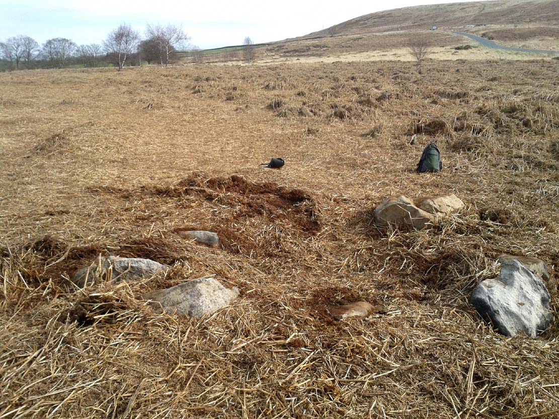
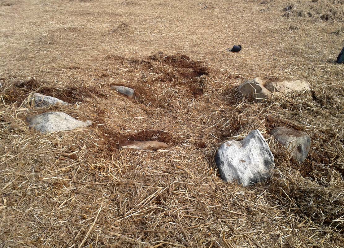
Approximately 10 yards in diameter, a raised platform 2-3 feet high consisting of thousands of small rocks in a roughly circular formation, is set on the edge of a slope above the Allt a’ Chaisteal Burn. Two small upright standing stones are set near the southern edge of the platform, with a third on the northwestern bank of rubble, leaning or fallen into the stone mass. A fourth stone to the northeastern edge is almost covered in rubble.
When we found the site, much of the heather had been burned away; if this had not been done, the site would not have been visible. Even with this however, accurate visibility was troublesome as the heather had began to grow back and the infestation of bracken was raising its tick-infested fronds.
Close-up of the southern stones
The site seems to be a good example of what Aubrey Burl (1988) calls a “four poster stone circle” – a number of which seem to be architectural ritual developments between cairns and stone circles. It exists within the immense Strathnaver prehistoric complex – a literal ‘Valley of the Kings’ – where dozens of large cairns, and a number of immense megalithic tombs exist. It is very similar in size and lay-out to the recognized four-posters at Druid’s Altar in Yorkshire, the Glenshervie Burn in Glen Almond, etc. It seems in relative isolation from other four-posters, the nearest known one being at Balnakeil (which Burl terms as being “uncertain”), more than 20 miles west of here; and the next being the Aberscross site some 35 miles away. However, the remote landscape would explain its seeming isolation, as many more prehistoric sites remain unrecorded in the area.
References:
Burl, Aubrey, Four Posters: Bronze Age Stone Circles of Western Europe, BAR 195: Oxford 1988.
Acknowledgements: Huge thanks to the big heart of Aisha Domleo – and her sproglett Lara – for gerrin us up here, enabling its rediscovery.
A recent visit to try find this intricate carving—the only one of its kind in Clackmannanshire—proved unsuccessful, and so I add it here in the hope that someone might know where it is and bring it back to light. It looked like quite an impressive petroglyph. If the stone isn’t hiding in undergrowth at the edge of someone’s garden, it may well have been destroyed—which would be appalling. As a unique design, this important carving should have been preserved. Even when the Victorian explorers found it, the covering stone circle had been greatly damaged and many stones in the ring had been removed. This carved stone remained intact however. When Mr R. Robertson (1895) and his friend visited the site, it was covered in sand and dirt and had fallen to the side of an internal cist:
“On clearing this away a remarkable feature was brought to light. The block was found to be elaborately ornamented on its sides and upper surface, with rings, spirals and lines. The labour of cutting these in the hard granite with primitive tools of the period must have been very great. Several successful photos of the stone and its carvings were taken by Provost Westwood, Dollar…. This stone has now been removed to the vicinity of Tillicoultry for safety.”
In the same article, George Black told slightly more of the design:
“The covering stone of the cist…bears on the face a series of concentric circles, and spirals springing from one of the groups of circles, Four grooves also unite the same set of circles with the left-hand edge of the stone. On the edge shown in the photograph there is another group, consisting of two concentric circles. The unevenness of the surface of the stone appears to have been of no moment to the sculptor of the circles, as the incisions follow the surface into its sinuosities and depressions.”
Not long after Robertson & Black’s visit, the great megalithomaniac Fred Coles (1899) came here—and he found that the “spirals” that Mr Black described were nothing of the sort.
“The huge irregularly-shaped diorite boulder which covered the cist has several cup-and-ring marks on one face and one side…. These marks are now, so I was informed when inspecting them, very much less distinct than they were when the photograph was taken (above) in 1894. It would be difficult now to describe the incised markings with accuracy; it is difficult even to see them when wet. But…I must take exception to the term ‘spirals’ as applied to any of these ‘rings.’ There are three groups of rings so placed as to make the outermost ring in each group touch that of the others (not an uncommon form), but there is no one true volute.
“…What is more noteworthy is the group of four long parallel, nearly perpendicular grooves issuing (probably) from the outermost ring of the group of five rings, and ending at the edge of the boulder.”
Alison Young’s 1937 sketch
Cole also noted that the carvings were to be found on the upper surface of the stone. It would seem very probable that the excessive erosion which Cole described was due to the fact that the stone was, many centuries earlier, exposed to the elements within the stone circle and not buried as it later came to be. It makes sense.
The excessive erosion was spoken of by the Royal Commission (1933) lads, aswell as the last person to describe the site, Ronald W.B. Morris (1981), who said that during his visits here between 1966-75,
“the author has only found traces of possible cups visible on the rough surface, which has flaked badly.”
Morris (1981) said that the stone measured “1½m by 1¾m by ½m (5½ft x 4½ft x 2ft)”—and was last known to be some 10 yards NW of the Tillicoultry House cottage, but we could locate no trace of the stone or its carving. If anyone is aware of the whereabouts or fate of this important neolithic carving, please let us know.
Morris, Ronald W.B., “The Cup-and-Ring and Similar Early Sculptures of Scotland; Part 2 – The Rest of Scotland except Kintyre,” in Transactions of the Ancient Monuments Society, volume 16, 1969.
Morris, Ronald W.B., The Prehistoric Rock Art of Southern Scotland, BAR: Oxford 1981.
From Kirriemuir central, head up the Kinnordy road, going straight across the main road and continuing past the Kinnordy turn-off for just over a mile towards Mearns, stopping where a small copse of trees appears on your left. From here, walk along the track to the west. It goes gradually uphill, cutting through a small cleft with a hillfort on the north and a cairn circle on the south until, ⅔-mile along, you reach the moorland. Keep going on the same path for another ½-mile west where the grasslands level out. Here, on the flat bit between the two hills, a small incomplete ring of stones lives, with one stone sticking out. You’ll find it!
Archaeology & History
This is a curious site on several levels—not least, that its definition as a ‘stone circle’ is a fragile one; although to be honest, we do find here a large unfinished arc of stones in what looks like either an unfinished ring, or a deliberately constructed large arc. But you won’t find it in the standard megalithic gazetteers of Burl, Barnatt or Thom as it was only relocated in the 1980s by local researchers Sherriff and MacKnight. (1985) They didn’t have much to say about it either, simply telling that they’d found,
“A stone setting representing the remains of either a denuded cairn or a stone circle lies in the saddle between Culhawk Hill and Castle Hill. One erect and 4 prone boulders describe a portion of a roughly circular site some 10m in diameter.”
Arc of fallen stones, looking NE
Faint low ring, looking W
This is roughly the gist of it, with the largest and most prominent of the stones—barely three feet tall—standing on the western side (this is the stone which draws your attention – otherwise you’d never even notice it). The rest of the stones seem to have been knocked down some time ago. A barely discernible embankment constructed around the edge of the ring can be seen around the northern side. It seems unlikely that it was a cairn, as no inner piles of stones were in evidence when we visited the site. It may be a large hut circle. But in truth it could do with an excavation so that we can suss out its exact nature. Beneath the grasses we found an additional stone to those counted by Sherriff & MacKnight; but more intriguing is what Frank Mercer and I found before we even reached the small circle….
Trackway leading to the circle
More visibly distinct than the ring itself were two artificial raised embankments, running parallel with each other 3-4 yards apart. The raised edges of these embankments were about a yard across, on both sides, with the inner area slightly lower than the outlying natural background. These distinct linear earthworks are, quite simply, an early medieval or prehistoric trackway—and it leads directly into the circle! It’s quite unmistakable and is clearly visible as it drops down the slope to the south and away into the fields below. Sadly when we found it last week, darkness was falling and so we didn’t trace the trackway any further. But the most notable thing was that it stopped at the circle and did not continue on its northern side, implying that it was constructed with the circle as its deliberate focal point. The trackway and its embankments are roughly the same size as other recognized prehistoric routes, such as Elkington’s Track on Ilkley Moor and the other ancient causeway that runs past the prehistoric ring known as Roms Law.
Regarding the ring of stones: unless you’re a real megalith fanatic, you’ll probably be disappointed by what you see here. It’s a bittova long wander to something that may once have been just a hut circle, but the avenue leading up to it is something else – and much more intriguing!
References:
Sherriff, John R. & MacKnight, O., “Culhawk Hill (Kirriemuir p): Stone Setting,” in Discovery & Excavation Scotland, 1985.
Acknowledgements: Thanks as always to Nina Harris and Frank Mercer; and to Paul Hornby for use of his photos.
In Mason Inglis’ (1888) fascinating history of the village of Auchterhouse, he describes a number of prehistoric antiquarian remains—some destroyed, others still in place. But this old ring of stones is another of our ancient monuments that has fallen in the wake of the Industrialists with their ‘progress’ and ecocide. Mr Inglis told,
“South of the Templelands another group of these mysterious circular stone relics of pagan times at one time stood, and was also held in much regard, and recognized as an ancient place of worship. This group, however, unfortunately was demolished during excavations for railway purposes.”
He goes on to describe the finding of other prehistoric tombs and “unhewn slabs…in regular rows and at equal distances apart” in the same area. It seems that many of these have also been destroyed.
Described by the early 20th century antiquarian and megalithomaniac Fred Coles (1903) as being situated “about 1¼ mile SE from the church at Ythan Wells,” all trace of this stone circle has long gone, and had already disappeared when Coles was surveying the region, telling merely that it had been here “in open fields.” All subsequent explorations looking for remains of the site has proven fruitless.
References:
Barnatt, John, Stone Circles of Britain – volume 2, British Archaeological Report: Oxford 1989.
From the double-ring that is the Brackenhall Circle at Shipley Glen, go up the road towards the hills and seek out the cup-marked Glovershaw Quarry Stone. Shortly before this, notice the small trees close the quarry edge. From here, walk straight east, as if you’re going toward Baildon Hill. Barely 10 yards into the bracken you’ll notice this small ring of stones (best looked for in winter before the bracken grows back – otherwise you’ve no chance!).
Archaeology & History
This site was explored when James Elkington, Paul Hornby and I came across it on Wednesday, 11 March 2015, after returning from a short excursion to look at some of the petroglyphs on Baildon Hill.
Ostensibly it is a small ring of stones comprising of at least 7 large rocks that are set deeply into the peat and bracken-mass, with a small eighth movable stone on the northern side. It seemed likely that another, larger rock was beneath this small portable rock, but we didn’t dig into the vegetative mound to explore this. The most curious thing about the ring of stones was that it measured barely 4 yards in diameter. My initial thought was that this was a previously unrecorded cairn, but there seemed to be no internal mass of rocks in the centre that characterize such monuments and which you’d expect in a ring of this size – meaning that it may be, perhaps, the smallest stone circle in Britain. It’s a pretty good contender at least! (the stone circle known as “Circle 275” at Penmaenmawr in Wales is of similar size to this one, but with less stones in that ring)
Close-up of the stones
It would be good if the regional archaeologists could give this site their attention and clean it up to see exactly what lays beneath the boscage. Close by are several cup-marked stones and a couple of other larger cairn circles.
The name of the site came after I almost stood on a hibernating toad, found beneath the bracken-mass right at the edge of one of the stones. I carefully picked him up and reburied him in another spot close by, leaving him (perhaps) to ponder his venture into the bright daylight of consciousness! Mr Hornby promptly declared – “these are the Toad Stones!” – and it stuck.
Stone Circle (destroyed): OS Grid Reference – SK 26 94
Archaeology & History
This lost ring of stones was one many sites that could once be found in this area. It was written about in John Watson’s (1776) essay on the local antiquities, where, in describing places he thought were druidical remains (like the prehistoric Bar Dike and Apronful of Stones cairn), he told that
“There is something also of this sort on the other side of Bardike on Bradfield Common; in particular a circle of about eight yards diameter composed of twelve stones, and a confused heap in the centre, near Handsome Cross, and the faint remains of two larger not far off.”
Subsequent local historians like Joseph Hunter (1819) and Harold Armitage (1939) mention the place, with Armitage giving the impression that remains of it could be seen in his lifetime, but today we are at a loss to known its exact position and nature. By the sound of Watson’s initial description, this circle sounded as if a cairn of some sort was in the centre, giving it more a funerary nature than an open stone circle. But we don’t know for certain. This is also what John Barnatt (1990) posited in his local survey.
Based on the landscape, an initial analysis would place the circle most probably at SK 2615 9424, close to where the Handsome Cross itself stood—but this is conjectural. The natural landscape hereby has been ruined by extensive farming and forestry, so any remains of it seem improbable.
References:
Armitage, Harold, Early Man in Hallamshire, Sampson Low: London 1939.
Barnatt, John, Stone Circles of Britain – volume 2, BAR: Oxford 1989.
Barnatt, John, The Henges, Stone Circles and Ringcairns of the Peak District, University of Sheffield 1990.
Hunter, Joseph, Hallamshire: The History and Topography of the Parish of Sheffield, Lackington: London 1819.
Morgan, Paul & Vicki, Rock around the Peak, Sigma 2001.
Smith, A.H., The Place-Names of the West Riding of Yorkshire– volume 1, Cambridge University Press 1961.
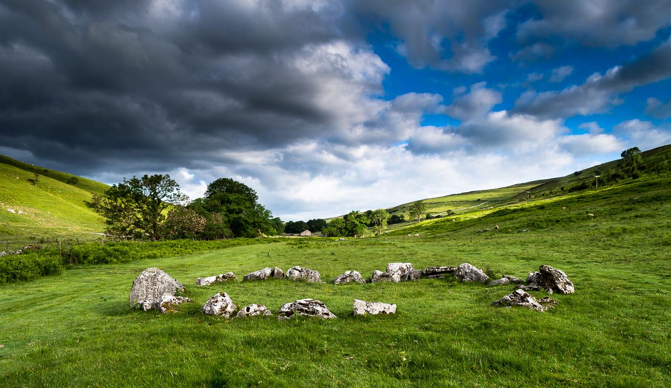
The long country road running between Aysgarth and Kettlewell is the B6160. Whether you’re coming from the north (Aysgarth) or south (Kettlewell), when you reach either Buckden or Cray, take the minor road west to Hubberholme. Just over 1½ miles further on, you reach the tiny hamlet of Yockenthwaite itself. Cross the river bridge, then turn left and walk along the footpath parallel with the river. 600 yards or so along, keep your eyes peeled for the low small ring of stones in front of you.
Archaeology & History
Just above the well-trod path that runs parallel with the usually shallow River Wharfe, this small and silent ring of stones rests in the idyllic host of Langstrothdale, deep in olde Yorkshire. Tis a wonderful spot… Classed as a ‘stone circle’ for many a decade (even by the esteemed Aubrey Burl), this small but ancient ring shouldn’t really be held in the same category as our larger megalithic circles. In truth, it looks more like some of the larger hut circles I’ve seen and uncovered down the decades—and it may well be that. Indeed, even the archaeo’s aren’t in agreement as to what it is, with the general idea being that it is the remains of a ring cairn of some type, despite no human remains being found here.
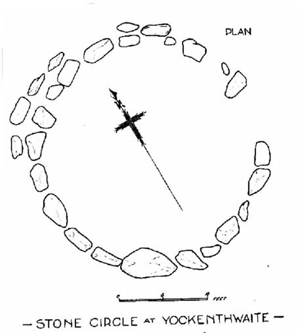
Raistrick’s 1929 planLooking northwest
Yockenthwaite itself was already know by this name in 1241 CE, when the monks of Fountains Abbey were given the land by one of the murderous invading Norman families of the period. This ingredient may be relevant to the history of the circle, for as the great northern antiquarian Harry Speight (1900) pointed out,
“in several places in the dales there are traces of what seems like ancient sheep or cattle enclosures, which are probably vestiges of this grant to the monks of Fountains in 1241.”
And Speight thought the circle had a similar origin to these remains. He continued:
“An enclosure of this kind, composed of a number of big stones on end, lies at the low end of the second pasture on the north side of the river between Yockenthwaite and Deepdale, and has been described as a Druid’s Circle. It is doubtless one of these monastic folds.”
And he may have a point. Although when Arthur Raistrick (1929) ventured here in the early 1920s, he had other ideas, pushing the date of the site way way back into the Bronze Age. “The circle,” Raistrick told,
“is slightly raised above the surrounding ground-level, and the stones, standing edge to edge, can be seen from a considerable distance on either fell side. The circle is 25 feet diameter, very nearly a true circle, there being only about 6 inches variation in diameter. The stones number 20, placed on edge to edge to edge…with only two small gaps, which would accommodate three or perhaps four more stones. These stones were probably removed some years ago to repair the stile in the neighbouring wall. Outside this circle of 20 stones, on the northwest side, there are four others placed concentrically, and very close to the circle, but there is no evidence that the circle was ever double, or that there were ever more than these extra four stones. There is a slight mound at the centre, and probing with a rod proved a small circle of stones, about 9 feet diameter at the centre, indicating probably a burial. Several large boulders lie on the level ground around the circle, but these are all rolled down from the fell-side above, and not placed in any connection with the circle. All the stones of the circle are of limestone…”
It was this designation that led to Burl (1976; 2000) to include it in his corpus of megalithic rings; although John Barnatt (1989) did question the validity of the site as a true ‘stone circle’ in his own gazetteer, saying:
“This unusual site comprises a contiguous ring of orthostats of c. 7.5m diameter, which are graded downslope to the SSW to allow for the gradient; their tops are all roughly horizontal. They range from 0.30 to 1.05m in height, 22-3 stones survive today and 3-4 appear to be missing. To the NNW there is a short outer arc of 4-5 stones placed immediately outside the main ring. 4 loose stones appear to have been added to the ring recently. Raistrick’s plan does not tally with the present remains, despite the sites undisturbed nature. The interior of the site is filled by a low horizontal platform, with virtually no height upslope to the north-east and a height of c. 0.5m to the south-west. The ring of stones stand well proud of this round the full circumference. This site appears to be a variant form of kerb-cairn rather than a true stone circle.”
The structure has been built onto a slight but notable platform, as has also been done with many hut circles—and the Yockenthwaite site may just be one of them. Only an excavation will tell us for sure. It’s isolated from other remains, but on the hills above, both north and south, denuded Iron Age and Bronze Age settlements look down on this solitary ring. Whatever it may be, it’s olde and in a beautiful setting. Well worth checking out if you like yer ancient sites!
References:
Barnatt, John, Stone Circles of Britain (2 volumes), BAR: Oxford 1989.
Burl, Aubrey, A Guide to the Stone Circles of Britain, Ireland and Brittany, New Haven & London 1995.
Burl, Aubrey, The Stone Circles of Britain, Ireland and Brittany, Yale University Press 2000.
Elgee, Frank & Harriet, The Archaeology of Yorkshire, Methuen: London 1933.
Longworth, Ian H., Regional Archaeologies: Yorkshire, Cory, Adams & MacKay: London 1965.
Raistrick, Arthur, ‘The Bronze Age in West Yorkshire,’ in Yorkshire Archaeology Journal, volume 29, 1929.
Along the A84 road betweeen Callander and Lochearnhead, take the small road west when you reach Balquhidder Station, towards Balquhidder village. Go along here for 1½ miles (2.5km) as if you’re gonna visit the Puidrac Stone; but 200 yards past this, go through the gate on the south-side of the road into the boggy field for about 150 yards towards the River Balvag. You’re looking for several stones, as in the photos. You’ll find ’em. (you may get soaked though!)
Archaeology & History
The stones, looking NW
After many thousands of years, this innocuous-looking group of small stones found in the very boggy field immediately west of the Puidrac Stone looks nothing like it once did. Some modern academics would have you think there was nothing here of prehistoric interest, but oral tradition and earlier writings tell otherwise. Although not shown on the early OS-maps, it was first described in James Gow’s (1887) articulation on the antiquities of the area, in which he told:
“A short distance east from the present (Balquhidder) parish church, in the haugh below the manse, there are seven stones remaining of a circle which appears to have been about 30 feet in diameter; only one stone is in its original upright position, but there are fragments of others lying about; as usual, they are known as “Clachan-Aoraidh,” or worshipping stones, and are not likely to be disturbed during the lease of the present tenant.”
Looking E, with Puidrac Stone just visible left of telegraph post
A few years later when Thomas Ross (1919) visited the area with a Prof Cooper and others, they reported the single standing stone still in position and the anglicized name of the Worshipping Stones was still in evidence amongst locals.
Arc of fallen stones by the trees
Nowadays the site is in ruin. Two of the stones stand out when the rushes aren’t too high, with one earthfast and its companion prostrate; but as you can see in the photo (right), there remains a sunken arc of two other stones laid down, running away from the larger ones, with a fifth overgrown and nearly covered by vegetation and the young trees. In all probability, tradition is probably right here: this is the remains of a stone circle.
Folklore
The field in which these denuded megalithic remains are found, was, wrote Thomas Ross (1919),
“the site of a long-popular market called ‘Feill Aonghais’, i.e., St Angus’ Fair. It was held, according to Mr Campbell, in May; according to Mr Gow, on “the Saint’s Day, the 6th of April.” It was quite the custom…to hold a fair after divine service on the Patronal Feast. The folks came to “kirk and market” on the same day, and mixed good fellowship and manly sport with their worship and their business.”
If you were to hold a fair there nowadays, likelihood is it would get flooded! Christian myths tell of a “St. Angus” taking over whatever the heathen traditions were in this domain, more than a thousand years back.
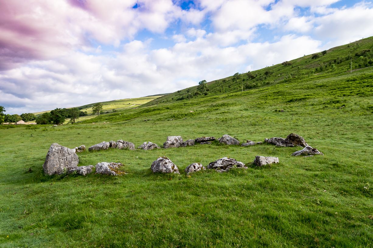
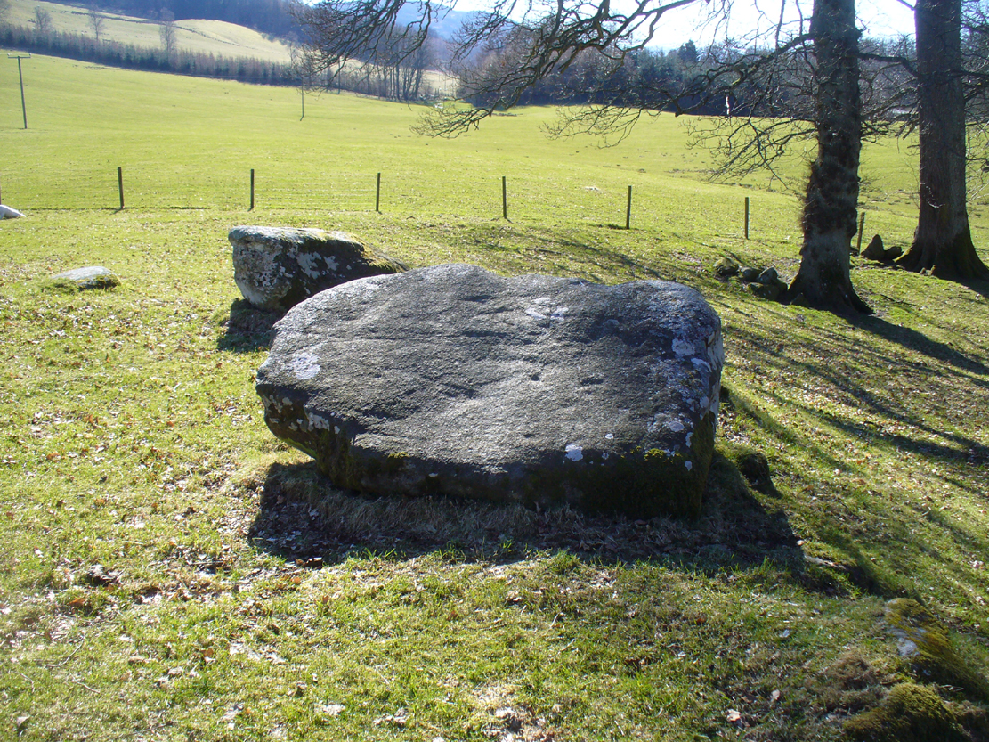
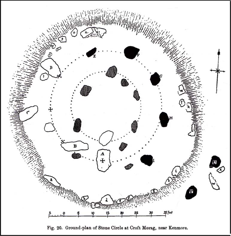
Follow the same directions for the Croft Moraig stone Circle. Then check out the largest of the fallen or elongated stones on the northwest side of the ring, with a smoothed sloping surface, just at the side of the overgrown stone platform on which it rests. Y’ can’t really miss it.
Archaeology & History
When William Gillies (1938) wrote about the carvings at the Croft Moraig stone circle, he told how, previously, Fred Coles,
“noticed that several of the upright stones…show cup-markings on their perpendicular surfaces. Some of these are quite distinct, but others are so worn through weathering that they can only be traced with the fingers.”
Stone D, with faint cupsClose-up of the cupmarks
This is one of them. Barely visible at the best of times, the cup-markings are faded and very hard to see unless daylight conditions are just right. As you can see in the photos, several distinct cup-like impressions are visible, but it only appears that two of them are cup-marks. The others seem to be more geophysical in nature – but I’d love to be wrong!
The great northern Antiquarian Fred Coles (1910) noted that this particular stone (stone D in his ground-plan of the circle) had “been polished by the sliding of generations of children”. This playful action on stones elsewhere in the UK and around the world sometimes relates to fertility rites (i.e., the spirit of the stone could imbue increased fertility upon the practitioner), but Mr Coles made no mention of such rituals here.
Gillies, William A., In Famed Breadalbane, Munro Press: Perth 1938.
Yellowlees, Sonia, Cupmarked Stones in Strathtay, Scotland Magazine: Edinburgh 2004.
Acknowledgements: Many thanks to hardcore crew for our various visits here: to Paul Hornby, Lisa Samson, Fraser Harrick, James Elkington, Penny & Thea Sinclair.