From Mytholmroyd, take the Cragg Vale road (B6138) up and up and up, until you get past the tree-level and the hills open up on either side of you. Take note of the farmhouse on the right-hand side of the road a half-mile on and park where you can. Walk down the track by the farmhouse (known as Washfold Road) and cross the stream at the bottom. OK – from here walk straight up the hill in front of you! (not along the footpath) In less than 100 yards it levels out and you’re onto the moorland proper. From here walk straight west for about 400 yards. If you deviate a little, don’t worry. You’ll see this small upright stone as you’re getting closer, seemingly in line with several other rocks, almost giving the impression you’ve come across a stone row. Good luck!
Archaeology & History
The slim upright
This small squat standing stone is just over three feet tall (1m), about 10 inches thick and 3½-feet across. Leaning at an angle into the ground, this broad but thin monolith has sunk some distance into the moorland peat.
It was located on February 15, 2011, in the company of Dave Hazell (pacemaker in tow!) on our first sojourn of the year. It hasn’t been mentioned in any previous surveys and aint in anyway what you’d call impressive. Nearby are the early remains of old walling north, east and west of here (one of them being a small enclosure of some type), for which I can again find no other references. What looks distinctly like the remains of a large cairn isn’t far away either. However, it may be that some of the remains up here are medieval in nature and it would be of benefit if someone who specializes in remains from that period could have a look here. The equally curious Turley Holes standing stones can be seen a half-mile northeast of here.
To get here, follow the same directions to reach its nearby colleague of Carse Farm south — but instead of walking down the track to where its companion is found, this small ring of stones is found a coupla hundred yards into the first field by the roadside. Unless the field’s fulla corn (in which case, give it a miss cos even if you do find it, you won’t be able to make much out), y’ can’t really miss it!
Archaeology & History
As with its nearby companion of Carse Farm south, this small “ring” of four stones is found along the Tay valley floor and, though cited as a stone circle in many archaeology tomes, should more accurately be defined as a cairn circle of sorts. Structurally akin to other four-posters, it reminded me of a distant companion in North Yorkshire more than 200 miles south: the Druids Altar at Bordley, which is also a robbed prehistoric tomb and not a stone circle. But it’s a fine little site sat amidst the majestic temple of surrounding hills on all sides, bar east, where the Tay valley reaches into the distance.
Faint cup-marksCarse Farm, looking north
Like its damaged companion in the field below, some of the stones in this circle also have well-defined cup-markings on top of the uprights; although when we visited here, low cloud and late daylight conditions prevented us from getting good images of the cup-marks concerned (as the photo of one of them here illustrates). The cup-markings are, curiously, carved on the top of the small standing stones.
Described briefly in Alexander Thom’s Megalithic Rings (1980), he regarded its geometry as “circular” in structure. Aubrey Burl (1988) gave the lengthier archaeological history of the site, telling:
“On the ‘carse’, or lowland…this 4-poster was excavated in 1964. When Coles saw it in 1907 only three smallish stones remained standing although “it seems clear that at this site there were originally four Stones as in so many other Perthshire groups”… The SW stone was missing but halfway between the NW and SE stones a long, thin slab lay half-buried.
“Coles noticed that there were cupmarks on the tops of both the NE and SE stones. The SE had three carvings but the top of the NE had no fewer than 17, the largest ‘cup’ being 4 by 3½in (10 x 9cm). In the group were two ‘dumb-bells’. In the same field the farmer had dragged away a buried stone which was also cupmarked.* (my italics, PB)
“Of the three standing stones, the NE is 3ft 11in (1.2m) high; the SE, 5ft 1in (1.6m); and the NW, 4ft 1in (1.3m). These heights…are almost double those cited by Coles (1908: 126).
“”The 1964 excavation discovered the SW stonehole. The 5ft 10in (1.8m) long stone lying at the centre of the 4-Poster was erected in it, a task made easier by the fact that its base had been keeled… The base was unweathered showing that the stone had been toppled in quite recent times as had the stones of the two Fortingall 4-Posters…3¾ miles to the WSW. The four stones stood at the corners of a rectangle 12ft by 8ft (3.7 x 2.4m) on a long ENE-WSW axis. They also stood on the circumference of a circle 14ft 5in (4.4m) in diameter.
“A tapering pit was discovered against the inner face of the NE stone, about 2ft 6in (76cm) across and 1ft 2in (37cm) deep. It was filled with cremated bone and sticky black earth and charcoal. At the bottom, a collared urn lay on is side, its rim decorated in geometrical designs. A flint flake lay near it. Within the 4-Poster there were three shallow pits, two between the NW and NE stones, another between the SE and SW. Their edges were clean and they had been backfilled with brown loam. The excavators thought they might have “been used for stabilising props during the erection of the stones.” …As the heaviest block, that at the NW, weighed about 6 tons it would have required 20 to 30 people to drag it upright…and the use of such props would have made their insertion safer.”
Unless the people building this site were dwarves, we’ve gotta re-assess this latter remark (which Burl quotes from the earlier archaeologist’s report from the 1960s). Having personally been involved with the creation of modern stone circles with stones larger than the ones here, we know that the uprights here could have been erected by 8-10 people at the very most.
Archaeology and folklore records describe many other prehistoric sites along this section of the upper Tay valley, but it’s also very likely that other “circles” or cairns of similar structure to the two known at Carse Farm once existed close by that are not in modern literary accounts.
References:
Burl, Aubrey, Four Posters: Bronze Age Stone Circles of Western Europe, BAR 195: Oxford 1988.
Pretty easy to find – assuming it aint at the height of summer and the crops are approaching maturity, otherwise you’re only gonna see its head! But, this aside: from Aberfeldy, take the B846 road over the river bridge that bends you along the valley of the River Tay towards Appin of Dull. After some 2 miles you’ll pass the right-turn up to Dull. Go past this for another coupla hundred yards or so, watching out for the left-turn down towards the farmhouse of Carse and park up where you can (if you go past it, there’s the second turn up to Dull, again on your right, where you can turn round). As you walk down the track towards Carse Farm, watch out on your right in the field below Carse I, in the second field down. You can’t really miss it. (and the farmer here is spot on if you ask to check the stone – as long as the crops aint growing)
Archaeology & History
Although all that’s left of what is thought to have been a once proud stone circle is the singular upright standing stone in the middle of the field. Aubrey Burl (1988) thought that this was one of the typical “four poster”rings that scatter our isles, but I’m not so sure misself. There were other stones associated with the site when Burl described it, but these were covered over in our visit here a few months back — which is a pity, as two of the stones are reported as possessing cup-markings (if/when we revisit the site, I’ll try get some images of the respective stones and add them on TNA as individual carved stones). The site gives the distinct impression of it having a funerary character of some sort and not a true stone circle — and this was strongly suggested by some of the finds inside the “ring”, described below.
Fred Cole’s old drawingAubrey Burl’s groundplan
Both this and its associated “circle” a few hundred yards away — known as Carse Farm north — sit on a flat level of ground in the Tay valley, with rounded hills all most sides. This landscape setting was obviously of some importance to the people who put the circle here in the first place but, not living in the region, it’s difficult to assess the mythic relevance some of the hills will have obviously played in the siting of these stones.
In bygone days, it was reported that the much of the site was ploughed away due to agricultural excesses, so there was obviously much more to it in earlier centuries. Describing the solitary stone that’s left today, along with the earlier excavation results, Mr Burl (1988) wrote:
“The stone still standing, of quartziferous schist, is 6ft 3in (1.9m) high. Its longer faces are aligned NW-SE. 32ft 6in (9.9m) to its SW is a large prostate block, sub-elliptical and about 8ft long and 4ft 3in wide (2.4 x 1.3m). It has probably fallen outwards. (my italics, PB) If so, when standing near the top of its inner face were four cupmarks in a cross pattern.
“About 32ft ((9.8m) to its NW is a fallen and enormous schist slab, 11ft long and 5ft wide (3.4 x 1.5m). It also appears to have toppled outwards. Near the bottom of its inner face are two cupmarks. The situation of these three stones suggests that they once stood at the corners of a rectangle some 32ft (9.8m) square, the pillars of a huge four-poster nearly six-times the national average and with an internal area ten times bigger than the small 4-poster (Carse Farm north, PB) just to its north.
“Excavation in 1964 found the socket from which the great prostrate slab had been dragged… Cash (1911) had noted the presence of a small stone inside the ring about 20ft (6.1m) west of the standing stone. It proved to be 4ft (1.2m) square with a carefull-dressed face. It had been set upright, standing about 1ft 4in (41cm) above the ground. Three sides of the worked face ‘had been carefully chiselled away to a straight edge.’ It may have been a slab lining the inner central space of a destroyed ring-cairn. Burnt bone was found near it. There was also a rounded river pebble with a worked hollow on one side…”
Folklore
Carse Farm stone
Stewart (1964) described the site as having been “christianized” not long ago, by having the northernmost standing stone in the ring removed. This is intriguing inasmuch as “north” is the place of greatest symbolic darkness in the pre-christian mythos, and represented death and illumination in magickal terms. North was also the point taken by witches and shamans in their excursions into Underworlds, usually via the North Star, which tethered the Earth to the heavens (see Godwin’s Arktos [1993], and Grant, The Magical Revival [1973]) In the removal of this northern stone for the reasons given, that implies some magickal events or folklore were in evidence here when this took place. Anyone got any further information along these lines, or has it long since been subsumed?
References:
Burl, Aubrey, Four Posters: Bronze Age Stone Circles of Western Europe, BAR 195: Oxford 1988.
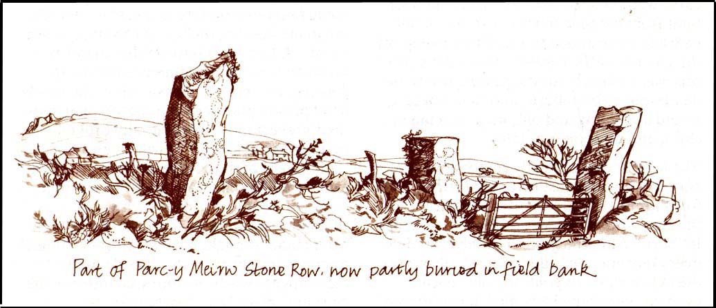
This is an impressive and well-known megalithic stone row, found just 4-5 miles inland from the coastal town of Fishguard. The drawing here is used courtesy of Elizabeth Haines, landscape artist, and gives a fine representation of the site as I’m sure you’d agree! Consisting of at least eight standing stones — four still upright and four laid down — aligning northwest to southeast, the tallest stone stands at the southerly end measuring 11 feet tall. The stone row is found in a region rich in prehistoric remains. Aubrey Burl (1993) said of the place:
“Four of the eight stones in this unusual row still stand, trapped in a field-wall, tow of them now gateposts. Thom suggested that the line, 131ft (40m) long, was laid out downhill towards the WNW and the minor northern moonset just north of Mount Leinster ninety-one miles away across the Irish Sea.”
Quite a distance! And perhaps because of this, Burl thought that the nature of this line of stones was more archaeological than astronomical, with its focal point being more likely up the slope to the ESE instead.
Folklore
There was once an adjacent chambered tomb here which, when it was “destroyed for a house in 1844 brought the owner no luck” (Thom, Thom & Burl 1990) – which is damn good to hear! There was a piece of folklore mentioned by E.L. Barnwell (1868) and other writers that the fields here marked the fall of three Welsh princes in the Battle of Mynydd Carn in 1084. In Roger Worsley’s (1988) fine tour of Pembrokeshire’s historical sites, he tells how these megaliths in the “field of the dead” are also haunted, saying:
“A local tale tells of Ladi Wen, a ghostly White Lady wandering about the fields at night, and who will kill anyone who ventures near; it was enough to keep villagers away from the site well into this century, though the stone row is over five thousand years old.”
References:
Barber, Chris & Williams, John Godfrey, The Ancient Stones of Wales, Blorenge: Abergavenny 1989.
Barnwell, E.L., “Alignments in Wales,” in Archaeologia Cambrensis, volume 14, 1868.
Burl, Aubrey, From Carnac to Callanish, Yale University Press 1993.
Thom, Alexander, Thom, A.S. & Burl, Aubrey, Stone Rows and Standing Stones, BAR 560: Oxford 1990.
Worsley, Roger, The Pembrokeshire Explorer, CCP: Abercastle 1988.
Stone Circle (destroyed): OS Grid Reference – SE 088 256
Archaeology & History
The place-name authority A.H. Smith (1961), in searching for the meaning behind the old region in Halifax known as “stannary”, just west of the town centre, was puzzled by its implications and found it wanting, so he took the most likely option as he saw it, writing, “probably it is a stone circle,” from the archaic verbs stan (stone) and hring (ring).
First recorded in the Halifax Court Rolls of 1575 as “Stannerying”, this implied it to be a place where tin-ware was sold in a field, “though that word belongs rather to Cornwall,” he said, and it appeared out of place at the time it was written. So he looked elsewhere. The Halifax Parish Registers of 1578 didn’t help much, describing the place as “Stanerye.” However, the Halifax Rent Records of 1588 named it as “Standeringe”, which is much closer to Smith’s idea. With each written instance we certainly find the old English stan, but the suffix in two instances is difficult to assess with firm conviction.
If we could locate additional folklore or other historical data that might throw further light on this, it would be an important find. The finding of prehistoric burial remains less than a mile south of Stannary on the other side of town shows that ancient man was in Halifax, but it would be good if we could find more…
References:
Smith, A.H., The Place-Names of the West Riding of Yorkshire, Cambridge University Press 1961-63.
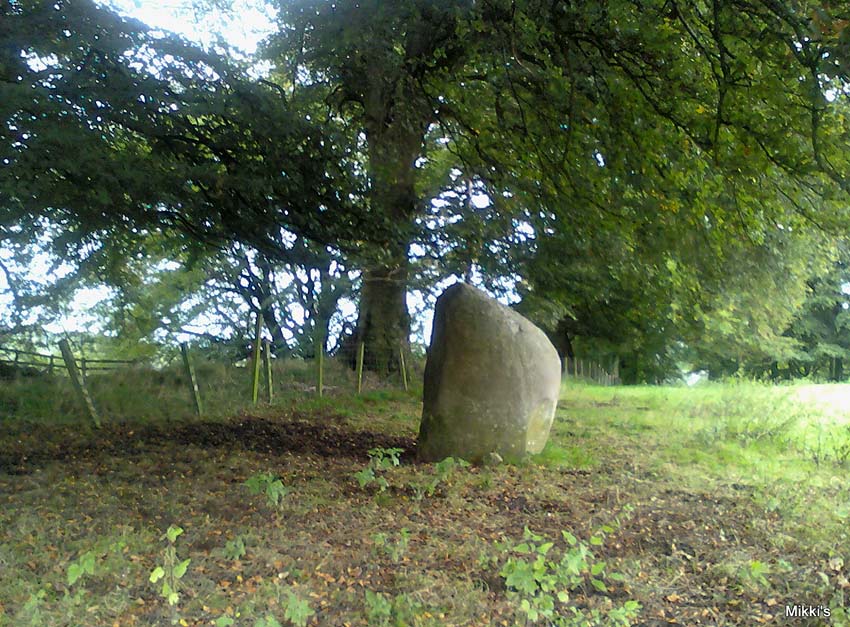
From junction 16 on the A74(M) turn off an go up the B7076 road, roughly parallel with the motorway, for about 2 miles, turning right – over the A74(M) – until you hit the T-junction by the lovely hamlet of Newton. At the T-junction turn right again and along down the road for just 300 yards or so. You’ll see the small Skip Cottage, almost overgrown by the tiny roadside on your right. Stop here and look into the field across the road. It’s right in front of you!
Archaeology & History
Looking SW
Despite the size and almost romantic setting of this large standing stone, I can find little by way of early descriptions or archaeological reports here. Nearly six feet tall with its long axis aligned east-west and in seeming isolation, I find it hard to believe that we have no other sites or relevant data here. Echoing the work by Alexander Thom (1990:2), Aubrey Burl (1993) makes mention of it as one in a possible “pair” of standing stones, with its companion being “18ft (5.5m) away…in roadside bank,” but this is debatable. This second stone seems as much a part of the old walling. On purely subjective grounds, it gave the impression of once playing a part in a stone circle — an opinion also held by the Scottish Royal Commission (1920) lads after their visit here in August, 1912. Does anyone know anything more about this place?
References:
Burl, Aubrey, From Carnac to Callanish, Yale University Press 1993.
Royal Commission on Ancient & Historical Monuments, Scotland, Inventory of Monuments and Constructions in the County of Dumfries, HMSO: Edinburgh 1920.
Thom, A., Thom, A.S. & Burl, Aubrey, Stone Rows and Standing Stones – volume 2, BAR 560: Oxford 1990.
Go through Killin past the Bridge of Lochay pub, turning immediately down the small lane by its side. After about 3 miles you’ll cross over the small river past Duncroisk. Keep going for another few hundred yards (if you reach Tullich you’ve gone too far), watching out for the gate on your left. Walk up to the top of this field, over the wall and up again. You’ll see a couple of tall trees with distinctive walling next to them, just on a ridge above you. That’s where you’re heading!
Archaeology & History
This is a fine-looking example of a prehistoric enclosure, perched on the edge of one of the grassy knolls on the far western extremities of the deserted village of Tirai. If you walk towards it from the derelict village east of here, the elliptical form of the site gives you the distinct impression that you’ve just chanced upon a seemingly unknown stone circle nestled upon the edges of this gorgeous Scottish glen; but this initial excitement is soon dispelled once you get into the heart of the site!
Southern line of wallingLooking east
Although you’ll find a couple of derelict post-medieval buildings on the western side of this structure, the lay-out of this monument would seem to be Iron Age origin, perhaps earlier. It certainly has all the hallmarks of a walled structure from that period and typifies many others that I’ve explored down the years.
The eastern and southern sections of the walls are in very good states of preservation, although the ground has obviously grown up and around the bases of the stonework. It has a total outer circumferences of about 95 yards (87m), with the many upright stones measuring between 12 inches to more than 3 feet in height. The western section of the enclosure is mostly overgrown but easily traced on foot. Near the centre of the site is a large flattish stone that gave the impression of having an oratory function from where one could speak to the rest of the people sat around the inner edges of the enclosure — but this was a purely subjective impression.
NE sections of enclosureOuter section & ‘standing stone’
On the southern side of the elliptical structure is another, outer line of walling, or a stone alignment of some sort just a few yards long, consisting of just a few upright stones — one of which stands considerably taller than all the others hereby, giving the impression of a standing stone. It has a large natural cup-marking on its southern face.
To my limited knowledge there’s been no excavations here, so one wonders whether or how or if the people of Tirai made use of this much earlier building. The Canmore entry of the place tells:
“The N side of this enclosure is a low turf and stone bank of height 0.3m and is 20m long, spread to about 1.2m. The E side is outlined by large stones set on edge with no evidence of intermediate stone walling or turf. A bank of similar more continuous stone extends to the W from the S of the main enclosure down sloping ground. This type of walling is different from any other on Tirai. The large stones set on end have suggested a prehistoric date for this enclosure.”
References:
Johnstone, A. & Wood, S., “Tirai (Killin Parish), Pre-Enclosure Settlements,” in Discovery & Excavation in Scotland, 1990.
From Port Ellen take the A846 road east to Laphroaig, and on the far side of the village, past the small forested part on your left, walk up the slightly sloping hill alongside the small River Kilbride. Over a couple of walls on your way up, look up the small hill to your right (north) and you’ll see these large standing stones.
Archaeology & History
A triple-stone row no less! Although only two of these stones are upright, a third central prostrate stone is included in archaeological surveys as an original upright. And it seems likely. Although passed over in Alexander Thom’s astroarchaeological analyses, Clive Ruggles (1984) looked at this stone row and found the alignment here to possess no solar or lunar function. But if it aligns north the mythic relationship obviously relates to death, as North “is the place of greatest symbolic darkness” where neither sun nor moon ever rise nor set. There may have been an early association with Alpha Draconis, or Thuban in the constellation of the Dragon: the Pole Star in early neolithic times around which the heavens were seen to revolve by our ancestors and hold the pillar of the sky in place. But we may never know. Perhaps by the time these monoliths were erected, the mythos relating to A.Draconis may have faded…
The stones are found amidst a scatter of other neolithic and Bronze Age remains. In the Royal Commission (1984) report on the stones they described the respective monoliths as follows:
“The north stone, measuring 1.28m by 0.35m at the base and 2.70m in height, rises with a gradual taper, the top curving gently to its highest point at the top of the south side. The centre stone, now prone, has fallen onto its E face and lies embedded in the ground with its upper surface (originally the west face) flush with turf; it is 3m long and up to 0.9m broad. The south stone measures 0.80m by 0.40m at the foot and 2.85m in height. It leans towards the west and the top slopes down sharply from the south to a shoulder 2.1m above ground level on the north side.”
…to be continued…
References:
Burl, Aubrey, From Carnac to Callanish, Yale University Press 1993.
Royal Commission on the Ancient & Historical Monuments of Scotland, Argyll – volume 5: Islay, Jura, Colonsay and Oronsay, HMSO: Edinburgh 1984.
Ruggles, C.L.N., Megalithic Astronomy: A New Archaeological and Statistical Study of 300 Western Scottish Sites, BAR: Oxford 1984.
From the village of Midgley, high above the A646 Halifax-to-Todmorden road, travel west along the moorland road until you reach the sharp-ish bend in the road, with steep wooded waterfall to your left and the track up to the disused quarry of Foster Clough. Go up the Foster Clough track for 100 yards and, when you reach the gate in front of you, go over it but follow the line of the straight walling uphill by the stream-side (instead of following the path up the quarries) all the way to the top. Here you’ll see the boundary stone of Churn Milk Joan.
Archaeology & History
The present large standing stone you see before you isn’t prehistoric. However, the small broken piece on the ground by its side may have been its prehistoric predecessor; and there is certainly something of an archaic nature here — albeit a contentious one — as we find old cup-markings cut into its eastern face.
Two ‘cup-marks’ on eastern face
The upright is roughly squared and faces the cardinal points. It was described in Mr Heginbottom’s (1977) unpublished survey on Calderdale rock art, where he described there being a few cup-markings inscribed on its east- and south-facing edges, some of which may be prehistoric — though they would obviously have had to have been carved upon the upright stone when it still lay earth-fast. However, we must posit the the notion (unless some of you have better ideas) that the tradition of etching cup-marks onto rocks was still occurring in this part of Yorkshire until the late Middle Ages, as this stone was, as we know from boundary records, only placed upright to mark the meeting of the three boundaries of Wadsworth, Hebden Royd and Sowerby.
Churn Milk Joan’s other name, Saville’s Low, originates from the great Saville family who owned great tracts of land across the region in the fourteenth century, possibly when the Churn Milk Joan we see today was created. The word “lowe” may derive from the old word meaning, “moot or gathering place,” which this great stone probably served as due to its siting at the junction of the three townships.*
Folklore
In modern times the stone has become a focus for a number of local pagans and New Agers who visit and ‘use’ the site in their respective ways at certain times of the day, albeit estranged (ego-bound) from the original mythic nature of the site.
The name of the stone comes from an old legend about a milk-maid named Joan who, whilst carrying milk across the moors between Luddenden and Pecket Well, got caught in a blizzard and froze to death. When her body was found many days later, the stone we see here today was erected to commemorate the spot where she died. Although such a scenario is quite likely on these hills, as Andy Roberts (1992) said,
“Considering the sheer amount of sites with similar legends this explanation is unlikely to be true and we should looker deeper for the meaning behind Churn Milk Joan, to be found in its positioning in the landscape and ourindividual feelings about it.” [see profiles for the Two Lads and the Lad o’ Crow Hill sites)
The monolith’s other title, Churnmilk Peg, is the name given to an old hag who is said to be the guardian of nut thickets. How this female sprite came to find her abode upon these high hills is somewhat of an enigma, but it was first stated as such in an article by Andy Roberts (1989) in “Northern Earth Mysteries” magazine. E.M. Wright (1913) noted this supernatural creature in her work on folk dialect, describing it as a West Yorkshire elemental who, along with another one known as Melsh Dick:
“are wood-demons supposed to protect soft, unripe nuts from being gathered by naughty children, the former being wont to beguile her leisure by smoking a pipe.”
Another legend of the stone tells how it is said to spin round three times on New Year’s Eve when it hears the sound of the midnight bells at St. Michael’s church (St. Michael was a dragon-slayer) at Mytholmroyd in the valley below. Another piece of folklore tells that coins used to be left in a small hollow at the very top of the stone which, according to Haslem (1981), was “a gift to the spirit world, to bring luck” – a common folk motif. It may equally originate from the custom of it as a plague stone. This tradition of leaving coins atop of the stone is still perpetuated by some local folk.
Mr Haslem also made some interesting remarks about the nature of Churn Milk Joan standing as a boundary stone, representing something which stands not just as a physical boundary, but as a boundary point between this and the Other- or spirit world. In folklore, streams and rivers commonly carry this theme. But here on Midgley Moor, as a standing stone at the junction of three boundaries, we may be looking at the place as an omphalos: a centre point from which the manifold worlds unfold. (see Almscliffe Crags, the Ashlar Chair and the Hitching Stone)
The other motif here, of milk and snow [both white], have been speculated to represent power of the sun at midwinter, and geomantically we find the position of the stone in the landscape exemplifying this: it stands midway in the moorland scenery facing south, the direction of solar power, yet is bounded as an equinox marker from east and west. The winter tales it has nestled around it are merely complementary occult augurs of its more wholesome elements at this point in the hills.
There is however, another much more potent element that has not been conveyed about the site and its folklore—and one which has more authenticity and primary animistic quality. Regardless of ‘Joan’ or ‘Peg’ being the elemental preserved in the landscape title, the ‘churning’ in its name and the ‘spinning’ of the stone in myth at the end of one year and the start of the next at New Year, are folk memories of traditional creation myths that speak of the cyclical seasons endlessly perpetuated year after year after year, in what Mircea Eliade (1954) called the ‘myth of the eternal return.’ As season follows season in the folk myths of our ancestors, everything related to the natural world: a world inhabited (as it still is) by feelings and intuitions learned from an endless daily encounter, outdoors, with the streams, hills, gales, snow and fires. Their entire cosmology, as with aboriginal people the world over, saw the cycles of the year as integral parts of their daily lives. Here, at Churn Milk Joan with its central landscape position along an ancient boundary, the churning and turning of the year was commemorated and mythologized year after year after year; with maybe even the Milky Way being part of the ‘milk’ in its title, from which, in the shamanistic worlds that were integral to earlier society, the gods themselves emerged and came down to Earth.
References:
Bennett, Paul, The Old Stones of Elmet, Capall Bann: Milverton 2001.
Eliade, Mircea, The Myth of the Eternal Return, Bollingen 1954.
Haslem, Michael, “Churn Milk Joan: A Boundary Stone on Midgley Moor,” in Wood and Water, 1:8, 1980.
Heginbottom, J.A., “The Prehistoric Rock Art of Upper Calderdale and the Surrounding Area,” Yorkshire Archaeology Society 1977.
Ogden, J.H., “A Moorland Township: Wadsworth in Ancient Times,” Proceedings of the Halifax Antiquarian Society, 1904.
Robert, Andy, “Our Last Meeting,” in NEM 37, 1989.
Robert, Andy, Ghosts and Legends of Yorkshire, Jarrold: Sheffield 1992.
Wright, Elizabeth Mary, Rustic Speech and Folk-Lore, Oxford University Press 1913.
* The great stone at the cente of the Great Skirtful of Stones, Burley Moor, which previously stood at the centre of the Grubstones Circle, was just such a moot stone. Upon it is carved the words “This is Rumble’s Lawe”.
Follow the same directions to get to the Dumpit Hill A stone circle; but instead when you get to the point where you need to walk off-track and into the heather to get to the circle, keep walking up the dirt-track for about another 200 yards, watching diligently thereby for a reasonable sized, fallen, “standing-stone”-like character just yards into the heather on your right (on your left, there’s a U-shaped dip where the wall is). This is the northern edge of the walled enclosure. From this fallen ‘standing stone’ follow the overgrown walling along carefully into the heather along and down the slight slope. You’re now either on the very edge, or perhaps going into the middle of the enclosure. Look around!
Archaeology & History
East section of walling
There’s no previous written history of this site, discovered for the first time last week on our sojourn to the Dumpit Hill stone circles, by Michala Potts. She didn’t seem too excited by it at the time, but an amble back to what she’d found got me going! (easily done) With the help of the heather being burned away, open and exposed was a distinct line of prehistoric walling — perhaps Bronze Age, perhaps later. It’s hard to tell.
Structurally similar to the enclosure walling at Horse Close and Rough Haw, either side of Skipton, a few miles to the south, here we have about 100 yards of walling seeming to enclose the eastern side of the small hilltop, but running into the heather on its southern edge and the moorland track on its northern side, where it disappears again, leaving no trace of what one would assume would be a consistent western section.
From the grid reference for the site, the line of walling runs northwards for about 20 yards before taking a very slight shift in direction for another 20 yards. Here the walling goes to the left (west) for another 20 yards, before edging slightly northwest and back into the heather. A section of the walling is visible at each end, though we lose any accurate trace of it after a short distance in the long heather. However, at the northwestern point in the enclosure walling, a very distinct long stone about 4 feet high leans at an angle in the ling. It seems apparent that this stone at one point in the not-too-distant past stood upright, making it the tallest stone here.
Northern section of wallingFallen monolith?
What may be other features can be seen inside this enclosure section: a possible hut circle and other portions of walling were noted. However, we didn’t spend much time exploring the site in detail, so there is a high probability of other prehistoric remains in and around this enclosure awaiting discovery. The site’s proximity to the stone circles of Dumpit Hill A and Dumpit Hill B should be noted; along with what the North Yorkshire’s Historic Environment Officer, Robert White, said were “three, possibly four small circular enclosures (about 9m in diameter)” a short distance away. A further survey of the site is necessary to enable us a better picture of what we’re looking at here.