Penny Well, Granton, Edinburgh, Midlothian

Healing Well:  OS Grid Reference – NT 2187 7654

Penny Well on 1853 map

Archaeology & History

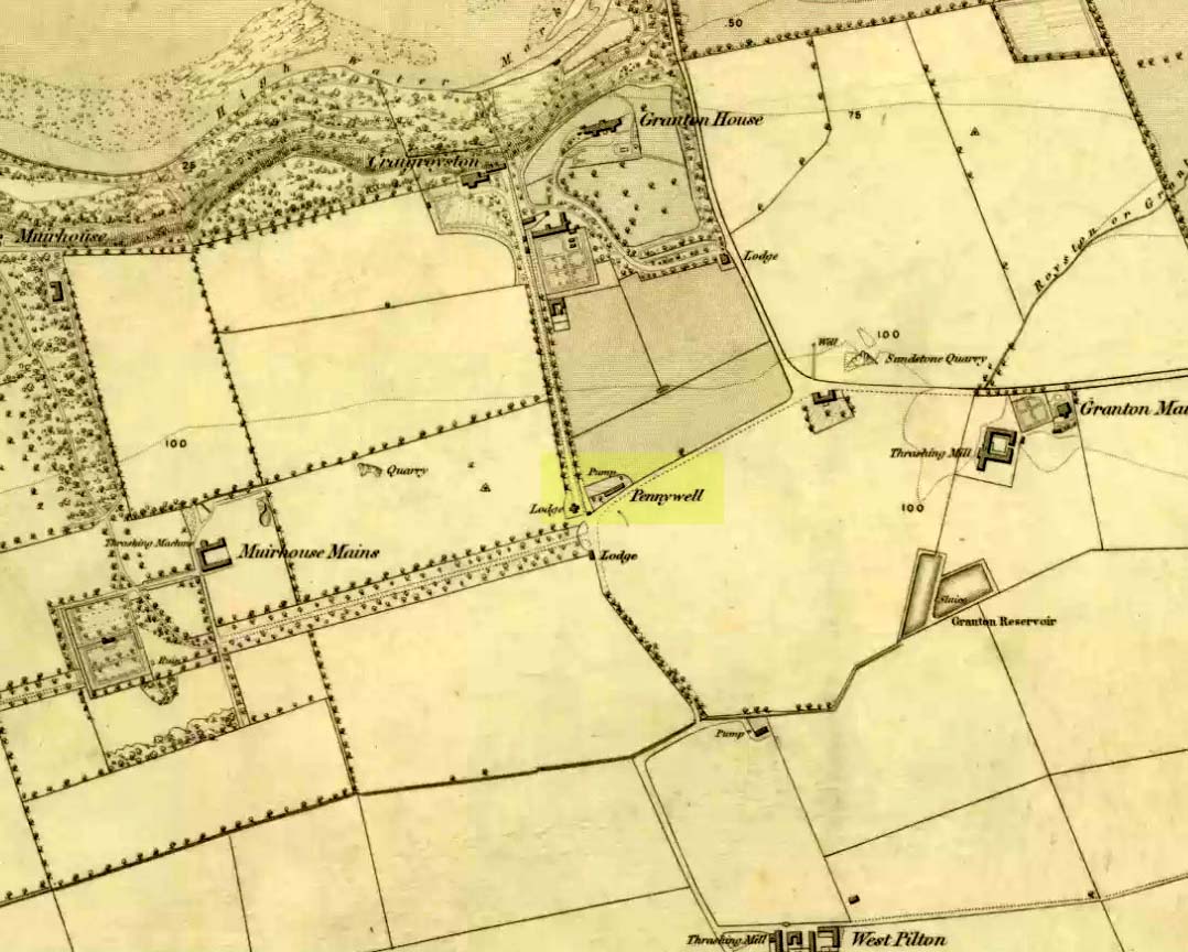
On the 1853 Ordnance Survey map of Granton we are show the house and place-name of Pennywell with a ‘pump’ adjacent to it.  Sadly we don’t have as rich a history of the place as its namesake at Newington.  Its earliest written appearance seems to be in 1812.  A few years later, in the  Ordnance Name Book of the area, it was recorded that,

“Two cottages on the property of Sir John McNeil the name appears to be derived from a well which was formerly situated at the North east end of the houses where one Penny was paid for a draught of water.”

Remembered as a watering place for horses, the old Scots word ‘penny’ may be behind this old name, in terms of it giving the animals and locals their water supply.  Stuart Harris (1996) thought that this Penny Well may have been the long lost St. Columba’s Well in the parish of Cramond.

References:

  1. Bennett, Paul, Ancient and Holy Wells of Edinburgh, TNA 2017.
  2. Harris, Stuart, The Place-Names of Edinburgh: Their Origins and History, Gordon Wright: Edinburgh 1996.

© Paul BennettThe Northern Antiquarian


Spa Well, Davidson’s Mains, Edinburgh, Midlothian

Healing Well:  OS Grid Reference – NT 2049 7524

Also Known as:

  1. Spaw Well
  2. Well of Spaw

Getting Here

Well of Spa on 1853 map

From the west end of Prince Street in Edinburgh central, take the (A90) Queensferry Road.  Go along here for 2.2 miles (3.5km) where the A90 meets the A902. Keep going west along Hillhouse Road for literally 1km (0.62 miles) where you reach a crossroads with the B9085 and there are trees on the right (north) side of the road.  Go into these trees and, before you come out into the fields on the other side, about 150 yards in, walk to your right and zigzag about in the undergrowth.  A small muddy pond is what you’re looking for!

Archaeology & History

Out towards old Lauriston Castle on the northwestern outskirts of the city, these all-but forgotten healing waters became renowned for a short period of time in the latter-half of the 18th century.   They were described in John Law’s Parish of Cramond (1794) where, with some brevity, he told that,

“On the lands of Marchfield is a spring of mineral water called the well of Spaw, reckoned beneficial in scorbutic cases, and highly purgative if drunk copiously.”

It was highlighted in the trees on the earliest OS-map (above) and its ruined remains can still be found.  Stone-lined, the watery remains of this old healing well (undoubtedly a place used by local people before the toffs named it as a ‘spa’) are thankfully still running.  Two other spa wells could be found not far away: one at Lauriston castle, and the other at Barnton.

References:

  1. Bennett, Paul, Ancient and Holy Wells of Edinburgh, TNA: Alva 2017.
  2. Campbell, B.,”Some Notes on the Antiquities and Natural History of Cramond,” in Transactions of the Edinburgh Field Naturalists, volume 5, 1907.
  3. Geddie, John, The Fringes of Edinburgh, W. & R. Chambers: London 1926.
  4. Law, John, The Antient and Modern State of the Parish of Cramond, John Paterson: Edinburgh 1794.

© Paul Bennett, The Northern Antiquarian