Croft Moraig, Kenmore, Perthshire

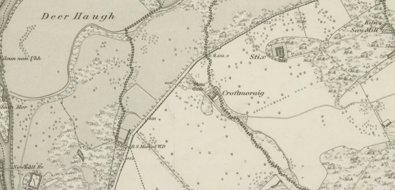
Stone Circle:  OS Grid Reference – NN 79750 47262

Also Known as:

  1. Canmore ID 24891
  2. Croftmoraig
  3. Mary’s Croft
  4. P1/19 (Thom)

Getting Here

Croft Moraig stone circle

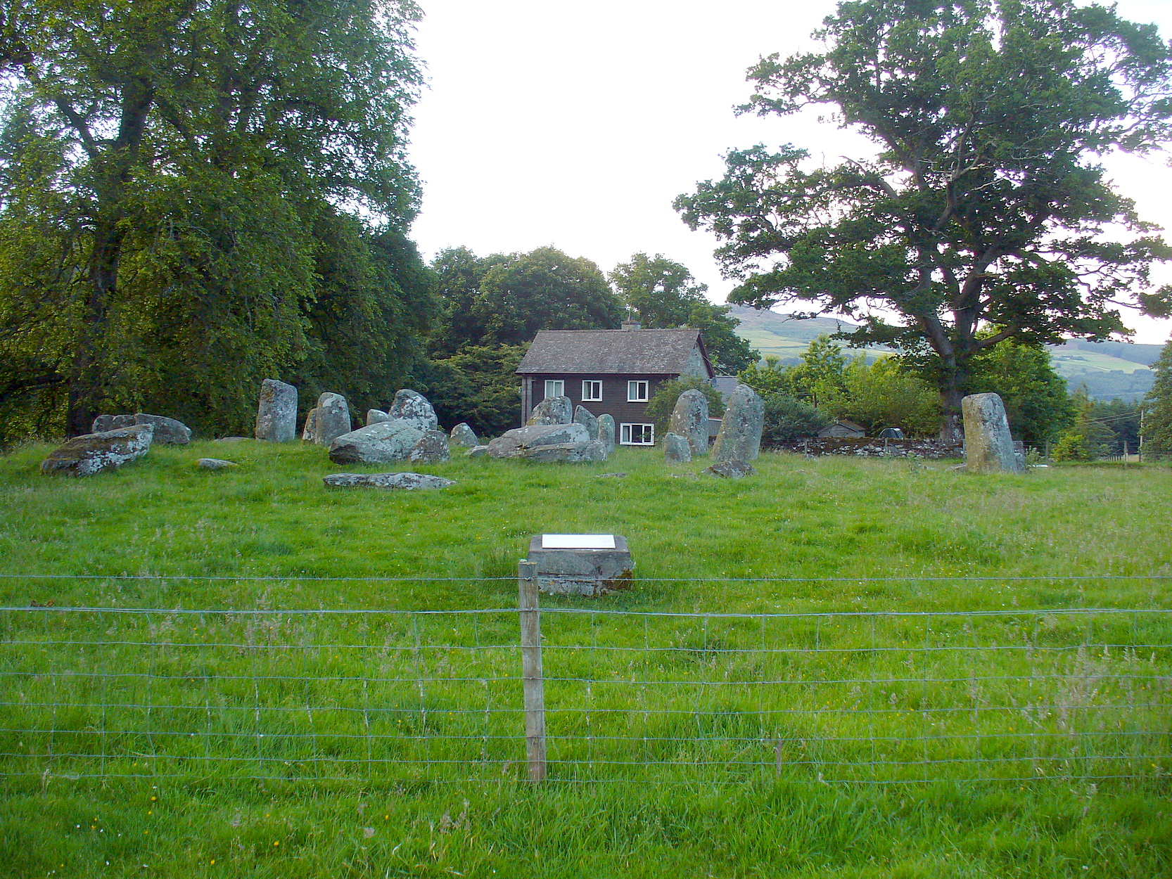
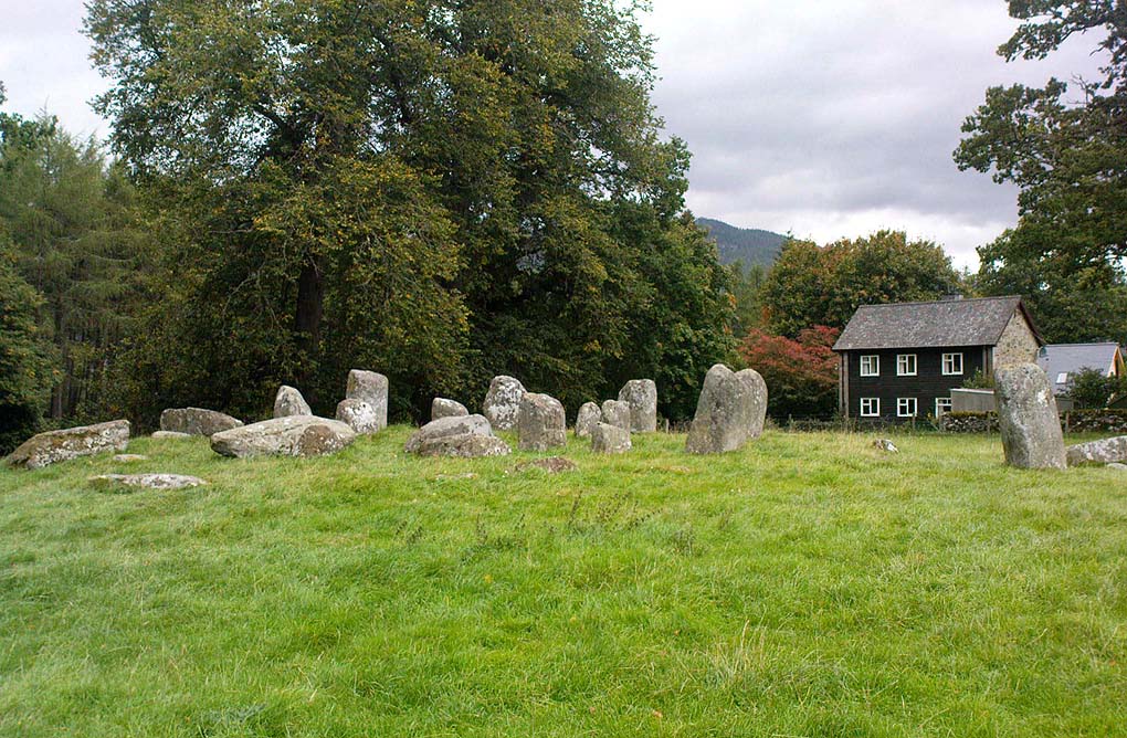
Take the A827 road that runs from Kenmore (top-end of Loch Tay) to Aberfeldy, and about 2 miles outside Kenmore, once you come out of the woodland (past the hidden standing stones of Newhall Bridge) and the fields begin on the east-side of the road, a small dirt-track leads you slightly uphill to the farm and house of Croftmoraig.  The stone circle is right in front of the house less than 100 yards up the track (you can see it from the road).

Archaeology & History

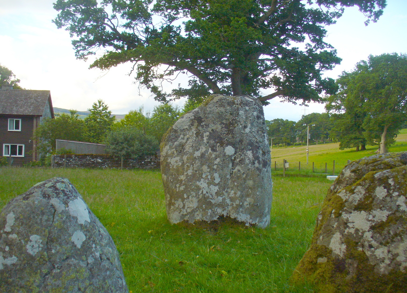
A truly fascinating site, whose history is much richer than its mere appearance suggests.  It has mythic associations with both moon and sun, a cup-marked stone to the southwest, and an earlier structure that had Aubrey Burl (1979) suggesting was possibly “the dwelling-place of a priest, a witch-doctor, a shaman.”  Not bad at all!

Croft Moraig on 1867 map

The sad thing today is its proximity to the increasingly noisy road to Aberfedly whose begoggled drivers care little for the spirit of place or stones.  Here sits a feel of isolation and tranquility broken.  But at least the cold information of its architecture is available for tourists and archaeologists alike; at least their depersonalized appreciations are served!

Described first of all (I think) in the old Statistical Account by Colin MacVean (1796), he told Croft Moraig to be one of “several druidical temples” in the area, “perhaps the largest and most entire of any in Scotland,” he thought:

“It is about 60 yards in circumference, and consists of three concentric circles.  The stones in the outermost (ring) are not so large as those in the inner circles, and are not, like them, set on end.”

Hutcheson’s 1889 plan
Croft Moraig, looking N

The first decent archaeocentric evaluation of Croft Moraig was done in the 19th century by Alexander Hutcheson (1889), who gave us not only the first decent ground-plan of the site, but was also the first person to note that there were some faded cup-and-ring markings at the circle.  After first directing his antiquarian readers to the site, he described the multiple rings of stones here, that had been built on top of an artificial platform of earth and stones:

“The circles are concentric, three in number, and occupy a little plateau which may be artificial, as the outer circle just covers it, on the gentle slope which here rises towards the south from the public road.

“I have prepared and exhibit a plan of the circles, and for reference have distinguished the stones by numbering them in the plan. The inner circle consists of eight stones all standing, with one exception, No. 3, which presumably has fallen inwards. The next or second circle consists of thirteen much larger stones, nine of which stand erect; Nos. 3 and 5 have presumably fallen in, while Nos. 7 and 9 have fallen outwards. The outer circle is formed by a number of smaller stones placed so as to form a sort of rampart. These are recumbent, and lie generally with their larger axes in the direction of the rampart. The circle measures, over the stones, as follows:

“Inner circle, West to East, 25 ft. 6 ins., North to South, 22 ft. 6 ins.
“Second circle, West to East, 40 ft          North to South, 41ft 3in
“Outer circle, West to East,  58 ft          North to South, 58ft

The stones are all rounded or water-worn boulders of dolerite, granite, schist, &c. The stones marked A and B are large blocks, 6 feet 6 inches high, 4 feet broad, and 2 feet 6 inches thick, standing upright. C seems to be a large (section) which has fallen from B, and lies flat on the ground.

“At the south-west side and in the line of the outer circle lies the cupmarked stone… If, as has been suggested, the two large blocks A and B formed the entrance to the circles, then the entrance faced towards the south-east. The blocks vary in height from 3 feet to 7 feet above ground, while of those which I have supposed to have fallen, their dimensions are, naturally from the ground-hold having to be added, much greater, amounting in one of them to 9 feet 6 inches long.  There is a longish low mound of small stones, like an elongated cairn, which might yield something if it were to be searched. It lies just abreast of the cup-marked stone.  I have referred to the recumbent stones in the two inner circles as having probably stood at one time erect. This I have presumed for several reasons, the principal being that one end of each of these stones corresponds in position with the circle formed by the standing stones; and while this is the case the recumbent stones do not preserve a uniformity of direction, but lie indifferently outwards and inwards from the lines of circularity, and at differing angles from these lines…”

Fred Coles’ site plan
One of the cup-marked stones

Some twenty years later, the legendary northern antiquarian Fred Coles (1910) brought his lucidity to Croft Moraig and with it, even greater attention to detail.  In a lengthy description of each and every aspect of the circle that has yet to be equalled he gave the reader the most detailed description we have.  I hope you’ll forgive me adding Mr Coles’ prolonged description, but it is most valuable for anyone wanting to explore the site in greater detail.  He wrote:

“As will be seen from the plan…the structural portion of Croft Morag consists, first, of a roughly circular, earthen mound (lettered in small type a-t), some 3 feet high, which is marked off by several stones of a more or less slab-like character, set irregularly upon a circumference of, approximately, 185 feet. This outermost setting, or revetment of stones is visible now only at certain fragments of the arcs; i.e., it is well-defined on the SW at a, where a long Stone, 6 feet 5 inches by 2 feet lies flat, and bears numerous cup-marks…; on the S arc there are five small Stones (b, c, d, e, f) all earthfast and flattish; on the SE are three similar Stones (g, h, i); on the E arc, four (j, k, l, m); on the N arc, very slightly to the west, one very large Stone (n) flush with the ground at the edge of the bank and a good deal overgrown with grass, measuring 8 feet 6 inches by 3 feet 3 inches; farther to the NW are five stones more (o, p, q, r, s), the last three having only very small portions visible; and, still farther round, is the last of what I consider to be these ridge-slabs (t) close under the edge of the great fallen sloping stone D.  Thus the total number of measurable and separate stones now resting on the outermost ring is twenty.

“The stones of the intermediate ring constitute the imposing feature of the circle. They are thirteen in total number in the present condition of the circle, but they probably numbered eighteen when the circle was complete. Nine of them are the tallest in the whole group; four of these are prostrate on the W arc.  By striking a radius from the common centre of the circle through the centres of these great stones which are erect, to the outermost circumference, the following measures are obtained: from centre of E, the NNW stone, to the ridge 14 feet 6 inches; from F, NNE stone to the ridge 13 feet 4 inches; from G to ridge 14 feet 4 inches; from H to ridge 13 feet 4 inches; and from I, the SE stone, only 10 feet 6 inches.  The four fallen blocks, lying as shown A, B, C, D, no doubt stood on this intermediate ring, the diameter of which measured from centre to centre is 38 feet.  Now, it must be observed that between A and B and A and I there are Stones (shaded in the plan); these two are erect, the one near B measuring 3 feet in length, 2 feet in breadth, and 3 feet 4 inches in height; it is quite vertical, and is undoubtedly in situ. The other small erect Stone midway between A and I has much the same size’ and features. Between B and C there is shown in outline another of these small stones ‘in line’ with the great pillars which remain on the E arc; and it is quite clear that if this remarkable and novel feature of alternating each tall stone with a very small but vertical block was originally carried out all round this intermediate ring, there would have been eighteen stones in all.  Without the most arduous and careful excavation in these interspaces however, it would be extremely difficult, if not impossible, to prove that these small blocks did once stand on the eastern semicircle.

“As illustrating the general size of the great stones, when fully exposed to view, the dimensions of the four fallen blocks are here given: A, 7 feet 7 inches by 4 feet 10 inches, and fully 2 feet thick; B, 9 feet 2 inches by 3 feet 9 inches (on the upper face), and 2 feet 9 inches thick; C, 8 feet by 4 feet, and 3 feet fi inches thick; D, 7 feet by 4 feet 6 inches, and 3 feet thick at its vertical outer edge.

“The five upright stones of the intermediate ring measure as follows: I, the SE stone, 5 feet 6 inches in height, and in girth 11 feet; H, the east stone, 5 feet 8 inches in height, pyramidal in contour, and in girth 11 feet 4 inches; G, the NE stone, 5 feet 3 inches in height and 11 feet in girth; the next stone, F, 5 feet 7½ inches in height and 13 feet 6 inches in girth; and stone E, nearest to the north on the W arc, stands 6 feet 3 inches in height and measures round the base 9 feet 3 inches.

“The stones forming the inner ring, which is a broad oval in form, are eight in number, quite erect, with one exception; the fallen one (shown in outline) is due south of one set at the north point and the distance between these two is 23 feet 8 inches.  If however, the distance between the N Stone and the E one at the SSE be taken, this diameter is 26 feet, as against one of 21 feet taken between the NW and SE stones. Measured from the centre of the fallen stone a space of 10 feet 3 inches divides that from the centre of the erect stone on the east, and an equal space divides it from the centre of the stone on the west. Between the N stone and that on its southwest an equal space of 11 feet 3 inches exists as between that stone and its SE stone; but between these last two there is a third almost exactly midway.  The fallen stone measures 5 feet 10 inches by 3 feet 9 inches; the NW stone is 4 feet 6 inches in height, the SW stone 3 feet 6 inches, the N stone 3 feet 4 inches, the NE one 2 feet 6 inches, and the stone between it and the fallen block 3 feet 4 inches in height.

“In addition to the feature above noticed, of tall stones alternating with much smaller ones, Croft Morag possesses another noticeable arrangement in the presence of two great massive monoliths (U and V on the plan) standing like the remains of a portal, nearly eight feet outside of the boundary ridge on the SE.  Neither of these stones is now absolutely vertical, stone U leaning considerably out towards the SE, and V having a very slight lean inwards to the circle. The former is 6 feet 2 inches in vertical height with a basal girth of nearly 12 feet, which is probably an under-estimate, for there are two large fragments (w and x) which appear to have been severed from this stone, the edges of which nearest the fragments are rough and sharp.  The latter (V) stands 6 feet 4 inches in height and girths 11 feet 8 inches…

“…Besides its complexity of arrangement and the great number of measurable stones, forty-two in all, this circle is emphasised by the existence of a cup-marked stone set in a portion of its structure…on the SW arc… There are nineteen cups in all, only two of which differ much in diameter and depth from the rest, and there does not appear to be anything in their design to suggest a meaning or lend a clue to their symbolism.”

When the monument was excavated by Stuart Piggott and his mates in 1965, it was found to have been built over many centuries.  As Aubrey Burl told:

“The first phase, of the late neolithic, consisted of about 14 heavy posts arranged in a horseshoe shape about 25ft 10in x 22ft 10in (7.9 x 7m) with a natural boulder at its centre.  Burnt bone was found near this.  Outside was a surrounding ditch and at the E was an entrance composed of 2 short rows of posts.

“In the second phase the timbers were replaced by 8 stones graded in height towards the SSW, also erected in a horseshoe 29ft 10 x 21ft (9.1 x 6.4m).  A rubble bank was heaped up around it.  On it at the SSW was a prostate stone with over 20 cupmarks carved on it.  Other cupmarks were ground into the NE stone.

“Finally a circle of 12 stones, about 40ft (12.2m) is diameter, was erected around the megalithic horseshoe with a pair of stones forming an entrance at the ESE.  Graves may have been dug at their bases later.”

Fred Coles mentioned a couple of other local names given to the site, one of which – Mary’s Croft – he thought may point “to a dedication to the Virgin.”  Another curious place-name next to the site is called Styx,

“which appears to be the modern abbreviated form of the Gaelic word stuicnean.  This, Mr Dugald McEwan affirms, meant ground full of overturned forest-trees; and it is therefore probable that in the remote past all the land surrounding the Stone Circle was a deep forest, and perhaps because of its seclusion, this site was selected as the most fitting for the erection of the principal Circle of the district.”

Alex Thom’s ground-plan

When the engineer and archaeoastronomer Alexander Thom (1967) came to examine Croft Moraig, he found the outlying stones to the southeast could have been solar alignment indicators, albeit poor ones.  However, the geometric structure of the ring appeared to further confirm the use of his Megalithic Yard by those who built the circle.  Thom’s illustration shows his finding, which he described briefly as follows:

“Two concentric circle and an ellipse.  The circle diameters drawn are obviously too large and could be as small as 58.5ft outer circle and 41.0ft inner.  Outer circle diameter58.5ft = 21.5 MY.  Perimeter 67.5 MY = 27 MR.  Inner circle diameter 41.0ft = 15.1 MY.  Perimeter 47.3 MY = 18.9 MR.  Ellipse drawn has major axis 11 MY, minor axis 8 MY, distance between foci is 7.5 MY.  Perimeter is 30.0 MY = 12 MR.  This ellipse looks slightly large but the triangle on which it is based and the perimeter are almost perfect.”

Folklore

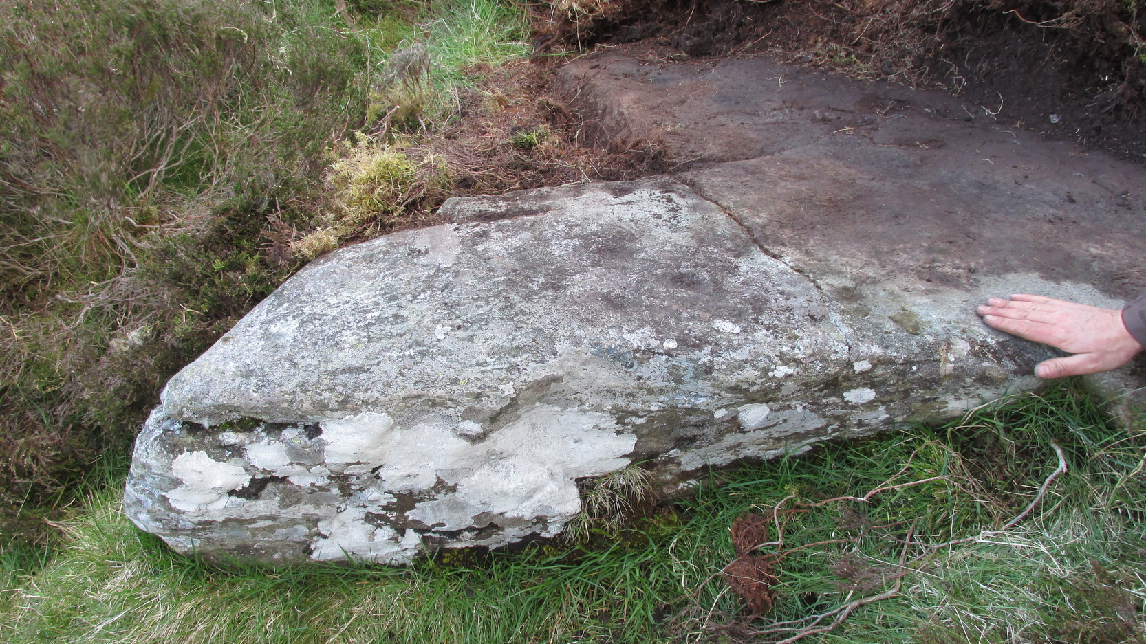
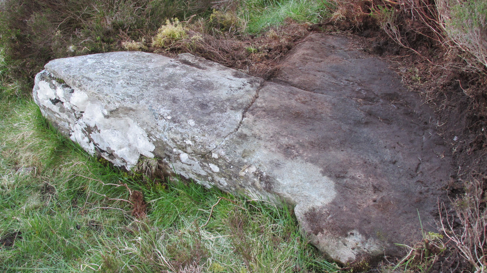
Old lore told that the standing stones of Newhall Bridge 850 yards away (777m) were once connected with the Croft Moraig circle.  William Gillies (1938) told this tradition saying,

“that at one time there was a paved way connecting the circle, of which these stones are the remains, with the great Croftmoraig circle.”

Croft Moraig, looking W

Fred Coles also noted that one of the stones in the circle (stone D in his plan) had “been polished by the sliding of generations of children”. This playful action on stones elsewhere in the UK and around the world sometimes relates to fertility rites (i.e., the spirit of the stone could imbue increased fertility upon the practitioner), but Coles made no mention of such rituals here.

References:

  1. Burl, Aubrey, Rings of Stone, Frances Lincoln: London 1979.
  2. Burl, Aubrey, The Stone Circles of Britain, Ireland and Brittany, Yale University Press 2000.
  3. Coles, Fred, “Report on Stone Circles Surveyed in Perthshire,” in Proceedings of the Society of Antiquaries, Scotland, volume 44, 1910.
  4. Gillies, William A., In Famed Breadalbane, Munro Press: Perth 1938.
  5. Hutcheson, Alexander, “Notes on the Stone Circle near Kenmore,” in Proceedings of the Society of Antiquaries, Scotland, volume 23, 1889.
  6. MacVean, Colin, “Parish of Kenmore,” in The Statistical Account of Scotland – volume 17, William Creech: Edinburgh 1796.
  7. Stewart, M.E.C., “The excavation of a setting of standing stones at Lundin Farm near Aberfeldy, Perthshire“, in Proceedings of the Society of Antiquaries, Scotland, volume 98, 1966.
  8. Thom, Alexander, Megalithic Sites in Britain, Oxford University Press 1967.
  9. Thom, A., Thom, A.S. & Burl, H.A.W., Megalithic Rings, BAR: Oxford 1980.

© Paul Bennett, The Northern Antiquarian


Lochmaloney, Kilmany, Fife

Cup-and-Ring Stone (destroyed):  OS Grid Reference – NO 379 204

Archaeology & History

J.R. Allen’s 1882 sketch

Here’s another old carving that has succumbed to the lack of animistic respect endemic in modern culture.  Ronald Morris (1981) reported that this carved rounded boulder was “dynamited by the farmer and (is) now no longer extant.”  First described in 1882 and later included in the Fife Inventory (1935), the large smooth rock used to lay within a nice copse of dense gorse, measuring 2½m x 1¾m across and about 1m high from ground level.

It was uncovered in 1872 and mentioned briefly for the first time in Arthur Mitchell’s (1874) fine essay on the antiquities of Cromar, where he told that “Dr. Batty Tuke tells me there is a cup stone on a moor forming part of Lochmalonie farm, in the parish of Logie, Fifeshire.”  His notes were followed up by the great Romilly Allen (1882), whose sketch is all that remains of this ancient site.  The carving was subsequently included in one of Ron Morris’s (1981) survey of Scottish petroglyphs, describing it simply as,

“2 cups-and-one-complete ring (one mostly weathered off), diameters 10cm (4in) and 27 cups (carving depth and angle of slope not now known.”

Its isolation from any other known petroglyphs is a little odd and there is every possibility is accompanied a prehistoric burial of some sort; although from the attitude of the farmer, all trace of that would have gone too.  On a more positive note, when Batty Tuke spoke with Romilly Allen about this carving, he told that he has “frequently noticed well-marked cups on dry stone dykes in the Glenduckie area.”  Petroglyph explorers amongst you might want to spend some time meandering in this neck o’ the woods….

References:

  1. Allen, J. Romilly, “Notes on some Undescribed Stones with Cup Markings in Scotland,” in Proceedings of the Society of Antiquaries Scotland, volume 16, 1882.
  2. Mitchell, Arthur, “Vacation Notes in Cromar, Burghead and Strathspey,” in Proceedings of the Society of Antiquaries Scotland, volume 10, 1874.
  3. Morris, Ronald W.B., “Fife: Loch Maloney – Cup Marks,” in Discovery & Excavation, Scotland, 1967.
  4. Morris, Ronald W.B., The Prehistoric Rock Art of Southern Scotland, BAR: Oxford 1981.
  5. Royal Commission on Ancient & Historical Monuments, Scotland, Eleventh Report with Inventory of Monuments and Constructions in the Counties of Fife, Kinross and Clackmannan, HMSO: Edinburgh 1935.

© Paul Bennett, The Northern Antiquarian


Dun Toiseach, Ford, Kilmartin, Argyll

Dun:  OS Grid Reference – NM 8808 0476

Getting Here

The hill of Dun Toiseach

You can see the rocky hillock ‘pon which this old dun sits from the roadside – and can approach it by either climbing up the slope, or go round t’ back and approach it from t’ track. Either way, it’s easy to get to.

Archaeology & History

This old dun was rather ramshackled when I used to sit here, sometimes on my way home from working at the Inverliever Nursery, a bit further up the lochside — but it was a good spot to sit and daydream into Loch Awe and beyond…

Described as a vitrified fort, the structure is oval in shape.  Thought to have been constructed in the Iron Age, Dun Toiseach was originally about 50 feet across and its walls averaged 10 feet thick, with an entrance at its northeastern side.  The Royal Commission lads (1988) described it thus:

Dun Toiseach plan (after RCAHMS 1988)

“Situated on a prominent rocky knoll overlooking the S end of Loch Awe 250m ESE of Torran farmsteading, there is a severely ruined dun measuring about 16m by 13m within a wall which has been some 4m thick. Two stretches of outer facing-stones are visible, as well as a few possible stones of the inner face, but, particularly on the NE, the wall has been severely robbed and the core material scattered. The entrance lies on the NE, the innermost portion of the SE passage-wall and what may be a door-jamb on the opposite side still being visible.  The knoll has acted as a focus for recent field-walls, but there is no indication that it was additionally defended by outworks. A small modern cairn…surmounts the dun wall on the SE.”

References:

  1. Royal Commission on the Ancient & Historical Monuments of Scotland, Argyll – Volume 6: Mid-Argyll and Cowal, HMSO: Edinburgh 1988.

© Paul Bennett, The Northern Antiquarian


Loch Derculich, Dull, Perthshire

Sacred Loch:  OS Grid Reference – NN 864 549

Folklore

Although this upland loch is today renowned as little more than a decent fishing spot, the waters here were long known to be haunted and the abode of a legendary water spirit.  In local tradition, the loch is said to be named after “an ancient Chief of Pictish origin” — whose burial mound is nearby — and in James Kennedy’s (1928) fascinating folklore work he also told that,

“Loch Dereculich was the habitation of a ‘Tarbh Uisge’ (water bull), the dangerous water demon… This dreaded monster, as the Norwegian peasant will gravely assure a traveller, demands every year a human victim, and carries off children who stray too near its abode… Less than one hundred and twenty years ago, the Loch Derculich Water Bull was seen sauntering along its shores.  At peat-making times it was observed very frequently.”

References:

  1. Kennedy, James, Folklore and Reminiscences of Strathtay and Grandtully, Munro Press: Perth 1928.

© Paul Bennett, The Northern Antiquarian


Clach na Sithean, Strathtay, Perthshire

Cup-Marked Stone:  OS Grid Reference – NN 895 531

Also Known as:

  1. Balendune
  2. Ballinduin

Folklore

This large cup-marked stone was known by local people as the Clach na Sithean, or the stone of the fairies.  Its smooth surface and well-cut grooves was said to be due to the fairies sharpening their knives upon it, and the straight cuts or grooves were tests of the keenness of their blades.

In addition to the fairies having hold over this stone, a brownie creature also roamed between here and the burn of Allt Mor.  Although a dutiful creature, he commonly used to scare the women when they returned from the ceilidhs by chasing them and screaming a curious noise at them. But as well as this, he would also enter the local houses and farms after nightfall and, when the local folk were asleep, would clean the supper dishes and put them in their rightful places. But if there was no work to be done once he had entered their homes, he would take the dishes out and place them on the floors where they would be found in the morning by perplexed householders.  Then they’d know that the brownie had visited. Sometimes he was a great help to the housewives, other times a nuisance.  He became known to local people as Puddlefoot, or Cas an Lubain, but so offended was he by the name when he heard it, that he let out an almighty scream and vanished, never to be seen again.

References:

  1. Kennedy, James, Folklore and Reminiscences of Strathtay and Grandtully, Munro Press: Perth 1927.

© Paul Bennett, The Northern Antiquarian


Dun Dubh, Ford, Argyll

Dun:  OS Grid Reference – NM 8640 0479

Getting Here

From Ford village, take the track that goes uphill (west) running near the edge of the forest-line. Keep going until you hit the top of the forest and the large rocky hill above you (on your right) is where you need to be heading.  The rise to your left is Dun Chonallaich.  Walk around the bottom of the hill until you get to the other side (you should be 100 yards or more above the tree-line) where you’ll notice a ‘pass’ running west, with a rocky knoll above you on your right.  That’s it!

Archaeology & History

Thought to date from the Iron Age, the remains here cover an area 15 yards by about 25 yards.  Remains of walling around the edge of the summit nearly a yard wide in places define quite clearly where the ‘fort’ was centred.  The entrance to the site was found on the northwestern side.  In more recent times however, animal pens have intruded on the remains here and the archaeological remnants are much denuded.

Folklore

Samhain fires were lit on the larger ridge above this ruined fort until recent years, as some old local folk will tell you. These Halloween fires (done to celebrate the old New Year) were stopped a short time after the new ‘owner’ of the Auchinellan Estate (on whose land Dun Dubh is found) took exception to them and, for all intent and purpose, deemed them a fire hazard! The lady in question who inherited the Estate was in fact a devout christian who took exception to the local “pagan” goings-on, contrary to the beliefs of the previous Estate owner, who not only allowed such old events, but played a part in them.  Local folk hereabouts, not surprisingly, aint too keen on their part-time dictatorial christian neighbour.

The fires up here were also related to the linear cemetery at Kilmartin. Here the giant tombs all line up & point to Dun Chonallaich, behind which hides the more flattened top of Dun Dubh. When the Halloween fires were lit on top of this, the glow from behind the great pyramid of Chonallaich all the way down the Valley of the Kings, was spectacular!  One wonders just how long the local people had been doing this.  Quite a long time I imagine….

References:

  1. Royal Commission on the Ancient & Historical Monuments, Scotland, Argyll – volume 6, HMSO: Edinburgh 1988.

© Paul Bennett, The Northern Antiquarian


Loch Seil, Kilninver, Argyll

Crannog (submerged):  OS Grid Reference – NM 80390 20292

Also Known as:

  1. Canmore ID 22994

Getting Here

A beautiful place found along the roadside towards Seil Island, on the B844 a few miles south of Oban.  When you get near the south end of the loch right by the road, have a gander!  If the waters are low you can sometimes see the ghostly island appear above the waves…

Archaeology & History

You’re lucky to see anything here – as the crannog has all but submerged.  This old artificial island could once be clearly seen less than 400 yards south of Duachy farmhouse, near the southwestern edge of the loch.  It measured roughly 10 yards by 8 yards, was built of stones, seemingly “with a boat-slip on the west side and a ‘square place’ on the east as if for a landing stage.”  All trace of the causeway linking it to the shore has apparently vanished.  But if you do stop here, check out the Duachy Standing Stones on the hillside behind you!

References:

  1. Royal Commission on the Ancient & Historical Monuments of Scotland, Argyll – volume 2: Lorn, HMSO: Edinburgh 1974.#

© Paul Bennett, The Northern Antiquarian


King’s Park, Stirling, Stirlingshire

Cup-and-Ring Stone:  OS Grid Reference – NS 7837 9299

Also known as:

  1. CEN 12 (R.W.B. Morris survey, 1981)

Getting Here

King's Park cup-and-ring, Stirling
King’s Park cup-and-ring, Stirling

Not too hard to find really.  On the far western edge of the King’s Park golf course, head for the highest point where the small cliffs drop down.  From here, walk down the footpath on the slight slope south, just below where the small copse of trees are, and you’ll see the singular small flat stone in the grasses near the footpath you’re walking along.  If you can’t find it – look around!

Archaeology & History

A little-known but fascinating isolated carving, first described by David Morris at the sixth meeting of the Stirling Natural History and Archaeological Society in 1901.  It is found on the western edge of the town, above the rocky edges not far from the pond of St. Thomas’ Well on the far edge of the golf course.  Morris’ finding was written up in their fine journal, where he wrote:

“In the King’s Park, about 50 yards east of the cliff where a seat overlooks the Douglas Terrace sand quarry, there is a smooth surface of rock showing through the turf, measuring two-and-half feet by one-and-half feet… On it is a cup-shaped hollow, outside the rim of which is a well-marked hollowed ring, beyond which is another faintly marked, concentric circular groove.  The cup-mark measures one-and-a-half inches across; the inner rim of the first circle is 4 inches, and the outer rim is 6 inches in diameter.  The outer circle, if complete, would be 9 inches in diameter.  The depth of the central hollow is half-an-inch, and of the inner groove fully one-quarter of an inch.  The markings are plainly artificial…”

King's Park CR - central design, with finger pointing to northernmost cup!
King’s Park CR – central design, pointing to northernmost cup

In good sunlight, it is obvious that the carving is a fine example of a double-ringed cup-and-ring carving – though the outer ring may not be complete.  The Scottish Royal Commission lads told that “this rock outcrop bears three cup marks” – one of which has the rings surrounding it.  In the first photo here, the southernmost cup-marking is highlighted in the centre of the two shells which were on the rock when we arrived.

However, there’s definitely more to this carving than previous investigations have outlined.  It seems that the northernmost cup-mark has a ring and a possible outer-ring.  There is also a distinctive linear carving, which at first seems like a primitive triangle, just below the southernmost cup – as we’ve tried illustrating here in the photo which Mikki Potts took.  It’s faint, but once you see it, it’s obvious that it’s there.  Other faint lines of similar nature also seem apparent near the northernmost cup-marking, but we will have to wait for rubbings and further visits in better light to ascertain the full image on this rock.  Well worth checking out if you like your rock art! (can any of you Scottish rock-art fanatics have a closer look at this? – take a rubbing of it and see what other aspects are on this design)

Faint linear carvings on southern end of the rock

One other thing which seemed apparent when we were here: this site has all the geomantic hallmarks of accompanying a burial at some time in the ancient past.  Its isolation here is unusual and the carving is only 50 yards from the highest point hereabouts, where you have 360-degree views all round, typifying the position of many prehistoric tombs.*  Does anyone know about such features, or have records of any field-name surveys taken, which might confirm or deny this thought?  Twouldst be good to know!

References:

  1. Feachem, Richard, Prehistoric Scotland, Batsford: London 1963.
  2. Morris, David B., “Cup and Ring Marked Rock Surface in King’s Park,” in Stirling Natural History & Archaeology Society Transactions, 1900-1901.
  3. Morris, Ronald W.B., The Prehistoric Rock Art of Southern Scotland, BAR 86, Oxford 1981.
  4. Royal Commission on the Ancient and Historical Monuments of Scotland, Stirlingshire – 2 volumes, HMSO: Edinburgh 1963.
  5. Royal Commission on the Ancient & Historical Monuments of Scotland, Archaeological Sites and Monuments of Stirling District, Central Region, Society of Antiquaries of Scotland 1979.

* Since writing the above, thanks the correspondence of Paddybhoy, we’ve learned that there definitely were prehistoric tombs close by; one being just at the bottom of the ridge below the carving, on Douglas Terrace.  Records describe several other prehistoric tombs nearby at Birkhill House, the Birkhill Sandpit and Coneypark Nursery.  However, I still think it most probable that there were other tombs and more rock art, probably along the edges of King Park, aswell as the Cambusbarron plain.  These need locating.

© Paul Bennett, The Northern Antiquarian


Ford, Kilmartin, Argyll

Tumulus:  OS Grid Reference – NM 86899 03572

Getting Here

Ford Tumulus on 1875 map

Although I describe this site in association with the township of Kilmartin, it is in fact several miles north of there – but I reckoned that if I say it’s near Kilmartin, then those of you who don’t really know this region, will have some idea of its locale.  So – from Lochgilphead, go up north thru Kilmartin, another coupla miles on, till you reach the small road to your right (signposted ‘Ford’).  Just keep driving for a couple more miles until you hit the village.  If you park by the only shop, you’re just past the old tomb.  Diagonally across on the opposite side of the road from the Ford Hotel, right by the road-junction, just before the little shop, you’ll see a notable rounded mound overgrown in shrubs. Embedded in this are the remains of an old tomb.

Archaeology & History

Ford tumulus (photo, couresty J. Reid)

This typical-looking fairy-mound just by the road junction in the village is where me and my daughter used to scramble around, sometimes playing and sometimes seeing if we could find anything of note in this ancient hillock, but all trace of any prehistoric stonework seems to be well-buried.  When excavators explored the site in bygone times, a small stone cist was found, which aligned (yet again) north-south and measured internally, roughly, 3ft x 2ft.  Only small!

A food vessel in Edinburgh’s central museum, “found in a cist in the neighbourhood of the lower end of Loch Awe” is thought to have come from this tomb.

References:

  1. Royal Commission on the Ancient & Historical Monuments of Scotland, Argyll – volume 6: Mid-Argyll and Cowal, HMSO 1988.

© Paul Bennett, The Northern Antiquarian


Drumderg (3), Tullymurdoch, Perthshire

Cup-Maked Stone:  OS Grid Reference – NO 18488 55054

Getting Here

Drumderg (3) petroglyph

Go up the A93 road from Blairgowrie, after 5 miles turn right at the Bridge of Cally and up Glen Shee.  After another 3½ miles, keep your eyes peeled for the iny road on the right signposted to the Drumturk Cheese farmshop.  Go up this long tiny winding road, a mile up past the cheese place (which are gorgeous btw!) and onto the open moors.  Keep on this road for another 2¼ miles where you can park up near the entrance to the huge wind-farm.  Walk up the track to the windmills, bearing right at the first junction, then right again at the next one.  From here, walk to the second windmill and from its base walk down, east, into the heather for about 80 yards. You’re damn close!

Archaeology & History

Drumderg (3) carving

On this T-square-shaped earthfast stone, a hundred-and-twenty yards north of the impressive Drumberg (2) petroglyph and just 10 yards below the remains of an impressive hut circle, we find this somewhat plain cup-marked design.  It was covered pretty deeply beneath the heather when we came here and it took some time before we could see what we were looking at.  The grey skies and poor daylight didn’t help matters either, as the cups were difficult to make out at first, but, thankfully, you can just about see them in the photos.

There are between five and seven shallow but distinct cup-markings on the flat surface, one of which may have a faint ring around it.  In truth, this carving’s only gonna be for the real geeks amongst you.

© Paul BennettThe Northern Antiquarian