Follow the same directions to get to the cup-marked stone on the slope behind Duncroisk Farm. Once here, look up the hillside and about 100 yards above you there’s the fence, and a gate in the fence. Go through that gate and walk uphill for some 20 yards where you’ll meet with a large sheet of flat sloping rock with a stream by its side. The crosses are on this rock sheet at the top left-hand side.
Archaeology & History
Although the stone here is pretty easy to find, the insignia carved on the rock itself can be troublesome to see. The accounts by both Cormack (1952) and Morris (1981) each recommend visiting the site around sunrise, but an hour before sunset is also profitable if you wanna see the design with any clarity. And of course, if you keep the rock-face wet (the adjacent stream is handy here) the carvings stand out even better!
Main section of carvingSolar cross & arrow?
It’s a quite superb carving in a truly superb setting, come rain, shine or mist — but for the cup-and-ring aficionado’s amongst you this one might not get y’ going, as we’re looking at a carving that was probably born of the more recent mythic period. Although there are between two and four faded cup-markings here, the principal designs do not echo the more usual neolithic and Bronze Age carvings scattering this part of Perthshire. Instead we find very worn examples of what have been variously called “solar wheels”, “Greek crosses”, Celtic crosses, etc. We also find simple carved ‘arrows’ at the ends of both natural and man-made lines in the rock; along with very distinct ‘eye’ or vulva symbolism. (Crawford 1957) Added to this is the possibility of human figurines discernible in the carving, very similar indeed to those found in Spain (Kuhn 1956) and elsewhere.
The site was first described by E.A. Cormack (1952) who wrote the following, (slightly edited) piece:
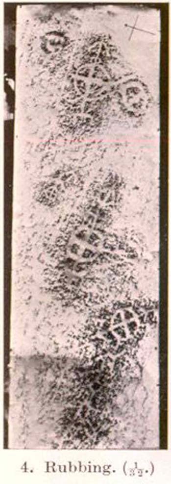
“Examination of the rough and sloping rock surface revealed an interesting group of inscribed figures, confined to an area of about 8 by 2½ feet, four of which included a cross within a circle. The figures are difficult to discern, except when thrown into relief by early morning sunlight, but are clearly demonstrated on a rubbing.
Cormack’s 1952 rubbing of the carving
“The crosses may be described in three groups:
“Group 1 — a) Near the upper edge of the rock is a cross within a circle of 8-inch diameter. The vertical axis of the cross is extended below the circle for 4 inches, resting on an ill-defined rectangular base, and upwards for 5 inches to form an arrow-head with 3-inch barbs. At the junction of the shaft of the arrow with the top of the circle is a pair of contiguous rings of about 1-inch diameter. The cross is deeply cut, to about a half-inch depth, with equal arms 4 inches long and 1 inch broad. The left arm of the cross extends beyond the circle, but this may be due to the circle being slightly excentric in relation to the cross. The lower right quadrant of the circle is marred by a natural crevice in the rock, but careful examination shows that the circle does not cut the right arm of the cross.
b) On each side of this figure is a roughly circular marking, one about 4 inches above and to the left, of 3-inch diameter, and the other 2 inches to the right, of about 5-inch diameter. In each there is an indefinite depression across the centre.
“Group 2 — a) About a foot below and to the right of Group 1 there is a boldly cut cross within a 7-inch circle. Again the vertical arm of the cross is extended above and below the circle, downwards for 5 inches to a curved arrow-head with 4-inch barbs, and upwards as an equal armed 5-inch crosslet above which is a 4-inch circle with the central axis continued through it. (The junction of this axis through the circle with the top of the small cross is slightly angled.) The main cross and circle are cut to fully half an inch in depth and one inch in breadth, but the upper part of the figure is much less distinct.
b) About 8 inches to the left of the upper part of the above figure is a very faintly incised cross within a 2½-inch circle. It is difficult to discern on the rock, but can be seen in the photograph and is very clear on the rubbing. It also appears to have an arrow-head above it.
“Group 3 — a) A foot below and to the right of Group 2 is a clearly cut cross within a 6½-inch circle. A natural cleft in the rock has been used for one axis of the cross, which lies obliquely to the others already described, and this axis terminates in an arrow-head 3 inches below the circle, and another slightly smaller arrow-head is cut 2 inches above the circle; in each case the angle formed by the arrow being towards the circle.
b) Immediately below the last cross is a curious hieroglyph not easy to make out on the rubbing, but clear in the photograph. On an 18-inch vertical axis can be seen from above downwards an arrow-head, an oblique line to the left, a faint 2-inch circle, a transverse stroke, and finally two oblique lines to the right. A natural crevice to the left of the figure rather confuses the picture.”
Ron Morris’ (1981) description wasn’t as detailed and he was initially hesitant about using the site in his rock art survey of the area, as he thought it “most likely to be early christian” in nature and period. He changed his view after talking with an associate at Bergen University, who pointed out that the symbols found here up Glen Lochay were “exactly the same as Norway’s second commonest symbol, the ‘Cross-ring’, which is contemporary with their cup-and-ring series.” Morris described the carvings here as:
“3 ‘cross-rings’ and 7 other rings, some of which have traces of crosses within them. There are also grooves, some extending from a ‘cross’-line to form an ‘arrowhead’, and one group, with ring above, rather resembles a ‘man.’ Largest ring diameter, 20cm (8in) and greatest carving depth, 1cm (½in).”
Examples of the artistic symbolism found at this ‘Duncroisk Crosses Stone’ are scattered throughout western Europe from the Bronze Age period onwards: notably at Dowth and Clonfinloch in Ireland (Brennan 1983; Coffey 1912); Jonathan’s Cave, Fife (Simpson 1867); Valcamonica, Italy (Anati 1961); and all over Norway and Sweden (Coles 2005; Gelling & Davidson 1969; Janson 1966). In more recent times we find these curious symbols etched inside the prehistoric chamber of Ty Illtud (Grinsell 1981) — but these are thought to be later additions. However, the universal nature given to such interconnecting symbols such as those found here is, simply, ritual magick. We find it across the Himalayas, Africa, north and south America – just about everywhere. It would be quite wrong to believe that the presence of an encircled ‘cross’ on this stone relates it to a christian belief system, as such a motif is found in many non- and pre-christian societies with a mythic nature akin to that of the swastika, i.e., of a world unfolding or emerging from a centre-point and the arms of the ‘cross’ outwards defining the directions and boundaries of any specified cosmology: be it landscape, heavens, spirit worlds, pregnant belly, etc.
Solar cross? Eye? Vulva?…or dancing human figure?
As Cormack (1952) described, the respective groups of carvings are integrally linked by an interconnecting line that joins the symbols in the respective groups to the other symbols. The fact that the connecting ‘lines’ are natural is meaningful in the relationship between humans and Nature; but moreover, the connecting line linking the symbols strongly implies sequential reasoning and magickal import. Indeed, these three distinct clusters (see Cormack’s rubbing) are functionally akin to magickal sigils, examples of which are found across the ancient and modern world. This is a notion that must be given serious consideration as a function in the carved stone of ‘Duncroisk 4’. Equally we can see in one section of the carving what may be a dancing human figurine, very much like rock carvings found elsewhere in Europe and beyond.
Both Erich Neumann (1973) and Alex Marshack (1972), for slightly different reasons, would also see the images carved here as early expressions of human development: either through i) the emergence of archetypal patterns and the interpretative interplay of the ego, or ii) the intellectual evolution of magickal appliance, whereby imagery and human action are recognized as meaningful in a wider natural sense. In the case of Duncroisk 4 it would more likely possess magickal import, as symbols were much more than ‘art’ and possessed meaning on several interconnecting levels, one of which being ritual function — an element that modern archaeology is slowly learning to incorporate into its analyses.
Dancing Siberian ShamanDancing shaman figure?
A more in-depth comparative essay is really needed to give a clearer exposition defining the nature of this carving… My personal view is that the carving represents, not some solar design, but one of Britain’s earliest artistic examples of human beings, in this case dancing and beating a drum or bodhran. It may indeed be the earliest pictorial example of a bodhran in the country. I’d say so. There is also the distinct possibility that the dancing figure is a shaman. We have many petroglyphs from all over the world that highlight such a character, integral to all early cultures—and this is as likely a contender as any for such a figure. (see Gough 1999; Whitley 2000, etc) It may however, be a warrior with a shield. You see the problems we can have with these damn carvings! 🙂
Folklore
This carved rock is said by local people to have been where a ‘Celtic’ saint delivered sermons to the heathen populace. The saint concerned is likely to be the one who tradition tells gave his name to the small glen immediately across the track from here: St. Charmaig. Halfway up the small glen is a small cave, barely accessible, with untouched remains of dried roots and other elements of human habitation therein. A few hundred yards to the north in old Finn’s Glen, is the forgotten Waterfall of the Oracle which sometimes isn’t even there!
References:
Anati, Emmanuel, Camonica Valley, Alfred Knopf: New York 1961.
Brennan, Martin, The Stars and the Stones: Ancient Art and Astronomy in Ireland, Thames & Hudson: London 1983.
Coffey, George, New Grange and other Incised Tumuli in Ireland, Dolphin: Poole 1977.
Coles, John, Shadows of a Northern Past: Rock Carvings of Bohuslan and Ostfold, Oxbow: Oxford 2005.
Grinsell, Leslie V., “The Later History of Ty Illtud,” in Archaeologia Cambrensis, 131, 1981.
Janson, Sverker & Westman, David, Rock-Carvings at Fiskeby, Esselte AB: Stockholm 1966.
Kuhn, Herbert, The Rock Pictures of Europe, Sidgwick & Jackson: London 1956.
Marshack, Alexander, The Roots of Civilization: The Cognitive Beginnings of Man’s First Art, Symbol and Notation, Weidenfeld & Nicolson: London 1972.
Morris, Ronald W.B., The Prehistoric Rock Art of Southern Scotland, BAR 86: Oxford 1981.Neumann, Erich, The Origins and History of Consciousness, Bollingen Princeton University Press: New York 1973.
Royal Commission on the Ancient & Historical Monuments of Scotland, Archaeological Sites and Monuments of Stirling District, Central Region, Society of Antiquaries of Scotland 1979.
Simpson, James, Archaic Sculpturings of Cups, Circles, etc., Upon Stones and Rocks in Scotland, England and other Countries, Edmonston & Douglas: Edinburgh 1867.
Whitley, D.S., The Art of the Shaman: Rock Art of California, University of Utah Press 2000.
The stone marking the position of the well is situated on the north side of the road at the east end of Grange Loan, a few yards west of the junction with Findhorn Place, at Newington on the south side of Edinburgh. Unfortunately, all that now remains of the well is a red sandstone front with two pieces of metal on each side.
Archaeology & History
Set back a little into the wall alongside the road, we today see only the architectural memory of this once famous and much-reputed holy well, whose waters sadly no longer flow. Curiously omitted from the primary Scottish surveys on holy wells, it was long known as an important water source by the people of Edinburgh in ages past. The best article on the site was written by W.F. Gray (1962) some fifty years ago, in which he told:
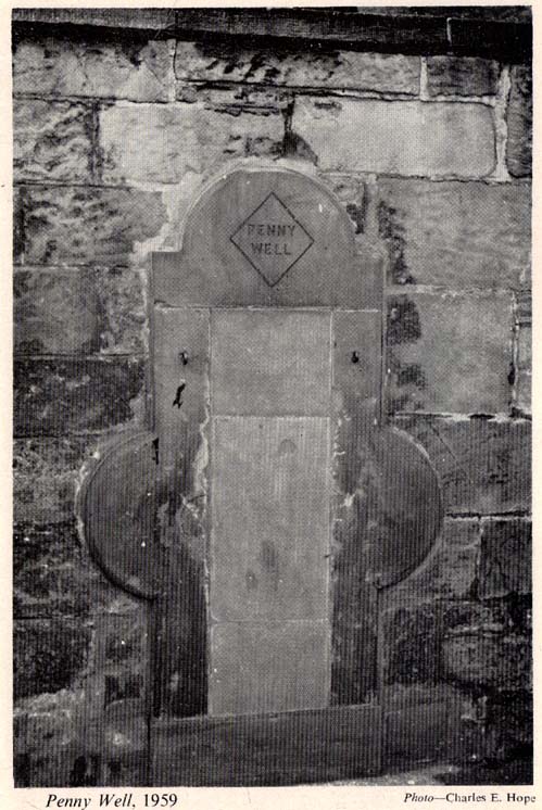
“Built against a garden wall, the Penny Well looks rather forlorn. Now that a plentiful supply of water is in every dwelling, its public usefulness is definitely at an end, though it may slake the thirst of a passer-by. But however that may be, the Penny Well has a long if not distinguished history, though fact and fiction, it is to be feared, are inextricably linked.
“And first, as to its age. There is documentary evidence of the existence of the Penny Well as far back as 1716. In that year Sir William Johnston of Westerhall, Dumfriesshire, disposed to William Dick of Grange three acres of his lands of Sciennes, which are described as bounded on the west by the lands belonging to “said William Dick and the Penny Well.” The well really marked the south-east boundary of the lands of Grange.
“The actual age of the Penny Well is unknown. All that can be positively stated is that it has existed for at least two hundred years… How the Penny Well came by its name is another unsolved mystery. There is a story to the effect that in the earlier half of the nineteenth century an old woman who lived in the cottage opposite the well had charge of the spring and sold the water to wayfarers at a penny a glass. A very plausible story by which to account for the name! Unfortunately its credibility is shaken by the fact that…the spring was known as the Penny Well fully a century before…
“Sir Thomas Dick Lauder, when he took up residence at Grange House in 1832, was deeply interested in the well at the east end of his property. He had it restored and above it placed a tablet with the words, ‘Penny Well’ inscribed on it.
“About 1870, when feuing operations were in progress and there was much digging in the vicinity of the well, the water suddenly ceased to flow. After an interval, however, it again became copious, so much so that it formed a tiny pond in front of an adjoining house. In the hope of drawing off the water, a pit was dug. This led to an interesting discovery. Five feet below the surface, workmen came upon what there seems no reason for doubting was the original trough of the Penny Well. This “interesting and unexpected find” (to quote from The Scotsman) was covered by a large block of hard sandstone. The trough, which was circular, measured 32 inches across and had a depth of fully 1o inches in the centre.
“The Society of Antiquaries made investigations and the opinion was hazarded that “the basin into which the water ran was without doubt a baptismal font,” possibly the one which once stood beside St. Roque’s Chapel, situated at the southwest end of Grange Loan, but long since removed.
“In the (1890s) the Penny Well underwent a second restoration, the Town Council providing £30 for the purpose. By this time however, the spring was found to be impure, but the trouble was got over by substituting the town water.”
Folklore
Penny Well in 1959
Although there are no documents proving with certainty, local tradition reputed this to be one of Edinburgh’s numerous holy wells. It probably was. And whilst W. Forbes Gray seemed at a loss to explain the name of this old water source, it probably comes from the old practice of local people dropping pennies and other offerings into the well in the hope that the spirit of the waters would confer good health or other benefits upon the hopeful pilgrim. Such rites, of course, are very ancient indeed and relate specifically to the animistic spirit-nature of the site. In Mr Gray ‘s (1962) essay on the Penny Well he also had this to say:
“According to one statement, it was a holy well attached to the Convent of St. Catherine of Sienna (which stood at the foot of St. Catherine’s Place), a well whose waters were possessed of miraculous powers of healing those afflicted with blindness, in which case it would be in the same category as the well of St. Triduana at Restalrig, and the Balm Well at Liberton.”
Reputed in times gone by to be one of the never-failing springs, this clear and sparkling water supply would keep bubbling away long after all others in the area had dried-up during summer droughts.
“It is also said that the ubiquitous Mary Queen of Scots, when she visited the religious sisterhood at Sciennes, partook of the waters of the Penny Well. “
The folklorist John Nicholson (1890) wrote about this “block of natural concrete standing at the head of Drewton Dale, near South Cave” — which modern OS-maps call Austin Dale. Legend told how it “derived its name from St. Augustine, who used to preach from this stone to the heathen, before Britain became christian.” This obviously supplanted an earlier heathen site, but it’s difficult to work out what that may have been. It could have been the lost ‘Rud Stone’ immediately west; or perhaps had some traditional relationship with the healing well which emerges a short distance away further down the valley. Just above here as well, we find an ancient dragon’s lair at Drakes Hole, which could also hold a clue to this place.
A couple of years after Nicholson mentioned the site, John Hall (1892) published his excellent history of the township, in which he described St. Austin’s Stone thus:
“It’s a mass of rock projecting from the side of a hill and in its longest part, extending from the hillside to the face of the stone, measures about 60 feet. By some it is supposed to have formed a centre for druidical worship, and that the adjoining township took its name of Drewton (or Druid’s Town) from this fact. When St. Augustine came to England…he is said to have visited this part of the East Riding; and that this stone took its name from his visit.”
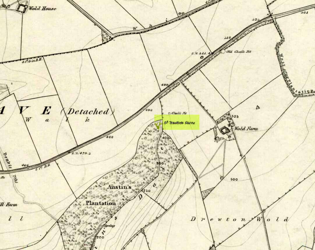
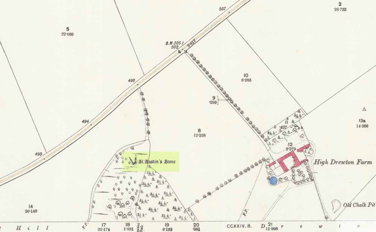
St Austins Stone 1890 map
The site was also surmounted by a cross at some time in its recent history, but this has gone. The earth mystery writer Philip Heselton (1986) told that the nearby Well was indeed a place connected to St. Austin’s Stone, in an early article in Northern Earth Mysteries, saying:
“St. Austins Stone near South Cave is a rock outcrop where Saint Augustine is said to have made converts, baptizing them in a nearby well. The site is used for church services. Every seven years, part of the stone falls away, but it always grows again.”
The site should be examined for potential cup-and-ring markings; as well as reports on the status of the Well. Any photos of the present situation of the site would be most welcome.
References:
Gutch, Mrs E., County Folk-Lore volume VI: Examples of Printed Folk-loreConcerning the East Riding of Yorkshire, David Nutt: London 1912.
Hall, John George, A History of South Cave and other Parishes in the East Riding of Yorkshire, Edwin Ombler: Hull 1892.
Nicholson, John, Folk Lore of East Yorkshire, Simpkin Marshall: London 1890.
Thompson, Thomas, Researches into the History of Welton and its Neighbourhood, privately printed: Kingston-upon-Hull 1869.
The well is all dried up today, but its remains are about 200 yards north of the river Wharfe. Sam Brewster (1980) told the easiest way to find it: “To get there from Thorp Arch you take the trackway that goes to the south of the church and follow this until you are walking alongside the river; eventually you will come to a barrier of barbed wire near some old disused water-works; get under or over this barrier and turn 90 degrees to your left, following the barbed wire until you come to a wood, the other side of the barbed wire; go into the wood and turn right; keep exploring near the edge of the wood until you find a tree under which is a hollow which used to be St. Helen’s Well.” Once here you can see where the water used to flow down a narrow channel and under a little bridge.
Archaeology & History
Carved cross remains found near St Helen’s Well
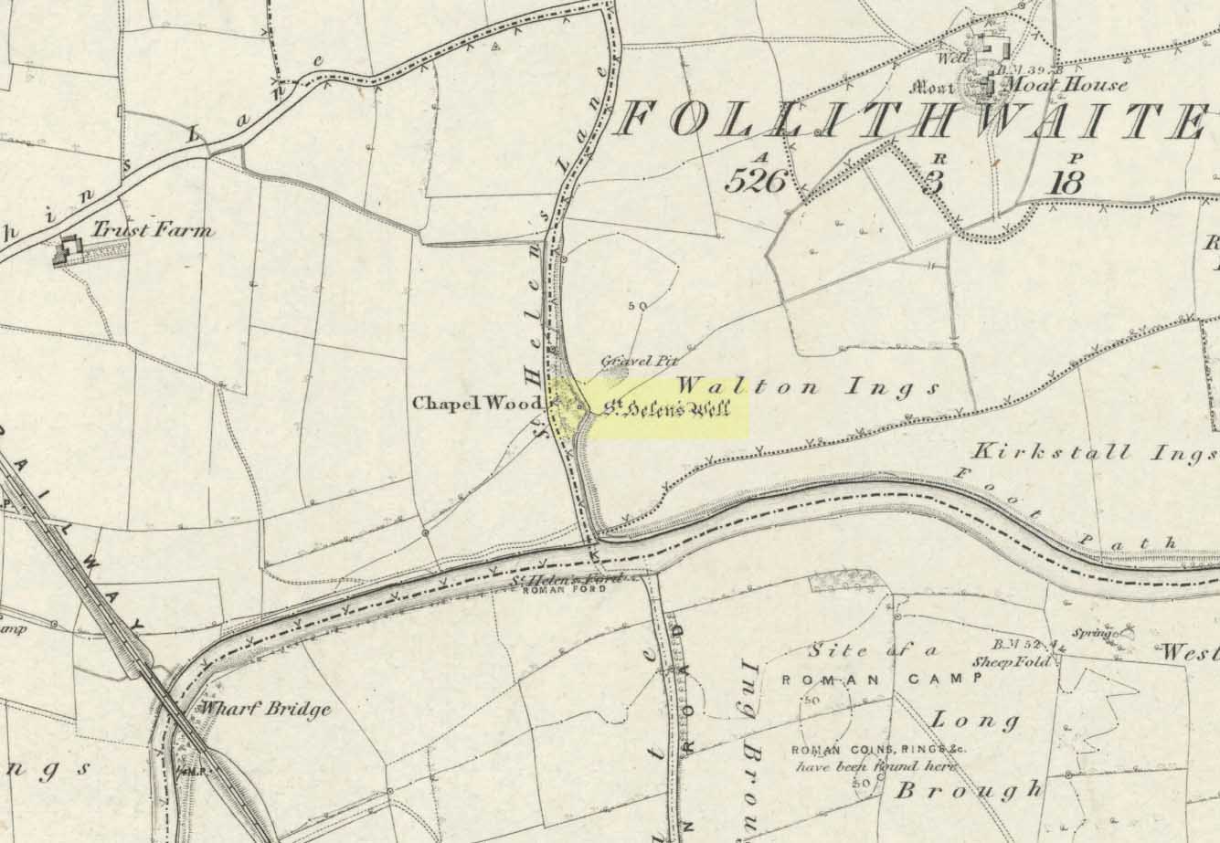
This ancient and well-known healing spring is shown on early OS-maps emerging a short distance north of the River Wharfe besides St. Helen’s Beck in Chapel Wood, adjacent to the Kirkstall Ing or field. In the western fields close by was once an ancient chapel and, closer to the holy well, once “stood St. Helen’s (or St. Helena’s) Cross, which is somewhat crudely represented in Dr. Whitaker’s History of Craven“, (Speight 1902), illustrated here.
This well possesses a prodigious occult history yet is curiously absent from most studies on the subject. The place is said to have been a respected holy site that was venerated long before the Romans arrived here. Found at a place called the Rudgate — but known locally as St. Helen’s Ford — it is also said to be haunted. Angela Smith (n.d.) considers the traditions surrounding the well to be pre-Roman, and the curative waters would certainly have been known of at the time of their occupation here,
“because it lies at the side of Roman road No.280, just north of where it crosses the River Wharfe at St. Helen’s Ford, leading to the Roman fort at Newton Kyme.”
St Helens Well in 1900
Several species of psychoactive plants grow adjacent to the well, which are thought by Phillips, (1976) Devereux (1992) and I as serving ritual shamanic purposes. The likelihood is more so than not. The oracular nature of the site which R.C. Hope (1893) and others have described here is particularly interesting: in traditions the world over, oracles were often consulted after the ingestion or use of sacred plants, such as are found here.
Due to the sacred nature of this spring and its importance in local folklore and history, it should be recovered from its present state. The fact that this place was highly important as a ritual and sacred site to christians, pagans, Romans and peasants alike, and now hides all-but-lost and forgotten is a disgrace.
Folklore
A fascinating tale hangs over this still-revered holy well which legend tells had a chapel standing adjacent, dedicated to Helen in the 7th century – although no trace of it is visible today. Local historian Edmund Bogg (1904) recounted how a local sexton told of “padfoots and barguests and ‘that grim foul beast with clanking chain’ which on dark nights kept its vigil” near St.Helen’s Well. Padfoots and barguests are Yorkshire names for spectral black dogs, said to be bringers of death and misfortune (they are one of several remaining folk-ingredients from the Underworld myths in British shamanism).
St Helen’s Well, c.1935St Helens Well in 1934
Folklorist Guy Ragland Phillips (1976), referring to an article in The Dalesman in 1971, told how a Mrs Dorothy Tate as a young girl used to visit the site and would tie pieces of rag on the bushes aside the place as grateful offerings to the spirit of the well. She said however, that she had gone about doing this in the wrong way, as according to tradition such offerings are to be done secretly. The article showed a photograph of Mrs Tate (from 1908) tying one of the memaws to the wych-elm tree overhanging the old spring.
People visited the well – probably on August 18 – to divine the future with the oracle which Hope (1893) described as being here, always in the dead of night without being seen, leaving before sunrise. It has been visited by thousands of people over the centuries, with gifts of rag-hangings, pins and other memaws. Such offerings continue even to this day. When Harry Speight (1902) visited St. Helen’s Well at the turn of the century, he related how as many as forty or fifty hangings would be left at any one time on the branches of the trees. He wrote:
“The water is beautifully soft and clear, and in former times was much resorted to as a specific for sore or weak eyes. There are two other springs close by, which were also held to be sacred, but they do not bear any particular dedications. An old plantation a little north of the well is known as Chapel Wood, which commemorates St. Helen’s chapel and the ancient church at Bilton, three miles further north, and about a mile to the east of the Roman Rudgate, is also dedicated to St. Helen.”
A few years before Speight’s visit here, Dr Fred Lees and the botanist, Robert Baines, visited St. Helen’s Well, and wrote similarly of the lore and memaws they found there:
“There are veritably hundreds of these bedizenings affixed and removed surreptitiously (probably before sunrise), according to an unwritten law, for none are ever caught in the act. And yet during the summer months a careful observer may detect almost weekly evidence of a shy communicant with the ghostly genius of someone¾country maid or her dumb shy swain. What murmured litany (if any) had to be said is lost; most likely nothing more was necessary than the unspoken wish…Pieced together and codified, fact and heresay testify as follows: ‘The visitor to the grove, before rise of sun, has to face the tree [a wych-elm overhanging the well] to detach from his or her own person some garment, to dip it in the well, and having knotted or whilst hanging the fragment to any convenient twig…is to breathe a ‘wish’ telling no-one what that wish may be; these conditions strictly observed, what is desired shall come to pass.'” (in Phillips, 1976)
When the archaeologist C.N. Bromehead (1935) and geologist J.V. Stephens came to the site in the 1930s, despite the fall of the well, he was surprised to find local peasants still respecting the spirits of the site, reporting:
“There is now no well or visible spring, but from the position at the lower margin of a gravel terrace it is obvious that water would be obtained by digging a few feet; a small stream flows just east of the site… It is curious that the hanging of rags should survive when the actual well has vanished, but the writer has visited the spot many times in the last seven years and there are always plenty of obviously recent additions. The custom is to stand facing the well (i.e., due west), preferably after sunset, wish, and then attach something torn from one’s clothing either to the big tree — wych elm — or to any of the bushes. Probably the custom is largely maintained by vagrants who frequently camp in the wood, but it also has its attraction for courting couples from the neighbouring villages!”
Such offerings at the site of St. Helen’s Well are still left by locals and some of the plastic pagans, who tie pieces of artificial material to the remnants of the wych-elm and other trees, which actually pollutes the Earth and kills the spirit here. Whilst the intent may be good, please, if you’re gonna leave offerings here, make sure that the rags you leave are totally biodegradable. The magical effectiveness of your intent is almost worthless if the material left is toxic to the environment and will certainly have a wholly negative effect on the spirit of the placehere. Please consider this to ensure the sacred nature of the site.
…to be continued…
References:
Bogg, Edmund, Lower Wharfeland, the Old City of York and the Ainsty, James Miles: Leeds 1904.
Brewster, Sam, ‘St. Helen’s Well,’ in Wind & Water 1:4, 1980.
Bromehead, C.N., ‘Rag Wells,’ in Antiquity IX, March 1935.
From the Chester ring road head into north Wales along the coast road (A548) from Connah’s Quay for about 13 miles taking you through Flint. After 12 miles turn left into Holywell town (Treffynnon). At the western end of the town go down the Greenfield-Mostyn road back towards the A584 taking you down a hill. After 500 hundred yards you arrive at the holy well/shrine and pilgrimage centre on the right-hand side; there is parking on the opposite side of the road. There is a small entrance fee, but as well as the famous healing well and bathing pool, they have a gift shop, toilet facilities and a late medieval/Gothic two-storey structure that is built over the polygonal, vaulted well chamber, whilst at the side (at the corner of the hill) stands another Gothic chapel from 1500.
History and Legend
According to the well known legend, a young Welsh girl called Winefride or Gwenfrewi, was the daughter of patrician parents, Thenith (Thewyth) and Gwenlo, who lived at Bryn-y-Castell (Treffynnon) at the beginning of the 7th century AD. She was a very religious girl who was known for her kindness and charities to people in the area that was then called Tegeingl (after the Decengle tribe). Winefride grew up to be a very beautiful young woman which troubled her because she had no wish to marry, only to live a life of chastity and serve God as only she knew how.
St. Winefrides Well 1742
One day a local chieftain from Hawarden (Penarlag) called Caradoc ap Alyn came hunting in the area. He became very thirsty so stopped off at the house where Winefride lived with her parents. However, on this particular day her parents were attending the local church where St Beuno, her uncle, was conducting a service. Prince Caradoc soon began to seduce her so she ran to the church but with the prince in hot pursuit. When he caught up with poor Winefride, she again resisted him so he took his sword and beheaded her. Her severed head fell to the ground and rolled down a hill and where it came to rest a spring of water gushed forth from the ground. Her parents and uncle came rushing out of the church at which point St Beuno cursed the evil prince, who was calmly wiping blood from his sword, causing him to sink into the ground — never to be seen again. St. Beuno then placed the severed head back into place, restoring Winifred to life again but leaving her with a thin scar round her neck.
Later, Winifred was entrusted for her education to St Beuno whom sent her to various holy men including St. Elerius at Gwytherin near Llanwrst. Here she became abbess of a convent that had been founded by Elerius, with his mother St. Theonia as first abbess; and it was here for the next 40 years that Winifred lived out her life. She was said to have died at Gwytherin in either 65o or 670 AD. Her body was first interred in the churchyard there, however in 1138 her relics were transferred to Shrewsbury Abbey. Sadly however, her shrine there was destroyed in the 16th century and now only a few relics remain with a finger-bone being housed at a convent in Holywell.
Mythology and Folklore
St. Winefrides Well 1750
The holy well and shrine of St. Winifred at Holywell became a place of pilgrimage during the middle-ages and many miracles of healing were wrought there. The sick were cured of infirmities of the legs and body; crutches were left at the well and many were cured of leprosy, eye complaints, loss of hearing, being not able to bear a child, mental illness, palsy and lung disorders etc. During the Reformation the holy well suffered much, but from the 17th century onwards pilgrims were returning to the holy place and, more recently it has become the Welsh Lourdes and still pilgrims come in droves from all over Wales and beyond. The vaulted Gothic structure covering the well shrine is richly carved with bosses depicting various characters including St Beuno, Earl Stanley, Lady Margaret Beaufort, biblical characters, animals and an abbot of Basingwerk abbey, but there is also much recent graffiti too. A tall statue of St Winefride looks down over the well while candles burn all around. In the larger bathing pool outside, a stone lies at one side — this is claimed to be where St. Beuno sat whilst teaching his young niece. Red stains on stones at the front of the well-basin were long taken to be the martyr’s bloodstains, but now these are thought to be iron oxide pigmentation on the lichens. Today the people still come either to bathe in the special pool, throw coins in the well, or fill bottles with holy water from a tap on the wall. Faith in miracles of healing is still much in evidence here and may it continue to be for many years to come. Everyone is welcome here, you don’t have to be a Roman Catholic!
References:
Bord, Janet & Colin, Sacred Waters, Paladin: London 1986.
David, Christopher, Saint Winefride’s Well – A History and Guide, Gomer Press: Llandysul 2002.
Edwards-Charles, Thomas, Saint Winefride and Her Well – The Historical Background, Holywell 1962.
Heath, Sidney, In the Steps of the Pilgrims, Rich & Cowan: London 1950.
Jones, Francis, The Holy Wells of Wales, University of Wales Press: Cardiff 1992.
To get to Towneley Park head to the south side of the town close to a junction of two roads heading towards Todmorden and Bacup, from here the park and hall are signposted. The old cross stands 300 metres south-west of Townley Hall in the centre of some pathways leading in the direction of Todmorden road (the A671).
Archaeology & History
Foldys Cross, Burnley (Taylor, 1906)
Foldy’s Cross is a tall slender monument on a carved circular pedestal which sits upon a set of seven square-shaped steps. It dates from 1520 when it stood at the south side of St Peter’s parish church, Burnley. It was set up to commemorate a chaplain of St Peter’s church by the name of John Foldy or Foldys, and was then the town’s market cross or St Peter’s churchyard cross. In 1780 it was badly damaged by a Puritan mob, but the Towneley family rescued it and had it brought to their estate where it was repaired in a haphazard way and placed at the north-eastern side of the hall on the Avenue. In 1911 Burnley Borough Council had the cross completely restored for its Jubilee Year celebrations with various sandstone pieces added to replace sections of the cross including the plinth and set of seven steps – which are thought to be an exact copy of the original ones. The cross was then placed in its current position 300 metres to the south-east of Towneley Hall at an intersection of footpaths leading towards Todmorden road.
The original design of Foldy’s Cross was of the Gothic style which can be seen in the cross-head. It is made of sandstone and has an octagonal shaft with a moulded plinth with sunken panels. These panels contain lettering in the Gothic script. The cross-head is very nice with its decorated four arms, one of which is sunk into the shaft to support the head itself; this appears to be the original moulded head or cap with nicely carved emblems and fleurons on the collar – all typically Gothic in style. In the middle of the cross-head is a rather crude crucifix scene and on the other side the letters “IHS”. On the plinth the inscription reads in Latin:
‘Orate pro anima Johannes Foldys, capellani qui istam crucem fieri fecit Anno Domini MCCCCCXX’
— which when translated reads as, “Pray for the soul of John Foldys, chaplain who caused this cross to be made in the year of Our Lord 1520”.
The cross is now grade II listed and the English Heritage Building identity number is 467232.
References:
Peace, Richard, The Curiosities of England – Lancashire Curiosities, The Dovecot Press Ltd 1997.
Taylor, Henry, The Ancient Crosses and Holy Wells of Lancashire, Sherratt & Hughes: Manchester 1906.
From the centre of Stoke head west onto Glebe Street and just a couple of hundred yards or so south of the town hall is the minster church of St Peter Ad Vincula (St. Peter in Chains). Go into the large graveyard and there the ancient Saxon cross-shaft stands behind some modern iron railings. There are many other things of interest to see in the churchyard, including some old arches and monuments / gravestones in memory of some famous potters that made Stoke famous during the industrial revolution.
Archaeology & History
The Mercian cross-shaft stands 4 feet high on a 19th century square, socketed lump of stone. It is said to date from about AD 1000 when it was in use as a preaching cross, but could in fact be from earlier than that according to some local historians – perhaps it was originally a Christianized stone. The first Saxon settlement at Stoke (Stoiche) was said to date from c 800 AD. The cylindrical shaped shaft was discovered in 1876 by a gravedigger who spotted it being used as a door lintel inside the old church which was being demolished to make way for a newer church building. During its recovery the shaft broke in two so it was placed in storage, but in 1935 it was formally identified by Mr Charles Lynam who had it restored and re-erected in the churchyard.
Sadly the shaft is quite badly eroded with the carvings on one side being difficult to make out, but the front face has interlacing and scroll-work; there is some key-patterning on the sides and reverse side along with a series or section of small holes – these perhaps done in more recent times. The break across the middle of the shaft can still be seen today, but that does not detract from its great antiquity, the ancient monument being carefully restored. On the base there is an inscription that reads:
‘This fragment of a pre-Norman cross identified by Chas Lynam F.S.A. was re-erected near to its original position in the 25th year of the reign of H.M. King George V by P.W.L.Adams F.S.A.’
Dead easy to find. Get to the centre of Whalley and walk into the churchyard. Don’t confuse it with the ruins of the old abbey, or you won’t find the place!
Archaeology & History
I here wish to draw your attention to the three standing crosses in the churchyard (the crosses do not stand in their original positions having being ‘thrown down’ during the Commonwealth and used amongst other things as farm gate-posts):
1) THE EASTERMOST CROSS (Taylor ‘C’): Standing opposite the chancel door (Priest’s Door, early 13th century retaining the original ironwork and bronze head knocker) is a much-worn cross shaft that only under certain lighting conditions that can any decoration is made out. It has scrollwork as pat of its ornament and a pelleted border. Two figures, heads surrounded by halos, can be made out just above the shaft centre. The head of the cross is not original but of the late 14th century. The cross originally stood over 11ft in height (see drawing reconstruction). Fragments of this cross are built into the fabric of the church, the top section of the shaft and parts of the cross head are held in Blackburn Museum. One fragment can be made out in the outside Chancel wall displaying the pelleted border and some scrollwork. Another fragment is built into the back wall of the Sedilia and is in good condition. A further fragment is built into the back wall of the Bishops Throne, last stall, south side, east adjacent the Sanctuary.
The shaft is set in a broken oblong base that one may have held two or more shafts in the form of a ‘Calvary’.
Cross no.2 in 1904 (after Taylor, 1906)
2) THE WESTERMOST CROSS (Taylor ‘A’): Originally panelled crosses of this type were brightly painted in red, yellow, green, blue and white. All four sides are decorated but only the east face survives clearly enough to be made out. The shaft was divided into seven panels with roll-mouldings running along each of the panels, of which only six now exist (part of the upper panel, displaying the hallowed head of a figure and cross arm are held by Blackburn Museum). The two lowest panels and the top panel contain geometric and interlace patterns. Halfway is a sculptured panel containing a hallowed human figure, arms akimbo (raised as if giving a blessing). Either side of the figure are two serpents with open mouths. This design is repeated on the side face of the shaft along with two interlace panels. Above the figure panel is one depicting the figure of a bird (an eagle or pelican in her piety?). The lower panel shows that of a beast (a dog or a lion?).
Crosses 1 and 2 clearly show Hiberno-Norse influences, so named after the second and third generation Irish Norwegians who settled Lancashire in the 10th century whose artistic culture became dominant.
Cross no.3 in 1904 (after Taylor, 1906)
3) THE CROSS OPPOSITE THE PORCH (Taylor ‘B’): This magnificent cross is in a fair state of preservation, although a portion of the upper shaft and three arms of the head are missing. Originally it would have stood at around 10ft in height and is the oldest of the crosses being no later than the late 10th century. The central cross shaft measures approximately 2.2m high and is socketed into a square base stone carved with dog-tooth decoration. It is rectangular in cross section and tapers towards the top where it has been broken. A piece of the shaft about 0.75m in length is missing. All four sides of the shaft depict well-preserved late 10th century decoration comprising foliated scrollwork. The principal ornamentation is on the east and west faces and consists of a central rounded shaft or pole rising from the apex of a gable. At the top of the shaft are the mutilated remains of the carved central boss of the cross head.
Whalley’s Cross 3
The central rounded column forms the axis mundi (cosmic axis, world pillar), being a ubiquitous symbol that crosses human cultures. The image expresses a point of connection between the heavens and earth where the four compass directions meet. At this point travel and correspondence is made between higher and lower realms. Communication from lower realms may ascend to higher ones and blessings from higher realms may descend to lower ones and be disseminated to all. The spot functions as the omphalos (navel), the world’s point of beginning.
The axis mundi image appears in every region of the world and takes many forms: a hill or mountain (Pendle), a tree (Tree of Life, World Ash Tree, etc), a vine, a ladder (Jacob’s Ladder), a stone monolith, a maypole, Sufi whirling, etc. The foliated swirls represent interactive movement along the axis – transmission, unity within multiplicity.
The axis mundi concept has its origins in Indo-European shamanism, and a universally told story is that of the healer traversing the axis mundi to bring back knowledge (benefits/blessings, etc) from the ‘other world’. The Sufi concept of baraka and the Hindu mystical concept of akasha are akin to this.
All three crosses had cross heads of four arms of equal length, each widening at the outer end in an axe shape so that their rims nearly form a circle.
Editor’s Note: Henry Taylor (1904) described the “remains of other pre-Norman crosses” at the point marked ‘D’ on his map of the church, adding:
“The Bishop of Bristol thus describes the fragments of other crosses at Whalley: ‘A pretty and delicate fragment forms part of the back of the sedilia; there is at least one piece in the south wall of the chancel, outside, and there are fragments lying on the ground. One of these, showing a system of oval buckles, as it were, with straps through them, closely resembles a stone found — but now lost — at Prestbury…”
Folklore
Taylor mentions how the Whalley crosses were long known as the Paulinus Crosses, “who is said to have been made Archbishop of York in the year 627, and who, it is alleged, preached and baptised in the wild districts far removed from that capital, even in such remote places as Whalley… His name is also attached to an ancient cross…on Longridge Fell.”
References:
Taylor, Henry, The Ancient Crosses and Holy Wells of Lancashire, Sherratt & Hughes: Manchester 1906.
Whitaker, Thomas Dunham, An History of the Original Parish of Whalley and Honor of Clitheroe, Nichols, Son & Bentley: London 1818.
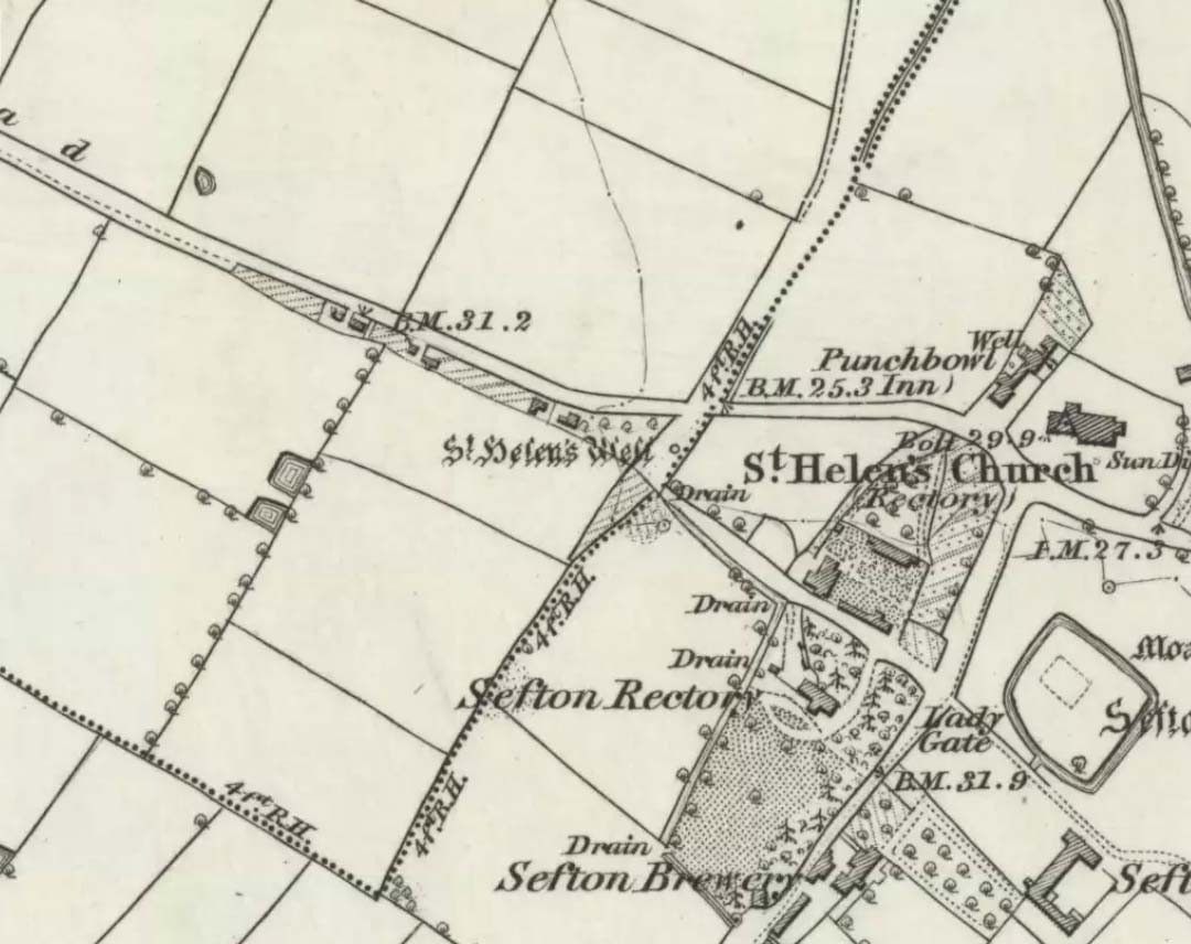
It is best to start at the Punch Bowl Inn car park, Sefton, then travel a short distance along Lunt Road by St Helen’s church. A footpath/lane is reached where a barrier stands and about 10 metres opposite the main road beneath the undergrowth is St. Helen’s holy well, or what remains of it.
Archaeology & History
St Helen’s Well on 1850 map
The well is now, sadly, capped off with an inscribed stone that recalls ST HELEN’S WELL. The well originally stood inside a rather nice little wellhouse with a pyramid-shaped, overlapping roof, with railings running around it. It was renowned for its icy waters which were especially good for people suffering from rheumatism, sprains, bruising and, also nervous problems. It had a hand pump at the side of the well-house to enable people to drink the water. But all this has now gone, though the church congregation still visit the site on the saint’s feast day and are still hoping that some day the well will be restored again.
It was probably a pre-Christian spring that in the Middle Ages turned into a pilgrimage site, especially so in the 14th century when the church was built close by.
Folklore
In pre-Reformation times it was much in use, but later on and in more recent times it had become a wishing well; pins were thrown into the well by young folk. Apparently, if the pin could be seen at the bottom of the well a favourable outcome was likely with regard to good luck in a forthcoming marriage by a couple much in love.
Addenda:
To complement Ray’s entry, here are Mr Taylor’s notes from his Ancient Crosses and Holy Wells (1906), in which he wrote the following:
“This celebrated spring rises at a distance of three hundred yards in a westerly direction from Sefton Church. In the year 1891 the well was walled round, and a handsome canopy placed over it, from the designs of Mr John Douglas, at the cost of William Philip, fourth earl of Sefton. The traditions connected with this holy well are thus graphically summed up in the History of Sefton:-
“”We must not omit to mention St Helen’s Well, which springs near the first cottage in the Thornton Road, beyond the inn. Formerly a ‘pad-road’ only led from the well to the church, the Thornton Road passing through the Rectory grounds. In the Churchwarden’s accounts we find several items of expenditure incurred for the keeping in order of St Helen’s Well. Thus we read in 1758: ‘For a new Dish and Chain for S. Ellen’s Well, 2/-.’ Ashcroft [writing about the year 1819] tells us ‘that this well was once in great repute for curing rheumatism, strains, bruises and weaknesses of the nerves. It has no mineral quality, however, and he remarks that its principal virtue seems to have been its coldness.’ In different times great respect was paid to wells ’eminent for curing distempers upon the Saint’s Day whose name the well bore,’ and it was once the custom to decorate the wells of Holy Thursday with boughs of trees, garlands of flowers, etc, places in various devices, and after service in the church the parson and singers repaired to the well, where they sang psalms and prayed. The bottom of the well, which is of no great depth and very clear, may generally be strewn with pins which are dropped in by superstitious young country folks to denote to them the probability of their marriage, which is said to be near if the pin falls pointing towards the church. Pins and pebbles were often dropped into wells, and the circles formed thereby on the surface of the water (or the question whether the water was troubled at all) were used as omens by which the observers drew inferences of future events. Mr Hampson, in his Medii Ævi Kalendarium, says: ‘I have frequently seen the bottom of S. Helen’s Well, near Sefton, Lancashire, almost covered with pins, which I suppose must have been thrown in for like purposes.'”
“…Mr Gregson wrote: ‘With regard to the curious frequency of well dedication to S. Helen, I formed a theory many years ago that the S. Helen of the county of Lancaster is not unconnected with the Celtic S. Elian, who is a frequent patron saint of wells in North Wales. Do they not both draw a common ancestry from Ella, the water sprite?'”
References:
Caroe, W.D. & Gordon, E.J.A., Sefton: A Descriptive and Historical Account, Longmans Green: London 1893.
Taylor, Henry, The Ancient Crosses and Holy Wells of Lancashire, Sherratt & Hughes: Manchester 1906.
In the old Hundred of West Derby in what was once Lancashire (them there political types shifting boundaries for their own greasy deeds) still remains to this day the trickling remains of old Oswald’s sacred spring, close to the Hermitage Green, which is thought to have gained its named after just such a hermit living hereby and who, no doubt, frequented or looked after this holy well for both refreshment and spiritual sustenance.
Named after the once-pagan King of Northumbria — who was later patronized and regressed to the cultus of a saint — the well was said to be close to an ancient palace, which was later moved when the King regressed into christendom. The well itself was said to have been created through the tradition that the very Earth here possessed healing powers so renowned that people came from many miles to collect and take it for its sacred and medicinal qualities. In Henry Taylor’s (1906) magnum opus he told:
“A writer in The Antiquary twenty years ago (vol.3, p.261) described it as having a very modest appearance for so famous a spot, looking merely like a hole into the hillside. The writer goes on to say, “Passing through a small cottage garden, a well-trodden path leads to the well, which is merely a fosse, as described by Bede, and, situated as it is at the bottom of a tolerable declivity, derives its supply from the drainage of the upper ground rather than from any spring. The water is not very bright, but the well is substantially walled inside, and two or three deeply worn steps lead to the water.”
“The Venerable Bede gives an account of numerous miracles which took place at St. Oswald’s Well. He says: “After which period Oswald was killed in a great battle by the same Pagan nation and Pagan King of the Mercians who had slain his predecessor Edwin at a place called in the English tongue Maserfield in the 38th year of his age on the 5th day of the month of August. How great his faith was towards God, and how remarkable his devotion, has been made evident by miracles since his death; for in the place where he was killed by the pagans…infirm men and cattle are healed to this day. Whereupon many took up the very dust of the place where his body fell, and putting it into water did much good with it to their friends who were sick. This custom came so much into use, that the earth being carried away by degrees, there remained a hole as deep as the height of a man… Many miracles are said to have been wrought in that place, or with the earth carried from thence; but we have thought it sufficient to mention two, which we heard from our ancestors.””
References:
Taylor, Henry, The Ancient Crosses and Holy Wells of Lancashire, Sherratt & Hughes: Manchester 1906.


")
")

")