Described by Tam Ward and Douglas Graham (1989) as “the only surviving standing stone in Clydesdale” (which isn’t quite true), this lovely looking monolith, leaning to one side, appears to have several cup-markings on its surface, but they’re actually Nature’s handiwork. The stone aligns to the hill a short distance north, Bodsbury Hill, upon which a fortress was later built sometime in the Iron Age.
I must have a wander round this region sometime: there’s some very attractive place-names nearby crying out for archaeo-attention to rub myself up and down upon!
References:
Royal Commission on the Ancient & Historic Monuments of Scotland, Lanarkshire: An Inventory of the Prehistoric and Roman Monuments, HMSO: Edinburgh 1978.
Ward, Tam & Graham, Douglas, Ancient Monuments of Clydesdale, CDC: Lanark 1989.
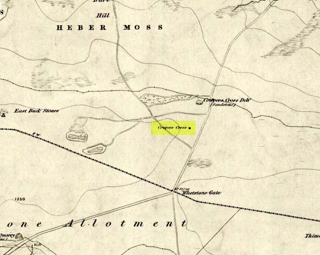
From Ilkley town, head up the road as if you’re going to White Wells but keep following the moorland road up towards Whetstone Gate and the TV masts on the very tops (you’ll have to walk the last half-mile). Shortly before you get them, you can’t miss this relic by the track-side on your right-hand side.
Archaeology & History
Possibly a christianised monolith, erected here in an attempt to divert local people away from the impressive Badger Stone where they may have held springtime gatherings. There used to be an old monolith laid on the ground a few yards away from the cross, which may have stood upright before the cross was erected. Also on the south-facing side of the cross were four cup-markings, indicating great age. These may also have been added when the cross was erected. (We know this occurred at other sites in the region, e.g., Churn Milk Joan, Midgley Moor, where such cup-marks were added sometime in the 15th or 16th century.) However, thanks to some idiotic halfwits in more recent years going up here and vandalizing Cowper’s Cross, the prehistoric cup-markings that were on this relic have been destroyed. The upright shaft of the cross that’s here now is a re-worked gatepost that replaced the old shaft with its authentic ‘pagan’ carvings.
1920s postcard of the Cross
But it’s had other bits of bad luck through the years. The site was struck by lightning many years back, splitting the stone in half, but has since been rebuilt and stands adjacent to its original position, right next to the old Roman road that crosses Ilkley Moor. Historian Allan Butterfield suggested this site to have originally been an old boundary markstone, christianised many centuries ago. The name ‘Cowper’ derives from the local Ilkley family of Cawper.
Those of you interested in the early christian history of these moors should also have a look at the little-known Black Knoll Cross, less than a mile south of here in the middle of Morton Moor.
Folklore
Folklore relates that markets were held at this old stone cross many years ago. This gives added weight to the idea that the nearby cup-and-ring marked Badger Stone, where markets were probably held around the time of the equinoxes, was the original site for such gatherings. Note that another site, the Reva Hill Cross, on the eastern side of this moor, has much the same history.
References:
Bennett, Paul, The Old Stones of Elmet, Capall Bann: Chieveley 2001.
Cowling, E.T., Rombald’s Way, William Walker: Otley 1946.
Go through Laycock village and take the left turn along the lovely, hidden country lane towards Slippery Ford (called Todley Hall Road) until you get near the end of this beautiful wooded valley (called Newsholme Dean). Just by Grey Stones Hill, on your left, is a track heading down to a large farm building with numerous rocks and boulders in the fields either side of you. Stop! – and look in the field on the right.
Archaeology & History
Cluster of cup-marks
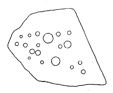
This particular stone is in the field to the right of the track, over the wall, right near the top of the field. Described for the first time in Boughey & Vickerman’s (2003) survey where they describe “at least eight cups” on the rock; and it’s listed on the MAGIC Map survey as having 6 cups — which are the ones you can plainly see on the very top edge of the stone. What may be three other faint ones can be discerned on the sloping sides of the rock.
Cob Stone Field carving
Another ‘possible’ cup-marked stone can be seen lower down the field, past the large Cob Stone. There is also another cup-marked stone in the adjacent field at SE 00610 40841 (listed as stone no.2 in Boughey & Vickerman, 2003) with apparently 17 cups on the large rock there, but this can be difficult to see unless lighting conditions are just right.
References:
Boughey, Keith & Vickerman, E.A., Prehistoric Rock Art of the West Riding, West Yorkshire Archaeology Service 2003.
Pretty easy to get to. It’s in one of the fields above the old farmhouse of Boreland on the western edge of Fearnan, a couple of hundred yards away on the other side of the road from the Clach an Tuirc.
Archaeology & History
Clach-na-Cruich in 1884
In the field we find this great chair-shaped boulder with a great ‘bowl’ on it where the seating section is, and on its top and sides are a few cup-markings — MacMillan (1884) noted seven of them, two of which had half-rings around them, “associated together in a singular manner, and forming a figure like the eyes of a pair of spectacles.”
Folklore
Regarded in local legends to be an ancient initiation seat, this was taken over and ordained as being the seat of St. Ciaran at some time when the Celtic church started having influence up here.
The ‘seat’ of this great stone regularly fills up with rainwater and was, wrote William A. Gillies, “regarded as an effectual cure for measles, and there are persons still residing at Fearnan who were taken as children to drink from the water in the hollow of Clach-na-Gruich, the Measles Stone.” His lengthy account of the site told:
“In the district of Breadalbane, Perthshire – which has in it the Pool of St Fillans, famous for its supposed power of curing mentally afflicted persons – there are two boulders with water-filled cavities, which have a local reputation for their healing virtues. One is at Fernan, situated on the north side of Loch Tay, about three miles from Kenmore. It is a large rough stone with an irregular outline, somewhat like a rude chair, in the middle of a field immediately below the farmhouse of Mr Campbell, Borland. The rest of the field is ploughed; but the spot on which it stands is carefully preserved as an oasis amid the furrows. The material of which it is composed is a coarse clay slate; and the stone has evidently been a boulder transported to the spot from a considerable distance.
“In the centre on one side there is a deep square cavity capable of holding about two quarts of water. I found it nearly full, although the weather had been unusually dry for several weeks previously. There were some clods of earth around it, and a few small stones and a quantity of rubbish in the cavity itself, which defiled the water. This I carefully scooped out, and found the cavity showing unmistakeable evidence of being artificial. On the upper surface of the stone I also discovered seven faint cup-marks, very much weather-worn; two of them associated together in a singular manner, and forming a figure like the eyes of a pair of spectacles.
“The boulder goes in the locality by the name of Clach-na-Cruich, or the Stone of the Measles; and the rain-water contained in its cavity, when drunk by the patient, was supposed to be a sovereign remedy for that disease. At one time it had a wide reputation, and persons afflicted with the disease came from all parts of the district to drink its water. Indeed, there are many persons still alive who were taken in their youth, when suffering from this infantile disease, to the stone at Fernan; and I have met a man not much past forty, who remembers distinctly having drunk the water in the cavity when suffering from measles.
“It is is only within the lifetime of the present generation that the Clach-na-Cruich has fallen into disuse. I am not sure, indeed, whether any one has resorted to it within the last thirty years. Its neglected state would seem to indicate that all faith in it had for many years been abandoned.”
References:
Gillies, William A., In Famed Breadalbane, Munro Press: Perth 1938.
MacMillan, Hugh, ‘Notice of Two Boulders having Rain-Filled Cavities on the Shores of Loch Tay, Formerly Associated with the Cure of Disease,’ in PSAS 18, 1884.
One of the best known supernatural creatures in the Scottish Highlands and Islands was one called the Glaistig: an elemental described variously as, “a thin, grey woman with yellow hair reaching to her heels and attired in green raiment”; or a deity both beneficial and dangerous, “often described as half-woman, half-goat.” Katherine Briggs (1979) wrote that sometimes this creature
“sometimes has the attributes and habits of the Cailleach Bheur, sometimes assumes animal form, often that of a goat, but more often she is described as half-woman, half-goat.”
Something decidely shaman-like!
In many of the places where she was found, she would tend for the cattle and in order to appease her, local people would pour milk into the hollowed stones by which she lived (at some places these were cup-and-ring stones). The Iona Glaistig was no exception. The great Scottish writer A.A. MacGregor (1947) mentioned this creature and its stone in one of his classic books, saying:
“In the shieling days of Iona when, during the summer months, the inhabitants of the east end and of the west end of that island were wont to pasture their cows alternately for fourteen days on the common grazing at a spot known as Staonnaig, a Glaistig dwelt in a hollow rock near at hand. For this Glaistig, the Iona women at milking-time each evening poured a little milk on what is still pointed out at the Glaistig’s Stone.”
This “pouring of milk” onto hollows in stones is a custom found in cultures from Europe eastwards into India and, no doubt, even further afield. The precise whereabouts of this sacred stone remains hidden.
References:
Briggs, Katherine, A Dictionary of Fairies, Penguin: Harmondsworth 1979.
MacGregor, Alasdair Alpin, The Peat Fire Flame, Ettrick Press: Edinburgh 1947.
Troublesome really, as it’s got lost somewhere amidst the undergrowth. From the valley bottom at Apperley Bridge, take the road-then-track which goes up thru the Calverley Cutting (as locals call it), turning left along the dirt-track just as the track begins to slope uphill. Go past the detached house in the edge of the trees and shortly past there is a small footpath taking you into the trees on your left, Walk down and along here, near the bottom of the tree-line above the walling. If you find it, let us know!
Archaeology & History
Included in Boughey & Vickerman’s (2003) survey as ‘stone 12’ – it was first described by Sidney Jackson in 1954, who later gave us a map and drawing of the stone. I looked for it several times x-number of years back, but never found it (though was led astray a little by the profusion of Amanitas in the locale!). Comprising at least 18 cup-markings on a generally flat rock surface, to this day the carving remains unfound, though is probably under the herbage hereabouts. The same fate seems to have befallen the West Woods 1 and West Woods 2 carvings in another part of the same woods. Does anyone know what’s become of them?
References:
Bennett, Paul, “The Undiscovered Old Stones of Calverley Woods,” in Earth no.2, 1986.
Boughey, Keith & Vickerman, E.A., Prehistoric Rock Art of the West Riding, West Yorkshire Archaeology Service 2003.
Jackson, Sidney (ed.), ‘Calverley Wood Cup-Marked Rock,’ in Bradford Cartwright Hall Archaeology Group Bulletin, 1:1, 1954.
Jackson, Sidney (ed.), ‘Cup-Marked Boulder in Calverley Wood,’ in Bradford Cartwright Hall Archaeology Group Bulletin, 1:7, 1955.
Jackson, Sidney (ed.), ‘Cup-and-Ring Boulders near Calverley,’ in Bradford Cartwright Hall Archaeology Group Bulletin, 1:16, 1956.
From Todmorden go east on the A646 for less than a mile and take the Cross Stone road on your left. Keep going all the way up till you hit the moorland edge road, where you’ll see the Great Rock (a massive boulder right by the roadside). Then go down Eastwood Lane, past the house where the lane swings right and here you’ll see a stile in the wall on the right (just after the next lane on your left). Walk along this path, over the stiles in the walling until you reach a wooden stile. The carving is hereby!
Archaeology & History
This carving was described just once by Mr J.A. Heginbottom (1979) as, “a small cup-marked boulder in a stile 100 metres east of Bent Head, Todmorden.” A small, innocuous stone used in the drystone walling, it gives the distinct impression of being one of the many ‘portable’ cup-marked stones typical of those found in prehistoric cairns and other tombs — but the record-books speak of no such remains here; and various ambles about in search of such a potential tomb have drawn a blank. Nevertheless, the cup-markings here are pretty obvious once you see ’em (assuming the daylight aint overcast, which can hide the carvings sometimes). About 2 feet long, about a foot wide and a foot high, this cup-marked portable is similar in size and form to the Nine Stones cup-marking, Derbyshire, recently found in walling very close to where an old tomb was recorded (though the Derbyshire one has only 2-3 cups). Certainly worth a look if you’re in the area.
References:
Heginbottom, J.A., The Prehistoric Rock Art of Upper Calderdale and the Surrounding Area, YAS: Leeds 1979.
Upon the heights of Baildon Hill, get to the Dobrudden Farm caravan site. 100 yards up the track leading from it (north), go into the tribbles of grassland immediately to your left. Look around!
Archaeology & History
This is only a small stone and takes some finding when the grasses are long. It’s found upon the once archaeologically rich High Plain with at least 17 cup-markings etched onto its surface. A single prehistoric tomb appears to have accompanied the rock and its cup-marks.
It was first described by Mr Baildon (1913) in his magnum opus; then later catalogued in Hedges (1986) survey, a couple of years after I did my first drawing of this stone.
References:
Baildon, W. Paley, Baildon and the Baildons – parts 1-15, Adelphi: London 1913-1926.
Bennett, Paul, Megalithic Ramblings between Ilkley and Baildon, unpublished: Shipley 1982.
Boughey, Keith & Vickerman, E.A., Prehistoric Rock Art of the West Riding, WYAS: Leeds 2003.
Hedges, John, The Carved Rocks on Rombald’s Moor, WYMCC: Wakefield 1986.
If you wanna find this, get onto the Low Plain north of the Dobrudden caravan park and its about 10 yards off the path running north from there, not too far from the other Baildon Hill carvings. Scramble about a bit & you’ll find it.
Archaeology & History
W.P. Baildon’s early sketch
Don’t ask me why, but I really like this carving. It’s one of the many I first saw on these moors when wandering about up here when I was 10-12 years old — and they had an effect on me. I call this one of the “primary design” stones, i.e., a number of CRs on this moor (and everywhere else for that matter) appears to have a central design feature. (I’ll point out the others as I post ’em) Some folk think it’s just the slant of the local rock-artist…I think it’s summat a bit different… Local astronomer Gordon Holmes (1997) found a similar pattern here and thought they may have represented star formations, but this is unlikely.
It was first described and illustrated by W. Paley Baildon (1913), way before Mr Jackson (1955) resurrected its attention for archaeologists.
References:
Baildon, W. Paley, Baildon and the Baildons (parts 1-15), St. Catherines: Adelphi 1913-26.
Boughey, K.J.S. & Vickerman, E.A., Prehistoric Rock Art of the West Riding, WYAS: Leeds 2003.
Hedges, John (ed.), The Carved Rocks of Rombald’s Moor, WYMCC: Wakefield 1986.
Holmes, Gordon, 2000 BC – A Neolithic Solstice Odyssey, SASRG 1997.
Jackson, Sidney, ‘Cup-and-Ring Boulders of Baildon Moor,’ in Cartwright Hall Archaeology Group Bulletin, 1:7, 1955.
South of Dobrudden caravan park, heading towards the wall, you’ll stumble across this old carving in the tribbly grass. Zigzag about and keep your eyes peeled!
Archaeology & History
First described by W. Paley Baildon in his monumental 15-part study (1913) of the region, this carving was then later included in John Hedges (1986) survey as ‘Baildon stone 19.’ It was then catalogued as stone 146 in Boughey & Vickerman’s (2003) updated and expanded survey.
Modern drawing (after Hedges 1986)
This carving was one of several in the Baildon Moor complex that was thought by local astronomer Gordon Holmes (1997) to possibly represent heavenly constellations, with Pleiades and Cassiopeia being primary contenders amidst the scattering of carved cups on this stone. This was something I explored in my own research on the possible nature of these carvings in the 1980s, but found that although it seemed a good idea, it was pretty unlikely (unfortunately!). The nature of this and other stones related to the other prehistoric remains where, in bygone days, many prehistoric cairns scattered this grassy moorland plain. The carving was more related to the cosmology of death and the psychogeography of spirit worlds: a factor understood at many other cup-and-rings across the country.
References:
Baildon, W. Paley, Baildon and the Baildons – parts 1-15, Adelphi: London 1913-1926.
Boughey, Keith & Vickerman, E.A., Prehistoric Rock Art of the West Riding, WYAS: Leeds 2003.
Cowling, Eric T., Rombald’s Way, William Walker: Otley 1946.
Hedges, John, The Carved Rocks on Rombald’s Moor, WYMCC: Wakefield 1986.
Holmes, Gordon, 2000 BC – A Neolithic Odyssey, SASRG: Baildon 1997.


")
")