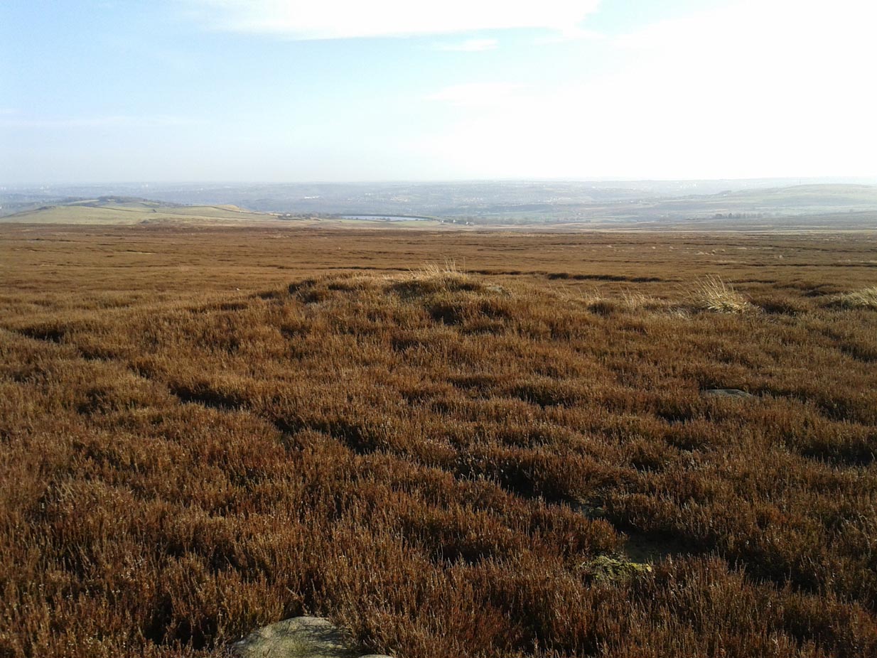
Take the same directions as if you’re going to visit the Black Beck cairn. From here, walk through the heather northwest for about 60 yards. If the heather’s been cleared, you’ll see it low down, otherwise you’re pretty much screwed when it comes to finding this one!
Archaeology & History
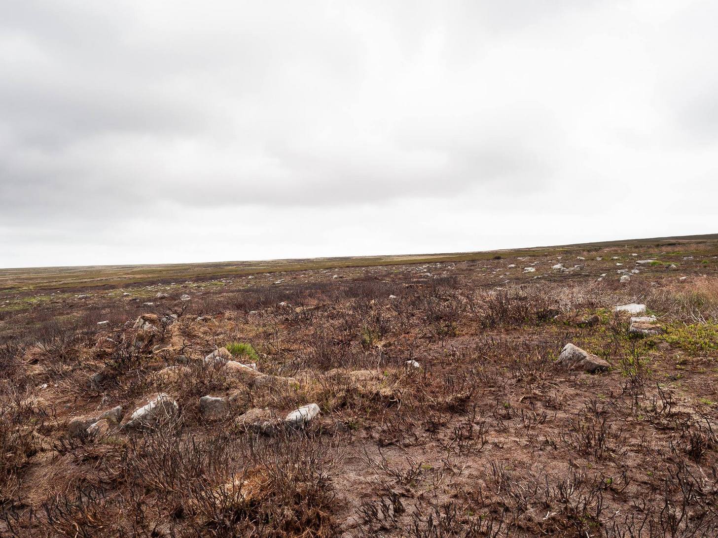
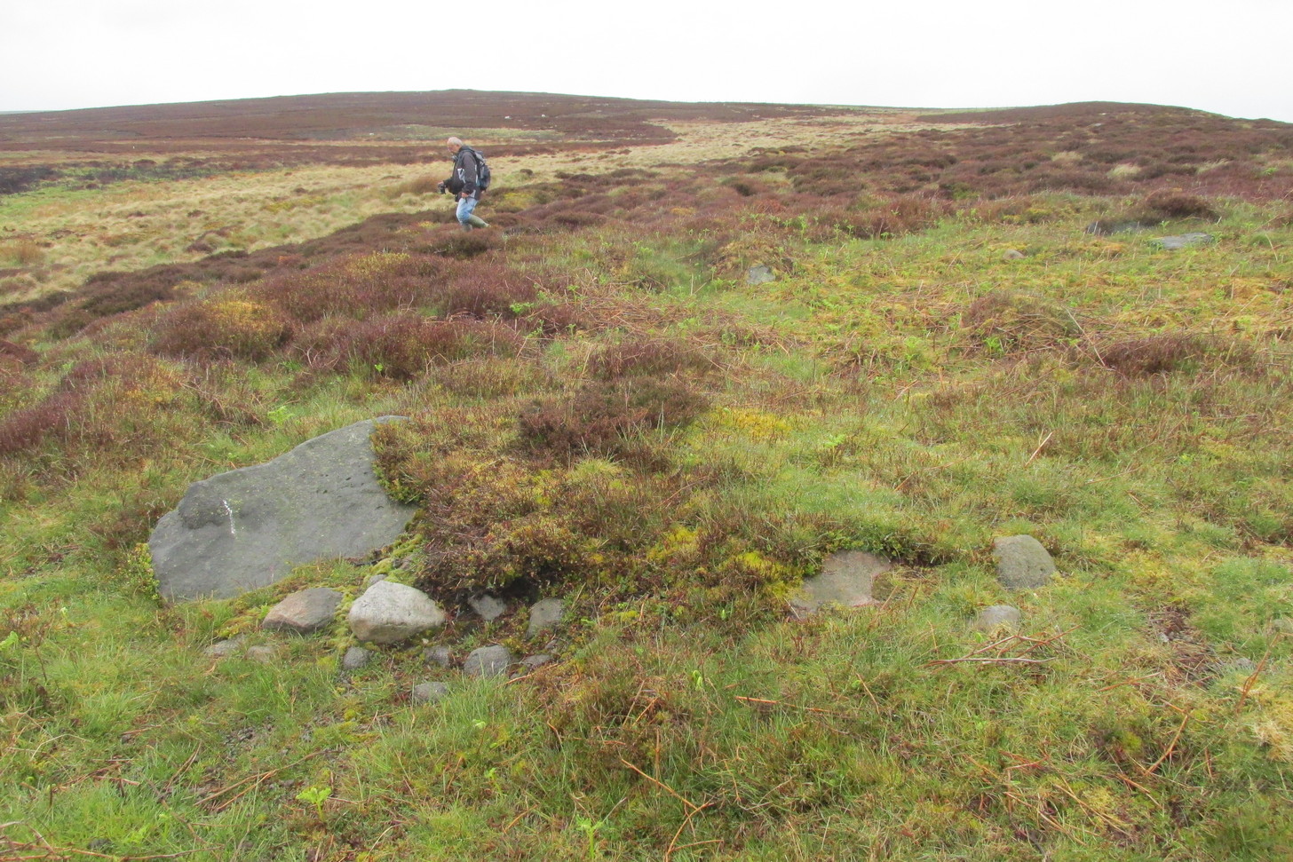
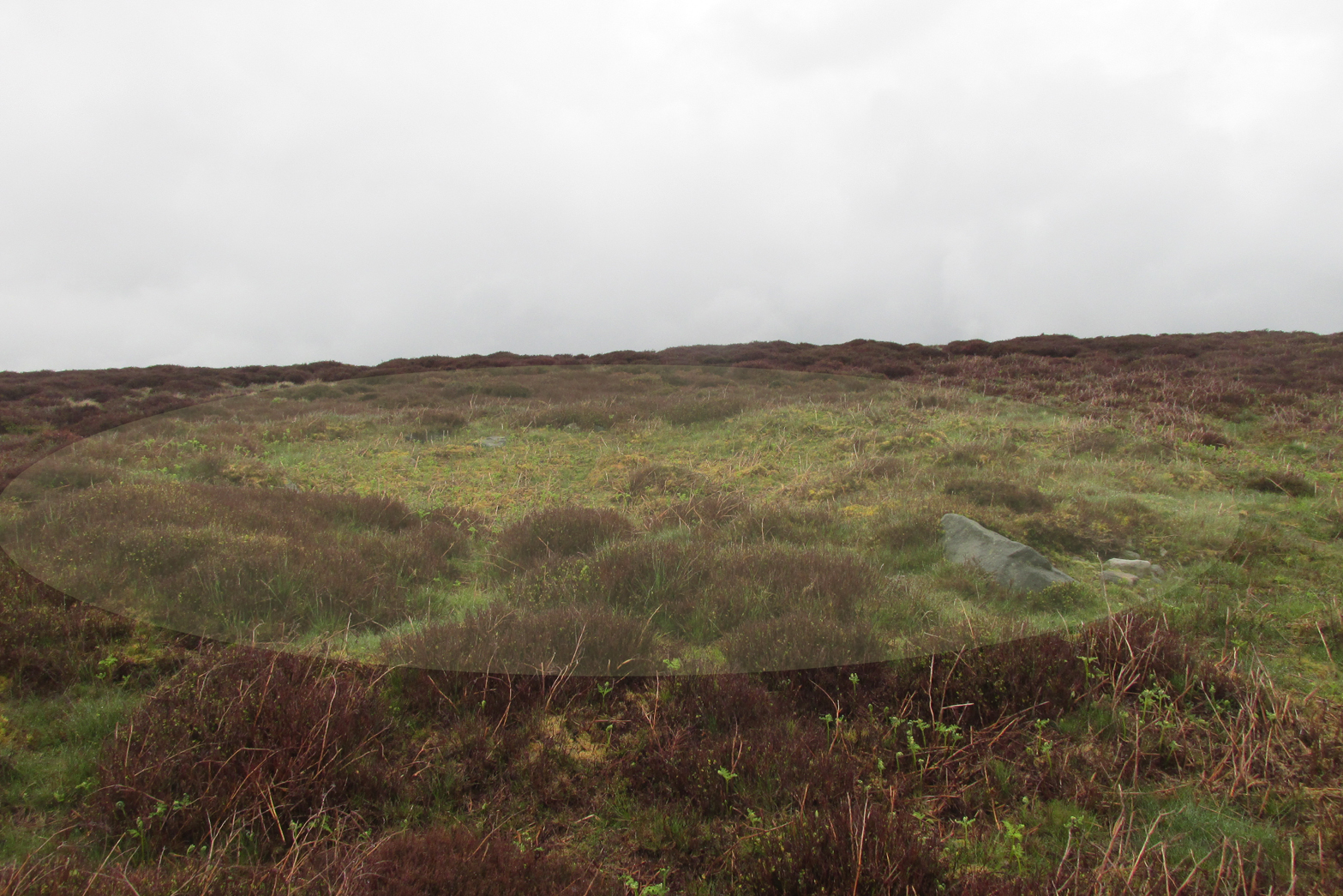
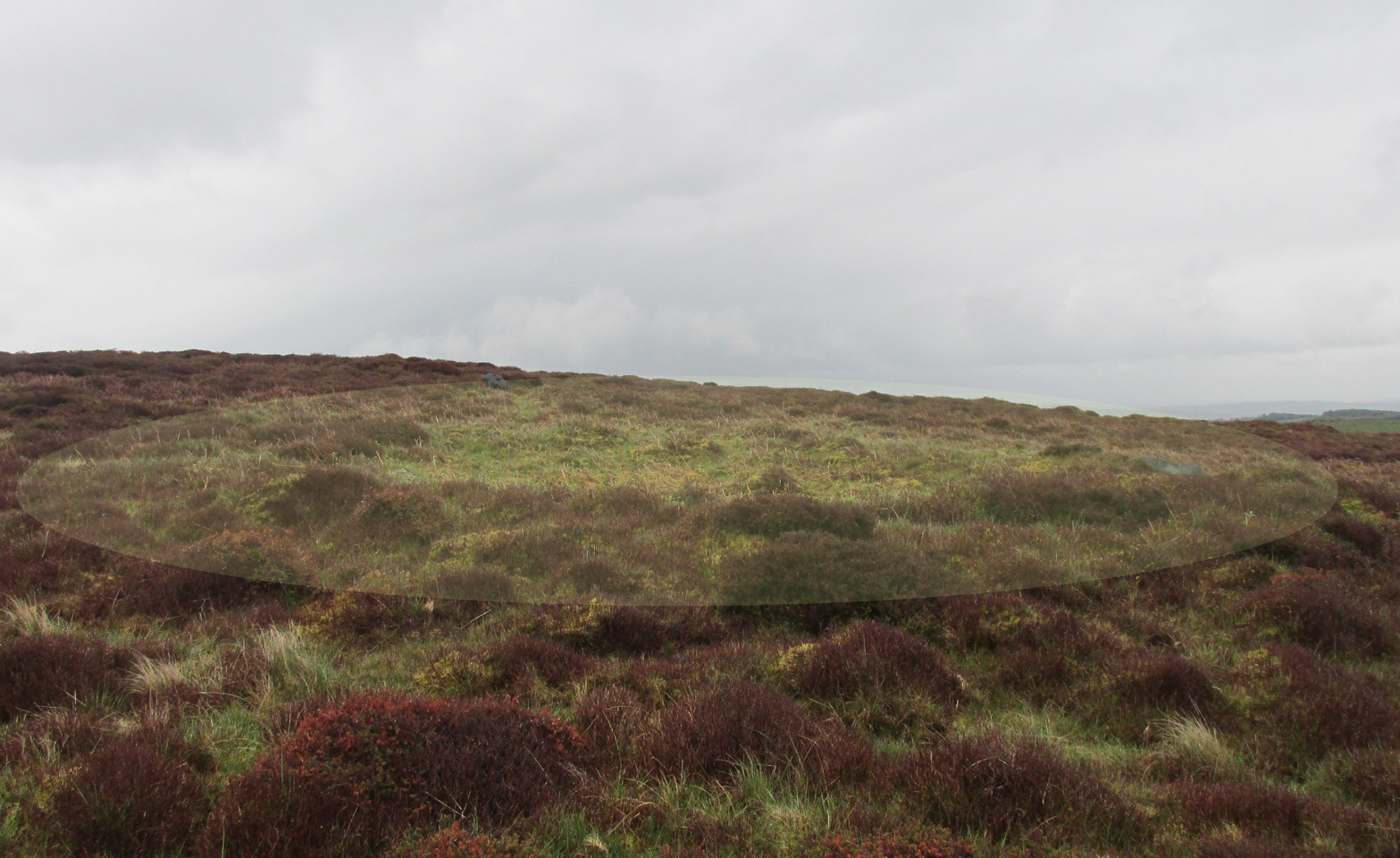
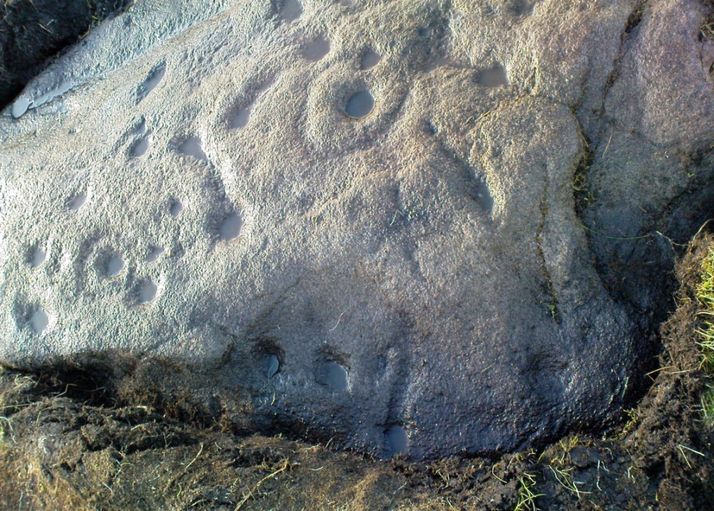
Seemingly in isolation, this low-walled, D-shaped hut circle is presently the only the structure of its kind known to exist on this part of Hawksworth Moor; although to be honest we should expect there to be such structures in the area when we consider the size and proximity of the associated cairnfields immediately north and southeast of here.
Southern arc of wallingNW section of walling; Black Beck tomb to rear
As with most hut circles, it’s nowt special to look at in all honesty. The south side of the structure is rubble walling typical of these structures, curving round as usual; but its more northern section straightens out, creating a D-shaped structure. This line of straight walling seems attached to another, outer parallel wall 3 feet away, creating its very outer edge. The rubble walls themselves average three feet across; whilst the hut circle measures 6-7 yards across. We assume that it was constructed during the same period as the adjacent prehistoric necropolis.
Acknowledgements: With huge thanks, as always, for James Elkington for use of his photos. Also to the evolving megalith and landscape explorer Mackenzie Erichs; and to Linzi Mitchell, for additional input…
Unless the heather’s been burnt back, this takes a bitta finding. Direction-wise, the easiest is from the moorland road above Menston. Go up Moor Lane and then turn right along Hillings Lane. 350 yards on is a dirt-track on your right marked as Public Footpath. Walk up here for two-thirds of a mile—going past where the track goes left to the Shooting Range—to where the track splits. Bear left and after 250 yards you reach a fence on your left where the moorland proper begins. Follow this fence SW for 300 yards until it does a right angle turn. Just before this, you’ll see a large worn overgrown trackway or path running north into the moorland. Walk up here for nearly 100 yards and look around. Best o’ luck!
Archaeology & History
Western arc of earth & stone
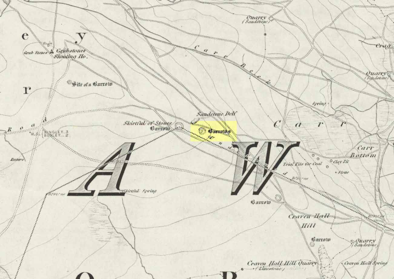
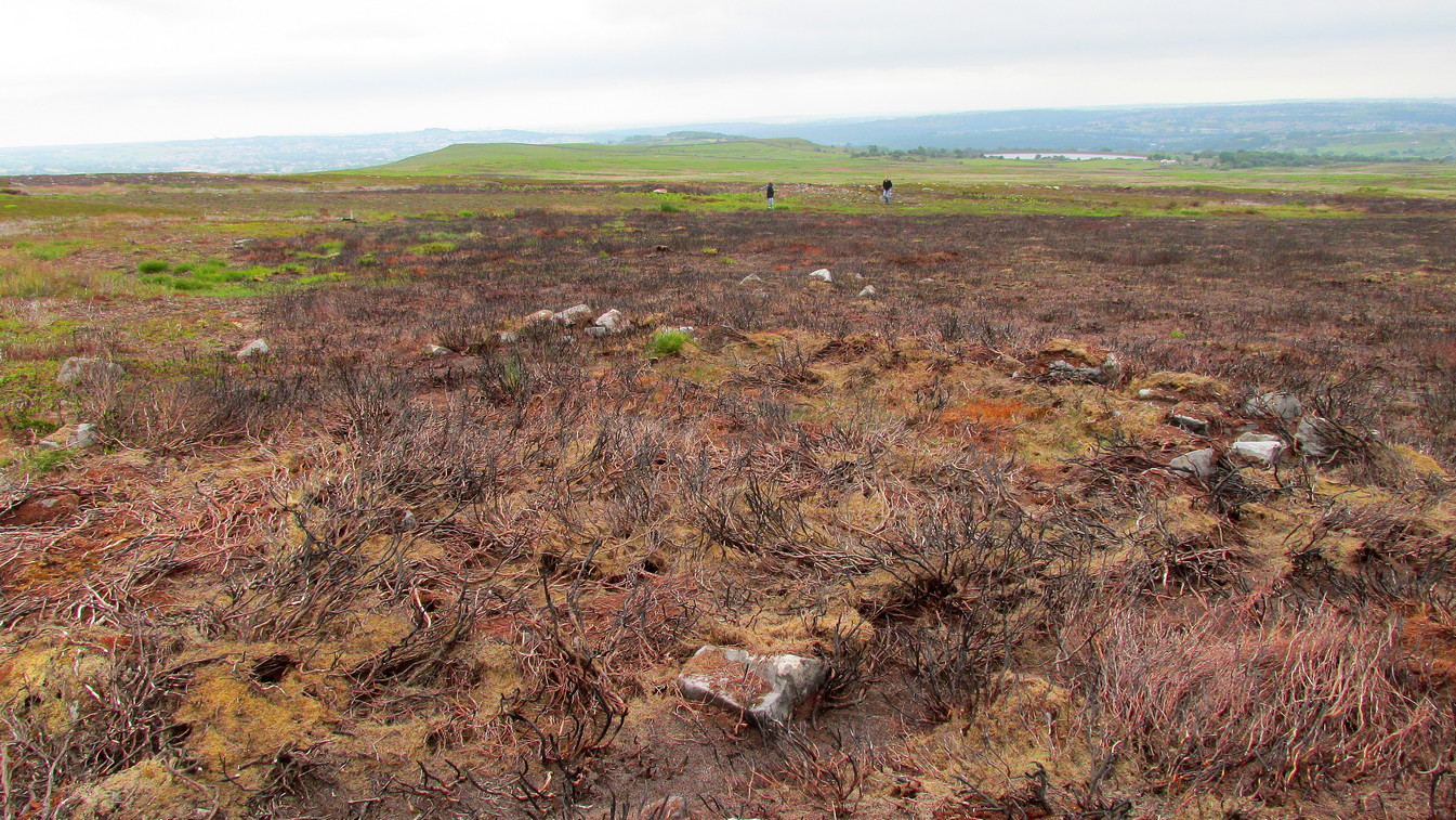
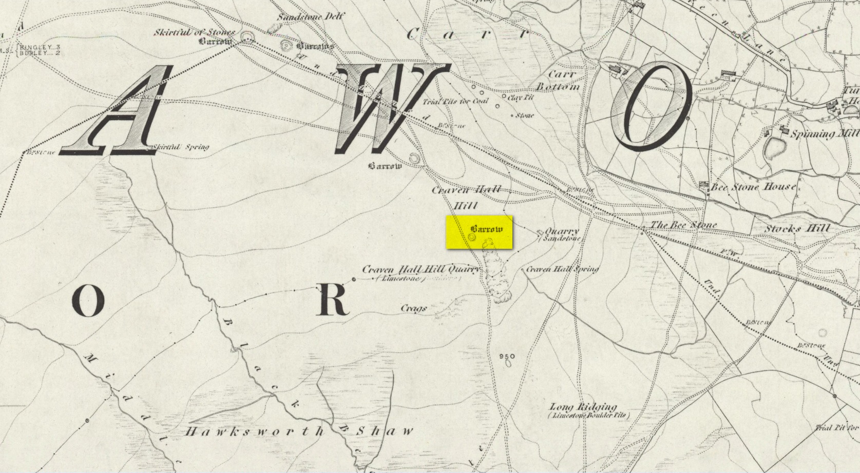
Shown on the 1851 OS-map adjacent to the long prehistoric trackway that runs past Roms Law, the Great Skirtful and other prehistoric sites, the antiquarian wanderings of Forrest & Grainge (1868) came past here and, although didn’t mention the Craven Hall cairns directly, they did write of “a group of barrows” hereabouts, and this may have been one of them. James Wardell (1869) gave an even more fleeting skip, only mentioning “pit dwellings” hereby. A little closer to certainty was the literary attention Collyer & Turner’s (1885) pen gave, where they described, “near the adjoining old trackway, which runs from East to West, will be seen a small barrow”—but this could be either of the Craven Hill sites. And the usually brilliant Harry Speight (1900) gave the place only more brevity….
Structurally similar to Roms Law nearly ¾-mile northwest of here, this little-known and much denuded prehistoric tomb has seen better days. It is barely visible even when the heather’s low—and when we visited recently, the heather was indeed low but, as the photos here indicate, it’s troublesome to see. It’s better, of course, with the naked eye.
Highlighted ring cairn, looking NEHighlighted ring cairn, looking SE
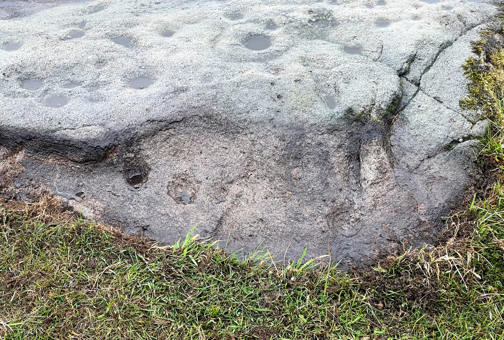
It’s the most easterly cairn in the large Bronze Age necropolis (burial ground) on Hawksworth Moor. Measuring some 12 yards across and roughly circular in form, the ring is comprised mainly of many small stones compacted with peat, creating a raised embankment barely two feet high above the heath and about a yard across on average. A number of larger stones can be seen when you walk around the ring, but they don’t appear to have any uniformity in layout such as found at the more traditional stone circles. However, only an excavation will tell us if there was ever any deliberate positioning of these larger stones. It would also tell us if there was ever a burial or cremation here, but the interior of the ring has been dug out, seemingly a century or two ago…
References:
Collyer, Robert & Turner, J.H., Ilkley: Ancient and Modern, William Walker: Otley 1885.
Faull, M.L. & Moorhouse, S.A. (eds.), West Yorkshire: An Archaeological Guide to AD 1500 – volume 1, WYMCC: Wakefield 1981.
Forrest, C. & Grainge, William, A Ramble on Rumbald’s Moor, among the Rocks, Idols and Altars of the Ancient Druids in the Spring of 1869, H. Kelly: Wakefield 1868.
Speight, Harry, Upper Wharfedale, Elliott Stock: London 1900.
Wardell, James, Historical Notes of Ilkley, Rombald’s Moor, Baildon Common, and other Matters of the British and Roman Periods, Joseph Dodgson: Leeds 1869.
Take the same directions as if you’re visiting the Great Skirtful of Stones giant cairn on the boundary of Burley and Hawksworth. Cross the wire fence on its southern-side and, cross the (usually overgrown) prehistoric trackway 50-60 yards away. Keep in the same direction onto the pathless moor for about the same distance again, zigzagging back and forth, keeping your eyes peeled for some small overgrown rocky rises. You’ll find ’em.
Archaeology & History
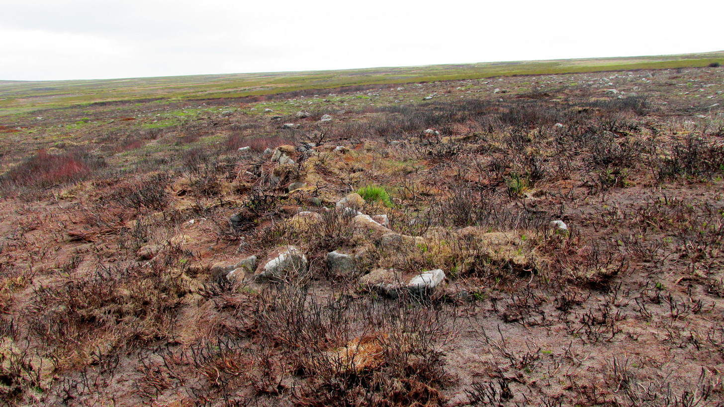
Not to be confused with the much larger Bronze Age graveyard further south on the same moorland, this little-known prehistoric cemetery has had little of any worth written about it since the 19th century and—like many sites on these moors—has received no modern archaeological attention.
Close-up of one of the cairnsTwo of the cairns, looking NW
On my last visit to this site with James Elkington in 2015, only four of the heather-clad cairns were visible; but if you explore here after the heather has been burned away, a half-dozen such tombs are found in relatively close attendance to each other. They are each about the same size, being roughly circular and measuring between 3-4 yards across, 10-12 yards in circumference and a yard high at the most. As you can see in the attached images, they are quiet visible even when the heather has grown on them.
Another cairn in this group
This small cairnfield may stretch across and link up with the secondary cairnfield a half-mile to the southwest. More survey work is required up here.
As with the circle of Roms Law and the Great Skirtful of Stones, this relatively small cluster of cairns seems to have had a prehistoric trackway approaching it, running roughly east-west. A short distance west are the much-denuded waters of the Skirtful Spring.
References:
Bennett, Paul, The Old Stones of Elmet, Capall Bann: Milverton 2001.
Faull, M.L. & Moorhouse, S.A. (eds.), West Yorkshire: An Archaeological Guide to AD 1500 (4 volumes), WYMCC: Wakefield 1981.
Wardell, James, Historical Notes of Ilkley, Rombald’s Moor, Baildon Common, and other Matters of the British and Roman Periods, Joseph Dodgson: Leeds 1869. (2nd edition 1881).
Acknowledgements: Huge thanks to James Elkington for use of his photo in this site profile.
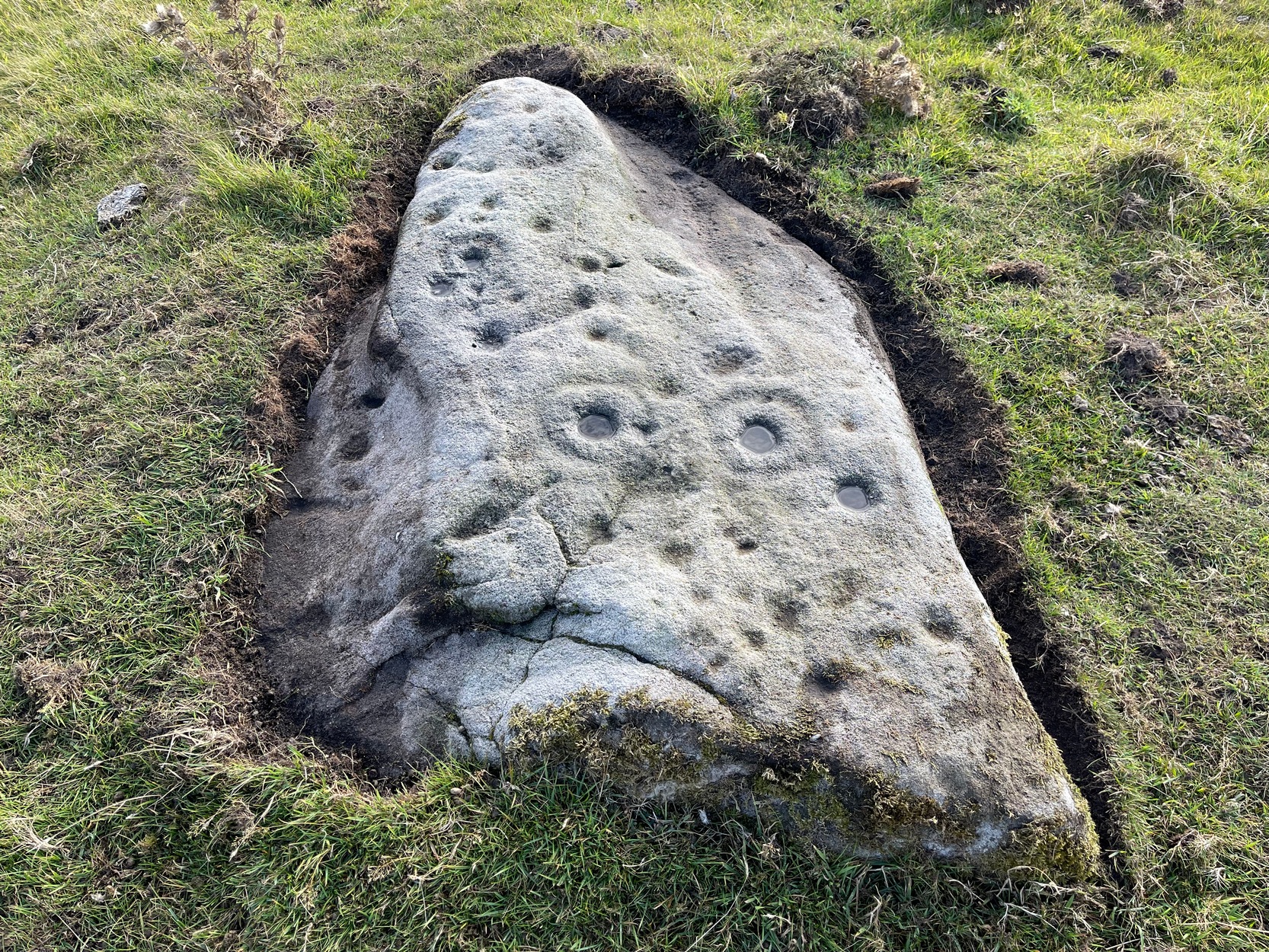
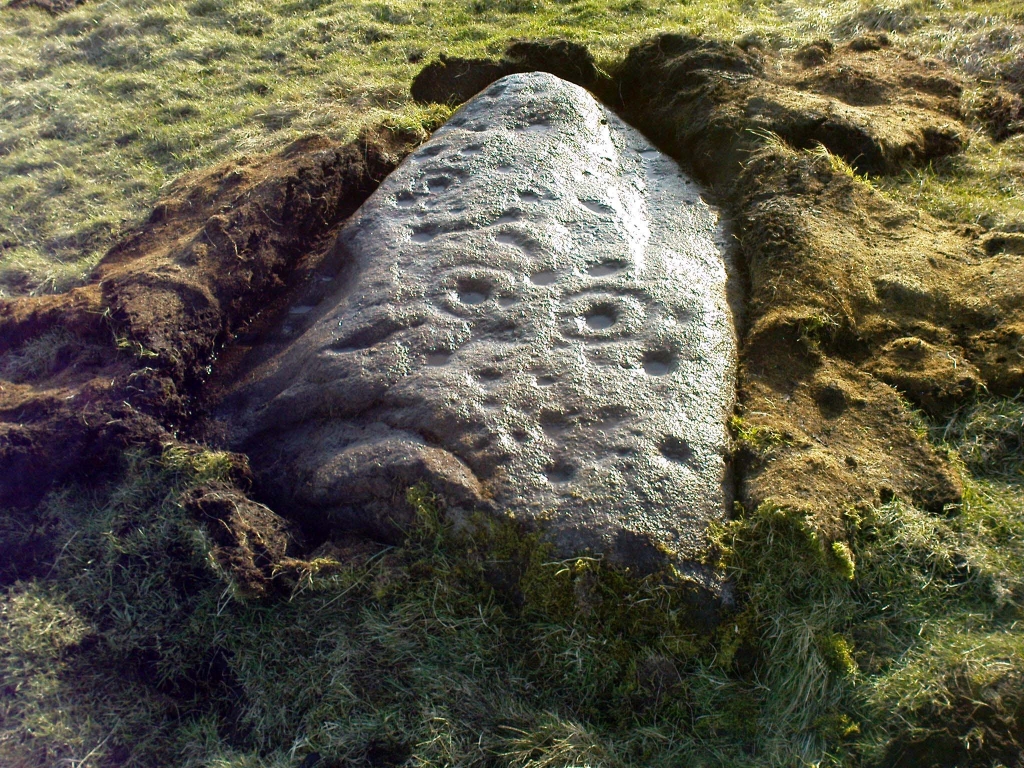
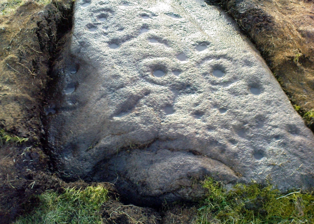
Probably the easiest (direction wise) is if you’re coming from Dick Hudson’s public house on the southern road surrounding Rombalds Moor. From the pub, head left (east) along Otley Road (passing Weecher reservoir) for 1.9 miles (3.1km) until you reach Reva reservoir where a track leads you to the waters. A small parking spot is on the left-side of the road. From here, go through the gate and along the footpath across the field for nearly 300 yards to the next gate; go through here and walk to your right for about 60 yards where uyou’ll reach a small straight dyke (keep your eyes peeled!) running NW (to your left): walk along here for nearly 200 yards until it hits another shallow dyke bearing right; follow this dead straight for 35 yards after which it changes direction, but you need to keep walking straight on forward for another 60 yards or so. Look around!
Archaeology & History
First photo of the carving
This carving is one in a cluster of previously unrecorded petroglyphs, uncovered in the summer of 2011 during a Northern Antiquarian bimble on the northern edge of Rombald’s Moor. The carvings were found as a bi-product of uncovering a previously undiscovered cairn circle, close to the Twelve Apostles stone circle. In assessing and exploring the newly-found circle, it was noticed that a small opening in the near horizon highlighted a rise in the landscape barely a mile away. This ‘opening’ in the land was not visible if you walked 25 yards either side of the cairn circle – but was very notable at the circle itself.
“We need to have a look at that site,” I said. “It’s position looks to have been relevant to this circle.” (or words to that effect) And a couple of weeks later we met up and walked to the place in question.
Fraggle Rock carving, looking westFraggle Rock carving, looking south
Within five minutes we came across a couple of previously unrecorded cup-marked stones, of simple design, right in line with the cairn circle. As we walked around this spot, then headed back in the direction of the circle, a cluster of small stones were noticed on the slope. One had what looked like a single cup-marking near its edge, but the rest of the rock was completely covered in vegetation. Paul Hornby and Michala Potts had, by now, already found several other previously unrecorded cup-marked stones close by; but as I carefully rolled back the vegetation at the edge of this particular rock, cups-and-rings and carved lines seemed to be covering most of its surface. It was a good one!
Face on the Fraggle Rock
We called it the Fraggle Rock after noticing that when you look at the stone from one end, the two main cup-and-rings are likes two large eyes carved above a large natural down-turning ‘mouth’ feature, similar to some of the creatures’ faces on the muppets or the similar kid’s TV show, Fraggle Rock! (sad aren’t we!?) The photo here shows you what we mean.
The primary design consists of at least 3 cup-and-rings, 2 partial cup-and-rings, 28 cups and several carved lines along which some cup-markings are linked to others. The most notable of the carved lines is the longest (barely visible in the photos), running from a single cup-mark at the southernmost rounded end of the stone, almost straight and parallel with a natural ridge or dip along the rock, until it meets the largest of the cup-and-rings (one of the eyes on the Fraggle’s face!). Don’t ask me why, but for some reason this long faint line seemed the most perplexing element of the carving.
Eastern edge with low cupsCup-marks on rock edge
Most of the design is carved on the upper face of the stone, but a small part of the rock dips into the ground on its eastern side and a small group of cups and a single carved line, in a very good state of preservation, are etched right at the edge of the stone. Unusual. Another faint cup-and-ring is less than 100 yards west; and a fascinating cup-and-lines stone, with at least four long carved ridges running like hair from the top of the stone into the Earth, is a short distance to the north. A number of others are in this and adjacent fields.
From the famous Dick Hudson’s pub on the south side of Ilkley Moor, take the road right (east) for a half-mile until you reach the large Weecher Reservoir just off the roadside on your right. Less than 300 yards past the reservoir, a footpath takes you onto the moor itself. Walk up the path for about ⅔-mile — crossing one wall, then walking roughly parallel with another on your right — until you reach a crossing of paths where there are 2 gates or stiles. Take the lower of the two stiles, through the wall, but below the fence. You’ll see an awful Yorkshire Water cover, which has just about destroyed the once-fine well that had always flowed here. Below this, by the wallside, are the trickling remains of our old healing spring.
Archaeology & History
When I was a young boy, Horncliffe Well was the site we would visit every weekend as our first stopping-spot on our regular ventures exploring these moorlands — “from Wrose to Rombalds,” as we use to call it! The old well was always very plentiful, strong-flowing, cold and truly refreshing. It was undoubtedly the best water source on the entire Rombalds Moor region, never drying up. Even in the great droughts of 1976 and 1995, after all others had just about failed, the waters at Horncliffe were still flowing as strong as ever, as they had always done. But not anymore…
Edna Whelan’s old drawing
First described in land records of 1273 CE, this has always been a well of great repute and oral tradition told that this great old well never ran dry. It marked the ancient boundary point where the moorlands of Hawksworth, Burley and Bingley all meet. By name alone it is associated with the nearby and curious Horncliffe Circle, whose status itself is unclear (the circle seems more a place of refuge or living than a true ritual site).
Horncliffe House around 1801
The remains of old buildings on the flat just above where the waters once flowed were built in much more recent centuries. The building appears to have been started around 1799, for E.E. Dodds (1985) told that in 1800 it was used as a school for several years by local teacher Joshua Briggs. J. Horsfall Turner (1907) published a copy of an old drawing of the school, as it was soon after construction.
Horncliffe Well was dug into by the privatized water company known as Yorkshire Water (owned by rich greedy fuckers) in the 1990s, who channelled most of its endless supply away for commercial benefit. When their company was stealing the water from the moors, the workmen snapped an old markstone at its base next to the adjacent Horncliffe House (in ruins). The waters had always flowed fast and freely, but after Yorkshire Water had finished their ‘work’ here, the great majority of Horncliffe’s water supply subsided considerably, leaving walkers, birds and animals to suffer from its demise. In all sincerity, it’s to be hoped that good people someday will visit this once-fine site and return it to its previous healthy status.
Folklore
When we were kids we came here every weekend and got to know the old ranger who we’d meet either here or at the adjacent Horncliffe Circle, 250 yards NNE, where we’d sit and eat. In the mid-1970s, he told us that the old well was once a site where the fairy-folk would play, around Mayday (beltane). And though in later years I’ve sought for any information about this in all early antiquarian books that cover this area, I’ve never found any mention of this tale in print. The old ranger knew the moors and its history better than anyone I’ve ever known and many old stories died with him after his death.
References:
Bennett, Paul, The Old Stones of Elmet, Capall Bann: Chieveley 2003.
Dodd, E.E., Bingley: A Yorkshire Town through Nine Centuries, M.T.D. Rigg: Guiseley 1985.
Laurence, Alastair, A History of Menston and Hawksworth, Smith Settle: Otley 1991.
Turner, J. Horsfall, Idle Upper Chapel Burial Registers and Graveyard Inscriptions, Harrison & Son: Bingley 1907.
Whelan, Edna, The Magic and Mystery of Holy Wells, Capall Bann: Chieveley 2001.
Whelan, Edna & Taylor, Ian, Yorkshire Holy Wells and Sacred Springs, Northern Lights: Dunnington 1989.
Get to the Twelve Apostles stone circle, then walk just 100 yards down the main footpath south, towards Bingley, and watch out for a small footpath immediately to your left. Walk on here and head for the rocky outcrop a half-mile ahead of you. Once past the outcrop, take the first footpath right and walk down for another 100 yards. Stop! – and walk into the heather. The circle’s about 50 yards away! You can of course come from the Menston side of the moor, following the same directions for the Great Skirtful of Stones, but keep walking on for another 200 yards, towards the rocky outcrop again, turning left down the path for 100 yards, before stopping and walking 50 yards into the heath again!
Archaeology & History
Roms Law circle
This is one of my favourite sites on these moors. I’m not 100% sure why – but there’s always been something a bit odd about the place. And I don’t quite know what I mean, exactly, when I say “odd.” There’s just something about it… But it’s probably just me. Though I assume that me sleeping rough here numerous times in the past might have summat to do with it, playing with the lizards, and of course…the sheep… AHEM!!! Soz about that – let’s just get back to what’s known about the place!
Grubstones is an intriguing place and, I recommend, recovers its original name of Roms or Rums Law. It was described as such in the earliest records and only seems to have acquired the title ‘Grubstones’ following the Ordnance Survey assessment in the 1850s. The name derives from two compound words, rum, ‘room, space, an open space, a clearing’; and hlaw, a ‘tumulus, or hill’ – literally meaning here the ‘clearing or place of the dead,’ or variations thereof. But an additional variant on the word law also needs consideration here, as it can also be used to mean a ‘moot or meeting place’; and considering that local folklore, aswell as local boundary records tell of this site being one of the gathering places, here is the distinct possibility of it possessing another meaning: literally, ‘a meeting place of the dead’, or variations on this theme.
The present title of Grubstones was a mistranslation of local dialect by the Ordnance Survey recorders, misconstruing the guttural speaking of Rum stones as ‘grub stones.’ If you wanna try it yourself, talk in old Yorkshire tone, then imagine some Oxford or London dood coming along and asking us the name of the ring of stones! It works – believe me….
The site has little visual appeal, almost always overgrown with heather, but its history is considerable for such a small and insignificant-looking site. First described in land records of 1273 CE, Roms Law was one of the sites listed in the local boundary perambulations records which was enacted each year on Rogation Day (movable feast day in Spring). However in 1733 there was a local boundary dispute which, despite the evidence of written history, proclaimed the Roms Law circle to be beyond the manor of Hawksworth, in which it had always resided. But the boundary was changed – and local people thenceforth made their way to the Great Skirtful of Stones on their annual ritual walk: a giant cairn several hundred yards east to which, archaeologically, there is some considerable relationship. For at the northern edge of the Roms Law circle is the denuded remnants of a prehistoric trackway in parts marked out with fallen standing stones and which leads to the very edge of the great cairn. This trackway or avenue, like that at Avebury (though not as big), consists of “male” and “female” stones and begins – as far as modern observations can tell – several hundred yards to the west, close to a peculiar morass of rocks and a seeming man-made embankment (which I can’t make head or tail of it!). From here it goes past Roms Law and continues east towards the Great Skirtful, until it veers slightly round the southern side of the huge old tomb, then keeps going eastwards again into the remnants of a prehistoric graveyard close by.
In my opinion, it is very likely that this trackway was an avenue along which our ancestors carried their dead. Equally probable, the Roms Law Circle was where the body of the deceased was rested, or a ritual of some form occurred, before taken on its way to wherever. It seems very probable that this avenue had a ceremonial aspect of some form attached to it. However, due to the lack of decent archaeological attention, this assertion is difficult to prove.
A previously unrecognised small single tomb is in evidence to the immediate southeast (5 yards) of the circle. There is also another previously unrecognised prehistoric trackway that runs up along the eastern side of the circle, roughly north-south, making its way here from Hawksworth Moor to the south. The old legend that Roms Law was a meeting place may relate to it being a site where the dead were rested, along with it being an important point along the old boundary line. Records tell us that the chant, “This is Rumbles Law” occurred here at the end of the perambulation – which, after the boundary change, was uttered at the Great Skirtful. This continued till at least 1901.
Northern section of the Ring
Modern archaeological analysis of the site is undecided as regards the actual nature of Roms Law. Ordnance Survey maps show it as an “enclosure” (which is vague); Faull & Moorhouse’s survey (1981) erroneously tell us it had no funerary nature, contrary to Eric Cowling’s (1946) report of finding bones and ashes from the small hole in near the centre of the ring, aswell as the 1880 drawing of the site in Collyer & Turner’s survey (above). And we find the single cairn on the south-eastern edge of the ring indicating burial rites of sorts definitely occurred here. Described variously by previous archaeologists as a stone circle, a ring cairn, cairn circle, an enclosure, aswell as “a rubble-fill wall of a circular house” (by some anonymous member of the West Yorkshire Archaeology Service, who didn’t respond to my queries about this curious assumption), the real nature of Roms Law leans more to a cairn circle site. A fine example of a cup-and-ring stone — the Comet Stone — was found very close to the circle, somewhere along the Grubstones Ridge more than a hundred years ago, and it may have had some relevance to Roms Law.
This denuded ring of stones is a place that has to be seen quite blatantly in a much wider context, with other outlying sites having considerable relationship to it. Simple as! (If you wanna know more about this, check out my short work, Roms Law, due out shortly!)
Describing the status and dimensions here, our great Yorkshire historian Arthur Raistrick (1929) told that:
“The larger stones still standing number about twenty, but the spaces between them are filled with stones of many intermediate sizes, so that one could with only considerable detail of size, etc, number the original peristalith.”
…Meaning that we’re unsure exactly how many stones stood in the ring when it was first built! Although a little wider, the Roms Law is similar in form to the newly discovered ‘Hazell Circle‘ not far from here. The site has changed little since Raistrick’s survey, though some halfwits nicked some of the stones on the southwestern edge of the site in the 1960s to build a stupid effing grouse-butt, from which to shoot the birds up here! (would the local council or local archaeologist have been consulted about such destruction by building the grouse-butt here? – anyone know?) Thankfully, this has all but disappeared and the moorland has taken it back to Earth.
There is still a lot more to be told of Roms Law and its relationship with a number of uncatalogued sites scattered hereby. Although it’s only a small scruffy-looking thing (a bit like misself!), its archaeology and mythic history is very rich indeed. “Watch This Space” – as they say!
Folklore
Alleged to be haunted, this site has been used by authentic ritual magickians in bygone years. It was described by Collyer & Turner (1885) “to have been a Council or Moot Assembly place” — and we find this confirmed to a great extent via the township perambulation records. Considerable evidence points to an early masonic group convening here in medieval times and we are certain from historical records that members of the legendary Grand Lodge of All England (said to be ordained in the tenth century by King Athelstan) met here, or at the adjacent Great Skirtful of Stones giant cairn 400 yards east.
The boundary perambulations which occurred here on Rogation Day relate to events just before or around Beltane, Mayday. Elizabeth Wright (1913) said of this date:
“These days are marked in the popular mind by the ancient and well-known custom of beating the parish bounds, whence arose the now obsolete name of Gang-days, and the name Rammalation-day, i.e., perambulation-day, for Rogation-Monday. The practice is also called Processioning and Possessioning… The reason why this perambulation of the parish boundaries takes place at Rogationtide seems to be that originally it was a purely religious observance, a procession of priest and people through the fields to pray for a fruitful Spring-time and harvest. In the course of time the secular object of familiarizing the growing generation with their parish landmarks gained the upper hand, but the date remained as testimony to the primary devotional character of the custom.”
And the calling of, “This is Rumbles Law” maintained this ancient custom when it used to be uttered here.
Get to the famous Dick Hudson’s pub on the south-side of Ilkley Moor and go east for about 700 yards till you get to Weecher reservoir (posh doods go yachting there). From here cross the road and walk on for 150 yards till you reach the stile which takes you onto the moors. Walk! Follow the footpath and you’ll go over another wall before eventually hitting the beautiful fresh waters of Horncliffe Well (this has never dried up – even in the summers of ’76 and ’95). Sit here for a while before heading for the circle which is on the east-side of the moorland fence just a coupla hundred yards up onto the moor (you’ll cross a coupla streams before reaching the site). You’ll know you’re close when, to your left by the fence, you’ll see a boundary stone with the name ‘Thos. Pulleyn’ engraved on it.
Archaeology & History
Early drawing of Horncliffe Circle (Speight 1898)
Horncliffe is a bittova strange site, inasmuch as we don’t honestly know precisely what it is, nor its age. It used to be categorized as a ‘stone circle’, but this was abandoned many moons ago. The inner circle of this ellipse-shaped monument was thought to have perhaps contained a burial, but Victorian excavations here found no such evidence; no burials have ever been found, though fires were evidently burned in the small central ring.
Nowadays I’m of the opinion that this was more for living-in, than any ritual site. It ‘smells’ like that anyway (modern OS-maps now term it as an ‘enclosure’); and this may be borne out by the ancient name of the trackway travelling north from here called ‘Castle Gate’, meaning ‘entrance or path by the fortification.’ Faint ‘cup-markings’ reported by Harry Speight (1898) on the outer edge of the ring are very likely Nature’s handiwork.
Horncliffe is a double-ringed ellipse structure, surrounded on its northern side by a natural embankment of earth. It was first mentioned in J.N.M. Colls’ (1846) survey, but more was said of it by James Wardell in 1869, who told that,
“there is a circle of stones of various sizes, from three-feet to five-feet in height; they are chiefly set upon their edges and are of sandstone grit. This circle is forty-three feet in diameter and within it there is a smaller circle, composed of stones of the same composition…and set in the same manner.”
A few years later, the Yorkshire literary giant Harry Speight (1898) penned his first words about this curious circle, saying:
“The best example of a stone circle in the vicinity of Bingley lies on the moor close to the parish boundary, on land belonging to Mr Fawkes, of Farnley Hall. It is a complete circle, consisting of about twenty stones, placed close together (a very unusual arrangement), from two to four feet high, the circumference being about 35 yards. An excavation was made in the middle of it some years ago, when bits of flint were found, but no trace of burial. It is built on a slight slope of the moor, facing the south, and is now much concealed by heather. It is, doubtless, the oldest known evidence of man’s handiwork remaining in the neighbourhood of Bingley, and there is small doubt that it was originally intended to fence a burial, such “Druids’ Circles” being primarily meant to enclose places of sepulchre in the same way that walled enclosures came to be adopted round our churchyards. A large flat stone on the top side, about three yards distant, is marked with cups and channels, and probably was in the centre of the circle originally.”
When Arthur Raistrick (1929) visited the circle, his measurements differed somewhat from those of Mr Wardell, telling the site to have diameters of 25 feet (east-west) and 32 feet (north-south), with 46 stones in the outer ring and 17 in the inner circle.
This is one of many sites on these moors that I slept at over the years when I was a kid. It used to be a really peaceful spot that was rarely troubled by other visitors (not sure if it’s still the same though).
Folklore
Although we have nothing specific to the circle, around the nearby Horncliffe Well a coupla hundred yards away we had accounts told us by the old warden whose job it was to look after this moorland, that will-o-the-wisps had been seen here. There is a seeming alignment to the equinoxes from here to Reva Hill – though this is more fortuitous than deliberate. A dowsing survey found aquastats in and around the circle, but no plan of these were ever made.
References:
Bennett, Paul, The Old Stones of Elmet, Capall Bann: Milverton 2001.
Colls, J.N.M., ‘Letter upon some Early Remains Discovered in Yorkshire,’ in Archaeologia 31, 1846.
Raistrick, Arthur, ‘The Bronze Age in West Yorkshire,’ in YAJ 1929.
Speight, Harry, Chronicles and Stories of Old Bingley, Elliot Stock: London 1898.
Although destroyed, to those who wanna check the locale, from Bingley take the Eldwick road and keep going all the way up to Dick Hudson’s public house, right on the edge of the moor. From here, go left (east) on the road for less than a mile until you reach the reservoir/lake on your right. Take the dirt-track down here for 100 yards and stop! It was somewhere here!
Archaeology & History
I first went looking for this site when I was a kid (about 13 years old), but soon discovered that it had been destroyed. The first person to write about it was lucky enough to see it when it was still there. Harry Speight came here around 1890 and described,
“descending (from Pennythorn Hill) towards Faweather we enter (by permission) a field at Birch Close Farm, and here we find evidence of an extensive stone circle, some of the large unhewn stones having been built into an adjoining wall. In the next field is a rock sculpture with…cup and ring marks.”
This cup-marked stone still exists at Faweather, though has now been enclosed by a garden. The occupiers are quite friendly and are willing to let you look at the stone if you ask kindly. Anyway…..by the time Butler Wood wrote about the place in 1905, he was telling that “the finest stone circle in the Rombald’s Moor area was demolished some years ago.”
The local historian W.E. Preston, marking an old map of the region with an “X,” wrote:
“NOTE! The circle was destroyed here during construction of the Baildon Waterworks, 1892. Diameter 25 yards. It consisted of a wall of rubble with upright stones at frequent intervals.”
Subsequent descriptions of the site in 1905, 1929 and 1946, cited Weecher to be 27 yards across. My last search for any remains of this circle was in 1990 when I explored every wall in the region, hoping to find one or two of the old uprights, but they had all gone. Sadly, there appear to be no drawings or illustrations of the site either…
Folklore
This stone circle was one of at least four circles that played a part in one of the most impressive leys I have seen! Starting at the circle in Hirst Woods, Saltaire, the alignment goes north, crossing the Brackenhall circle, a few other Bronze Age sites, across the site of Weecher, and finally terminates at the Great Skirtful giant tomb a short distance north of here.
References:
Bennett, Paul, The Old Stones of Elmet, Capall Bann: Milverton 2001.
Cowling, E.T., Rombald’s Way, William Walker: Otley 1946.
Gray, Johnnie, Through Airedale from Goole to Malham, Walker & Laycock: Leeds 1891.
Raistrick, Arthur, ‘The Bronze Age in West Yorkshire,’ in YAJ 1929.
Wood, Butler, ‘Prehistoric Antiquities of the Bradford District,’ in Bradford Antiquary, 2, 1905.
Take the road from Shipley to Guiseley, the A6038, past the turn-off to Esholt, until you get to the top of what’s locally known as Hollins Hill. There’s a small farm-track to your leftand in the woodland here you’ll find the rocky outcrop.
Archaeology & History
Nothing has been written about this spot, but in this large wind-and-water worn rock outcrop, with its small cave, on the top part of the rock are several faint cup-markings.
Folklore
Legend tells that a man on horseback jumped from the top of here and landed safely at Low Hall, Yeadon, 2500 yards away to the east. (probably some sort of solar lore)
References:
Gray, Johnnie, Through Airedale, from Goole to Malham, 1891.
Follow the directions to reach the Great Skirtful of Stones giant cairn (very worryingly being encroached upon, illegally [it’s a protected monument], by employees of Bradford Council digging tracks into its edges). Walk less than 100 yards to the east, down the slight moorland slope (Leeds & Otley Chevin are in the distance). You’re here!
Archaeology & History
This is a very intriguing site. Intriguing because we don’t actually know what it is! It’s best seen at the end of winter, shortly after the heather-burning’s been done; but if there’s been no burning here, after a year or two it’s almost impossible to find!
Great Skirtful Ring on 1851 mapColls’ 1846 plan
Despite it being only a short distance east of the Great Skirtful giant cairn, very little has been written about it (a surprise in itself!) – but this is down the failings of archaeological professionals in the area, who still neglect this incredible prehistoric arean. It was first described in Mr J.N.M. Colls’ (1846) survey of sites in the region, where he thought it to be a prehistoric camp. Several years later the Ordnance Survey lads visited here and deemed it to be prehistoric barrows, which doesn’t seem true. Nearly a hundred years later, the great northern antiquarian Eric Cowling (1946) who saw fit to describe it as an “enclosure” — so I’m copying his idea so I don’t get into too much trouble! Thinking it to be a Bronze Age monument, he wrote:
“On the main ridge of Rombald’s Moor and about eighty yards to the east of the Great Skirtful barrow, is a small circular enclosure with a diameter of twenty yards. There appears to have been an entrance on the eastern side, which is protected by a short length of banking to the east.”
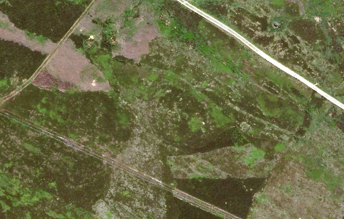
Aerial image, 2002Aerial image, 2009
The “length of banking” he described didn’t seem apparent when we visited the site yesterday (23.3.09), but we intend a further exploration of this and the adjacent monuments in the coming weeks and hope to locate it!
Interestingly, the archaeologists Faull & Moorhouse (1981:1:103), in their otherwise fine survey, actually doubted this place as having any prehistoric status, without giving any reason why—which was a big mistake. No doubt they spent too much time in offices and board meetings instead of getting out a bit more! Unless evidence to the contrary can be strongly presented, this site must be classed as undoubtedly prehistoric in nature (Bronze Age or Iron Age certainly) and almost certainly had something to do with rituals of the dead.
Great Skirtful Ring embankmentSouthern edge of the ring
From outer edge to outer edge the ‘ring’ measures 102 feet across, N-S, and with a rough maximum 101 feet E-W, being diameter, being some 300 feet in circumference. When you look at the site at ground level it appears to be an almost perfect ring, consisting of an embankment little more than 2 feet high at the most, with entrances both east and west. However, as the aerial images show, the perfect circle aint quite so perfect! But at ground level, there’s a certain uniformity about it. The embankment is in very good condition around much of the ring, with only slight damage in certain parts. The western opening strongly implies a direct relationship with the Great Skirtful cairn — which would infer this monument to have more of a ritual nature rather than the simple domestic enclosure, inferred by Colls and Cowling. Adding to this we find a tumulus 100 yards east and the remains of several other cairns nearby, making the site almost hemmed in by death-sites. A prehistoric cemetery is a short distance further down the moorland slopes to the east. Add also the fact that the Burley Moor stone avenue runs immediately south and the death-motif has to be increased.
What do I think it is? Not sure! The thought that it’s a previously unrecognized henge has crossed my mind…but henge monuments aren’t things that I’m very clued-up on, so wouldn’t like to say for sure. If there are any university archaeology students out there who are into getting their feet dirty, give this site a look-over. It’s intriguing, in very good condition, and could do with an accurate ID!
References:
Bennett, Paul, The Old Stones of Elmet, Capall Bann: Chieveley 2001.
Colls, J.N.M., ‘Letter upon some Early Remains Discovered in Yorkshire,’ in Archaeologia, volume 31, 1846.
Cowling, Eric T., Rombald’s Way, William Walker: Otley 1946.
Faull, M.L. & Moorhouse, S.A. (eds), West Yorkshire: An Archaeological Survey – volume 1, WYMCC: Wakefield 1981.


")
")