St. Pancras’ Well, Scampton, Lincolnshire

Holy Well (destroyed):  OS Grid reference – SK 9542 7853

Archaeology & History

Site shown on 1886 map

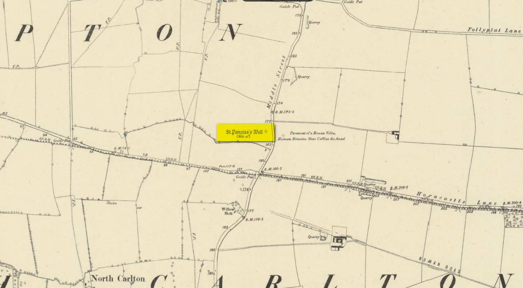
Mentioned in Thompson’s (1999) survey but without comment, it was, curiously, Skyring Walters’ (1928) that drew my attention to this site.  He added it to his list of St Pancras sites, telling how even in his day, it had fallen into memory.  Indeed, it had already gone when the Ordnance Survey lads came here in 1885.  Thankfully we were left with an albeit piecemeal account of the place by Cayley Illingworth (1810) before its destruction. It was an iron-bearing well that existed some fifty yards from an ancient Roman villa and was probably the water supply for the Romans who lived here.  He told us:

“The circumstance…of the chalybeate spring within a few yards from the entrance of the villa, and still called Saint Pancras Well…favours the conclusion of a chapel having been erected on its site.  (This) is supported by the strong evidence of a discovery, upon record, that a chapel dedicated to Saint Pancras did actually exist on this spot, so early as the beginning of the twelfth century; about which period Richard Fitz-Robert of Scampton gave to the monastery of Kirksted three selions of land in that lordship, two of which are described in the gift as lying in the south field, on the south side of the chapel of Saint Pancras.”

He further told that at the bottom of the well an oak floor had been laid, which had been dug up “several years ago.”

St Pancras’s festival date is April 3.

References:

  1. Cameron, Kenneth & Insley, John, The Place-Names of Lincolnshire – volume 7, English Place-Name Society: Nottingham 2010.
  2. Harte, Jeremy, English Holy Wells: A Sourcebook – volume 2, Heart of Albion Press: Loughborough 2008.
  3. Illingworth, Cayley, A Topographical Account of the Parish of Scampton in the County of Lincoln, T. Cadel & W. Davies: London 1810.
  4. Thompson, Ian, Lincolnshire Springs and Well, Bluestone: Scunthorpe 1999.
  5. Walters, R.C. S., The Ancient Wells, Springs and Holy Wells of Gloucestershire, St Stephens Press: Bristol 1928.

© Paul BennettThe Northern Antiquarian

Clach an Tuirc, Fearnan, Perthshire

Cup-Marked Stone:  OS Grid Reference – NN 72183 44970

Also known as:

  1. Boar Stone

Getting Here

Clach an Tuirc on 1862 map

Pretty easy to find unless the vegetation takes over!  From Fearnan take the road to Fortingall.  Just as you’re going out of Fearnan, in the walling by the very last house on the right-hand side of the road is this large earthfast boulder. Y’ can’t miss it!

Archaeology & History

I first visited the Clach an Tuirc – or the Boar’s Stone – in 1981 when I stayed at Fearnan for a few weeks and, after clambering on top, looked down on the several simple cupmarks.  Forty years later, I returned with a camera!

First highlighted on the 1862 OS-map, Fred Coles (1910) made a brief note of the petroglyph in one of his megalithic surveys, but only noticed a single cup, saying:

“Near Cromraor, close to the cottage at Clash na Tuirc, stands the large boulder bearing that name, the Boar Stone. Its highest point is about six feet above the road, and bears one very distinct cup-mark.”

But there are several cup-markings on top of the stone, just as William Gillies (1938) described.

Folklore

Not far from here tradition tells of a legendary figure who is known today only as the Lady of Lawers (whom tradition asserts to have been a member of the Stewart family, from Appin, Argyll – they of the daemonic Red Book of Appin).  She made various prophecies, one of which said “that when Clach an Tuirc, the Boar’s Stone at Fearnan, would topple over, a strange heir would come to Balloch.” Though as the stone still aint toppled, we’re still waiting… (let’s just hope this doesn’t augur more of those selfish tories into our mountains who bring with them their mantras of “gerrof mah land”)

References:

  1. Coles, Fred, “Report on Stone Circles Surveyed in Perthshire (Aberfeldy District),” in Proceedings Society Antiquaries, Scotland, volume 44, 1910.
  2. Gillies, William A., In Famed Breadalbane, Munro Press: Perth 1938.
  3. MacMillan, Hugh, ‘Notice of Two Boulders having Rain-Filled Cavities on the Shores of Loch Tay, Formerly Associated with the Cure of Disease,’ in PSAS 18, 1884. ???
  4. Yellowlees, Walter, Cupmarked Stones in Strathtay, Scotland Magazine: Edinburgh 2004.

Links:

  1. Canmore notes on Clach an Tuirc

Acknowledgements:  Huge thanks for use of the 1st edition OS-map in this site profile, Reproduced with the kind permission of the National Library of Scotland.

© Paul BennettThe Northern Antiquarian 

Chalybeate Well, Blockley, Gloucestershire

Healing Well (destroyed):  OS Grid Reference – SP 166 350

Archaeology & History

This is one of several iron-bearing wells (chalybeates) that used exist in and around the village.  Mentioned briefly in Alfred Soden’s (1875) history of the parish, he told that,

“years ago, there were several chalybeate springs here, very strongly impregnated.  One of these was at the lower end of Westmacott’s Lane: of this spring there is now no visible trace, it having been built over.”

Although Mr Soden said nothing about the healing properties of this well, due to the mineral composition of chalybeates they always tend to be good fortifiers or pick-me-ups, being good for the blood.  And in this case, as the waters were “very strongly impregnated” they would have possessed some considerable local renown.

References:

  1. Soden, Alfred J., The History of Blockley, J.W. Parbury: Coventry 1875.

© Paul BennettThe Northern Antiquarian

Blind Well, Blockley, Gloucestershire

Healing Well (destroyed):  OS Grid Reference – SP 163 347

Archaeology & History

It would seem that there’s no longer any trace of a healing well of some renown that once existed on the south side of Blockley village.  It is mentioned briefly in Alfred Soden’s (1875) history of the parish, where he wrote:

“At the back of what is called “Bath Orchard,” now belonging to Mr. John Herbert, there was a well called “Blind Well;” the medicinal properties of the water being considered to be remedial in cases of weak eyesight.  The writer has been informed that persons would come from a considerable distance to fetch water from this well for the purpose of bathing the eyes.”

References:

  1. Soden, Alfred J., The History of Blockley, J.W. Parbury: Coventry 1875.

© Paul BennettThe Northern Antiquarian

Rob Roy’s Well, Aberfoyle, Perthshire

Healing Well:  OS Grid Reference –  NN 43172 04274

Archaeology & History

Site shown on 1866 map

This long-forgotten site was found just by the old roadside several miles northwest of Aberfoyle, up the B829 Loch Chon road.  Shown on the first Ordnance Survey map of the area in 1866, subsequent visits showed no remains of it and we must assume it had fallen back to Earth.  When we visited the place recently, although there were no remains of any water trough, the spot where the well was shown on the map was very boggy with a small trickle of water running out of the slope.  There is the possibility that, if the soaked soil just above the trickling water was excavated a few feet into the ground, that the original spring might be retrievable.

Obviously, its name tells of the tradition that this was a place where Rob Roy was known to drink.  A number of places in this area bear his name.  Surely this is a site that is worthy of bringing back to life, so to speak, and place it on the Scottish heritage map, where it belongs?

Acknowledgements:  Huge thanks for use of the 1st edition OS-map in this site profile, Reproduced with the kind permission of the National Library of Scotland

© Paul BennettThe Northern Antiquarian

Wood Well, Batley, West Yorkshire

Healing Well:  OS Grid Reference – SE 2369 2422

Archaeology & History

Wood Well on 1854 map

In days of olde, before folk had taps to turn to get water, they’d have to go to the nearby wells and streams.  Many of these places were never written about, even to the point where no place-names were recorded, simply because the writers and surveyors either didn’t talk to the right people, or the right people didn’t talk to the surveyors!  In many cases, the latter is all too true.  Such is the case with this long forgotten healing well, whose memory is only preserved through the pen of a local man who, in the 19th century, was fortunate to have been able to write…

We know that old wells were mainly the province of women in most cultures through history; and Isaac Binns (1882) intimated this in his brief notes about the Wood Well.  There’s nowt much to tell to be honest, but its location and lore need to be preserved.

Lamenting the loss of trees, Mr Binns told of the Wood Well’s proximity to Carper Wood: shown on the first OS-maps, but long since destroyed by the ignorance of modernity.  In his day, the water from here was fresh “clear water.”  This alone was good, but something extra in the water gave it that added healing ingredient.  It was used medicinally,

“good yet, the old women say, for sore eyes.”

But not long after he wrote those very words, the Wood Well was destroyed…

References:

  1. Binns, Isaac, From Village to Town: Random Reminiscences of Batley, F.H. Purchas: Batley 1882.

© Paul BennettThe Northern Antiquarian

Sore Eye Well, Eldwick, West Yorkshire

Healing Well (destroyed):  OS Grid Reference – SE 1286 4007

Also Known as:

  1. Loadpit Well

Archaeology & History

Sore Eye Well on 1852 map

Descriptions of this site are few and far between, despite it having a meaningful name.  First recorded on the 1852 OS-map, in the folklore of our ancestors this was a well that local people frequented to wash their face and it was said that the waters would take away the ills of those suffering poor eyesight or other ocular problems.  Rags were left hanging over an old rowan tree as offerings to the spirit of the water, in return for curing the afflicted eyes.

When I first came looking for this as a boy, I was frustrated to encounter the water authority’s metal cover ruining the site completely, leaving nothing of the old well as it once was.  Around the metal-cover was evidence of a small rock enclave that would have defined the spring as it emerged from the earth—although it was barely noticeable.  The remnants of a small path just to the right of the main footpath that reaches up the hillside is apparent, leading to the well.  Below it were the remains of a large, water-worn flat rock, with other stones set to its sides, where the water used to flow and be collected, but today everything’s dried up and there’s little evidence of it ever being here.

References:

  1. Shepherd, V., Historic Wells in and Around Bradford, Heart of Albion: Wymeswold 1994.

© Paul BennettThe Northern Antiquarian

Bride’s Well, Ballintemple, Wicklow

Holy Well:  OS Grid Reference – T 17340 77380

Archaeology & History

The earliest OS-map of this area shows this well a hundred yards or so northwest of an old church and just a few yards east of the stream that is now in woodland; but unlike today, when the early survey was done there were no trees, enabling a clear view of the waters.  When Myles Ronan (1927) wrote of the place, he told that it was still visible.  The site was added to the Grogan & Kilfeather (1997) county inventory where they suggested it’s probable relationship with the legendary St Brigid.  This seems highly probable.  Does anyone know if the Well is still there?

References:

  1. Grogan, Eion & Kilfeather, Annaba, Archaeological Inventory of County Wicklow, Stationery Office: Dublin 1997.
  2. Ronan, Myles V., “The Ancient Churches of the Deanery of Arklow”, in Journal Royal Society Antiquaries, Ireland, December 1927.

© Paul BennettThe Northern Antiquarian

St. Philip’s Well, Keyingham, East Yorkshire

Holy Well (destroyed):  OS Grid Reference – TA 23584 25549

Archaeology & History

The Well shown on the 1855 6″ OS map

This holy well was formerly on the northern boundary of a field adjoining the north side of the A1033 west of Keyingham.

In view of the surviving folklore relating to the well it seems that its dedication to St. Philip may have been an effort by the Church to ‘Christianise’ it; and the St Philip here is not the Biblical Apostle, but a local saint – Philip Ingleberd (died c.1325 and also known as Philip Inglebred), whose memory was celebrated by a nearby Cross and a shrine at St Nicholas Church in the village.  The well and the cross may have been dedicated some time after 1392 following a ‘miracle’ relating to Philip’s tomb.  These were destroyed by the mob in the Reformation, although the cross-base survives.  It seems the well may have been restored in the late seventeenth century.  By the early twentieth century the well was described as laying on the Common to the west of the village, by then filled in, only showing signs it ever existed by making the ground near its site wet and boggy in a rainy season.

Folklore

George Poulson writing in 1841 told that,

“…a few fields more to the west is a well, called St. Philip’s Well; on a small stone are inscribed W. H. W. D. IG67. W. K.  It is called the wishing well; and the country lasses were in the habit of dropping pins, or even a sixpence into it, for the purpose of ensuring to themselves either particular or general good luck.”

William Smith (1923) described the well as one of six wishing wells or pin wells in Yorkshire and, moreover, the only ‘Cross Well’ in the East Riding.  At none of these wells was evil allowed to be foreshadowed, and the wells were only to show to a girl the portrait of her future husband.  He told us that,

“In every case the wish had to be with truthful devotion, and not divulged to any living person, or the desired consummation would not be gained…. Tradition adds that the well was much visited by maidens, who, on dropping their pins or coins, expressed the wish to see their lovers mirrored on its waters. Thus they kept a custom, dating to the time when the well was counted to be under the control of the fairies.”

And as Keyingham Common was once the abode of the fairies, it is worth noting that some 700 yards west of the site of the well a ‘Pans Hill’ is shown on the old maps, although whether this rural spirit of classical myth ever made it up to the East Riding is altogether another matter….

References:

  1. Arrowsmith, Nancy & Moorse, George, A Field Guide to the Little People, Macmillan: London 1977.
  2. Hope, Robert, Legendary Lore of the Holy Wells of England, Elliot Stock: London 1893.
  3. Poulson, George, History and Antiquities of the Seigniory of Holderness, Thomas Topping: Hull 1841.
  4. Smith, Rev. William, Ancient Springs & Streams of the East Riding of Yorkshire, A.Brown: Hull 1923.

© Paul T Hornby 2021

Pipers Stones, Blessington, County Wicklow

Stone Circle (destroyed):  OS Grid Reference – N 96998 14582

Archaeology & History

This stone circle was found close to the roadside and is remembered today only by the street-name of ‘Pipers Stones’.  Shown on the first OS-map of the area, the site was destroyed sometime before 1838.

Folklore

In a folklore motif found at a number of megalithic rings, Grogan & Kilfeather (1997) tell us that the name of this circle,

“refers to a tradition that people caught dancing on a Sunday were turned to stone.”

References:

  1. Grogan, Eion & Kilfeather, Annaba, Archaeological Inventory of County Wicklow, Stationery Office: Dublin 1997.
  2. o’ Flanagan, Michael, Letters Containing Information Relative to the Antiquities of the County of Wicklow, Bray 1928.

© Paul BennettThe Northern Antiquarian