This spring of water is in the edge of Nun’s Wood on the north side of the Dolphin Pond pool and is covered by a small stone building, from which issues a small stream into the lake. Remains of an old nunnery in the woods are said to be the oldest such monastic remains in England.
Folklore
This holy well, the woods in which it’s found, and the old straight road leading to the chapel,* are all said to be haunted by the headless ghost of old St. Osyth, beheaded — in one legend — by the Danes who came here in the 7th century. At the spot where she’s said to have received her final fatal blow, the waters from this now bricked-up old well gushed forth from the Earth. (Prior to this, folklore tells how St. Osyth was ‘killed’ several times, and each time came back to life – just as in shamanic lore, from which such early christian tales were glossed onto.)
Of it medicinal virtues, Robert Charles Hope (1893) told us that St. Osyth’s Well had been blessed by many a sufferer who found there a medicine for his ills, and at that time, “continues to this day as a sovereign remedy for many diseases.”
References:
Hope, R.C., Legendary Lore of the Holy Wells of England, Elliott Stock: London 1893.
* I’m presuming that the old road to the chapel here is the long straight grove of trees which ran from St. Osyth’s Chapel and up towards the well. Anyone know for sure?
This legendary-sounding spring of water was described in field-name listings from the 1770 Enclosure Acts, but nothing seems to have been written about it since. To me at least, there seems little doubt that this site would have been a sacred or legendary water-site. Curiously it is in William Henderson’s collection of northern folk-tales where we find a mention of further dragon lore from the township, albeit briefly, where he wrote:
“Near Chipping Norton, in Oxfordshire, A.D. 1349, was a serpent with two heads, faces like women, and great wings after the manner of a bat.”
In Nigel Pennick’s (1997) overview of dragon legends he copied Henderson’s earlier note, but neither of them gave specific indications relating the legend with our Serpent’s Well. So, to those of you who live in and around Chipping Norton (where I spent two very good years living with Sir Wilson at the Rollright Stones) – what has become of it? Where exactly is it? And does anyone know anything more behind this tale and any further history behind the ‘Serpent’s Well’?
References:
Gelling, Margaret, The Place-Names of Oxfordshire, Cambridge University Press 1953-54.
Henderson, William, Notes on the Folk-lore of the Northern Counties of England and the Borders, Folklore Society: London 1879.
Pennick, Nigel, Dragons of the West, Capall Bann: Chieveley 1997.
We were up here again in July 2009, but I’ve still not been across onto the island itself — just stared from the lochside, dying to swim across and spend a night or three alone on the island amidst this legendary landscape. Basically, get to Talladale on the A832 (halfway between Gairloch and Kinlochewe), then walk up to the loch-side to your right (east) for a mile till you reach the small wooded outcrop. Look north, betwixt the two isles and its the one in the middle with the Crag of the Bull and Maire’s Cairn rising up the mountain face behind. But you can reach it via a boat trip from one of the local harbours. Staying there overnight however, would seem more troublesome. It seems that a winter visit seems best!
Folklore
This ‘holy well’ has a prodigious occult history which, sez my nose, is still maintained by one or two old Highland folk up here. This small island (one of many in this long loch) was the Isle of the Druids in old days: legend telling it to be the teaching ground of these shady priests. Even the Iona druids came here. The main relics on on the island are the old holy well, accompanied by an old legendary tree into which all local people flocked and wedged coins at least once in their life. This devotional rite eventually took its toll, with so many of the coins covering the old tree with metallic scales to a height of nine feet, eventually killing it.
The well itself was said to cure insanity — no doubt the remedial quality given to the waters after neophyte druids had spent many days of ritual solitude here, eventually sipping its life-giving fluid to revive them from their ordeal.
It eventually became sanctified by the Church: legend saying it was St. Maelrubha (the same dood who turned the healthy Applecross heathens into church-goers) who was the guilty party. Indeed, the name Maree itself, was proclaimed as deriving from this old saint, though local lore tells it to derive from the pagan ‘ane god Mourie.’
Elizabeth Sutherland (1985) reported that remains of the sacred tree were still visible. It is also said that no-one makes ritual commemmoration here anymore. Hmmmm… don’t always believe what you read.
In the 18th century, when Thomas Pennant visited this sacred well, he described that,
“in the midst is a circular dike of stones… I expect the dike to have originally been druidical, and that the ancient superstition of paganism had been taken up by the saint (Maelrubha) as the readiest method of making a conquest over the minds of the inhabitants.”
References:
Dixon, John, Gairloch in North-west Ross-Shire, Co-op: Edinburgh 1886.
MacKenzie, Kenneth C., Loch Maree: The Jewel in the Crown, privately printed 2002.
MacKinlay, James M., Folklore of Scottish Lochs and Springs, William Hodge: Glasgow 1893.
Pennant, Thomas, A Tour in Scotland and Voyage to the Hebrides, MDCCLXXII, John Monk: Chester 1774.
Polson, Alexander, Gairloch, George Souter: Dingwall 1920.
Sutherland, Elizabeth, Ravens and Black Rain, Constable: London 1985.
Watson, W.J., Place-Names of Ross and Cromarty, Northern Counties Printing: Inverness 1904.
* This beautiful painting is one of many done by local artist, Bryan Islip. It is taken from his 2010 Calendar, Scotland’s Wester Ross, and is available direct from him. If you’d like to know more, or want copies of his calendar or other artworks, email him at: pico555@btopenworld.com – or check his website at www.picturesandpoems.co.uk
Take the A658 road north out of Bradford, past Undercliffe, and downhill towards Greengates. When you meet with the large junction where Ravenscliffe Avenue turns to your right – stop! Immediately on the left-hand side of the road is where the old well used to appear.
Archaeology & History
Old map showing Eccleshill’s Holy Well
In times past this was one of the most renowned holy wells in the region (we have at least 200 in West Yorkshire). First recorded as a holy well in 1585, specialist writer Edna Whelan remembers the waters here running into a stone trough at the side of Harrogate Road when she was young.
In 1932, local historian W.E. Preston described, “the remains of what was once a fine grove of trees leading up the hillside from the road to its source,” implying ritual commemoration and a procession to the site. Today, this grove is still evidenced by the straight footpath across the main road, leading to the infamous Ravenscliffe estate.
In 1704 a court case was brought against some locals – Mr & Mrs Richard and Sarah White (and their daughter, Mary) – “for diverting the water from its ancient channel.”
In 1867 it was described in the Object Name Book:
“A considerable and well-known spring, it has the appearance of having been a bathing place. A bank has been thrown up on the east side, and a broken wall remains on the other sides. There is no tradition about it. It is likely to have been of some note…in the days of Romanism. Large trees are ranged on either side of the approach to it, forming a grove.”
Up till 1978, Andrea Smith (n.d.) reported the well to still be “protected by local tradition,” but this is no longer possible. Yorkshire Water don’t particularly give a damn about its preservation (water is money folks!) and today it’s covered by a man-hole in the garden.
References:
Preston, William E., ‘Notes on the Early History of the Manor of Eccleshill,’ in Bradford Antiquary, 5, 1912.
Preston, William E., ‘Some Local Holy Wells,’ in Bradford Antiquary, June 1932.
Smith, Andrea, ‘Holy Wells Around Leeds, Bradford & Pontefract,’ in Wakefield Historical Journal 9, 1982.
Whelan, Edna & Taylor, Ian, Yorkshire Holy Wells and Sacred Springs, Northern Lights: Pocklington 1989.
In Roeder & Graves’ (1906) analysis of the neolithic remains surrounding this geological arena, they told there to have been “at least nine wells at different parts of the Edge” — this and the Wizard Well being the ones of greater local renown. Flints and the remains of neolithic man were found all round here. Obviously the water from this well here would have been of primal use.
Folklore
In 1843, Robert Bakewell told how the waters from this famed well, “are said to be a cure for barrenness.” As well as this he reported how a large boulder fell from the Holy Well Rocks above it around 1740, and “a woman and a cow are said to have been buried under it.” But a lengthier description came from Roeder & Graves’ archaeological essay, where they told how both the Wizard Well and this site, “were in ancient times connected with well worship.” They continued:
“Their healing powers were considered to be unfailing: the barren, the blind, the lame, and bodily-afflicted constantly made their way thither; maidens whispered their vows and prayers over them, their lovers and their future lives being their theme. Crooked silver coins were dropped into the well, but these have been cleared out long ago. At present time the devotees are satisfied, in their economical habit, to offer mere pins and hairpins; the custom is not yet dead, for some of the immersed pins are still quite corroded and bright. Some of the sex deposit the pins in their straight and original form, others bend them only at right angle, and as many again seem to consider the charm alone to act effectively when carefully and conscientiously doubled-up. Maidens of a more superficial cast just the slightest twist to the object. To judge from the state of corrosion and the old-fashioned, thick globular heads, some of these pins must have been in the well for at least sixty years… There are occasionally to be seen also a few white pebbles in the two wells.”
References:
Bakewell, Robert, Alderley Edge and its Neighbourhood, J. Swinnerton: Macclesfield 1843.
Roeder, C. & Graves, F.S., ‘Recent Archaeological Discoveries at Alderley Edge,’ in Trans. Lancs & Cheshire Antiq. Soc., 1906.
This famous old site can be found right by the roadside—the B6480—as you head out of the northern end of the town, beneath Giggleswick Scar. It’s less than a mile along the old main road, just as you start to climb up the hill, just across from the entrance to Huntworth. It is in reasonable condition and has long been thought of as a holy and magickal well. Edna Whelan and Ian Taylor included it their fine work, Yorkshire Holy Wells. (1989)
Archaeology & History
The site as we see it today is but a shadow its former self. Although the stone trough that we look at seems to be the site, this once great great well originally emerged up from the ground a good hundred yards further up the steep hill slope above us, as the early illustration here clearly shows.
Ebbing & Flowing Well (Whitaker, 1878)
Just above where the Ebbing & Flowing Well first appeared an excessive amount of flints were found in earlier years; and just above that, early human habitation in the caves to the back; along with ancient burials nearby — as well as numerous other neolithic, Bronze- And Iron Age remains all round here. This peculiar water supply was obviously of considerable importance to our pre-christian ancestors…unless you’re an idiot that is!
The site’s name comes from the very action of the waters here, which have sadly long-since been stopped. The well could suddenly overflow very rapidly and the next minute subside, with seemingly little rational explanation. As such, it was seen to be miraculous. It was first described by one John Speed in 1627 (England and Wales Described), where he said,
“At Giggleswicke…there are certain small springs not distant a quaits cast from one another; the middlemost of which doth at every quarter of an houre (?) ebbe and flowe about the height of a quarter of a yard when it is highest, and at the ebbe falleth so lowe that it be not an inch deepe with water.”
Ebbing & Flowing Well
Though Harry Speight (1900) reckons such rapid undulations were slight exaggerations on Speed’s part.
Nearby we also find the Bank Well, where old lead goddess figurines were deposited around Romano-British times. Archaeologist Alan King (1970) saw such deposits as important to the spirit of the waters, saying,
“The wells at Giggleswick, especially the Ebbing and Flowing Well, would be considered entrances to the Underworld and suitable sites for making offerings.”
It seems more likely however, that the Ebbing and Flowing Well would have a more pronounced oracular nature; though Underworld aspects would be prevelant, though would be the province of selected priestesses (whose folklore is found nearby, albeit in distorted form).
The waters themselves today flow quite well, but are close to freezing when you immerse your hands therein. They also taste very good indeed and are most refreshing – better than any of the alleged ‘spring water’ people today buy in plastic bottles. It’s gorgeous water here!
Folklore
Early drawing of the Well
An undoubted oracular site: the ebbing and flowing actions of the waters giving the well the distinct characteristic as a place used for prophecy and divination in very ancient times. I have little doubt that this was a place used by shamans. It was likely to have been a dreaming site aswell. (it would be good to know if there is any old witchcraft lore still left here)
The waters themselves are supposed to be a manifestation of a local female spirit, who was transformed into the waters by a woodland spirit. Also here, a local highwayman called Nevison was being chased by the local cops, when his horse stopped at the waters desparate for a drink. While here, Nevison prayed to the water spirit for help. She duly obliged, giving him a magic bridle, enabling his horse to run and jump over the high moors to escape his pursuers: a place called Hell Ghyll being one of the places he was said to have cleared.
References:
Bord, Janet & Colin, Sacred Waters, Granada: London 1985.
Hope, Robert Charles, The Legendary Lore of the Holy Wells of England, Elliott Stock: London 1893.
King, Alan, Early Pennine Settlement, Dalesman: Clapham 1970.
Ross, Anne, Pagan Celtic Britain, RKP: London 1967.
Speight, Harry, The Craven and NorthwestYorkshireHighlands, Elliott Stock: London 1892.
Whelan, Edna, The Magic and Mystery of Holy Wells, Capall Bann: Chieveley 2001.
Whelan, Edna & Taylor, Ian, Yorkshire’s Holy Wells and Springs, Northern Lights: Pocklington 1989.
Whitaker, T.D., The History and Antiquities of the Deanery of Craven, Joseph Dodgson: Leeds 1878.
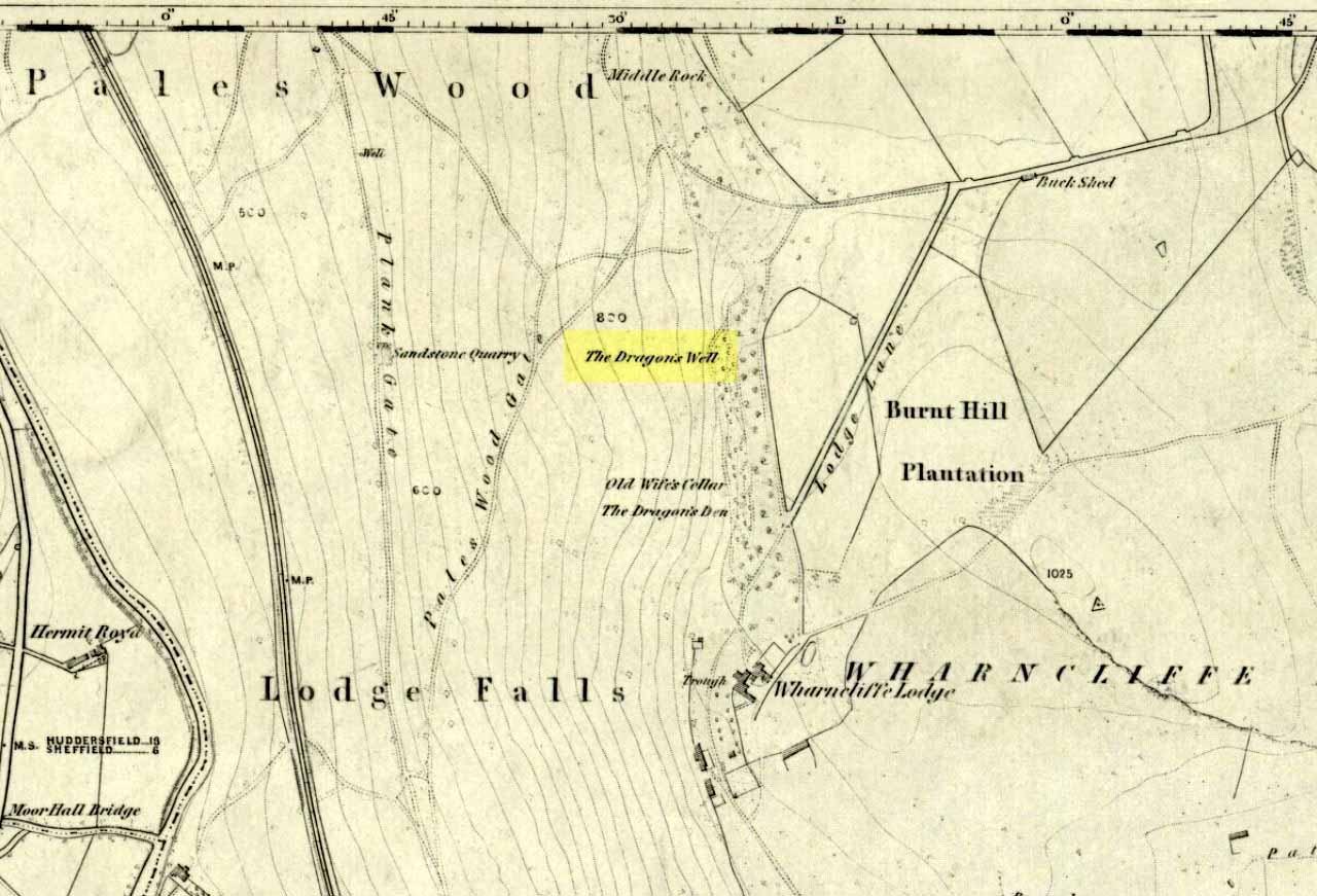
Highlighted on the first OS-map of the area in 1855—along with it’s home and an associated site of the Cailleach, or Old Wife’s Cellar close by—the famous Wharncliffe Dragon used to drink from here, moreso than the other Dragon’s Well at Bolsterstone more than a mile to the west. The dragon – with its “seven heads and twice seven eyes” – lived a short distant away on the rocks above, at the Dragon’s Den. The description of this great beast and its antics at the well were summed-up in Rob Wilson’s book on the Holy Wells of South Yorkshire (1991). He told that:
“The Wharncliffe area has been taken as the setting for the theme of a centuries-old ballad of 19 stanzas , its full title being, ‘An Excellent Ballad of a Dreadful Combat fought between Moore of Moore-Hall and the Dragon of Wantley.’ The 6th and 13th stanzas contain references to Dragon’s Well and are printed below in full:
“Some say this dragon was a witch;
Some say he was a devil;
For from his nose a smoke arose,
And with it burning snivel;
Which he cast off when he did cough,
Into a well that stands by;
Which made it look just like a brook
Running with burning brandy.
It is not strength that always wins,
For wit doth strength excel;
Which made our cuning champion
Creep down into a well:
Where he did think this dragon would drink,
And so he did in truth;
And as he stopp’d low, he rose and cry’d Boh!
And he hit him on the mouth!””
References:
Jewitt, Llewellyn, ‘The Dragon of Wantley and the Family of Moore,’ in The Reliquary, April 1878.
Wilson, Rob, Holy Wells and Spas of South Yorkshire, Northern Arts: Sheffield 1991.
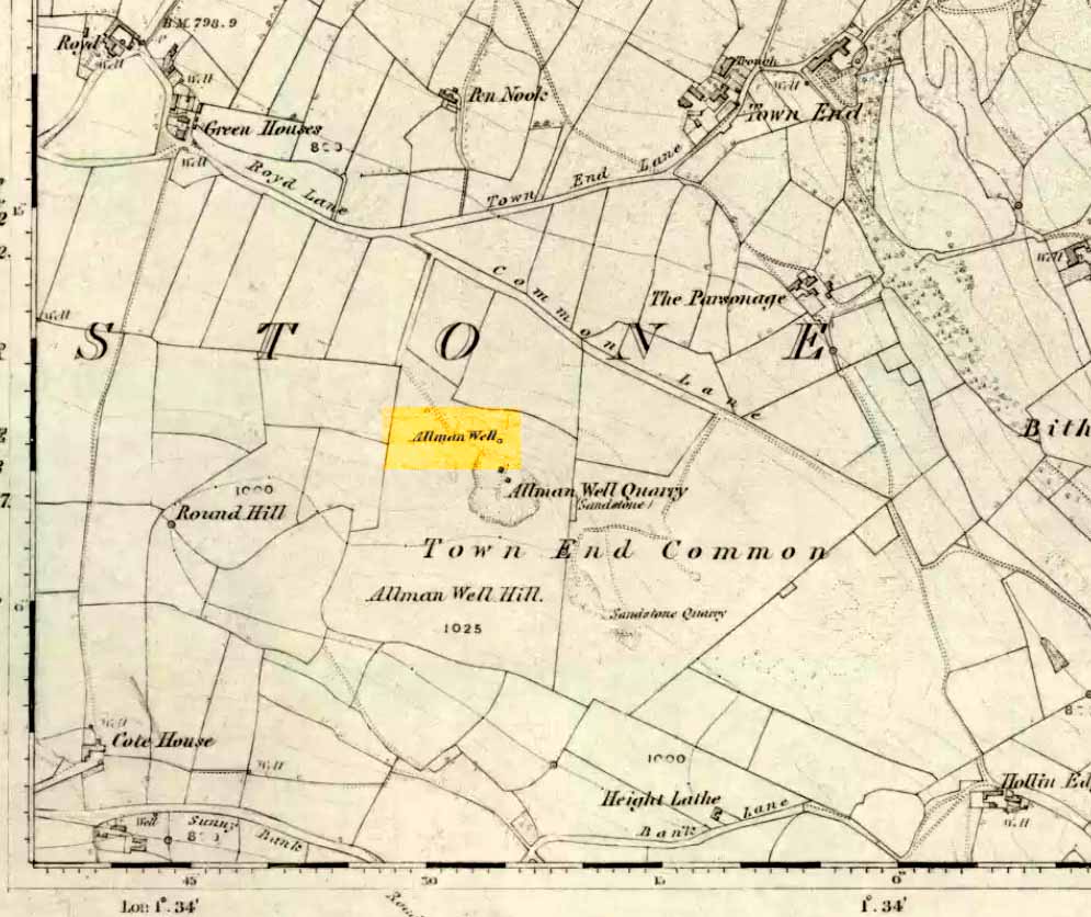
Also known as the Allman’s Well, an inscription with an 1818 datestone was to be found here. But according to folklorists Dave Clarke & Phil Reeder, the site can no longer be found as its waters were “diverted for use at a nearby farm.” However, something that does need checking is their description of a cup-and-ring stone on one of the boulders close by – reckoned to be one of those dropped by the dragon which gives the well its name.
Folklore
Something strange was once going on in this locality if place-names and legends have owt to go by. The local Wharncliffe Dragon, as it was known, used to fly from its home at the Dragon’s Den (a mile-and-a-half east of here) and drink the waters from this well. On one of its flights from Wharncliffe Crags, it carried with it three huge boulders which it dropped in transit and which were said by the folklorists David Clarke and Phil Reeder “to stand in a line on the slope below the well at Townend Common.”
The water from here was said to be good for curing both asthma and bronchitis and was also said never to have dried up, even in the greatest of droughts.
References:
Wilson, Rob, Holy Wells and Spas of South Yorkshire, Northern Arts: Sheffield 1991.
Paul, Danny and I came here via the Feizor village route, zigzagging about, to and fro, seeing the other old sites in the region; but the easier direct way to get here would be from Settle. Walking through Settle, going out of the top end of town, cross the old bridge and take the country-lane on the right, up northwards towards Stackhouse. A mile along the road (shortly before Stackhouse), a footpath on your left veers up diagonally through a small copse of woods. Go up here and out the other side of the trees, the path turns left and up over the fields. Go up here, and over the third wall along the footpath, you’ll see a large overgrown pile of rocks 30 yards in front of you with a large stone laid roughly in its middle. You’re here!
Archaeology & History
This is an excellent though much neglected prehistoric cairn of some considerable proportions, its rocky mass laying half-covered in deep earth and grasses, yet with still a very large section of it open to the elements. The creature is nearly 30 yards across and some 4 yards high — though it’s hard to say with any certainty, where exactly the natural Earth begins and the cairn starts. But from whichever way you look at this large cairn, walking around the overgrown features, you know it’s a big thing — similar in size and nature to the Great Skirtful of Stones on Burley Moor, and the neolithic cairn on Bradley Moor, near Skipton.
Paul & Danny atop o’ t’ pileBear’s photo, looking SW
On the modern OS-map there are 2 ancient cairns marked close to each other — and our “Apronful of Stones” is the lower one of the two.
In recent years the site was described briefly in Dixon’s (1991) Journey through Brigantia, but there’s been very little written about the place in modern archaeological surveys. The first account I’ve found of the site was written by an anonymous “W.F.” in The Gentleman’s Magazine of 1784. In a detailed lengthy essay, the following words were penned:
“This barrow, or tumulus, stands in an elevated situation, upon a mountain, above the hamlet of Stackhouse, and may be discerned at a great distance…
“The form of this vast mass is circular, or rather orbicular ; the height, by computation on the spot, about 9 or 10 feet. It is composed of an incredible quantity of stones, piled in such a manner as to rest upon each other’s basis, and strengthened by its conic form, it rises upwards in this curious shape. Those stones that form the outside of the work are so small that a soldier could carry them; and since it has been argued that such a monstrous work as this would not be attempted by any nation, but was natural, the largeness of the tumulus may easily be accounted for, since they were annually increased out of reverence…
“This barrow had been opened many years ago, and it is represented in the plate in the state in which it has appeared till lately. Some old people in the neighbourhood remember its being entirely complete, and having a very flat top. It was usual, in finishing these works, to lay a flat stone at the top. The people that opened it left their intention unfinished, only throwing down the lid of the stone coffer, and one or two of the sides; and, meeting with nothing worth digging for, they left it. Upon examining it in this state, before its being entirely disfigured in the last attempt, I found several human bones scattered up and down therein, amongst which I selected the patelae of the knee, the vertebrae of the spine, part of the jaw, and several teeth.
“Round the area is a wall or rampart, of the same materials as the outside, its height from the interior part about 2 feet, irregularly ranged with fissured remnants. In the centre of the cavity or area is the above chest, consisting of several huge stones of vast magnitude and density, fixed firmly into the ground, which supported a lid of equal size, though it is now thrown off the top. In this chest are partitions, for what purpose is not known, unless each space was allotted to its particular relique or body. In the partitions and sides of the coffin is a kind of hole in the edge, with a rude mould. (my italics, PB) Not many weeks ago, the curiosity of some of the neighbourhood was excited to investigate this stupendous work of art, and accordingly labourers were hired, when, upon searching a day (yet not half the work done), a human skeleton was found, in due proportion, and in a fine state of preservation, excepting the skull and one of the limbs, which were moved out of their place by the workmen’s tools. A small circular piece of ivory, and the tusk of an unknown beast, supposed to be of the hog genus, was also found ; but no ashes, urns, coins, or instruments were discovered. ”
Many years later the giant cairn was described briefly in William Howson’s (1850) early survey of the district, when he told that,
“Near a gate on the path, where the descent is commenced to Stackhouse, there’s a cairn of eighty feet in diameter; it has not been completely examined, but human bones are commonly found in it.”
But it was more than a century after “W.F.’s” initial essay before another detailed appraisal of the place was given — and that was after a visit here by the legendary Harry Speight (1892) in the latter half of the 19th century. Along with mentioning a number of other prehistoric tombs upon this ridge, Mr Speight told:
“From Settle Bridge you may take the field-path…or the rustic lane to Stackhouse, and where the road divides just beyond Mr Priestley’s pretty house you wind beneath the wood behind Scale House to a gate and stile on the left. Here ascend the field between two large trees, and at the top go over a stile, whence a path leads up the field a good half-mile to a gate which opens into what our remote Celtic ancestors would have reverentially called the ‘Field of the Dead,’ for within this enclosure are traces and remains of human graves which carry us back to the far dim ages of unwritten history. Following the grassy cart-road a short distance you will see on the left a large circular mound thrown up about 30 feet on the south side, and about 10 feet on the north or higher side. There are other mounds of similar and smaller dimensions within the same area, some of which have been examined, but others do not appear to have been disturbed. Many of the barrows or ‘raises’, have at some time or other been carelessly dug into in the hope of finding valuables, and as doubtless in most cases nothing was found but rude chests or coffins, containing bones, these were tossed aside and no record of them deemed worthy of preservation…
“The largest of these existing raises has happily been described by a writer who signs himself ‘W.F.’ in the ‘Gentleman’s Magazine’ for 1784 and 1785. Although his account fills several pages, it is obviously defective in many particulars. We are told that the circumference of the base of the mound is 210 feet, and that its height is 9 or 10 yards, and that the casing is composed of stones “so small that a soldier could carry them,” while the inside is made up of earth and stones, some of the latter being “much larger than the external coating.” In form it was circular…and the diameter of the summit was 45 feet. The barrow he tells us was opened many years ago, but some old people in the neighbourhood remember it being entirely complete, and having a very flat top.
“…Upon examining it in its former state the writer discovered several human bones scattered about the rock and soil, among them the palletae of the knee, the vertebrae of the spine, part of the jaw and several teeth. In the centre of the mound was a cavity containing a chest composed of four upright stones and a lid 6 feet 9 inches long and 3 feet broad. The chest was in partitions, in the edges of which were a kind of hole with a rude mould. The writer, under date, Settle, Nov 23rd 1784, next informs us that, “not many weeks ago the curiosity of some of the neighbourhood was excited to investigate this stupendous work of art, and accordingly labourers were hired, when upon searching a day (yet not half the work done) a human skeleton was found, in due proportion, and in a fine state of preservation, excepting the skull and one of the limbs, which were moved out of their place by the workmen’s tools. A small circular piece of ivory, and the tusk of an unknown beast, supposed to be of the hog genus, were also found; but no ashes, urns, coins, or instruments were discovered.”
Other important prehistoric monuments can be found on the grassy limestone plain beyond the Apronful: these include the fascinating Sheep Scar Enclosure just 180 yards (165m) to the north; an associated prehistoric cairn (one of several) 57 yards further northeast; and a delightful, though overgrown cairn circle 325 yards NNW. Other Iron Age and Bronze Age remains can be found elsewhere within this arena. Archaeologists could do themselves a big favour by exploring this landscape more efficiently than they’ve done so far as other unrecognized sites exist in this area.
Folklore
Big stone in t’ middle
Harry Speight (1892) told us how the place got its name “from a tradition…that his Satanic Majesty, in haste to complete the bridge bearing his evil name near Kirkby Lonsdale, tripped and his apron-string broke which let drop this immense heap.”
Another tradition narrated again by our anonymous ‘W.F.’ in the Gentleman’s Magazine(1785) said how this giant tomb, “was raised over the body of some of the Danes slain in the general massacre of that nation.” He also told, “Such a conspicuous work must certainly be erected to the manes of some chiefs, though there is no ground to support its tradition.”
References:
Dixon, John & Phillip, Journeys through Brigantia – volume 4: Beyond the Hill of Winds – Walks in Upper Ribblesdale, the Three Peaks & Upper Wharfedale, Aussteiger: Barnoldswick 1991.
Ferrand, William, “Stackhouse, Yorkshire,” in The Gentleman’s Magazine (London 1784).
Howson, William, An Illustrated Guide to the Curiosities of Craven, Wildman: Settle 1850.
Speight, Harry, The Craven and Northwest Yorkshire Highlands, Elliott Stock: London 1892.
Many ways to get here, but the easiest for those with cars to is park up on the southeast edge of the hill, at the various scruffy parking bits beside the road at the Nick of Pendle. The view from here is enough to get you going! Walk onto the great hill up to the rounded pap of Apronfull Hill (rather gives it away really!). It’s only a few hundred yards up – about 10 mins up the slope from the road, with awesome views all round once you get there. Tis the small guidance cairn you’re looking at just on the level. You’re there!
Archaeology & History
This would once have been a rather huge cairn/tomb — though when I first found the remains of this place in August 2006, there were no archaeological records describing it that I could find. But there’s very little left of it. The lads who did the quarrying further downhill (where you’ve probably parked your car) are likely to have been the culprits who nicked most of the rocks that once made this huge forgotten tomb. But as you potter about here, it becomes obvious that you’re standing on the much-denuded remains of just such a monument (very similar in size and structure to the more famous Little Skirtful and Great Skirtful of Stones on Burley Moor, or Black Hill round cairn near Skipton). But the remains you can see beneath your feet still give a good idea as to how large it was.
Remnants of the cairn-spoil cover the ground where the monument once stood proud!
You’ll see once you’re stood here that there are hundreds, maybe even several thousands of stones just on and below the ground, scattering a very well-defined roughly circular area measuring at least 21 yards (east-west) by 22 yards (north-south), right by the side of the path. The edges of this ransacked cairn are pretty well defined around the north and eastern sides. Near the centre of the old structure is a very notable ‘dip’ in the ground where it looks as if something has been dug away — though this could just as well be due to the presence of underground water, as indicated by the growth of Juncus grasses. Without an excavation it’s obviously difficult to tell.
Folklore
Twas the following tale which first led my nose to explore this part of Pendle hill. It’s a tale we find at many of our upland tombs, though the record books said there was nowt here! (any myopic archaeologists out there who reckon that folklore has no relevance to their subject, educate one’s self!)
Looking from the Devil’s Apronful towards Jeppe Knave’s Grave
The Devil was having trouble with the folk at Clitheroe Castle (a few miles west) and wanted rid of it. So he picked up various large stones and put them in his apron then threw them towards the castle. Most of them missed, which made him angry and in a rage he accidentally dropped a great pile of rocks on the south side of Pendle Hill, creating the Devil’s Apronful on Apronfull Hill.
In another tale he was said to have stood at the Deer Stones a few hundred yards east of here and threw rocks from there. Perhaps a folk-remnant of where the Apronful stones once came from…? Perhaps not.
Jessica Lofthouse (1976) notes how this old spot was long known by local people as the Devil’s Apronful.
References:
Lofthouse, Jessica, North-Country Folklore, Hale: London 1976.