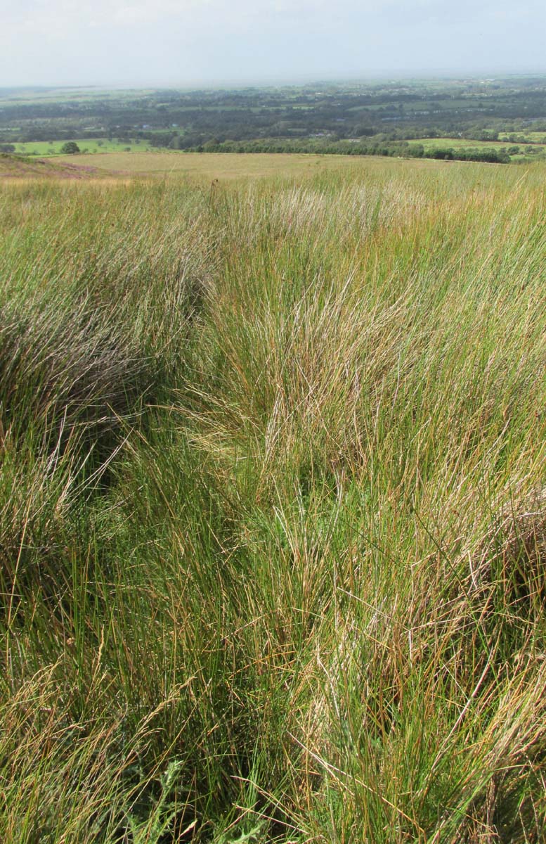
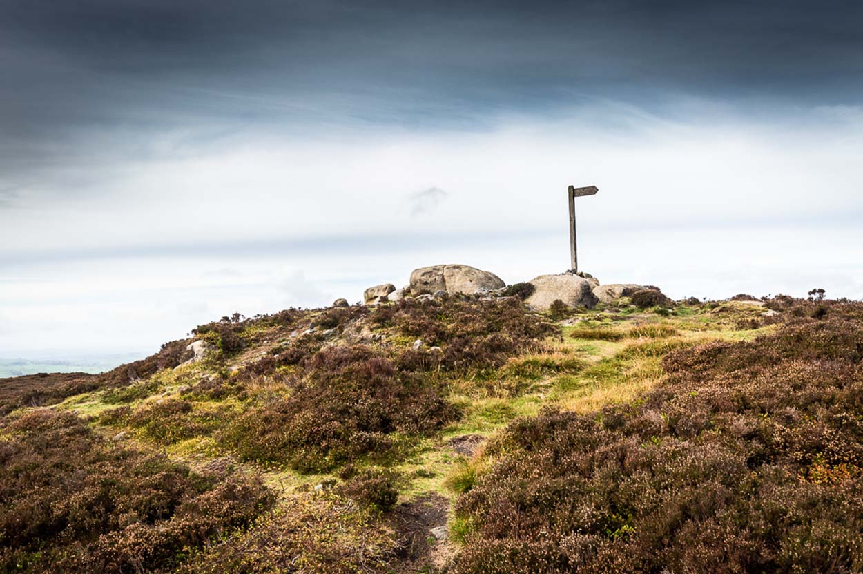
Approaching the site from the north, walk along the Lane Head track, and along the path south-eastwards, then turn right onto the main footpath until coming to the stream. Follow the stream up the fell to the large clump of reeds, then follow your ears until you locate the spring! Or you can approach it along the main footpath from the Oakenclough – Galgate road. The well and the path to it
are on access land.
Archaeology & History
Fortunately recorded by the Ordnance Survey on their 1846 6″ map Lancashire XL, the story of St Ellen’s Well was taken up sixty years later by local holy wells historian Henry Taylor (1906):
Listen for the spring in the reeds
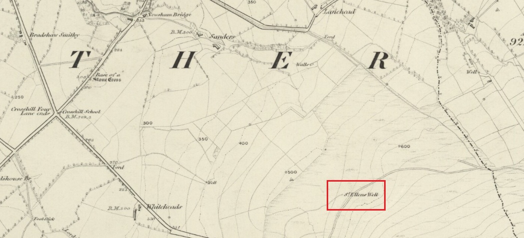
“The site of this holy well is marked on the ordnance map at a lonely spot on Harris Fell, five hundred feet above the sea-level, four and a half miles in a north-easterly direction from the town of Garstang.
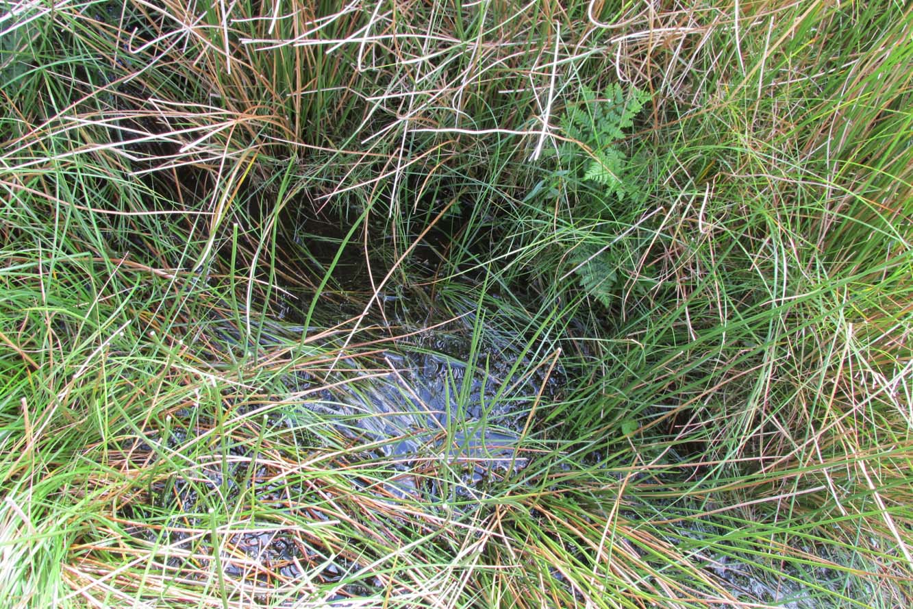
“Mr. A. King has kindly examined the site. He writes, 4th August, 1902: “We had no difficulty in locating the spot…. There is no outward indication of the place being used for curative means, and there is no stonework at all. It is a beautifully cold spring which is at the side of ‘Bonny Pad’, a pathway leading across the moor from Harris End, and it was grown around with rushes…. All I can glean about it is that one of the oldest inhabitants, when asked if he knew of it, replied, ‘It will be th’ holy well, you mean.'”
The original dedication of this remote holy well was clearly to St. Helen, and its presence next to the Bonny Pad or path may indicate a pre-Christian dedication to a local cognate of the Celtic Elen Luyddog, Elen of the hosts or ways. The Bonny Pad is shown but not not named on the 1846 map, and follows a broadly southwest to northeast direction from Harris End (again not named on the 1846 map) up to Grizedale Head on the southern edge of the Catshaw Vaccary. It was perhaps an ancient route used by farmers to take their animals up onto the fell for the summer, and return them to the lowlands in the autumn.
Bubbling away at source
The western portion of Bonny Pad is not shown on the modern map and St Ellen’s Well is not marked, and both have it seems passed out of local memory. An elderly farmer I encountered on my way up to the fell had never heard of the Well.
It is certainly worth the walk if only for the delightful sound of this powerfully flowing spring, the water is pure and cold, and it commands a fine view over the Lancashire plain to the coast.
References:
Taylor, Henry, The Ancient Crosses and Holy Wells of Lancashire, Sherratt & Hughes: Manchester 1906.
Wise, Caroline, “Elen of the Roads of Country and Town”, in Finding Elen – The Quest for Elen of the Ways, edited by Caroline Wise, Eala Press: London 2015.
Tumulus (destroyed): OS Grid Reference – TL 6122 6358
Archaeology & History
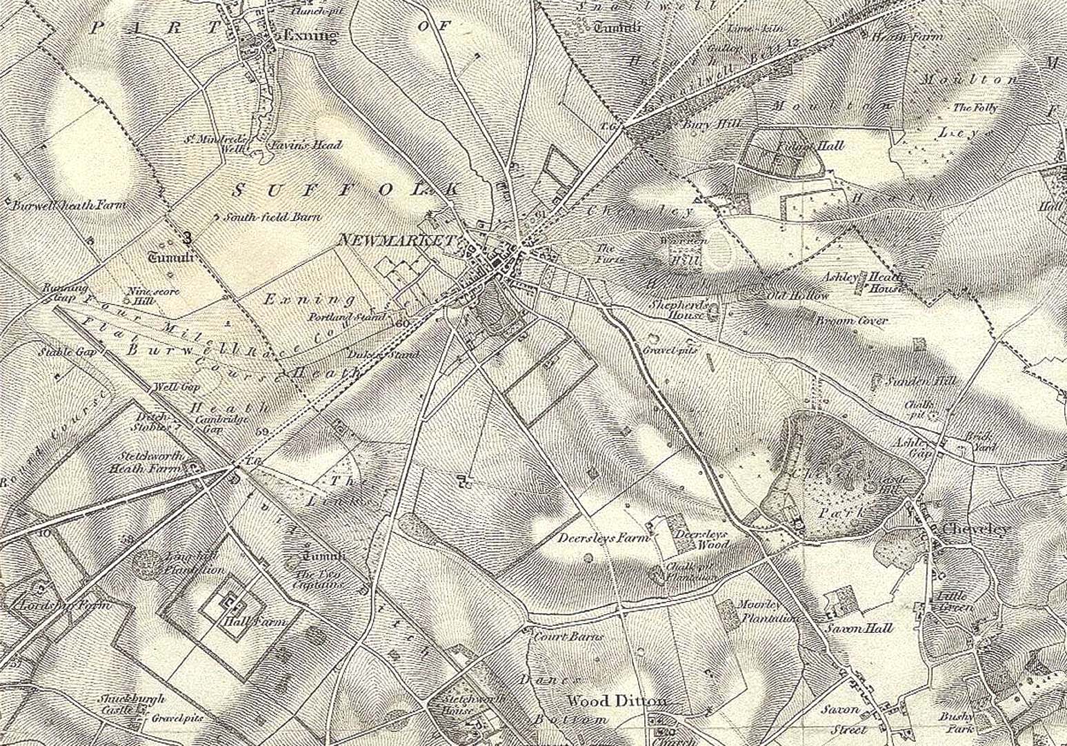
Tumulus ‘3’ on 1834 map
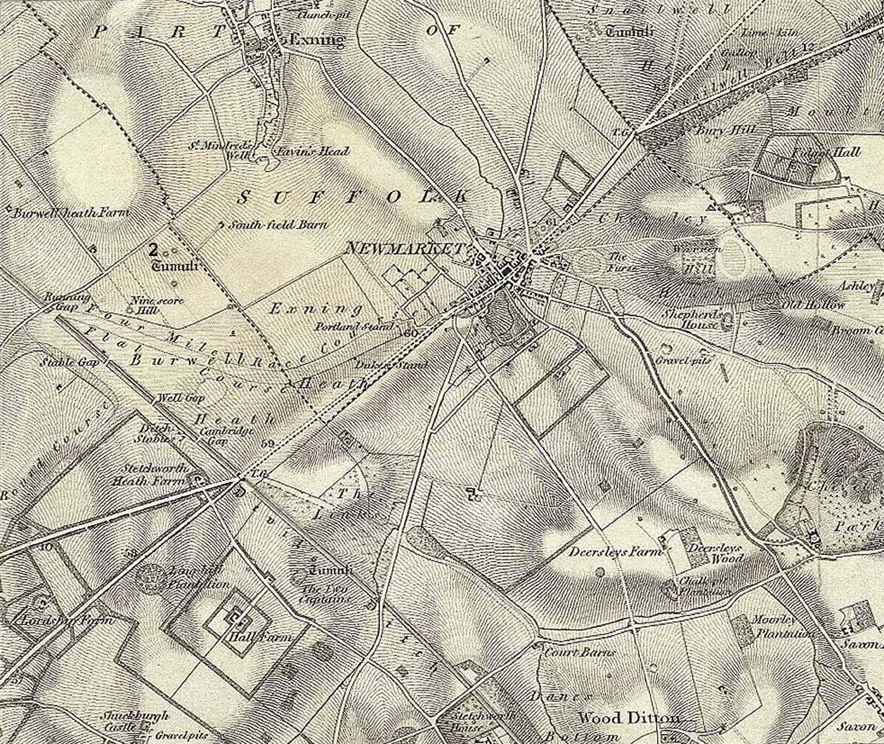
This is one of at least five prehistoric tombs that were known to have existed in and around the Newmarket race-course—all long gone. It stood some 50-60 yards northeast of the Newmarket Heath (2) tumulus and was one in the cluster highlighted as ‘tumuli’ on the 1834 OS-map (right). Despite its destruction sometime in 1883, a scar of the monument was seen from the air in the 1940s by J.K.S. St Joseph as a ploughed-out ring ditch, showing it to have been some seventy feet across. Sadly, no ground trace of the monument exists.
Royal Commission Ancient Historical Monuments, Inventory of Historical Monuments in the County of Cambridgeshire – Volume 2: North-East Cambridgeshire, HMSO: London 1972.
Tumulus (destroyed): OS Grid Reference – TL 6116 6352
Archaeology & History
Tumulus 2, centre-left
This is one of at least five prehistoric tombs that were known to have existed in and around the Newmarket race-course. Found some 600 yards NNE of the Ninescore Hill tumulus, and some 40 yards from its nearest companion, it was shown as one in a group of ‘Tumuli’ on the 1834 OS-map (right) but, along with the rest, was subsequently destroyed sometime around 1883. A landscape scar of the monument was seen from the air in the 1940s by J.K.S. St Joseph as a ploughed-out ring ditch some 75 feet across. This was reported as still visible by the Royal Commission doods in the 1970s, but no ground trace whatsoever exists.
Royal Commission Ancient Historical Monuments, Inventory of Historical Monuments in the County of Cambridgeshire – Volume 2: North-East Cambridgeshire, HMSO: London 1972.
This is one of many long lost prehistoric tombs that were known to have existed in and around the Newmarket race-course, but unlike the Newmarket tumuli 1 – 4 which were all on the first OS-map of the area, this one had been destroyed before the Ordnance Survey lads came here. As a result we don’t know its exact whereabouts.
Described in both the Cambridge Chronicle and Gentleman’s Magazine in 1827, the accounts even then were talking about it in the past tense, albeit pretty recently. The race-course at Newmarket was being modified, leading to the destruction of our ancient landscape—and with it, this tumulus. In those days however, such destruction was deemed as an ‘improvement’, as Sylvanus Urban (1827) tells at the start of his account:
“The improvements making in the exercise ground at Newmarket, Cambridgeshire, have led to some discoveries which may, perhaps, tend to the elucidation of the hitherto obscure origin of the entrenchment commonly called “The Devil’s Ditch.” In removing one of the monumental remains denominated barrows, or tumuli, which are numerous in this neighbourhood, the skeleton of a person was found deposited near the surface, whose remains were too recent to be associated with the area of its place of interment; but, upon clearing away the earth to the centre of the mound, a discovery was made of an urn, of rude construction and materials, containing ashes, together with some beads, which, it is presumed, formed the ornaments of the person to whose honour the barrow was dedicated. There were also found two coins, supposed to be Roman, and a fragment of a cup, of far superior manufacture to the urn, lying promiscuously at the depth of about two feet.”
A summary of this was included in Babbington’s (1883) archaeological survey. But in Cyril Fox’s (1932) list of barrows near Cambridge he seemed to confuse this “tumulus on Exercise Ground” (no.16) with what he thought was another tumulus (no.17), which he described as, “Exact site unknown. Contained a cremation interment. Burnt bones and sherds of Bronze Age type, also Roman sherds.” The two are the same thing.
Royal Commission Ancient Historical Monuments, Inventory of Historical Monuments in the County of Cambridgeshire – Volume 2: North-East Cambridgeshire, HMSO: London 1972.
Urban, Sylvanus, “Domestic Occurrences,” in Gentleman’s Magazine, September 1827.
Tumulus (destroyed): OS Grid Reference – TL 613 633
Archaeology & History
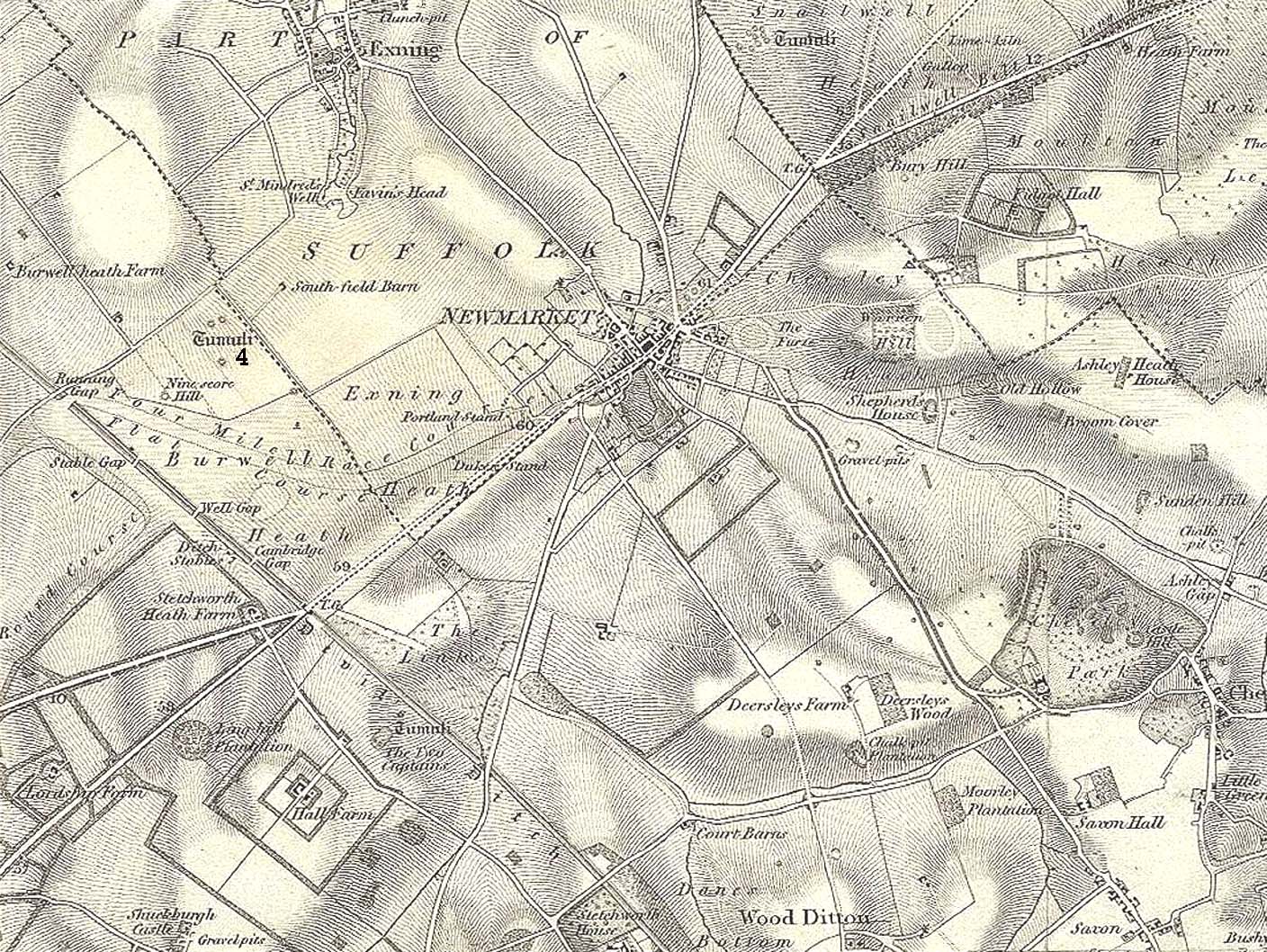
Tumulus 4, centre-left
This is one of at least five prehistoric tombs that were known to have existed in and around the Newmarket race-course. It could be seen five-hundred-and-odd yards northeast of the Ninescore Hill tumulus and about 280 yards southeast of its Newmarket Heath 2 companion. The site was shown as one of the “tumuli” on the 1834 OS-map (right) but, along with its friends, was destroyed sometime around 1883. Unlike its companions, no scar of its remains are visible from the air so we don’t know how big it was, but I’d assume the olde fella to be of a similar size and style to its close neighbours.
Royal Commission Ancient Historical Monuments, Inventory of Historical Monuments in the County of Cambridgeshire – Volume 2: North-East Cambridgeshire, HMSO: London 1972.
Tumulus (destroyed): OS Grid Reference – TL 6091 6304
Also Known as:
Newmarket Heath 1
Ninescore Hill Barrow
Archaeology & History
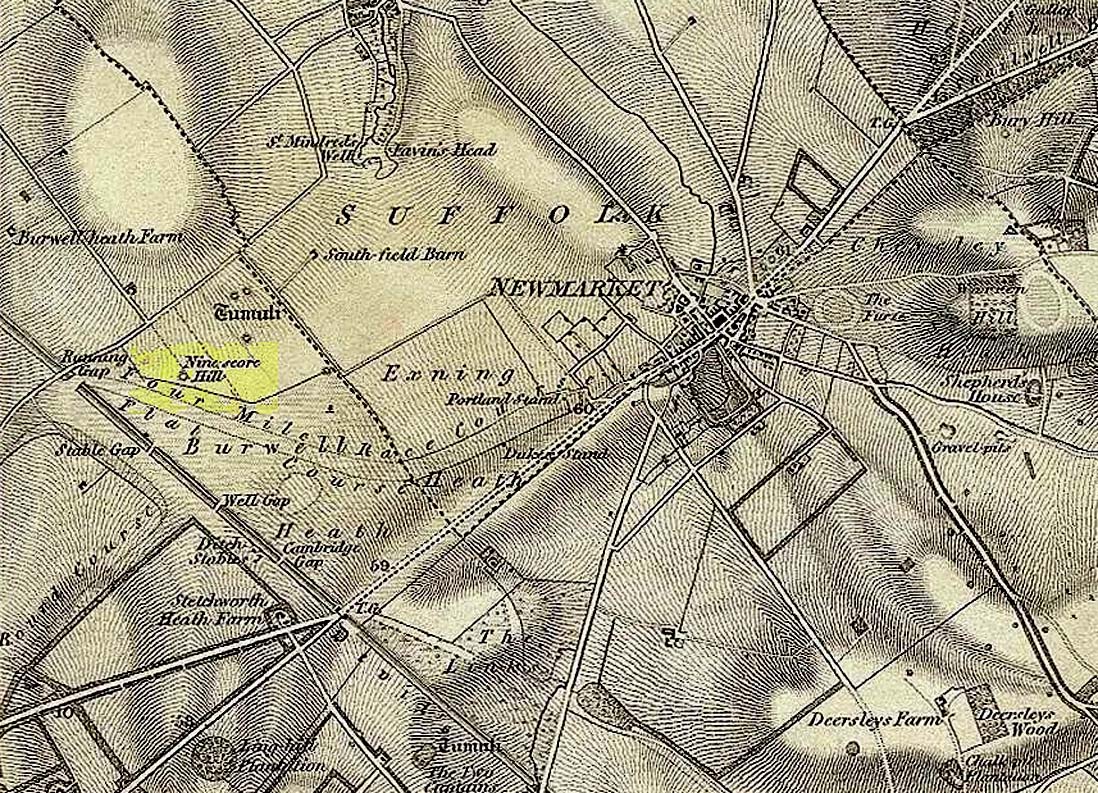
Ninescore Hill on 1834 map
Upon the small and curiously-named Ninescore Hill on the edge of Newmarket’s race-course, the old-school archaeologist Cyril Fox (1923) told that “800 yards due east of Running Gap”, was a prehistoric burial mound that was destroyed in 1885. Highlighted on the 1834 OS-map, a 19th century excavation found that the tomb “contained two inhumation interments associated with beakers,” along with some “flint arrowheads, and a secondary interment, probably Saxon.” In more recent times, the doods from the Royal Commission (1972) added the site to their inventory and noted that a faint outline—known as as ring ditch—is visible from the air when conditions are just right. But there’s bugger all left of it at ground level.
References:
Fox, Cyril, The Archaeology of the Cambridge Region, Cambridge University Press 1923.
Royal Commission Ancient Historical Monuments, Inventory of Historical Monuments in the County of Cambridgeshire – Volume 2: North-East Cambridgeshire, HMSO: London 1972.
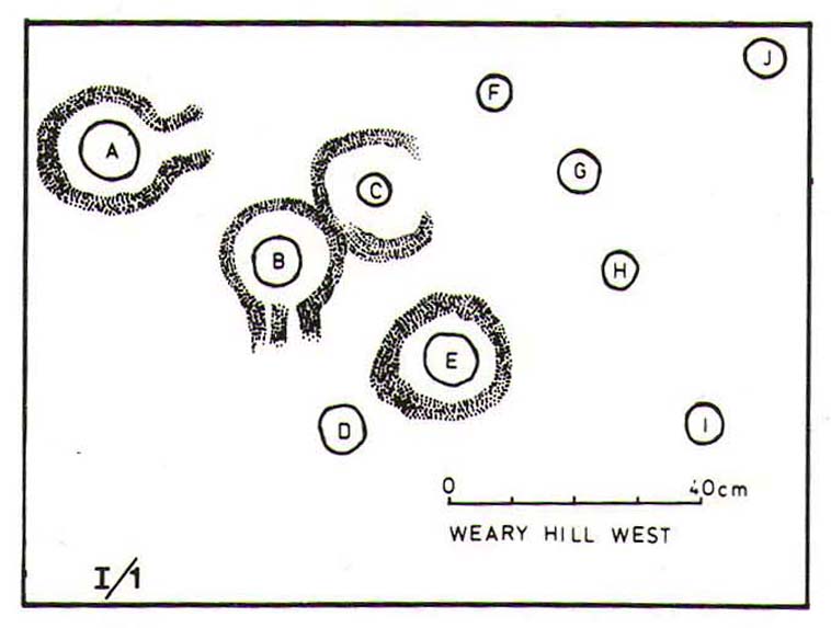
From Ilkley town centre take the road up to White Wells (ask any local if y’ can’t find it), but instead of heading up the track to the wells, keep on the road and, after just over 200 yards, turn left up the Keighley Road. Half-a-mile up there’s a dirt-track on your right which leads to Silver Well Farm. Walk along here for about 150 yards, keeping your eyes peeled for a large rock in the heather about 50 yards up onto the moor. You’ll find it.
Archaeology & History
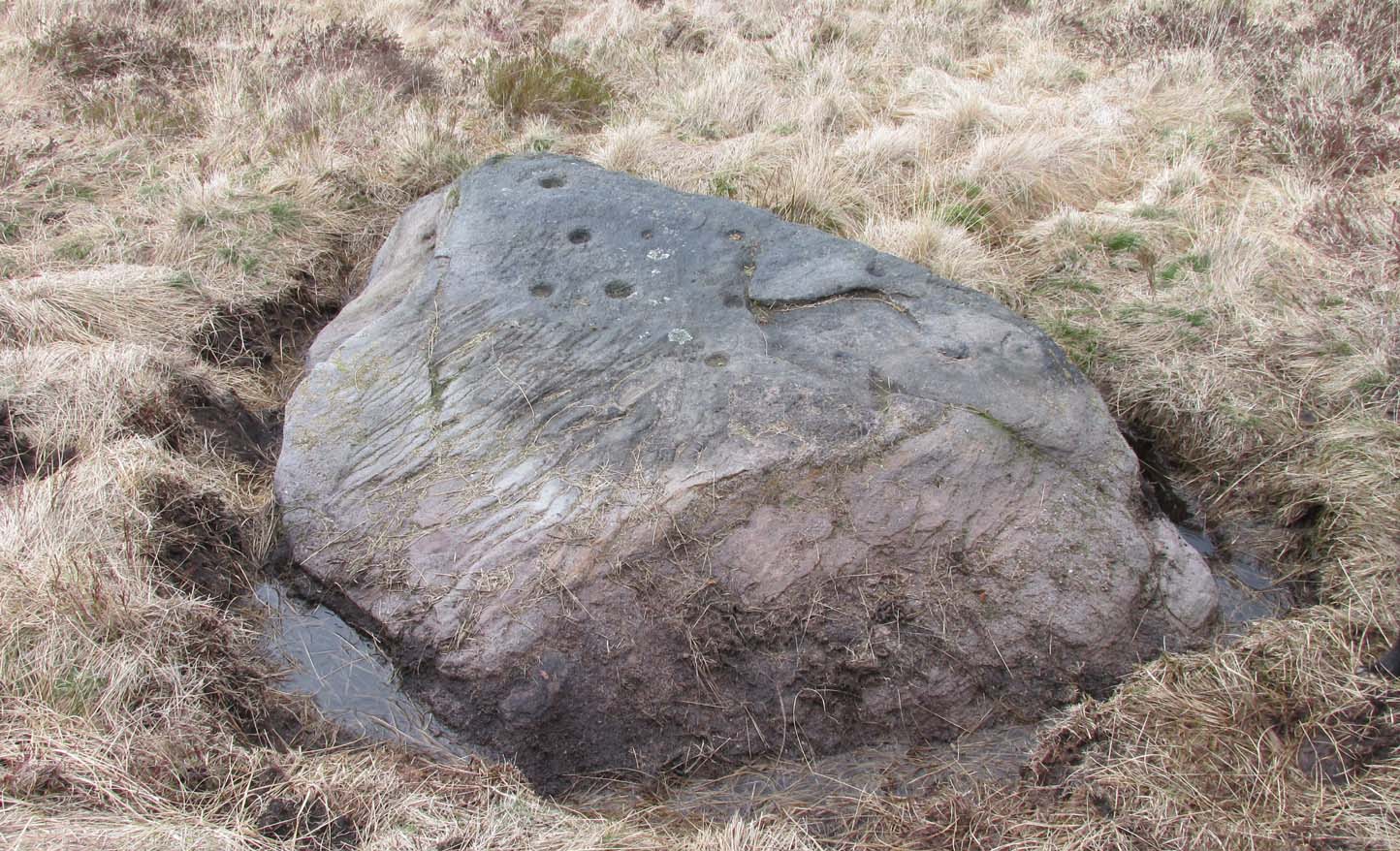
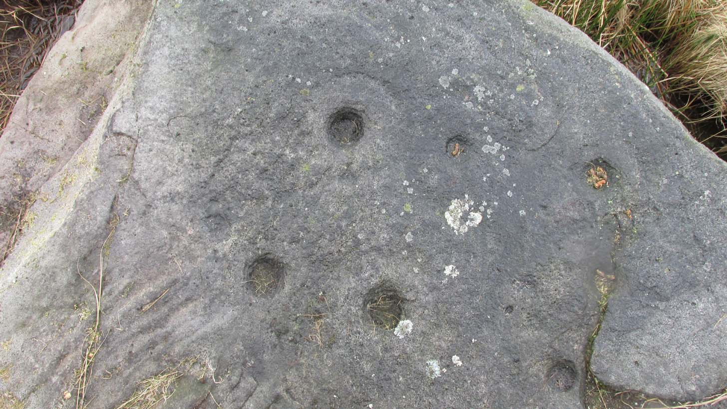
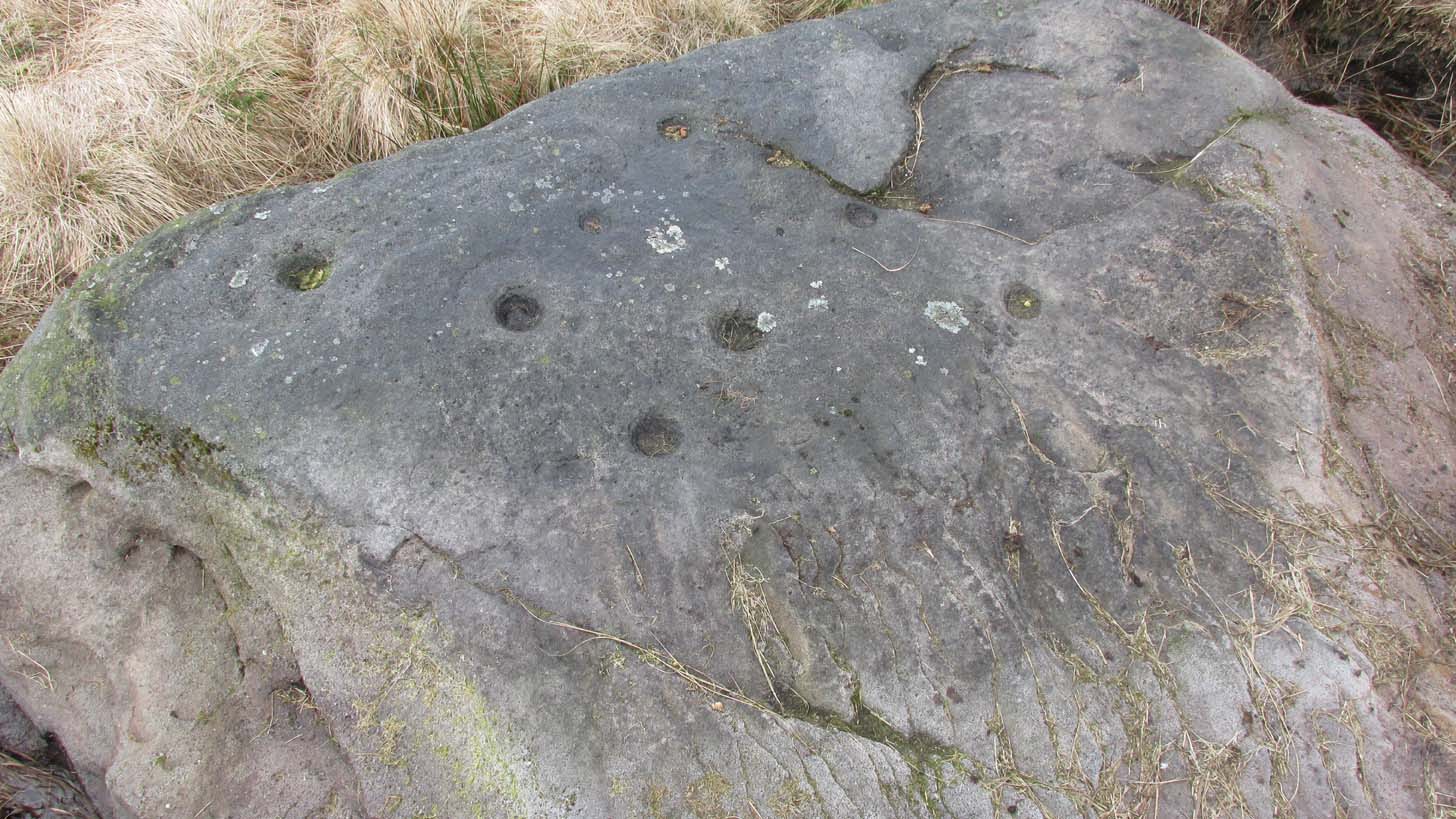
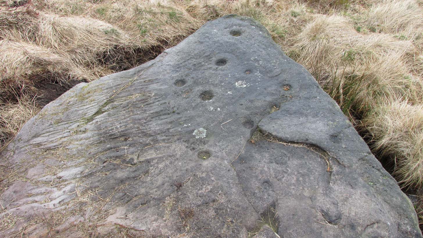
Located just 100 yards west of the old Roman road that effectively runs north-south through the middle of Rombalds Moor and which, when this carving was executed, was a prehistoric trackway, this is an impressive carving, all but unknown by many. On my last visit to this stone—maybe 10 years ago or more—it was a cloudy day. I know this from the fact that the design on the stone was difficult to see in its entirety. But not anymore! When the northern antiquarian Dave Whittaker came a-wandering this way a few years back, the stone so overgrown in vegetation that the design was very difficult to appreciate and, like any healthy curious antiquarian, he wanted to know what the full carving would look like. He enquired whether or not it was OK to uncover the stone from beneath its mass of heather to see the full image and, as far as we were concerned the idea was a good one. And so, following in the footsteps of Beckensall, Currie, Chappell, me and a few others, he got stuck in!
Cup-and-rings from above (photo by Dave Whittaker)Looking across the stone (photo by Dave Whittaker)
As you can see in Dave’s fine photos, the petroglyph is indeed a fine one. It comprises mainly of four cup-and-rings, two of which are incomplete The rings, as you can see, are very faint, whilst the cups, both in the rings and those outside of them, are notably deep; perhaps indicating that they were carved into many times over a long period.
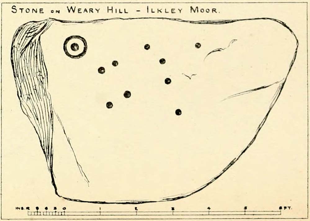
One of the great petroglyphic pioneers, J.Romilly Allen (1882) seems to have been the earliest to record this carving. Allen’s early sketch (below) was obviously drawn on a shady day, as it misses several of of the rings that are clear to see when the the daylight is just right. It’s an easy mistake to make. He wrote:
J.R. Allen’s 1882 sketchHedge’s 1986 sketch
“One mile south-west of Ilkley is a road leading over the top of the Moor…very appropriately as Weary Hill. To the west of the road, and between it and the boundary-wall of Silver Well Farm, is a small boulder of gritstone with cup-markings on it. It lies at a level of 900 ft. above the sea, and it measures 8ft by 5ft. On its upper surface, which is nearly level, are carved ten cups, varying in diameter from 2 to 3 ins., one of them being surrounded by a single ring.”
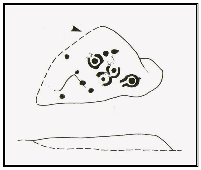
The pseudonymous “A. Reader” (1891) also included the stone in his international overview of prehistoric carvings, but merely copied the notes of his predecessors. Nearly a hundred years later when archaeologist John Hedges (1986) did his survey of these moors, he described this carving simply as:
“Medium seized rock…in grass, heather and crowberry with c.ten cups, four with rings, two with grooves from rings, three depressions and series of probably natural lines running down to bottom edge.”
And as with the pseudonymous A. Reader (1891), Boughey & Vickerman’s (2003) also just copied Hedges’ earlier description.
Seeking numeracy in Alan Davis 1988 sketchAnd from another angle (photo by Dave Whittaker)
The greatest analysis of this carving to date is by physicist and mathematician Alan Davis. He set out in 1983 to explore the possibility of there being a universal measurement used in neolithic times that was coded into our cup-and-rings—a theory first espoused by the great archaeo-astronomer Alexander Thom. (1968) He selected carvings from Rombalds Moor and Northumberland, including this one at Weary Hill (calling it the I/1 carving) to see if a ‘megalithic inch’ (MI) that was propounded by Thom had any foundation in fact. As a mathematician he was ideally qualified to examine this proposition. His 1983 paper found there to be “substantial support” for this prehistoric megalithic inch. However, in a subsequent 30-page analysis of the same carvings Davis (1988) found that some criteria in his initial investigation needed re-examining. In his updated report he told that “many of these deficiencies have now been remedied.”
His initial 1983 report concluded the Weary Hill carving possessed a deliberate mathematical code in accordance with Thom’s MI. However in the subsequent 1988 report, Davis found that the measurements were based on 5MI and 3 MI, but only in the cup-and-rings and not the single cups. Despite this, there remained an overall scepticism in terms of any deliberate universal use of the MI. My own take on this is a simple one: there was no deliberate use of any MI at carvings. Where we do find precise MIs, this is due simply to the average size of human hands, meaning that some obvious figurative correspondences will occur upon investigation. The more you think about it, the more obvious it becomes.
Anyhow, all this intriguing geometry aside: to those of you who take the time to check this out, have a bimble in the heather barely 100 yards west and you’ll find a few other carvings sleeping quietly, whose site profiles I’ve yet to do…
References:
Allen, J. Romilly, “Notice of Sculptured Rocks near Ilkley,” in Journal of the British Archaeological Association, volume 38, 1882.
Anonymous, Walks Around Cup and Ring Stones, ITIC: Bradford n.d. (1995)
Boughey, K.J.S. & Vickerman, E.A., Prehistoric Rock Art of the West Riding, WYAS: Leeds 2003.
Collyer, Robert & Turner, J. Horsfall, Ilkley, Ancient and Modern, William Walker: Otley 1885.
Davis, Alan, ‘The Metrology of Cup and Ring Carvings near Ilkley in Yorkshire,’ in Science and Archaeology, 25, 1983.
Davies, Alan, ‘The Metrology of Cup and Ring Carvings,’ in Ruggles, C., Records in Stone, Cambridge 1988.
Hedges, John (ed.), The Carved Rocks of Rombald’s Moor, WYMCC: Wakefield 1986.
Reader, A., Archaic Rock Inscriptions, privately printed: London 1891.
Thom, Alexander, “The Metrology and Geometry of Cup and Ring Marks,” in Systematics, volume 6, 1968.
Turner, J. Horsfall, Historical Notices of Shipley, Saltaire, Idle, Windhill, Wrose, Baildon, Hawksworth, Eccleshill, Calverley, Rawdon and Horsforth, Shipley Express: Idle 1901.
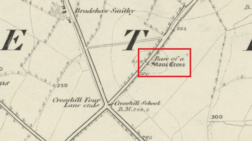
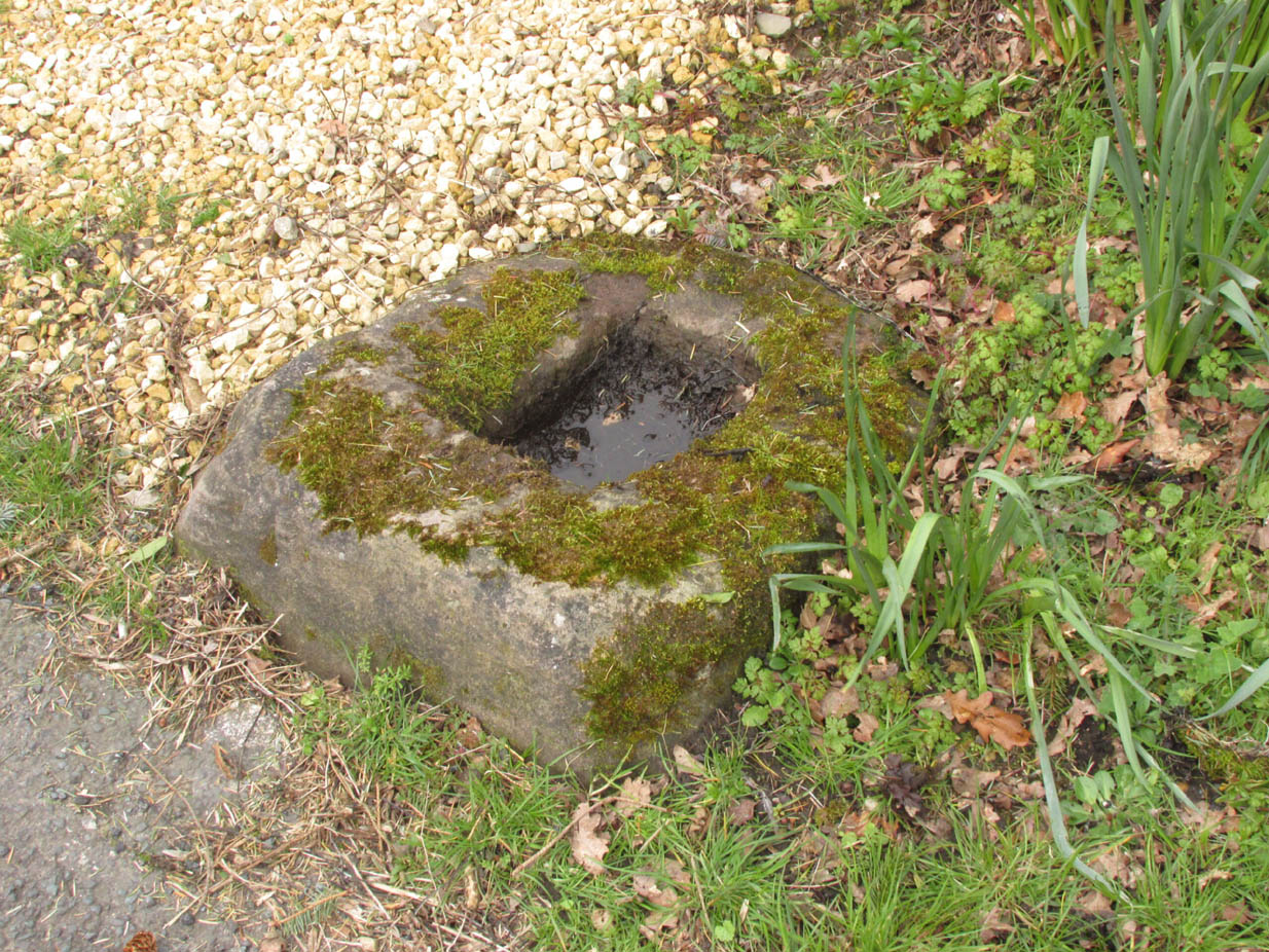
Follow Long Lane northwards from Scorton, over the crossroads at Crosshill Four Lane Ends, and the cross base will be found at the road edge immediately to the right of the driveway of ‘Sandalwood’ on the left hand side of the road.
Archaeology & History
Described in the Historic Buildings listing citation as:
“Cross base, probably mediaeval. A sandstone boulder, roughly rectangular, with rectangular socket.”
Cross base at the roadside‘A sandstone boulder, roughly rectangular’
The base of one of the numerous mediaeval wayside crosses that once adorned this part of Lancashire. So what happened to the cross? It’s possible that it was wilfully destroyed in the early nineteenth century as we have a likely culprit in the person of the Reverend Richard ‘Cross Smasher’ Wilkinson (c.1791 – 1823), Curate of Whitechapel, who took it upon himself to destroy the symbol of his religion wheresoever he could find it.
Immediately to the north west of the Cross is Cross Hill. The cross itself was probably a waymarker on the road over Harrisend Fell from Oakenclough, and Bradshaw may be the name of the locality, there being a Bradshaw Bridge just outside Street to the north west, while the 1846 6-inch OS map records a ‘Bradshaw Smithy’ on the same road.
From East Morton village, take the moorland road, east, and up the steep hill. Where the road just about levels out there’s a right turn, plus (more importantly!) a trackway on your left which leads onto the moor. Walk up this track for ⅔-mile until you get to the point where the moorland footpath splits, with one bending downhill to an old building, whilst the other smaller footpath continues on the flat to the north. Go up here for 400 yards then walk off-path, right, for about about 150 yards. But beware – it’s boggy as fuck!
Archaeology & History
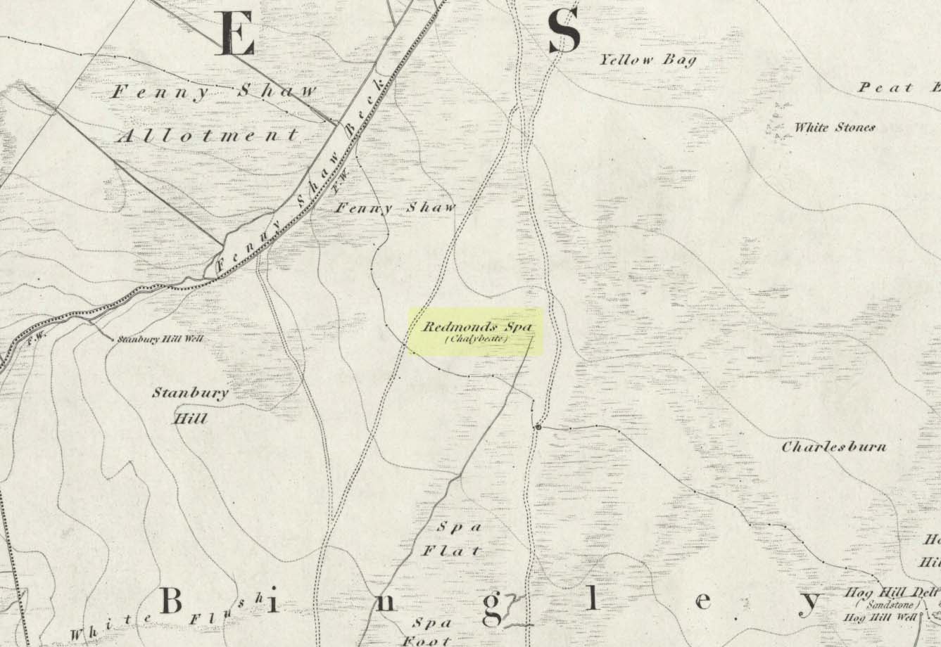
On this featureless southern-side of Rombalds Moor, all but lost and hidden in the scraggle of rashies, a very boggy spring emerges somewhere hereabouts. I say hereabouts, as the ground beneath you (if you can call it that!) is but a shallow swamp and its actual source is almost impossible to locate. If you want to find the exact spot yourself, be prepared to put up with that familiar stench of bog-water that assaults our senses when we walk through this sort of terrain. Few are those who do, I have found… But somewhere here, amidst this bog—and still shown on the OS-maps—is the opening of what is alternatively called Redman’s or Richmond’s Spa. We don’t know exactly when it acquired its status as a spa-well, but the 18th century Halifax doctor, Thomas Garnett—who wrote the early work on the Horley Green Spa—appears to be the first person to describe it. Garnett (1790) said how the place:
“was first mentioned to me by Mr W. Maud, surgeon, in Bradford, who went with me to see it. It is situated on Romalds-moor, about two or three miles from Bingley, and goes by the name of Redmire-spaw. The access to it is by no means good; the ground about it being very spongy and soft. On the bottom and sides of the channel is deposited an ochrey matter, of a very fine, bright, yellow colour; and which I believe is used, by the country people in the neighbourhood, to paint their houses. It sparkles when poured into a glass and has a taste very like the Tewit-well at High-Harrogate; which water it very much resembles in all its properties, and seems to be about the same strength… This water seems to hold a quantity of iron dissolved by means of fixed air. Its taste is very pleasant; it is said to act very powerfully as a diuretic, when drank in considerable quantity, and may prove a useful remedy, in cases where good effects may be expected from chalybeates in very small doses; the fixed air, and even the pure water itself may be useful in some cases. It is, however, necessary to drink it at the well, for it seems to lose its iron and fixed air very soon.”
I’ve drank this water, and believe me!—it doesn’t quite taste as pleasant as Mr Garnett espouses! Its alright I s’ppose—but drinking water from a bog isn’t necessarily a good idea. That aside, I find it intriguing to hear so much lore about such a little-known spring; and it is obvious that the reputation Garnett describes about this spa came almost entirely from the local people, who would have been visiting this site for countless centuries and who would know well its repute. Below the source of the well the land is known as Spa Flat, and slightly further away Spa Foot, where annual gatherings were once held at certain times of the year to celebrate the flowing of the waters. Such social annual gatherings suggests that the waters here were known about before it acquired its status as a spa—which would make sense. The remoteness of this water source to attract wealthy visitors (a prime function of Spa Wells) wouldn’t succeed and even when Garnett visited the place, he said how he had to travel a long distance to get here.
The origin of its name was pondered by the great Harry Speight (1898) who wondered if it derived from the ancient and knightly Redman family of Harewood, whose lands reached over here. But he was unsure and it was merely a thought. As an iron-bearing spring (a chalybeate) you’d think it might derive from being simply a red mire or bog (much like the Red Mire Well at Hebden Bridge), but its variant titles of apparent surnames casts doubt on this simple solution.
No one visits the place anymore. Of the countless times I’ve wandered the moors, rare have been the times when I’ve seen folk anywhere near this old spring. It is still coloured with the same virtues that Garnett described in the 18th century: the yellowish deposits, the boggy ground, much of which reaches to the truly dodgy Yellow Bog a short distance north and which should be completed avoided by ramblers after heavy rains (try it if y’ don’t believe me—but you’ve been warned!).
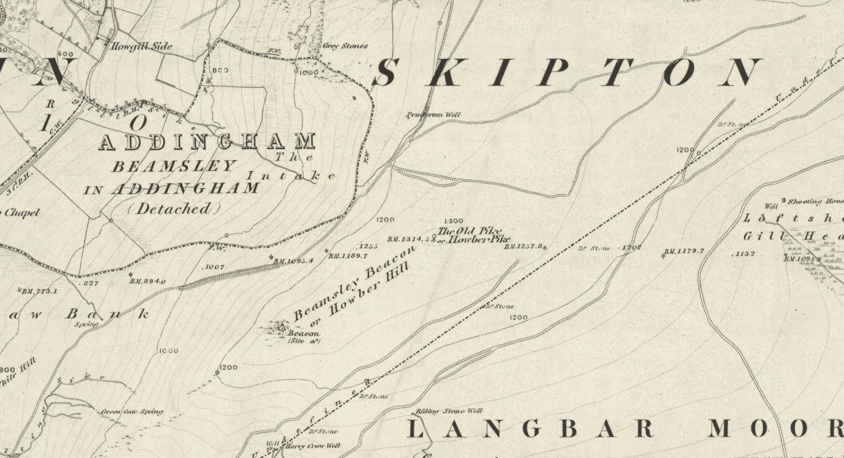
I prefer the much longer walk to this site, from Askwith Moor carpark some 5 miles to the west, but this wouldn’t be most folks cuppa tea. So for the lazy buggers amongst you: whether you’re coming via Ilkley (cross the bridge to Middleton and turn left, following the long winding road for several miles) or Bolton Bridge (hit Beamsley village and turn left up Lanshaw Bank), you need to get up to Langbar village. On the north side of the village is a distinct small rough carpark. From here, cross the road where the footpath sign is and walk straight up the steep hill to Beamsley Beacon at the top. Keep walking for exactly ¼-mile where you’ll find a large heap with boulders round its edge. You’re there.
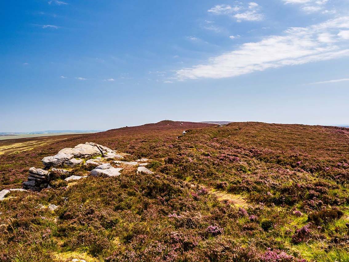
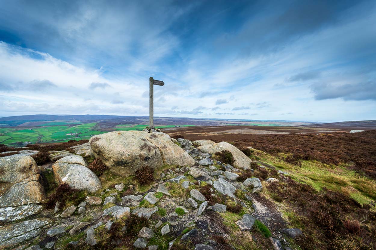
At the highest point of these hills where the moorlands of Langbar and Beamsley meet, is this prominent rocky pile on the same skyline as Beamsley Beacon. The two are ancient cairns, both robbed of most of their stones, but still a good site to sit and behold the vast landscape which reaches out for miles in all directions. And, from this highest point, looking south to the highest point across the Wharfe valley on Ilkley Moor, the remnants of another giant prehistoric cairn is visible: looking across at each other, eye to eye.
Of the two great cairns on Beamsley moor, The Old Pike is the more peculiar of the two because—unlike its partner along the ridge—several large boulders near its top give the impression of being Nature’s handiwork. This may be the case, but Nature isn’t the lass who laid down the mass of smaller rounded stones that are mainly visible on the west and southern sides. These have been placed there by people. But it’s not until you step back 40 or 50 yards that you get a more distinct impression of the place. The Old Pike rises up like a rocky nipple out of the heath, showing a very embedded overgrown man-made heap, typical of the overgrown prehistoric cairns that scatter our northern uplands.
The site is included on the archaeologist’s Pastscape website, albeit citing it as a ‘possible’ cairn. But the more we look at it, the greater the impression becomes that this old heap is man-made – certainly on its eastern and southern sides. The rise of boulders on its west may be natural, and then ancient man placed the cairn material up and around them. Only an excavation would tell us for sure. But its old name of Howber Pike tells a tale before we even visit the place. When the great Yorkshire historian Harry Speight (1900) came here he picked up on this element, telling us,
“Howber literally is the ‘Hill of Tombs’, from the Teutonic haugr and Anglian how, a burial mound, and berg also her, a hill, often fortified.”
The great place-name authority A.H. Smith (1956) not only echoes this but goes into greater etymological detail, noting that as well as haugr or how being “an artificial mound, a burial mound,” it’s a word that is particularly used in the northern counties. He does note however, that this may not always be the case and can sometime just relate to a “a hill or hilltop resembling an artificial mound.” However, we also find in Smith’s tome on place-name elements that the latter part of ‘Howber’ deriving from beorg, can also mean a tumulus or burial mound. But there are cases where this has been corrupted and means, as Speight states, a fortified hill. So at Howber Pike we seem to have the ancient name of some probable burial site. As for its neighbour a quarter-mile west, the giant cairn of Beamsley Beacon is also known as the Howber Hill….
References:
Smith, A.H., English Place-Name Elements – volume 1, Cambridge University Press 1956.
Smith, A.H., The Place-Names of the West Riding of Yorkshire – volume 5, Cambridge University Press 1963.
Speight, Harry, Upper Wharfedale, Elliott Stock: London 1900.
Acknowledgements: Huge thanks to James Elkington for use of his fine photos on this site.