Holy Well (destroyed?): OS Grid Reference — SJ 8464 9036
Archaeology & History
In Henry Taylor’s gigantic survey on the Ancient Crosses and Holy Wells of Lancashire (1906), he told that “records of the existence of holy wells in this (district) are scanty in the extreme.” Indeed. He certainly missed this one which, it seems (if modern lore is correct), has sadly fallen prey to that sickness which those ghastly people call ‘progress’. Cited to have been in or near the old graveyard of St. James church in the old village, this once ever-flowing spring of water was of great repute in earlier centuries, not only for general health, magick and traditions, but also supposedly in prolonging life itself!
One of the standard historians of Didsbury, Mr Fletcher Moss (1898), was of the view that this Well may have been the “origin of Didsbury, the place the Saxon settlers would choose first for their church and community.” He may be right. He told that,
“It was said ‘to be holy in papist times.’ Only last summer I several times saw three young ladies who came every morning to bathe their eyes and faces in it, saying, “It was good for sore eyes.” I could not see anything the matter with their eyes, but that may have been my ignorance, or that they were already getting better. In the spring time or early in May the well has often been nearly choked with wild flowers, and pins have been put in for luck. If rags or crutches were ever left there, it was when the water bubbled up in the roadway on the hillside. The flow of it is lessened by drains or sewers, and now it is taken down in pipes. The lane is enclosed with brick walls, and all the romance is gone; but in the longest drought or severest frost the water from the holy well has never failed, and though it may come from the churchyard, we and many others drink no other.”
In an earlier passage (Moss 1891), he talked about the longevity and good health of the local people and who credited the good water here:
“Like most of the old Didsbury folk who never bothered with doctors or change of air, Sam Gaskill, the last clerk, lived to be long past the fourscore years, for I remember him and others much older than he was, regularly going to the Holy Well for the water for their households. As in patriarchal and primitive times the villagers went to the well or spring at eventide and tarried and talked while the water flowed. It mattered nought to them that the water flowed from the churchyard, from the burial-place of their forefathers; they had always been healthy as their forefathers had been healthy, and they wanted no other water and would have no other; that always bubbled up fresh and sparkling in summer or winter, in drought or frost, and never failed.”
Nearby to the east, spirits of the dead were said to come from the old trees of Parrs Wood, long since destroyed by those self-righteous Industrialists…
References:
Million, Ivor R., A History of Didsbury, E. J. Morten 1969
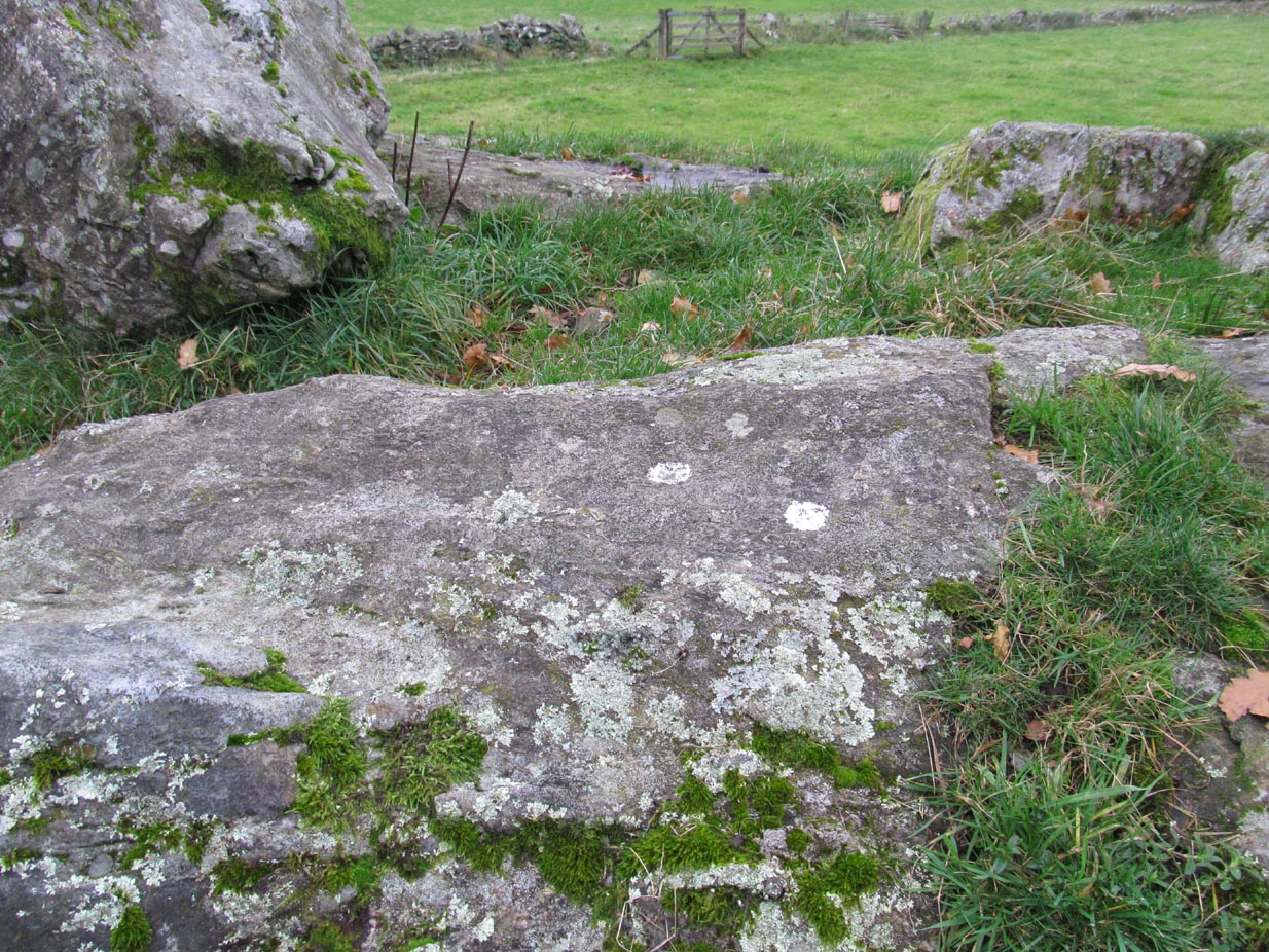
Take the same directions as if you’re going to the nearby Moirlanich 2 Carving (about 550 yards down Glen Lochay, on the north side of Killin). In the same field, about 150 yards northwest of Moirlanich 2, you’ll see another large rock close to the wall. That’s the spot!
Archaeology & History
Cup-marks highlighted
Looking down upon the River Lochay, with views east and west along the glen, here we find a carved rock that’s probably of interest only to the petroglyphic purists amongst you. Two simple cup-markings, about 5 inches apart, can be seen etched into the slightly sloping southern-face of this small rocky outcrop. The sacred mountain of the Creag na Cailleach rises to the immediate north.
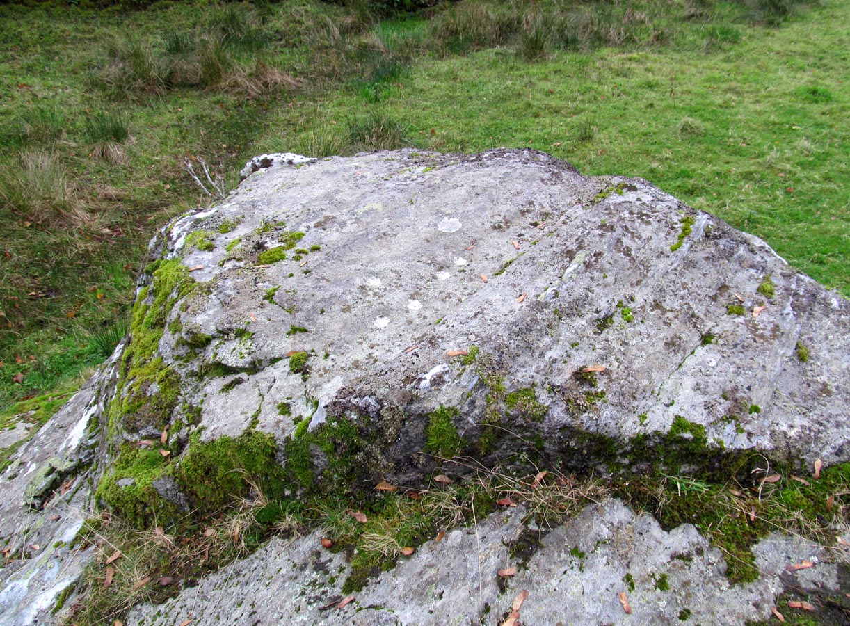
From Killin, take the A827 road out of the north side of the village, turning left down Glen Lochay just before the Bridge of Lochay Hotel. 500 yards along the single-track road you’ll reach the electricity station. Just past this, in the field on your right, a large rock stands out just a few yards away. Go through the gate and walk to the spot!
Archaeology & History
Highlighted cup-marks
This is a simple cup-marked stone, perhaps used in ages gone by as a look-out spot by villagers. Only for the petroglyphic purists amongst you, this carving consists of just five cup-marks on the topmost section of the flat stone, with four of them roughly in a line and a solo one (the most pronounced of the them all) a few inches south of the row. The cup-marked Moirlanich 1 stone can be seen in the same field, 150 yards (137m) to the northwest.
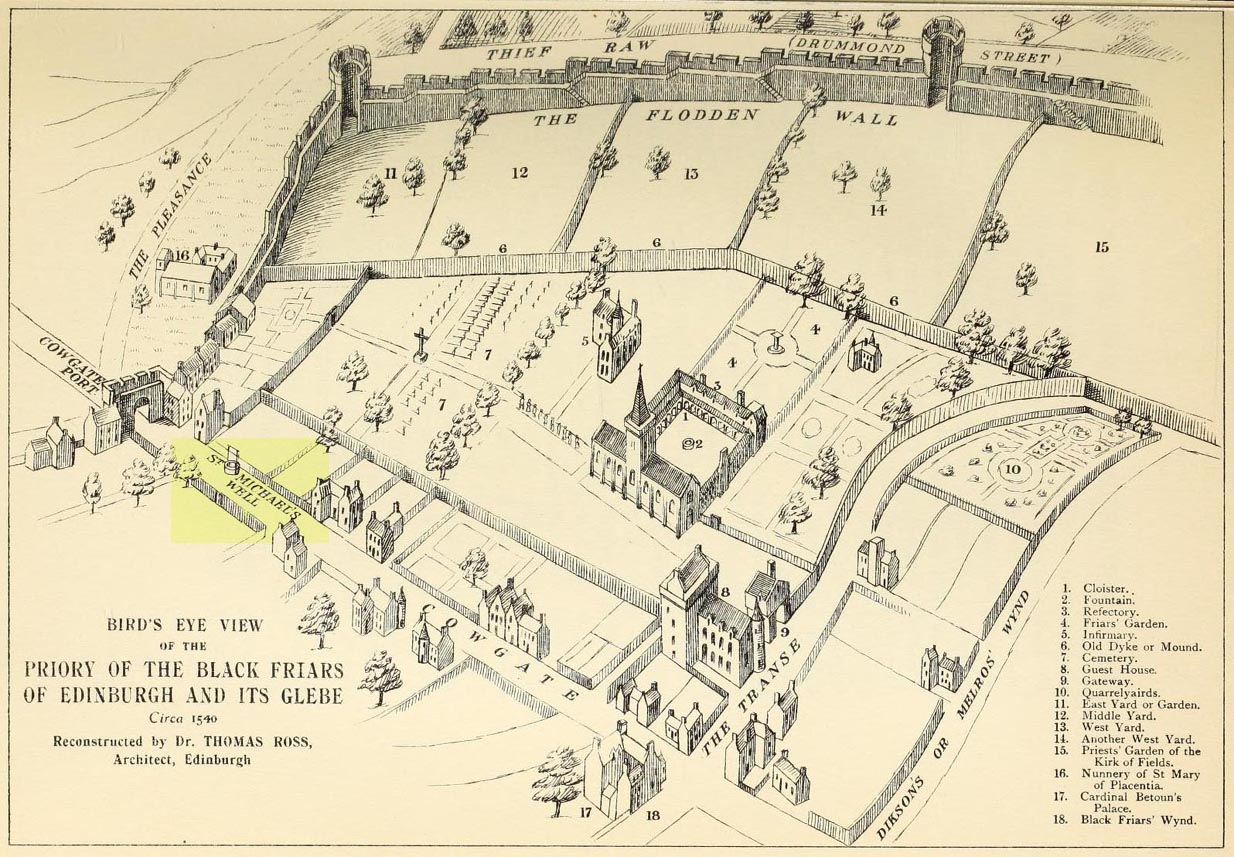
This ‘holy well of the dragon-slayer’ could once be found close to where old Cowgate meets St Mary’s Street. Highlighted on an old map of the city around 1540, and on Mr Bryce’s sketch of the old inner city at the end of the 19th century, we do not know when the Well acquired its name, but it may have been by an early group of jews, to whom the saint was important. Hereby in 1779 was listed a small piece of land called the ‘Silverwell Close’ which both Watson (1923) and Harris (1996) thought was a corruption of the St Michael’s Well, somehow. Watson (1923) explained that St Michael’s
“connection with fountains, or a ‘silver well’, is probably due to the legends of the miraculous spring of Monte Galgano in Apulia and Mont-Saint-Michele in Normandy.”
In Ruth & Frank Morris’ (1981) survey of Scottish holy wells, they report how, in the 16th century, this forgotten site was “a favourite resort” of local people. They told how,
“in 1543 an act of penance was ordered to be performed at the fountain of St. Michael.”
The greatest scattering of accounts relating to St Michael’s Well are found in the Records of the Burgh of Edinburgh, wherein we read:
29 July, 1556: “The prouest baillies and counsale foirsaid deputtis Dauid Symmer to be oursear of the well callit Sanct Michaellis well, and Johne Loch to the Mvs well, to caus tham be maid depar and preparit for watter gaddering.”
16 December, 1556: “The prouest baillies and counsale ordanis the thesaurar Alexander Park Auent the to reperell the wcllis callit Sanct Michaellis well, the Mws well, and the Stok well, and to begyn thairto at Sanct Mongois day nixt tocum, and ordanis Maister Johne Pirstoun to be oursear to Sanct Jlichaelis well, Johne Loch to the Mws well, and Alexander Barroun to the said Stok well, and quhat expens he makis thairon salbe allowit to him.”
Folklore
St Michael was a powerful mythic figure to the Muslims, Christians and Jews. In the old calendar in Scotland his festival date was September 29th and known as ‘Michaelmas’ (although other dates have been ascribed by the varying sects in other countries). In truth, this site should be highlighted for tourists, pilgrims, historians and religious followers alike due to the importance this mythic figure once held in the various pantheons.
Cup-and-rings on gatepost (photo credit, Dave Whittaker)
From Ilkley, follow the same directions as if you’re going up to the superb Swastika Stone. Keep walking on the footpath, west, for 65 yards (59m), then walk into the heather on your left. Barely 5 yards in, you’ll see this fallen standing stone or gatepost.
Archaeology & History
First described in one of Stuart Feather’s (1964) old rambles, I first saw this stone in my late-teens and was as puzzled by it then as I am today. Upon an obviously worked stone that may once have stood upright (or was intended to do), two faint and incomplete cup-and-rings were carved – but when exactly? If this stone was cut from a larger rock into its present shape, were the petroglyphs already on it, or were they done when the ‘gatepost’ was created?
It was first described in one of Stuart Feather’s (1964) rambles up here and later included in Hedges’ (1986) survey, where he told it to be a, “recumbent gatepost with one cup with almost complete ring and one cup with vestigial ring.” Boughey & Vickerman’s (2003) survey added little more. And when a group calling itself Carved Stones Investigation got itself about £250,000 to “investigate” the Ilkley petroglyphs, I was hoping that they could have at least turned this stone over to see if other carvings were on the stone – but they just revisited all those found by others, made a new list, and took the money to be honest (no website and no book – as they should’ve done). Thankfully, local folk are having a look at this and others and doing the work they should have. Check it out when you’re next up at the Swastika.
References:
Bennett, Paul, Megalithic Ramblings between Ilkley and Baildon, unpublished: Shipley 1982.
Boughey, Keith & Vickerman, E.A., Prehistoric Rock Art of the West Riding, WYAS: Wakefield 2003.
Feather, Stuart, “Mid-Wharfedale Cup-and-Ring Markings: no.26, 27, 28 – Black Pots, High Moor, Silsden, near Keighley,” in Cartwright Hall Archaeology Group Bulletin, 9:10, 1964.
Hedges, John, The Carved Rocks on Rombalds Moor, WYMCC: Wakefield 1986.
Acknowledgements: Huge thanks to Dave Whittaker for the photo. Good luck with the plans fellas.
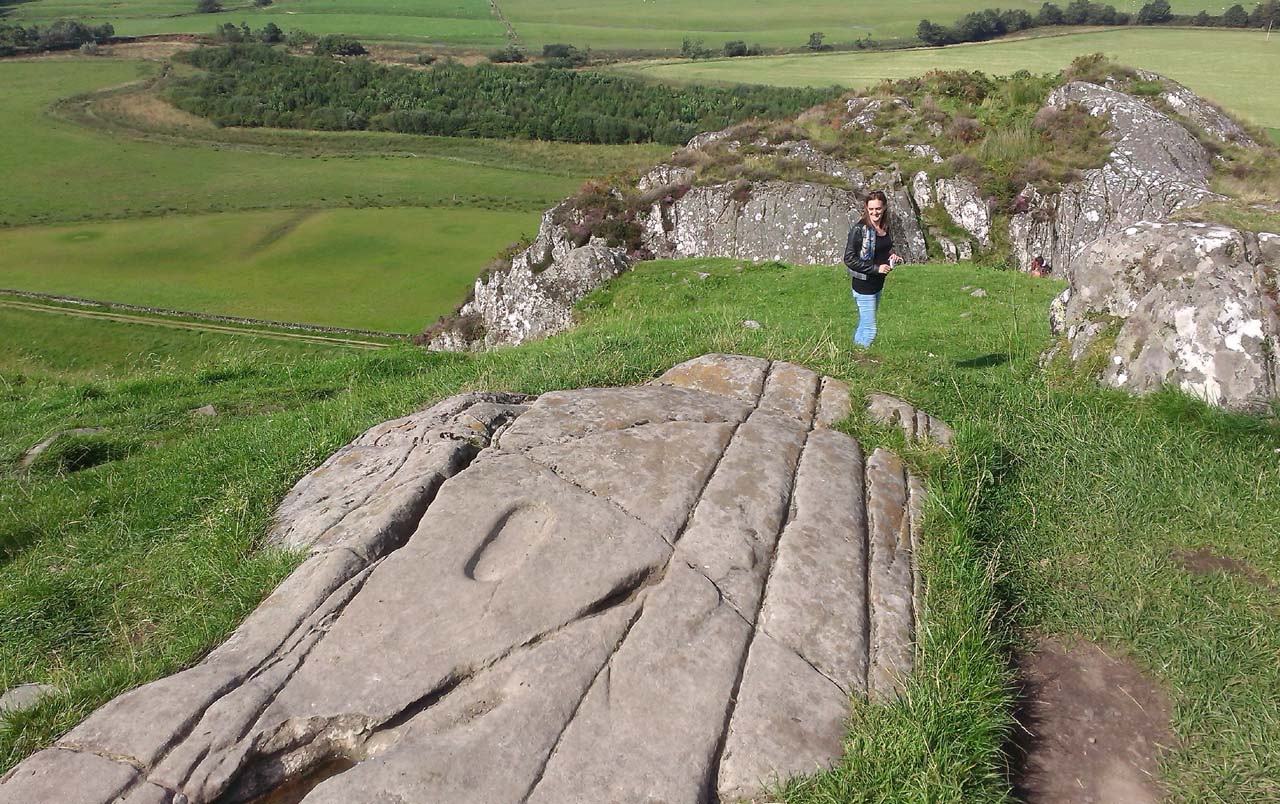
From Lochgilphead, take the A816 road north for several miles (towards the megalithic paradise of Kilmartin), keeping your eyes peeled for the road-signs saying “Dunadd.” Turn left and park-up a few hundred yards down. Go through the gate and walk up Dunadd. Just before the flattened plateau at the top, a length of smooth stone is accompanied to its side by the deep cup-and-ring of the Dunadd Basin. Three or four yards away, you’ll see the long ‘footprint’.
Archaeology & History
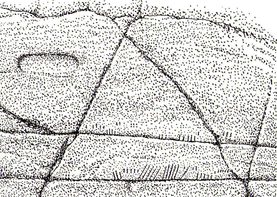
Near the top of Dunadd’s Iron Age ‘fortress’ and overlooking the megalithic paradise of the Kilmartin valley, several man-made carvings are in evidence very close to each other, all with seemingly differing mythic content. This one—the footprint—stands out; but it’s not alone! Faint etchings of at least one other ‘foot’ is clearly visible. The first literary account of it was by Ardrishaig historian R.J. Mapleton (1860), who told,
“There is on the top of Dunadd a mark that strikes me as interesting; it is like a large axe-head, or a rough outline of a foot. My impression is that it may have been the spot on which the chief would place his foot when succeeding to the headship of his tribe. The footmark was always considered among the people here as a mould for an axe-head, and I was rather laughed at for suggesting an inaugurating stone.”
Dunadd Footprint (after Royal Commission 1988)F.W.K. Thomas’ 1879 sketch
Be that as it may, a few years later the carving had caught the attention of the Scottish Society of Antiquaries. In his article exploring the potential for ritual inaugurations at Dunadd, Captain F.W.L. Thomas (1879) explored, not only the footprint, but the mythic functions of this symbol, looking at parallels with petroglyphs elsewhere in the world where the ‘foot’ was known to be a ritual inauguration symbol (amongst other things). He gave us the first real detailed account of the carving:
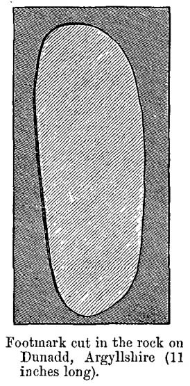
“About 10 or 12 feet below, and to the northward of the highest point, the living rock is smooth, flat and bear of sward, and in it is engraved an impression of a footmark, not of a naked foot, but such as would be made when the foot is clothed by a thick stocking or cuaran… The engravure is for the right foot; and it exactly fitted my right boot. The footmark is sunk half-an-inch deep, with perpendicular sides, the surface is smoothed or polished, and the outline is regular… It has probably been sheltered by the turf until recently. The footmark is 11 inches long, nearly 4½ inches broad where broadest, and 3½ inches across at the heel. When a person stands with his foot in the depression, he looks a little easterly of north.”
A century or so later when the Royal Commission (1988) boys got here, they found not one, but two ‘feet’ carved into the rock! A few feet away, near to the carved boar,
“At the south end of the main rock surface there is the lightly-pecked outline of a shod right foot. 0.24m long and 0.1m in maximum width, with a pronounced taper to the heel. There are further peck marks within the outline, and a sunken footmark was intended but not completed. This print is on almost the same alignment as the more prominent footprint some 2m to the north, which measures 0.27m from NNE to SSW, by 0.1m in maximum width and 25mm in depth. It is somewhat broader at the heel than the incomplete mark, and its sides are straighter.”
Close-up of the carving
They then emphasize how we’re unable to date the footprints, although point out how such carvings are “found in Britain from the Iron Age onwards.” But footprints have be found on other petroglyphs in Scotland (much less in England) and date between the neolithic and Bronze Age periods—but whether Dunadd’s example goes that far back, we cannot say. Extensive excavations occurred at Dunadd between 1980-81 and most of the finds were Iron Age and early medieval in nature (this carving and the cup-and-ring barely got a mention in Lane & Campbell’s [2000] extensive summation). But we may be looking at an evolutionary developmental relationship in symbolism and form, if the traditions of the place have any substance. This is something I’ll return to when writing of the Boar Carving, just a few feet away…
Folklore
The legends behind this seemingly insignificant mark near the top of Dunadd ostensibly echo and relate to the huge cup-and-ring of Dunadd Basin four yards away. I can only repeat what I said in that site profile.
R.J. Mapleton (1860) said that Dunadd was known by local people to be a meeting place of witches and the hill of the fairies, whose amblings in this wondrous landscape are legion. Legends and history intermingle upon and around Dunadd. Separating one from the other can be troublesome as Irish and Scottish Kings, their families and the druids were here. One such character was the ever-present Ossian. Mapleton told:
“From these ancient tales we turn to a much later period of romance, when Finn and his companions had developed into extraordinary and magical proportions; a story is current that when Ossian abode at Dunadd, he was on a day hunting by Lochfyneside; a stag, which his dogs had brought to bay, charged him; Ossian turned and fled. On coming to the hill above Kilmichael village, he leapt clean across the valley to the top of Rudal hill, and a second spring brought him to the top of Dunadd. But on landing on Dunadd he fell on his knee, and stretched out his hands to prevent himself from falling backwards. ‘The mark of a right foot is still pointed out on Rudal hill, and that of the left is quite visible on Dunadd, with impressions of the knee and fingers.’”
As Mr Thomas (1879) clarified:
“The footmark is that of the right foot, and the adjacent rock-basin is the fabulous impression of a knee.”
References:
Bord, Janet, Footprints in Stone, Heart of Albion Press 2004.
Campbell, Marion, Mid-Argyll: An Archaeological Guide, Dolphin Press: Glenrothes 1984.
Campbell, M. & Sanderman, M., “Mid-Argyll: An Archaeological Survey,” in Proceedings of the Society Antiquaries, Scotland, volume 95, 1962.
Craw, J.H. “Excavations at Dunadd and other Sites,” in Proceedings of the Society Antiquaries, Scotland, volume 64, 1930.
Lane, Alan & Campbell, Ewan, Dunadd: An Early Dalriadic Capital, Oxbow: Oxford 2000.
Mapleton, R.J., Handbook for Ardrishaig Crinan Loch Awe and Pass of Brandir, n.p. 1860.
Morris, Ronald W.B., The Prehistoric Rock Art of Argyll, Dolphin Press: Poole 1977.
Royal Commission on the Ancient & Historical Monuments of Scotland, Argyll – Volume 6: Mid-Argyll and Cowal, HMSO: Edinburgh 1988.
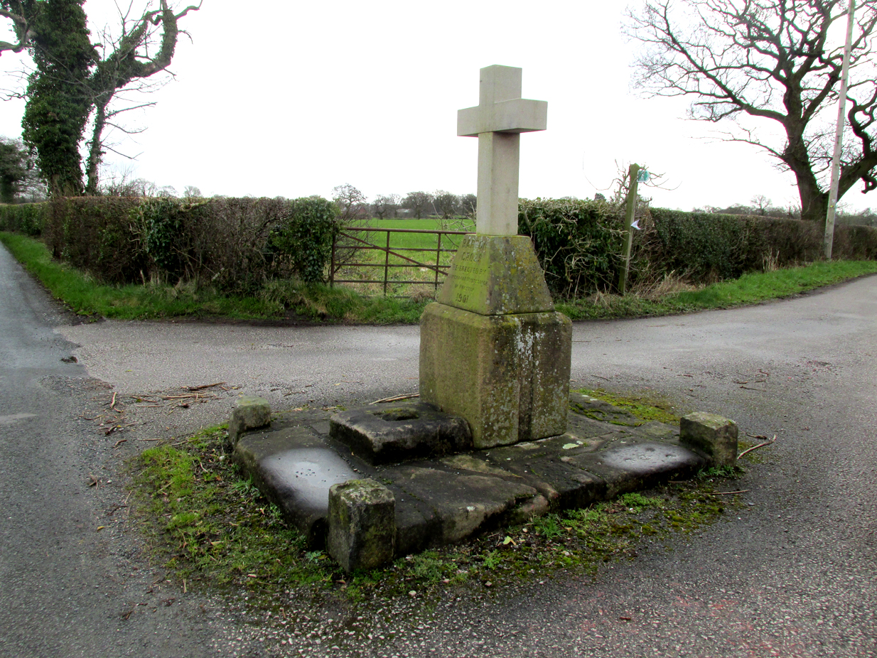
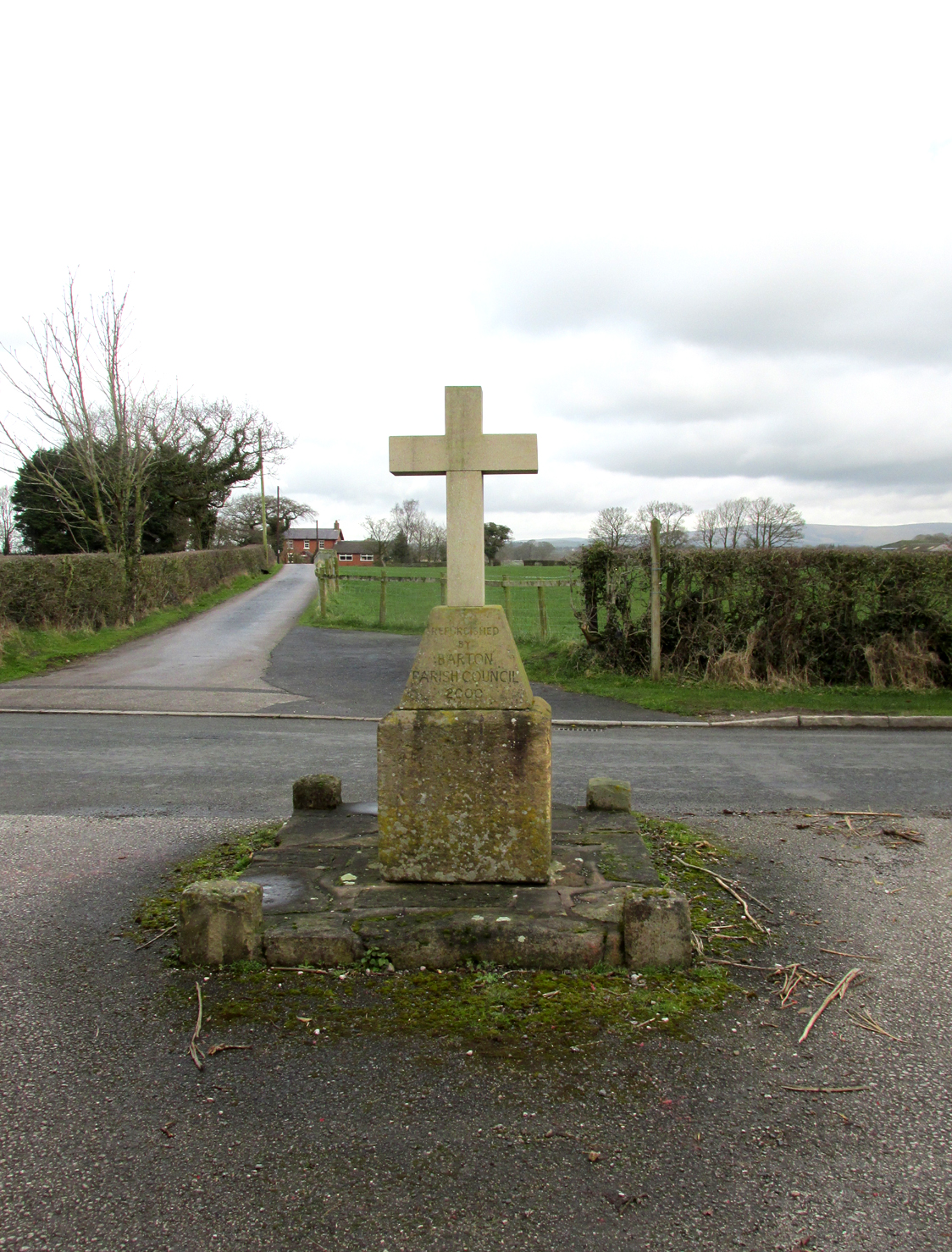
The Barton Cross from the road, showing the original socketed base and the cup marked paving stone to the right.
The cross is at the roadside on the south side of Barton Lane at the cross roads with the minor road between Cross House Farm and Barton House.
Archaeology and History
All that survives is the socketed base of a mediaeval cross on a raised paved platform with low raised square section pillars at each corner. Behind the original cross socket stands a large stone block (Described in the Historic England citation as “probably part of a cheesepress“) surmounted by a pyramidal block upon which a modern carved stone cross has been placed.
Henry Taylor (1906) writes in his Ancient Crosses and Holy Wells of Lancashire:
The South face of the Cross
“Barton Cross. These words occur on the map in ancient Gothic letters in Barton Lane, one and a half miles in a westerly direction from Goosnargh Church, showing that in the year 1848 a complete cross stood here. The site is at the intersection of country lanes, and the map shows a small recess or lay-bye in which the cross was planted. Mr. Collinson [Reverend S.E. Collinson, Vicar of Broughton] writes that the base was thrown into a neighbouring pit at the time Daniel’s pedestal was buried. The base and part of the shaft of the Barton Cross have lately been restored to the old site. A new cross has been erected just behind by Mr. Myerscough. Mr. Collinson tells me that in going through some of the old parish registers he found an entry referring to ‘Barton Christ’. He not unnaturally thinks that there must have been a figure on the Cross giving rise to the name. Nothing else would account for it. The neighbourhood of Barton (a pre-Norman settlement) is interesting and deserves a thorough investigation.”
The ‘Daniel’s pedestal’ refers to Daniels Cross, near Broughton, of which Taylor writes:
“The base was removed about sixty years ago. It is now in a neighbouring pit. The facts were obtained from an old man who helped at the destruction of this landmark.”
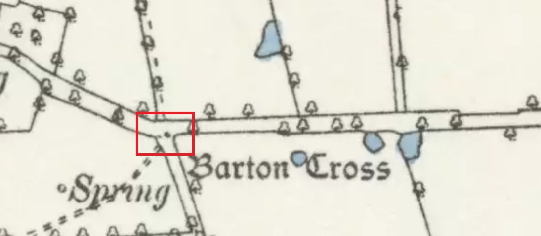
The 1895 6″ map showing the Cross, with the nearby marl-pits coloured blue
The pyramidal stone block upon which the modern cross stands is inscribed on the northern face: “Barton Cross re-erected by Councillor R. Myerscough of Preston 1901” while the southern face is inscribed: “Refurbished by Barton Parish council 2000“.
One of the paving stones that surround the cross has pre-historic cup markings on it, and is the subject of a separate site profile.
Bearing in mind what was written about the original cross having been ‘thrown into aneighbouring pit’, it may be worth probing the nearby marl pits to see whether the original could be found.
Reference:
Taylor, Henry, The Ancient Crosses and Holy Wells of Lancashire, Manchester, Sherratt and Hughes, 1906
Inside the once prominent prehistoric tomb on the Cow Keeper’s Field, the northern antiquarians William Hornsby and John Laverick (1920) came across two small petroglyphs in association with a cremation burial, several feet south of the central cist: the Cow Keeper’s Field 2 carving, plus this small, triangular-shaped stone, 8in by 6in, consisting of five standard cup-marks, with two of the cups (as the photo shows) connected to each other. It is akin to the numerous ‘portable’ cup-marked stones which, in other cultures, were deposited onto cairns in remembrance of the ancestral spirits of the tomb. Such widespread practices may also have occurred here. Petroglyph researcher and writer Graeme Chappell (2017) informed us that the carving “is in storage in the Dorman museum in Middlesborough.”
References:
Brown, Paul & Chappell, Graeme, Prehistoric Rock Art in the North York Moors, Tempus: Stroud 2005.
Chappell, Graeme, Personal communication, October 4, 2017.
Crawford, G.M., Bronze Age Burial Mounds in Cleveland, Cleveland County Council 1990.
Elgee, Frank, Early Man in North-East Yorkshire, John Bellows: Gloucester 1930.
Hornsby, William & Laverick, John D., “British Barrows round Boulby,” in Yorkshire Archaeological Journal, volume 25, 1920.
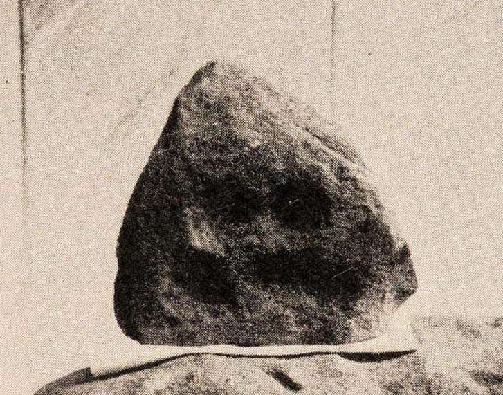
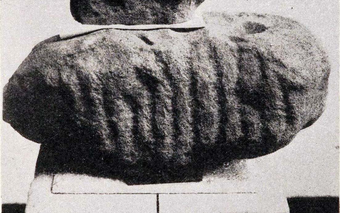
Inside the once prominent prehistoric tumulus on the Cow Keeper’s Field (now destroyed), the northern antiquarians William Hornsby and John Laverick (1920) came across two small portable petroglyphs: the Cow Keeper’s Field 1 carving, plus this “peculiarly marked stone” as they put it, some “5ft south of the centre” where a cist, or stone-lined burial existed. Measuring 18in by 7in, the rock carving consists of at least one large cup-marking which is clearly evident on top of the stone, plus what seems to be another one next to it, half-covered. Along the side of the stone, a series of twelve roughly parallel lines have been carved out, running down to the bottom of the stone. Rock art researcher and writer Graeme Chappell (2017) tells us the carving is supposed to be “in storage in the Dorman museum in Middlesborough,” although no one has seen it in years. It would be worthwhile if fellow research students could visit the said museum to recover this and other portable cup-marked stones that were found in the area.
References:
Brown, Paul & Chappell, Graeme, Prehistoric Rock Art in the North York Moors, Tempus: Stroud 2005.
Chappell, Graeme, Personal communication, October 4, 2017.
Crawford, G.M., Bronze Age Burial Mounds in Cleveland, Cleveland County Council 1990.
Elgee, Frank, Early Man in North-East Yorkshire, John Bellows: Gloucester 1930.
Hornsby, William & Laverick, John D., “British Barrows round Boulby,” in Yorkshire Archaeological Journal, volume 25, 1920.
This prehistoric tomb was one in a cluster of tumuli in the Boulby district, uncovered by the northern antiquarians, William Hornsby and John Laverick in 1918. Most of them have subsequently been destroyed – this one included. When they visited the site, they described it as “a barrow…with a diameter of 36 feet.” Once they began digging into it,
“at the centre we found a cist, the top of which was 2ft 7in below the present surface. The cist lay north 64° west, and south 64° east. It had no cover and the slab at the north-west end was wanting. The cist measured: side 3ft 6in, end 3ft 2in. Its depth was 2ft 2in. In it we found nothing except sandstone chips. With these there was no admixture of soil. Above the cist and covering a space of 5 ft by 5 ft there was a layer of burnt earth and black ashes (of furze bushes). At a distance of 5 ft south of the centre, and 1ft 10in below the present surface, there was a burnt burial, 20in in diameter. With this we found many flint chips, a shale pendant, and the peculiarly marked stone” we’ve called, simply the Cow Keeper’s Field 2 carving.
A second cup-marked stone was also found inside the tomb, a few feet south of the cist. When G.M. Crawford went to survey the burial mound in the late 1970s, he reported “there is no trace of it” and “has probably been destroyed by ploughing.”
References:
Brown, Paul & Chappell, Graeme, Prehistoric Rock Art in the North York Moors, Tempus: Stroud 2005.
Crawford, G.M., Bronze Age Burial Mounds in Cleveland, Cleveland County Council 1990.
Elgee, Frank, Early Man in North-East Yorkshire, John Bellows: Gloucester 1930.
Hornsby, William & Laverick, John D., “British Barrows round Boulby,” in Yorkshire Archaeological Journal, volume 25, 1920.