Cow Keeper’s Field (1), Boulby, Easington, North Yorkshire

Cup-Marked Stone:  OS Grid Reference – NZ 75398 19218

Also Known as:

  1. BOU-5 (Brown & Chappell)

Archaeology & History

Cup-marked stone inside Cow keepers Field tomb

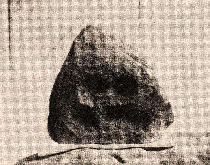
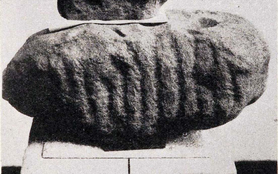
Inside the once prominent prehistoric tomb on the Cow Keeper’s Field, the northern antiquarians William Hornsby and John Laverick (1920) came across two small petroglyphs in association with a cremation burial, several feet south of the central cist: the Cow Keeper’s Field 2 carving, plus this small, triangular-shaped stone, 8in by 6in, consisting of five standard cup-marks, with two of the cups (as the photo shows) connected to each other.  It is akin to the numerous ‘portable’ cup-marked stones which, in other cultures, were deposited onto cairns in remembrance of the ancestral spirits of the tomb.  Such widespread practices may also have occurred here.  Petroglyph researcher and writer Graeme Chappell (2017) informed us that the carving “is in storage in the Dorman museum in Middlesborough.”

References:

  1. Brown, Paul & Chappell, Graeme, Prehistoric Rock Art in the North York Moors, Tempus: Stroud 2005.
  2. Chappell, Graeme, Personal communication, October 4, 2017.
  3. Crawford, G.M., Bronze Age Burial Mounds in Cleveland, Cleveland County Council 1990.
  4. Elgee, Frank, Early Man in North-East Yorkshire, John Bellows: Gloucester 1930.
  5. Hornsby, William & Laverick, John D., “British Barrows round Boulby,” in Yorkshire Archaeological Journal, volume 25, 1920.

© Paul BennettThe Northern Antiquarian 


Cow Keeper’s Field (2), Boulby, Easington, North Yorkshire

Cup-and-Ring Stone:  OS Grid Reference – NZ 75402 19222

Also Known as:

  1. BOU-5 (Brown & Chappell)

Archaeology & History

Cup-marks and linear forms

Inside the once prominent prehistoric tumulus on the Cow Keeper’s Field (now destroyed), the northern antiquarians William Hornsby and John Laverick (1920) came across two small portable petroglyphs: the Cow Keeper’s Field 1 carving, plus this “peculiarly marked stone” as they put it, some “5ft south of the centre” where a cist, or stone-lined burial existed.  Measuring 18in by 7in, the rock carving consists of at least one large cup-marking which is clearly evident on top of the stone, plus what seems to be another one next to it, half-covered.  Along the side of the stone, a series of twelve roughly parallel lines have been carved out, running down to the bottom of the stone.  Rock art researcher and writer Graeme Chappell (2017) tells us the carving is supposed to be “in storage in the Dorman museum in Middlesborough,” although no one has seen it in years.  It would be worthwhile if fellow research students could visit the said museum to recover this and other portable cup-marked stones that were found in the area.

References:

  1. Brown, Paul & Chappell, Graeme, Prehistoric Rock Art in the North York Moors, Tempus: Stroud 2005.
  2. Chappell, Graeme, Personal communication, October 4, 2017.
  3. Crawford, G.M., Bronze Age Burial Mounds in Cleveland, Cleveland County Council 1990.
  4. Elgee, Frank, Early Man in North-East Yorkshire, John Bellows: Gloucester 1930.
  5. Hornsby, William & Laverick, John D., “British Barrows round Boulby,” in Yorkshire Archaeological Journal, volume 25, 1920.

© Paul BennettThe Northern Antiquarian


Cow Keepers Field, Boulby, Easington, North Yorkshire

Tumulus (destroyed):  OS Grid Reference – NZ 75400 19220

Also Known as:

  1. Boulby Barns

Archaeology & History

This prehistoric tomb was one in a cluster of tumuli in the Boulby district, uncovered by the northern antiquarians, William Hornsby and John Laverick in 1918.   Most of them have subsequently been destroyed – this one included.  When they visited the site, they described it as “a barrow…with a diameter of 36 feet.”  Once they began digging into it,

“at the centre we found a cist, the top of which was 2ft 7in below the present surface. The cist lay north 64° west, and south 64° east.  It had no cover and the slab at the north-west end was wanting.  The cist measured: side 3ft 6in, end 3ft 2in.  Its depth was 2ft 2in.  In it we found nothing except sandstone chips.  With these there was no admixture of soil. Above the cist and covering a space of 5 ft by 5 ft there was a layer of burnt earth and black ashes (of furze bushes).  At a distance of 5 ft south of the centre, and 1ft 10in below the present surface, there was a burnt burial, 20in in diameter.  With this we found many flint chips, a shale pendant, and the peculiarly marked stone” we’ve called, simply the Cow Keeper’s Field 2 carving.

A second cup-marked stone was also found inside the tomb, a few feet south of the cist. When G.M. Crawford went to survey the burial mound in the late 1970s, he reported “there is no trace of it” and “has probably been destroyed by ploughing.”

References:

  1. Brown, Paul & Chappell, Graeme, Prehistoric Rock Art in the North York Moors, Tempus: Stroud 2005.
  2. Crawford, G.M., Bronze Age Burial Mounds in Cleveland, Cleveland County Council 1990.
  3. Elgee, Frank, Early Man in North-East Yorkshire, John Bellows: Gloucester 1930.
  4. Hornsby, William & Laverick, John D., “British Barrows round Boulby,” in Yorkshire Archaeological Journal, volume 25, 1920.

© Paul BennettThe Northern Antiquarian 


The Falls (1), Boulby, Easington, North Yorkshire

Cairn:  OS Grid Reference – NZ 74954 19429

Also Known as:

  1. Rockcliff Beacon

Archaeology & History

Tumulus on 1920 map

Occupying a prominent position above the ever-closer North Sea, upon which an old beacon was subsequently placed, this denuded prehistoric tomb was first surveyed by the Ordnance Survey lads in 1913, and subsequently in an essay by Messers Hornsby & Laverick (1920) on the ancient sites of Boulby, east of Easington.  This was the first one they explored, calling it ‘Mound No.1.”  They located it,

“due south of the ‘Soldier’s Garth’ in the east corner of the field called The Falls.  It was a cairn with a diameter of 50ft.  Two-and-a-half feet northwest of the centre peg, at a depth of 21 inches below the present surface, there was an unaccompanied burnt burial, which occupied a space of 15in by 18in.  In a centre cut 7ft 6in by 6ft, at a depth of 3ft 6in, we found much burnt bone and many potsherds of the Bronze Age type, scattered over the whole space of the trench, down to a further depth of 3ft 10½in.  In the south corner there were four stones set on edge and running in a direct (straight) line.  The interment had been placed upon the clay, the soil of the original surface having been cleaned off.  With this burial we found a good flint made from a polished celt and worn smooth at the point—possibly through having been used for striking fire on iron pyrites—many chips and several cupstones.”

The “several” cup-marked stones they describe at the end seem to have been lost; perhaps sleeping in some museum cellar somewhere (does anyone know?).

This cairn was one in a complex of eight that Frank Elgee (1930) suggested may have been laid out deliberately in the form of the constellation of Ursa Major, or The Plough, also known as ‘Charles Wain’.

References:

  1. Brown, Paul & Chappell, Graeme, Prehistoric Rock Art in the North York Moors, Tempus: Stroud 2005.
  2. Crawford, G.M., Bronze Age Burial Mounds in Cleveland, Cleveland County Council 1990.
  3. Elgee, Frank, Early Man in North-East Yorkshire, John Bellows: Gloucester 1930.
  4. Hornsby, William & Laverick, John D., “British Barrows round Boulby,” in Yorkshire Archaeological Journal, volume 25, 1920.

© Paul BennettThe Northern Antiquarian